All Activity
- Past hour
-
And the tornado and macroburst in September 2010! I lost tons of large, mature trees in the 60 to 80 year old range in my neighborhood because of that stupid tornado. It did an incredible amount of damage to the canopy
-
Yeah. They are outstanding units that behave like a mini split. We have some of the most expensive electricty in the US in New England. Anyone not running one of these is just throwing money to Eversource. I don't think people realize how expensive electricty in New England is compared to the US. Top 5 most expensive according to the EIA monthly data.. Hawaii .4269 Connecticut .3325 RI .3307 California .3166 MA .3044 https://www.eia.gov/electricity/monthly/epm_table_grapher.php?t=epmt_5_6_a A traditional window AC unit just cycles the compressor on and off at full speed at like 800 watts. They usually end up running non-stop at like 800 watts when that much cooling power is often not necessary. These Midea U are using variable speed dc fans and compressor. They can throttle the compressor down to as low as like 150 watts and run up to max at the exact cooling load for the room. They are also like 10 times quieter at low speed. I
-
Got some good rain overnight. Probably around 2” total for the event.
-
Weekend not looking great again but the worst of it seems to be headed for our northern friends.
-
Large Enhanced now, but with the caveat of the event either being boom or bust
-

E PA/NJ/DE Spring 2025 Obs/Discussion
Hurricane Agnes replied to PhiEaglesfan712's topic in Philadelphia Region
After some light returns much of yesterday, I did finish up with 0.57". The significant rain has happened overnight and this morning where I am sitting on an additional 1.10" at post time, with a 2-day event total of 1.67". Got up to 68 for a high yesterday after a 60 low and currently have moderate rain (~1/3" - 1/2" per hr) and 58, with dp 58.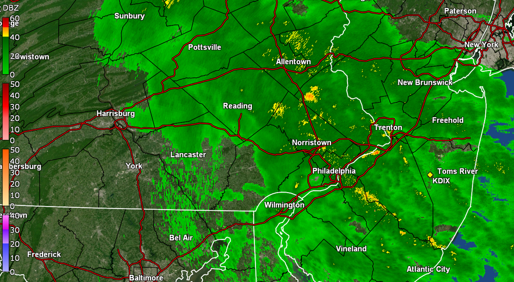
-
435 AM EDT Wed May 14 2025 ...FLOOD WARNING IN EFFECT FROM THIS EVENING TO FRIDAY EVENING... ...REPLACES RIVER FLOOD WATCH... * WHAT...Moderate flooding is forecast. * WHERE...Potomac River at Point of Rocks. * WHEN...From this evening to Friday evening. * IMPACTS...At 20.0 feet, The boat ramp and lower parking lot at Point of Rocks are flooded. Water approaches the water treatment plant in Brunswick. Farmland behind the Tarara Vineyard is flooded. At 22.0 feet, Water begins to cover the C&O Canal towpath near Point of Rocks and Brunswick. * ADDITIONAL DETAILS... - At 3:45 AM EDT Wednesday the stage was 4.3 feet, or 11.7 feet below flood stage. - Forecast...The river is expected to rise above flood stage late this evening to a crest of 21.4 feet early tomorrow afternoon. It will then fall below flood stage early Friday afternoon. - Flood stage is 16.0 feet. - Flood History...This crest compares to a previous crest of 21.4 feet on 01/27/2010.
-
Managed to get some rain overnight, although didn't get a flush hit from any of the cells. Most missed just to the west or east. Up to a half inch total.
-
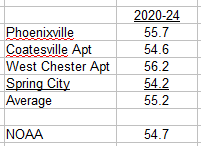
No I don't agree. below are the current county stations that I have data for, the non-DEOS stations. Spring City is cooler than any of the current stations that I have, consistent with its location in the far northern part of the county. Unlike your results, NOAA is cooler than the average of the current stations that I have. Shows how changing the station population changes the simple average. The DEOS stations that you have added cool the present on balance without adding any climate information due to their short period of operation. Results from your simple averaging method merely reflect the changing station population: relatively warm in the past and relatively cool now. You've obtained the "climate change isn't happening" result you are looking for. As I have said in the past you will be the last person to realize that Chester County is warming.
- Today
-
1.79 here in 21057
-
Heavy rain here
-
Imagine all the swarms of mosquitoes and sweaty dads cooking up burgers on Memorial Day after another monsoon rolls through. We tried to warn em!
-
It's been pouring all night here in the lowlands. The drought buster is real.
-
Although yesterday had no rainfall at KSAV, there currently is an isolated thunderstorm over KSAV currently.
-

Spring 2025 Medium/Long Range Discussion
Jackstraw replied to Chicago Storm's topic in Lakes/Ohio Valley
Uber drivers in Indy be prayin' for cool rain Memorial Day weekend. Have the The Fever at home, then the 500 AND Game 3 of the Eastern Conference finals (sorry to any of our OH brethren that had hope ) Sat and Sun respectively. Naptown be wakin up Memorial Day lol -
It may be the most potent storm in Stephens City history. A one in a thousand year storm.
-
Looks like the rains out here are finally collapsing as the stuff fires around the bay. Hopefully you guys cash in on some of that tonight. What a remarkable event for us westerners. I'll always remember this one.
-
Heavy rain and Thunder. Rain Rate 1.20 in/hr per the weather station.
-
Thunder and Lightning. Moderate to Heavy rain.
-

2024-2025 La Nina
Stormchaserchuck1 replied to George001's topic in Weather Forecasting and Discussion
Well the La Nina is officially over now.. this latest Kelvin wave neutralizing the subsurface is what did it. It's interesting that when this happens, and the SOI spikes negative is when we will finally see a strong -PNA in the N. Pacific (5-21 to 5-25) -
There was one from New Hyde Park that was crazy. I can't find it but i found a few more.
-
2023-4 cannot be unpinned. Its destiny is to be pinned for eternity because it did everything it wasn’t supposed to do and thus it’s important we learn from our mistakes.
-
Torrential rain and thunderstorm now. Just blew past 5".
-

2024-2025 La Nina
PhiEaglesfan712 replied to George001's topic in Weather Forecasting and Discussion
lol at this one getting unpinned before the 2023-24 thread. 2011 was a record wet August and September and 2013 was a record wet summer. Plus, that summer pretty much ended in late July. -
Friday is certainly interesting. To start, several models show some sort of early morning MCS. The NAM in particular has some steep lapse rates, which likely explains the signals for big hail. I'm not sure what the trigger would be for afternoon storms to form and take advantage of some positive factors, but it's definitely worth tracking.
- 493 replies
-
- 3
-

-
- severe
- thunderstorms
- (and 2 more)


