All Activity
- Past hour
-

2025-2026 ENSO
michsnowfreak replied to 40/70 Benchmark's topic in Weather Forecasting and Discussion
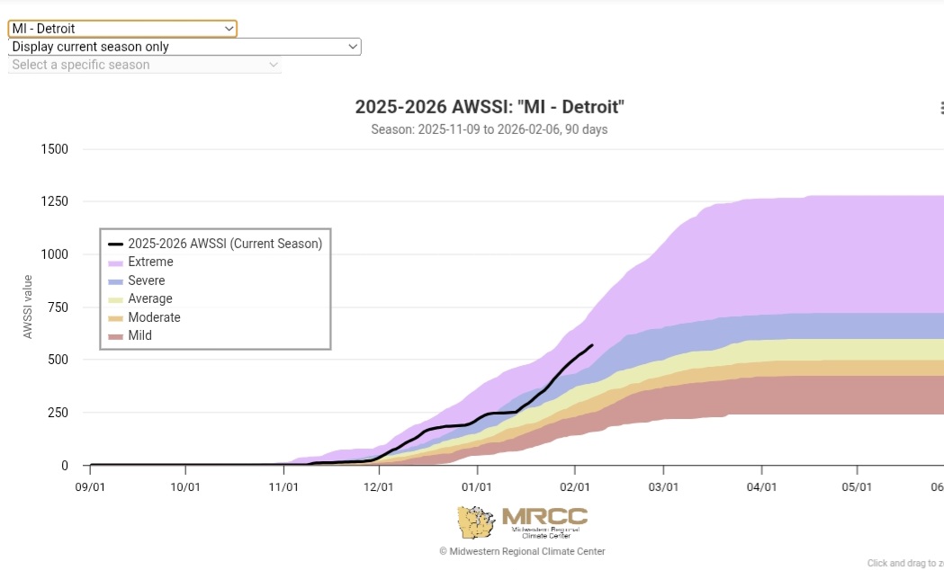
I've been a weather observer for 30 years. I live in an area that would be considered quite cold and snowy to the average American. The fact that the 3 climatologically coldest weeks of the year this year were the 3rd coldest on record IS impressive. The AWSSI winter severity index has this winter as "extreme". It doesn't change the warmth in other places which is oh so predictably constantly being brought up, it doesn't change cc, but I dont understand why weather forums suddenly become climate change lessons during times of regional cold. Why every arctic blast has to be scrutinized for its longevity or regional coverage. The hey day of weather forums as weather forums is LONG gone.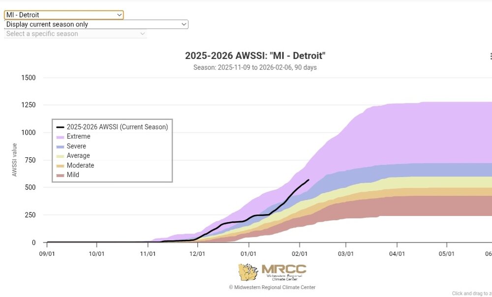
-
 Yes, you would also be leader with a max of 18, if 3 is confirmed as low (the contest runs through tomorrow so it would need to remain above 3 F tonight). A max of 16 or lower would give RJay the title, dmillz25 would win for a max of 19, and Sacrus for a max of 20. Snowfall only needed to separate RJay and you, as well as myself. There again RJay would have to avoid 0.6" to 1.4" snow through Tuesday by contest rules. A snowfall of 0.8" would leave order of entry as the tie-breaker, and RJay can only beat me on order of entry. We should have a preliminary max for NYC and a confirmed min by about 5 p.m., will be back then, but the preliminary max would need to hold up until midnight.
 -
Thanks. I knew January 77 had to be on the list. Late 70’s into early 80’s had some solid cold. Hard to believe it took from 82 until now to add to the list.
-
 The new run gives our region at least a low moderate chance of a WSW event. Got a chance!
 -

Richmond Metro/Hampton Roads Area Discussion
wasnow215 replied to RIC Airport's topic in Mid Atlantic
Not saying this will happen but it's worth talking about. Partly because it seems like this winter except for the weekend snow here last weekend, a lot of the possibilities have worked out. And they've all been frozen -

2025-2026 ENSO
PhiEaglesfan712 replied to 40/70 Benchmark's topic in Weather Forecasting and Discussion
I have October and November as NN, December and January BN. September is the most recent month AN. -
It’s the theme of the winter…she wants to freeze/be cold. Sometimes that’s how it goes.
-

Richmond Metro/Hampton Roads Area Discussion
Conway7305 replied to RIC Airport's topic in Mid Atlantic
12z AIFS Enzemble Members show some big hits for us -

February 2026 OBS & Discussion
donsutherland1 replied to Stormlover74's topic in New York City Metro
Here are the 16-day stretches with mean temperatures below 20° beginning with Winter 1975-76. I haven't added 2025-26, because the value isn't final, but it will come in between 19.7° and 19.9°.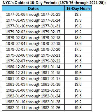
-

February 2026 Medium/ Long Range Discussion: 150K Salary Needed to Post
Ji replied to Weather Will's topic in Mid Atlantic
Remarkable turnaround -
Ensembles give me hope. Could be foothills and mountains special
-

Winter 2025-26 Medium/Long Range Discussion
Baum replied to michsnowfreak's topic in Lakes/Ohio Valley
The great VD storm of 2026 has yet to show its face. -

Winter Storm Threat *Technical* Discussion. No Op Run PBP or Snow maps
WEATHER53 replied to CAPE's topic in Mid Atlantic
It has been so much fun in last two weeks to post actual, real weather events, outcomes, obs and discussions . It’s really what got these weather boards underway back in the day. 240-360 hour explosions over models is boring and generally futile and discouraging. But it was mostly the only thing going for years. This year we had winter weather!! -
Transient high lowers the likelihood but winter has been winter this year, so why not? Been a long time since I’ve seen wet cement falling.
-

Winter 2025-26 Short Range Discussion
frostfern replied to SchaumburgStormer's topic in Lakes/Ohio Valley
How is a random stranger to know? As for toughness, how would you know? You run away from the cold. -

Winter 2025-26 Medium/Long Range Discussion
mimillman replied to michsnowfreak's topic in Lakes/Ohio Valley
Zzzzzzz -
Agreed. The duration of cold and snow cover making it feel like a real classic winter as long as we just put our phones down and take it all in. I’d give it a B- at least. But based on vibes and tracking, I feel last winter was more fun.
-
We can... but it doesn't mean "We do"
-
I don’t think we’re gonna crack freezing here. 31.4 and hasn’t moved in an hour
-
Winter 2025-26 Short Range Discussion
frostfern replied to SchaumburgStormer's topic in Lakes/Ohio Valley
Just stick to the larger cities. -
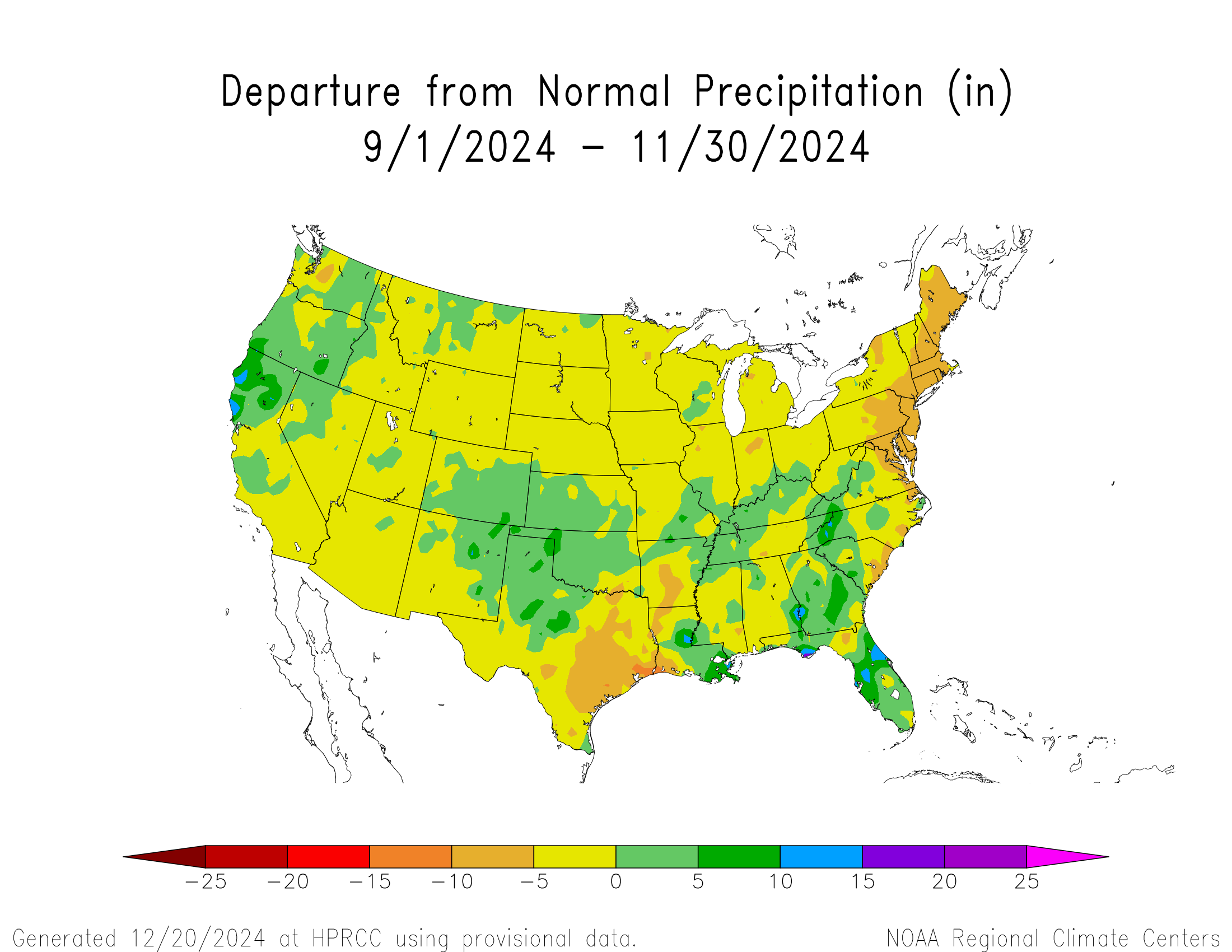
The higher ratios helped us out this winter with our snows since we have been continuing with this drier pattern since the fall of 2024.


-
To each …… his own …... As always …. .

-
Pretty snowy EPS run overall. Has more chances after the 16th too. Mean is double digits across a lot of New England. It’s not a frigid pattern but it’s just not submitting to the classic Feb Niña torch idea that has been an instinct to gravitate towards for many of us Mets. It’s a real struggle to get sustained large positive departures on these runs. You’ll see a run or two that starts to look like that but then it disappears the next run or even on the same run it can’t last more than a day or two. The in-situ blocking seems to dominate us locally while the plains have an easier time getting big warmth.
-
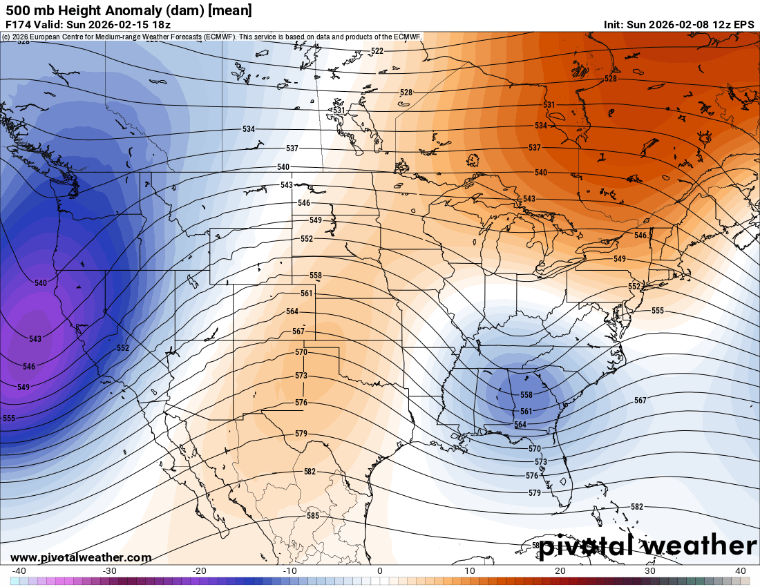
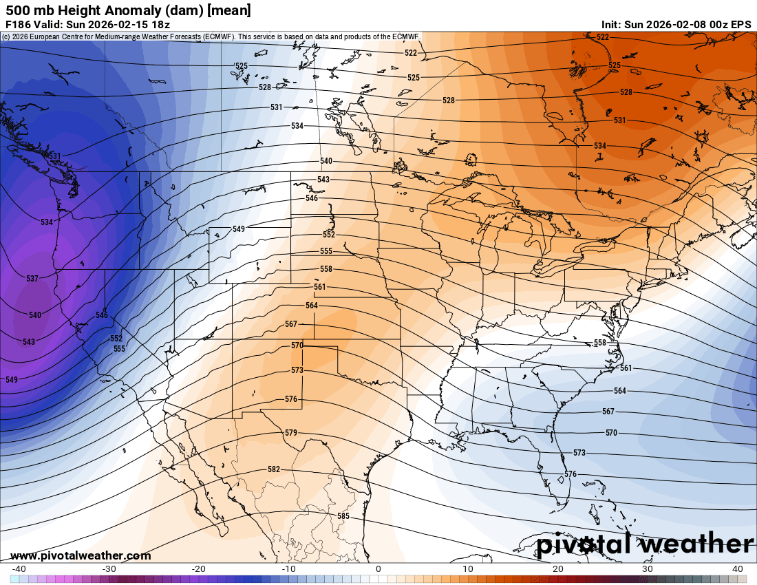
 Seeing the EPS mean is reassuring. The op runs can be expected to windshield wiper around the ensemble means, as they trend closer to the final solution, which we will have a better idea by Wednesday Upon closer inspection, EPS (and AI EPS) has reversed its weakening trend and re-strengthens the s/w on approach. Hudson bay high and confluence also stronger, better cold air mass. New run: Old run:

-
Don, what would be the one before 1982? Just wondering.