All Activity
- Past hour
-
Is it supposed to get hot later in the week?
-
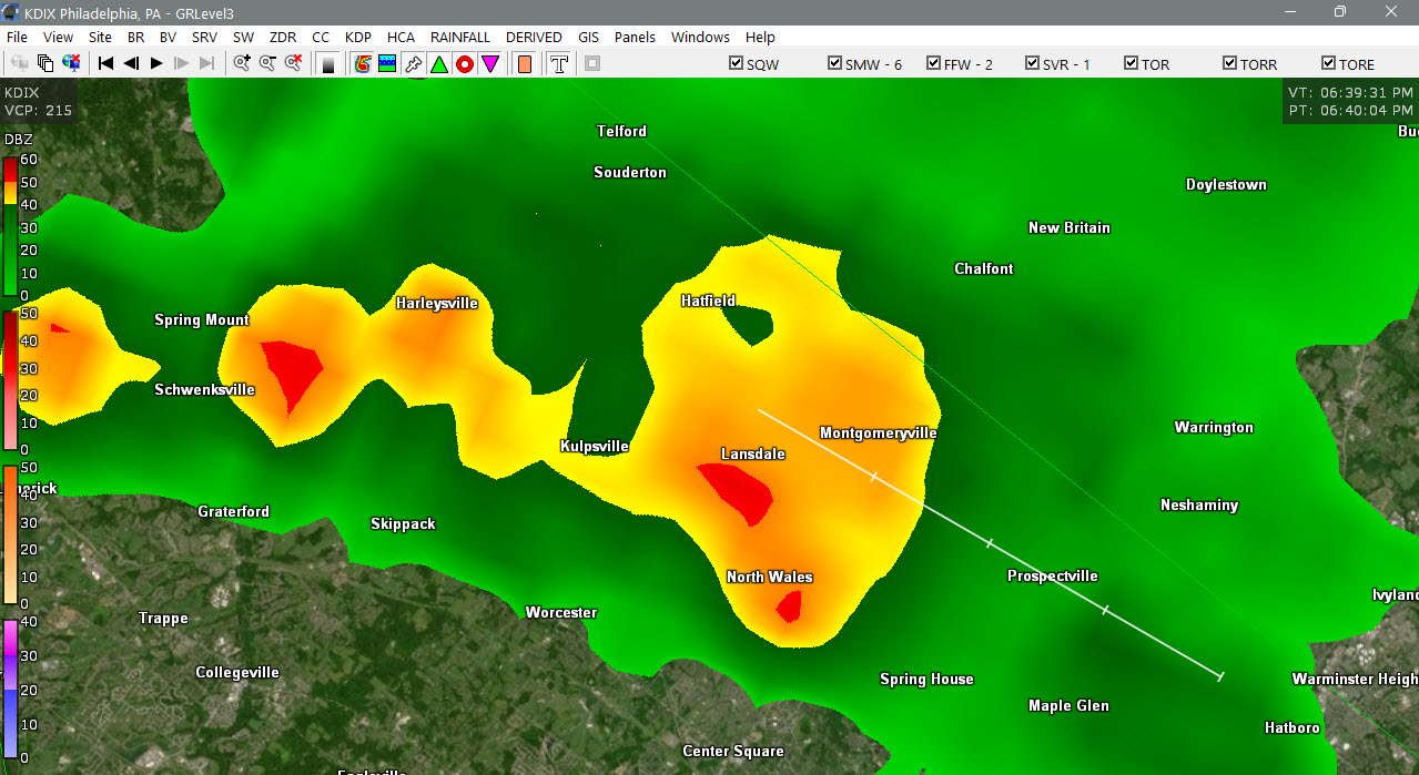
0.12” today/Columbia
-
The issue on Friday is that the ridging aloft is still almost right over us w/ very warm 700 mb temps. This is not conducive for convective development as things are capped. Any storms that manage to develop will just collapse on themselves due to very light winds aloft. Sat and after is better for tstms here. You can't treat a single convective parameter in a vacuum and run w/ that. Other things have to be present for tstms to develop and sustain. Using the K-index like this is like saying b/c there is a lot of CAPE, that means there will storms. Many days there is lots of CAPE, and nothing happens for various reasons. For the K-index itself, it is probably best for forecasting heavy rainfall potential as it indicates a solid moist vertical profile 700 mb and below. Also. an axis of higher indices often indicates a boundary present that may not show up on other analyses. K-index though in a solid svr wx environment often is low owning to dry air at mid-levels. Dry air at mid-levels actually tends to be better for svr wx overall as it can mean an EML is present.
- 871 replies
-
- 1
-

-
- severe
- thunderstorms
- (and 7 more)
-
don’t waste your keystrokes responding to that troll. he does not post in good faith, never has.
-

E PA/NJ/DE Spring 2026 Obs/Discussion
BBasile replied to PhiEaglesfan712's topic in Philadelphia Region
And on Thursday... GFY ECM.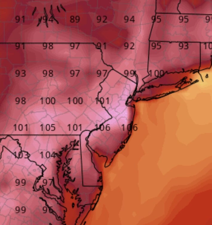
-

E PA/NJ/DE Summer 2026 Obs/Discussion
JTA66 replied to PhiEaglesfan712's topic in Philadelphia Region
Approaching 1.00” -
High of 92 before the rains came. Picked up another 1.02" today from 3 different storms.
-
Pretty much all of falls lake got 1.5-2.5+” today. Currently a flood advisory. Excellent!!!
-
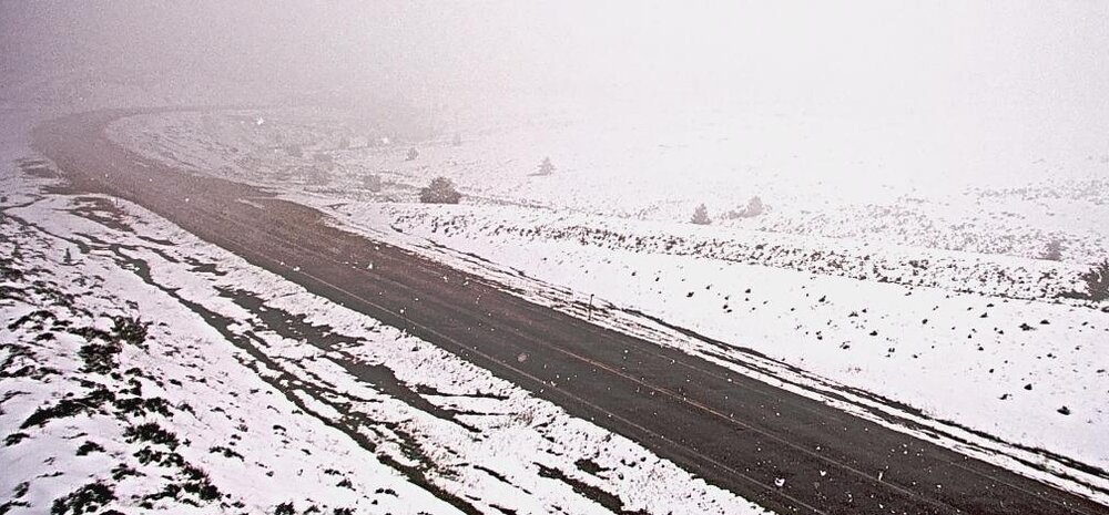
Big Hole Pass, MT, ~7400'
-
https://x.com/TonyPannWBAL/status/2071349776344351200 Tony Pann @TonyPannWBAL Big Boomers over the top of the Heat Dome later this week? Below you'll see a plot of the "K Index" from the Canadian GDPS. It's a measure of T-Storm potential. Anything 40+ is good. You can see the bullseye (red) on Thursday is well North of MD. By Friday, that 40+ zone sinks into MD. Stay tuned...
-

E PA/NJ/DE Summer 2026 Obs/Discussion
Birds~69 replied to PhiEaglesfan712's topic in Philadelphia Region

-

2026-2027 Super El Nino
LakePaste25 replied to Stormchaserchuck1's topic in Weather Forecasting and Discussion
Where are you seeing an EWB? Do you have any charts showing it? -
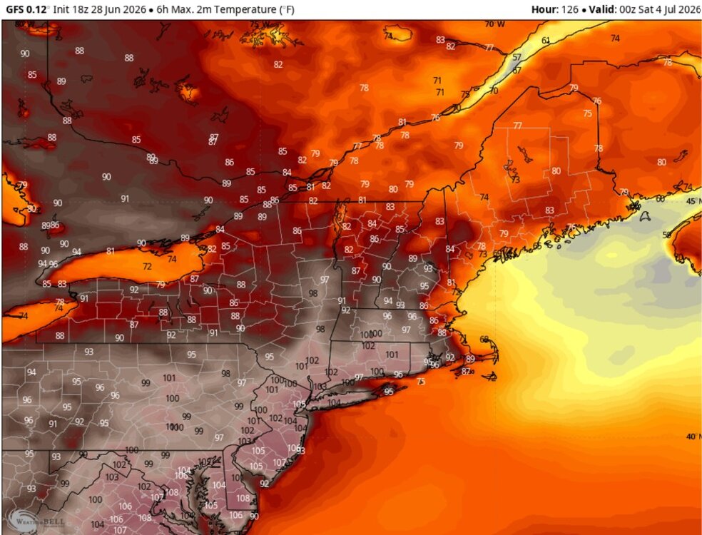
I have been looking at the GFS and Euro on Weatherbell. The maximum 6 hour temperatures for later this week. Lots of 100 to 105F in the major cities. Ouch, a 108F in DC. I think this is the day of maximum heat but Boston cools down with a seabreeze. Also of note but I didn't post is the crazy minimums in some of the major cities. It's going to be tough to get down below 80F in places like NYC to DCA.
-
E PA/NJ/DE Summer 2026 Obs/Discussion
JTA66 replied to PhiEaglesfan712's topic in Philadelphia Region
It is absolutely pouring here. - Today
-
Just had another round of rain but the worst of the flooding has receeded. Plenty of neighborhoods near creeks were under 3 to 4 feet of water, and a highway is closed due to a rock slide. The main creek near my house rose around 8 feet in about as many hours. It was basically in a low to almost no flow state through one opening and around 12 inches deep where it goes under the bridge. Now it's flowing through all three openings and it's around the 9 feet deep mark. There was a fairly large area of Morgan, Scott, Campbell and areas just south/east that got 6-8 inches of rain.
-
18z gfs brings the E taint late Fri into Saturday…especially eastern zones. Def gotta watch for that as the ridge relaxes just a bit and a weak s/w rounds it to our NE. Still a scorchah on Thu
-
E PA/NJ/DE Summer 2026 Obs/Discussion
JTA66 replied to PhiEaglesfan712's topic in Philadelphia Region
From the “you can’t make this $hit up dept”, I’m under a passing shower. I’ll probably end up with more rain today (our rain-free day) than I did on our rainy Saturday. -

Junorch obs and discussion 2026
Damage In Tolland replied to Damage In Tolland's topic in New England
That cell is a monster . Looks like a few inches . Tourney delayed till tomorrow -
A little over 2 inches of rain over the past day. The forest floodplains in the neighborhoods I walked had some minor flooding.
-
I will be super impressed if a location out near Montauk can put up 101°.
-
This may be a stupid question, so forgive me if it is, but what's with the fog coming in from Revere beach? Is it because of the cooler water temps and the airmass moving over to land?
-

Junorch obs and discussion 2026
CT Valley Snowman replied to Damage In Tolland's topic in New England
Traveler's championship final round in Cromwell CT getting screwed with a nearly stationary downpour. -
Yup, and don't even get me started, LOL!! I had to seriously restrain myself from making too "overly political" of a comment with my DOGE remark! But damn, I have been utterly pissed off (and worried) the past year and a half, it's hard NOT to make at least some reference to the reality going on.
-
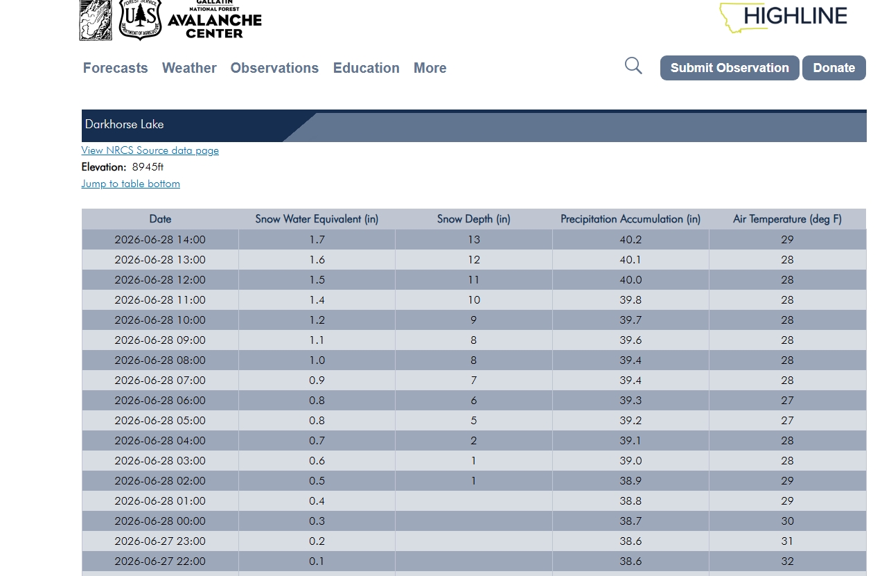
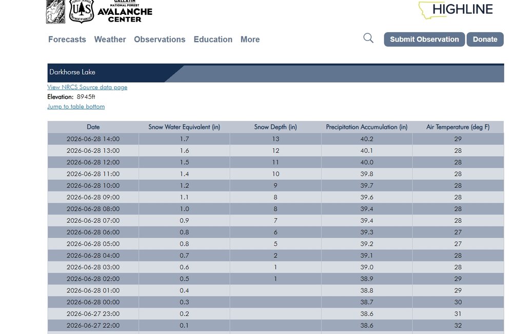
Some crazy weather for sure, snowfall already exceeding 12 inches out in western MT for this time of year----even for the higher elevations..
-
Congratulations. I hope all goes well.