All Activity
- Past hour
-
 I do think this will act a little more backdoor on Saturday, which is going to limit convergence along the boundary vs a traditional cold front.
 -
Day 3 and 4 SLGT up
-
103 was the high here. Down to 101 now
-

E PA/NJ/DE Summer 2026 Obs/Discussion
MGorse replied to PhiEaglesfan712's topic in Philadelphia Region
100 here with the heat index peaking at 115 thus far. Beautiful. -

Central PA Summer 2026 Discussion/Obs Thread
canderson replied to Voyager's topic in Upstate New York/Pennsylvania
MDT up to 101 -

Central PA Summer 2026 Discussion/Obs Thread
TheDreamTraveler replied to Voyager's topic in Upstate New York/Pennsylvania
Holy shit it's 103 right now. That's right on the cusp of a top 10 hottest ever for here. -
IAD back to 99° . . hope they make it!
-
 JTWC is forecasting tropical storm Bavi to pass directly over Saipan and Tinian in a few days as a 160 mph typhoon. I really hope the track changes. Typhoon Sinlaku just caused over $1.5 billion in damage to Saipan and other islands in April.
 -
 EWR 104
 -
97/81 on the Bush River
-
My apologies if posted already re Saturday URGENT - WEATHER MESSAGE National Weather Service Baltimore MD/Washington DC 132 PM EDT Thu Jul 2 2026 DCZ001-MDZ004>006-008-011-013-014-016>018-503>508-VAZ037>040-050-051- 053>057-501-502-505-506-526-527-030300- /O.UPG.KLWX.XH.A.0002.260704T1400Z-260705T0000Z/ /O.NEW.KLWX.XH.W.0004.260704T1400Z-260705T0000Z/ /O.CON.KLWX.XH.W.0002.000000T0000Z-260703T0000Z/ /O.CON.KLWX.XH.W.0003.260703T1400Z-260704T0000Z/ District of Columbia-Frederick-Carroll-Northern Baltimore-Cecil- Southern Baltimore-Prince Georges-Anne Arundel-Charles-St. Marys- Calvert-Northwest Montgomery-Central and Southeast Montgomery- Northwest Howard-Central and Southeast Howard-Northwest Harford- Southeast Harford-Albemarle-Greene-Madison-Rappahannock-Orange- Culpeper-Fairfax-Arlington/Falls Church/Alexandria-Stafford- Spotsylvania-King George-Northern Fauquier-Southern Fauquier- Western Loudoun-Eastern Loudoun-Northwest Prince William-Central and Southeast Prince William/Manassas/Manassas Park- 132 PM EDT Thu Jul 2 2026 ...EXTREME HEAT WARNING REMAINS IN EFFECT UNTIL 8 PM EDT THIS EVENING... ...EXTREME HEAT WARNING REMAINS IN EFFECT FROM 10 AM TO 8 PM EDT FRIDAY... ...EXTREME HEAT WARNING IN EFFECT FROM 10 AM TO 8 PM EDT SATURDAY... * WHAT...Dangerously hot conditions each afternoon with heat index values between 110 to 113 expected. * WHERE...Portions of DC, central, north central, northeast, northern, and southern Maryland, and central, northern, and northwest Virginia. * WHEN...For the first Extreme Heat Warning, until 8 PM EDT this evening. For the second Extreme Heat Warning, from 10 AM to 8 PM EDT Friday. For the third Extreme Heat Warning, from 10 AM to 8 PM EDT Saturday. * IMPACTS...Heat related illnesses increase significantly during extreme heat and high humidity events.
-
 Man, this 12z Euro bidness would make today seem like COC if it ever got kicked outta the west
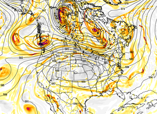
-
First hot day I can remember where there’s not a cloud in the sky. Impressive
-
 98-100F along the I 395 corridor, the Seabreeze is visible on radar, pushing up from the southern coast; we’ll see what that does to knock down temperatures in the next couple hours
 -
 Okay, that makes more sense. Thanks
 -
Water temp in my pool is up to 87° Concrete deck around the pool is 137.5°
-
They did not.
-
I'm not sure why our heat advisory hasn't been an extreme heat warning. We hit a heat index of 108 yesterday and 110 so far today. I think that's above the advisory level.
-
Heat index.
-
 Think BDL hit a Hundy between obs. One of those that quick hits that they don’t catch immediately
 -
 Yeah RadarScope does HI. I’m not a fan when I see those.
 -
 It's so fooking hot out but ok a tad less humid than yesterday but l imagine that changes this evening 99 here at the ranch and not too breezy
 -
Newark has hit 104 while JFK topped out at 102.
-
101/72/111.5 Not bad. This brings back memories of 3 years in India in the early 90s (when I was skinny and could dissipate heat better!). We had weeks of 113-118F temps with sultry humidity, which put the HI off the normal charts here in the US. Made us wonder why in the migration of homo sapiens did they ever stop there and not keep moving to a more tolerable climate.


