All Activity
- Past hour
-
47 now. No rain yet.
-
Some of the strongest backdoor cold fronts on record in the Northeast during April have occurred following record warmth. https://www.wunderground.com/history/daily/us/ma/east-boston/KBOS/date/2002-4-17 PM 93 °F 51 °F 24 % W 18 mph 23 mph 29.83 in 0.0 in Mostly Cloudy 4:54 PM 93 °F 49 °F 22 % W 17 mph 26 mph 29.82 in 0.0 in Partly Cloudy 5:54 PM 91 °F 49 °F 23 % W 14 mph 0 mph 29.82 in 0.0 in Mostly Cloudy 6:32 PM 66 °F 50 °F 56 % NNE 26 mph 33 mph 29.87 in 0.0 in Mostly Cloudy / Windy 6:54 PM 59 °F 50 °F 72 % NNE 25 mph 35 mph 29.91 in 0.0 in Cloudy / Windy 7:54 PM 55 °F 49 °F 80 % ENE 7 mph 0 mph 29.95 in 0.0 in Mostly Cloudy 8:54 PM 55 °F 50 °F 83 % N 8 mph 0 mph 29.96 in 0.0 in Partly
-
this would be fatal to the dome, right?
-

80 Degrees to Ripping Snow: March 12th
midatlanticweather replied to SnowenOutThere's topic in Mid Atlantic
Basically, had a heavy shower that made things go to all sleet and even some slush balls, but as soon as it got lighter it went back to rain with some sleet and now just light rain with an occasional pinger. So, type of precip seems rate dependent which makes sense. Close to 38..was a bit cooler in the heavy precipitation -
I feel your pain. At least you turned around and got something. We were close for Pontiac and saw ground circulation. By time we saw storm was planting a big one we were too far west. I will forever regret that decision.
-
I'm down at the Executive Office Building and yes it's a legit snow sleet mix. Incredible.
-
Candidate for post of the year !!!
-
06z GFS does look relatively wintry. Has a clipper next week and a little critter coastal in clown range
-
I’m issuing a puddle warning for Frederick. Guys, be careful out there.
-

E PA/NJ/DE Spring 2026 Obs/Discussion
PhiEaglesfan712 replied to PhiEaglesfan712's topic in Philadelphia Region
Pingers??? I guess this means Free Agency has begun, and it's Eagles season again. -
Got a few pingers in Columbia.
-
That was a monumentally shitty post, and we've had enough shitty posts in here over the years to be able to spot them!
-
Down to 39.9. Still a rain/sleet mix but more sleet now in the mix.
-
Bye bye remaining mounds of snow. There were still some stragglers, but this rainstorm has finished them off.
-
Yup getting a wintery mix here on Smokey park hwy. Snowing at home per reports. Not sticking but Snowing.
-

Central PA Spring 2026 Discussion/Obs Thread
canderson replied to Voyager's topic in Upstate New York/Pennsylvania
Pretty concerned with the 2”+ rain and tomorrow very strong winds. Could see some trees fall. -

80 Degrees to Ripping Snow: March 12th
WesternFringe replied to SnowenOutThere's topic in Mid Atlantic
38 degrees and ripping fatties in Augusta County! Starting to accumulate in the woods and pavement by the tennis courts and the top of cars.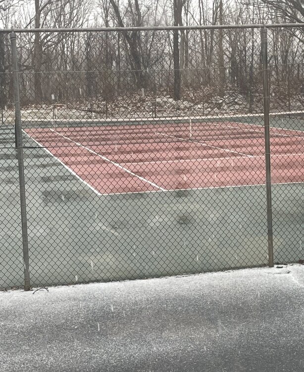
-
We have this debate EVERY TIME there is a projected snow after a cold front and its exhausting. I've been out west and seen snow accumulate after an 80 degree day multiple times! It doesn't happen here as often for several reasons but that doesn't mean it can't. Unlikely and impossible are two very different things. And just because something has not happened does not mean it can not happen. One thing that has to be factored in, is it does not get to 80 that often during the winter, so the opportunity for this to happen would be limited so the fact it has not happened might just be limited sample size not a function of it being impossible. As we see more extreme temperature swings happening this kind of thing might become more common. It matters what the temperature is WHEN it's snowing...not the day before!
-
-
Honestly the orientation if nothing else of the precip on the models reminds me of some dynamic spring systems. Definitely eyebrow raising to get a Day 5 15%. I'm still not convinced it will be anything substantial, though. We'll see how it looks in NAM range.
-

80 Degrees to Ripping Snow: March 12th
Skywalker03 replied to SnowenOutThere's topic in Mid Atlantic
Sleet and snow now mixing in here in Rockville -

Central PA Spring 2026 Discussion/Obs Thread
anotherman replied to Voyager's topic in Upstate New York/Pennsylvania
Not anymore -

-
every spring i read posts about a bad season for backdoor fronts yet our last cold april was 6 years ago
-

80 Degrees to Ripping Snow: March 12th
nw baltimore wx replied to SnowenOutThere's topic in Mid Atlantic
Sounds like some sleet mixing in here in Pikesville.


