All Activity
- Past hour
-
Remember what Carver said yesterday. Be nice...
-

Possible Record Breaking Cold + Snow Sunday 1/25 - Tuesday 1/27
NittanyWx replied to TriPol's topic in New York City Metro
Risk here is primary handoff to coastal and slotting. I think coastal areas, especially Jersey and ELI have a period of sleet, but the slotting on Monday with primary handoff is a tricky feature. Should still be a very soli event, just a mater o top end -

“Cory’s in LA! Let’s MECS!” Jan. 24-26 Disco
LSC97wxnut replied to TheSnowman's topic in New England
Guess NWS-Boston has seen enough, Watches are up. -
The 540 critical thickness was more important in forecasting in the 1990s when we were more limited on the model data we received. It’s definitely outdated now. Usually it can snow even with a 552dm thickness in these overrunning SWFE setups.
-
The weekend storm could be one of the most widespread we have had in a while. Some pretty large totals from icon and Canadian runs. Will be interesting once we get into short range to see if the lake will add on anything additional.... though most likely frozen by then.
-
Im heading up to VT this afternoon. Was supposed to come back sunday but I'll wait things out until Monday afternoon. I feel like we're in the window of the run up to a storm where people are nervous and pointing to everything that could go wrong. Then tomorrow the storm thread will start with "this a nowcasting event". As if that isnt true of every event.
-

“Cory’s in LA! Let’s MECS!” Jan. 24-26 Disco
weatherwiz replied to TheSnowman's topic in New England
This is why I can't wait until we get into meso model range. The mesos I think should handle this very well and this is when we can really talk about the potential for >15" totals and where those would be most likely to occur. -
There's going to be sleet. Especially here in AA county. The question is: how much sleet? GFS says not a lot, every other model has substantially more. GFS is probably going to cave, but its not certain. We're still three days out. Better confluence up top will lead to a more GFS-like solution
-
I ended up with several inches of sleet here from this one on top of 3" of snow. https://www.raymondcmartinjr.com/weather/2007/14-Feb-07-SurfaceMaps.html
-
I like this one for the Eastern areas. A one two punch coming up seems a good bet.
-

January 24-26: Miracle or Mirage JV/Banter Thread!
Kay replied to SnowenOutThere's topic in Mid Atlantic
Sounds like you enjoy it and it's part of your weenie-ing out vs just a sense of duty, which I respect haha I like being out in it, too, but walking and stuff more so than shoveling -
Mods are probably starting to pick up on downsloping .
-
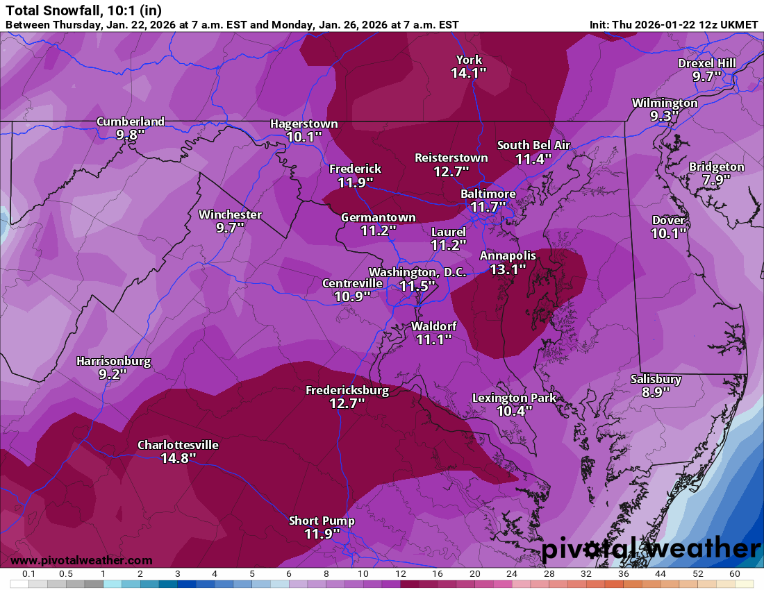
If this turns into widespread 10-12" you hope there won't be a lot of disappointment here In the next few days I'll be watching out for drying midlevels showing up, especially if the trough keeps trending west. As mentioned if it goes the other way and you start seeing mesobands and mid-level magic or ivt snows then we'd start to push the expectations up. 2/5/14 was widespread 10-14" even down to DC and it was an awesome storm. Just hope a redux of that wouldn't be considered a fail.
-

Richmond Metro/Hampton Roads Area Discussion
Conway7305 replied to RIC Airport's topic in Mid Atlantic
Ukie
-

Central PA Winter 25/26 Discussion and Obs
Voyager replied to MAG5035's topic in Upstate New York/Pennsylvania
I'm not sure I want a trend so much as for it to hold serve just as it is. Everyone gets close to, or even above 20" as depicted. I'd kind of hate to lose what I (or we) have gained the past few runs. -

January 24-26: Miracle or Mirage Thread 2
SomeguyfromTakomaPark replied to mappy's topic in Mid Atlantic
This is a QPF bomb so it is possible we get a foot of snow AND a ton of sleet. If we change over quicker maybe 6-8 inches and then sleet. Nothing is showing less than 6 inches of snow before a changeover. The later the changeover, the more we can pile up. -
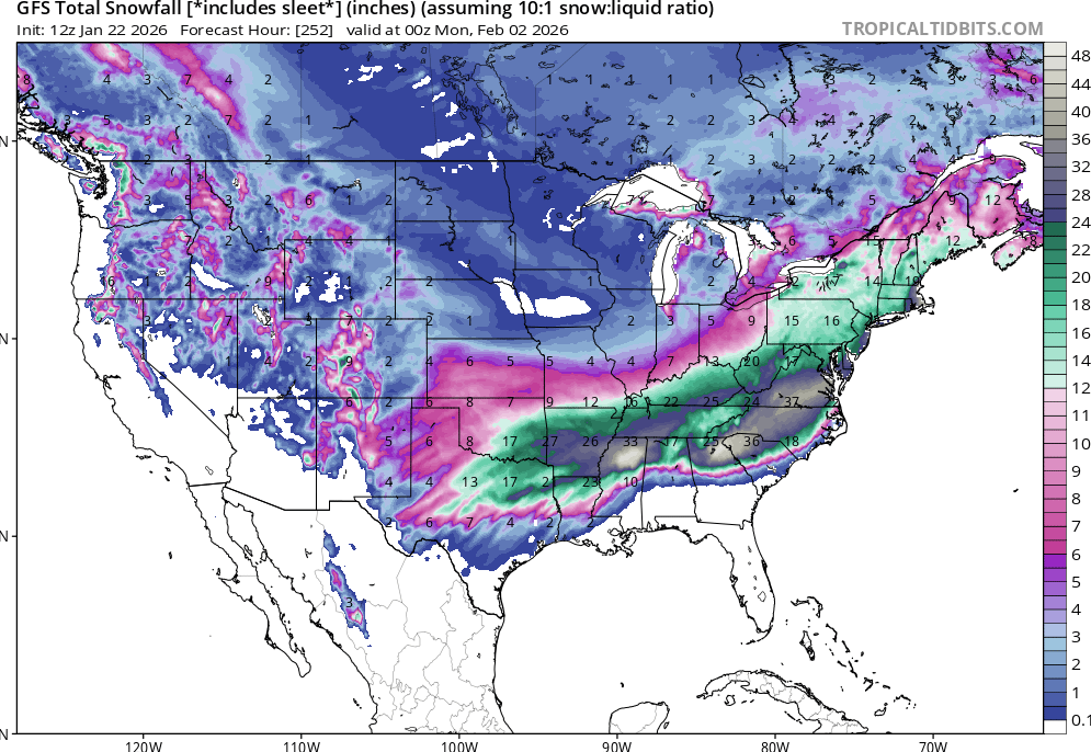
Almost every single piece of guidance has the 84 corridor 12-18” but like a few have already said it’s a biggie but not a true monster like the Snowicane etc. I do think the next 10 days does have the potential to be something historic.
-
GFS shows a blizzard for next Sunday, Cmc shows snow and than a blizzard coming up the east coast by next sunday! This is a real winter!
-
Since I punted the current setup over the last 24 hours, I've been watching it. The signal is there, but it's a LONG way out. Back to a 8+ day track. It's what we do... lol
-

January 24-26: Miracle or Mirage JV/Banter Thread!
WxUSAF replied to SnowenOutThere's topic in Mid Atlantic
Great write up in the varsity thread @MillvilleWx! I think the cold temps during and after the storm are going to low key be really surprising and impactful. Just zero melting. -
Except for now the EURO and GFS agree which makes it seem more lkely to happen
-

January 24-26: Miracle or Mirage JV/Banter Thread!
AlexD1990 replied to SnowenOutThere's topic in Mid Atlantic
lol the board would crash if the GFS is right about a follow up storm next week -
That's GFS and GEFS, UKIE and Euro are more like 10-11, ICON and NAM are closer to 8-9.
-

Possible Record Breaking Cold + Snow Sunday 1/25 - Tuesday 1/27
SACRUS replied to TriPol's topic in New York City Metro
Updated -

Winter 2025-26 Medium/Long Range Discussion
A-L-E-K replied to michsnowfreak's topic in Lakes/Ohio Valley