All Activity
- Past hour
-
At the very least, There is some systems in the pipeline.
-

First Winter Storm to kickoff 2025-26 Winter season
tamarack replied to Baroclinic Zone's topic in New England
GYX 90/50/10 percents for Farmington (and here) are 0.5"/7"/14". Guessing that the models remain far apart. P&C forecast is 3-5 tomorrow and 2-4 tomorrow night. -

December 2025 regional war/obs/disco thread
SouthCoastMA replied to Torch Tiger's topic in New England
Yeah looked a bit better with those clippers post 12/8 -

Occasional Thoughts on Climate Change
WolfStock1 replied to donsutherland1's topic in Climate Change
Nope. Read the links I posted for actual numbers. As of 2022 renewable energy comprised 53 percent of all energy subsidies. This includes tax incentives. And this despite renewables only being 21% of production. https://www.instituteforenergyresearch.org/fossil-fuels/renewable-energy-still-dominates-energy-subsidies-in-fy-2022/ You can keep repeating the "when all financial factors" canard all you want, but it doesn't make it true. -

12/3 Snow/Sleet/Mix Bag of Everything Discussion/OBS
Birds~69 replied to Mikeymac5306's topic in Philadelphia Region
You can only name one? This storm reminds me of every storm... -

December 2025 regional war/obs/disco thread
H2Otown_WX replied to Torch Tiger's topic in New England
If by several you mean 22 then yeah. -
Well, not looking so good now. They've all lost it. We shall see!
-
 It would be hard any time of year for this to be snow at the coast when we have strong onshore flow to deal with as the storm comes in, maybe if we had a significantly colder leading airmass. You can see clearly how the fairly marginal cold retreats as the storm moves in. If the high could hang on we would have a chance but again the fast progressive pattern bites us. Storm is also gone before it can fully mature at the mid levels, so we don’t get a CCB to form and cold air to work back in.
 -
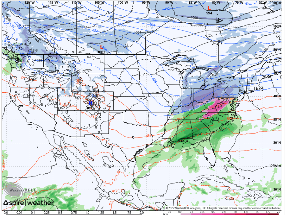
Wxbell model Spire only because it says it on the lower left corner
-
Models barely holding on to snow here, with no breathing room left. Morning runs for my yard: 6Z ECMWF- 2.0” (10:1) 12Z GFS- 3.5” (Kuchera) 12Z CMC- 5.5” (10:1) 12Z RGEM- 5” (10:1) 12Z UKMET- 3.5” (10:1) 12Z NAM 12km- 2.5” (10:1) 12Z NAM 3km- 1.5” (10:1)
-

First Winter Storm to kickoff 2025-26 Winter season
ineedsnow replied to Baroclinic Zone's topic in New England
Still thinking 6 to 9 unless this warms more -
First Winter Storm to kickoff 2025-26 Winter season
H2Otown_WX replied to Baroclinic Zone's topic in New England
Welp, this aged poorly :/ -
At this point I’m tracking Friday’s cold temps. Looks like mid-upper teens for the area Friday morning, with highs possibly below freezing.
-
Something that has been missing over the past several years are the alberta clippers but the GFS has some modeled going forward.
-

First Winter Storm to kickoff 2025-26 Winter season
WinterWolf replied to Baroclinic Zone's topic in New England
Ya…he thought 2-4” anyway. Heh, these models can jump back the other way a tad too..so it ain’t a done deal yet. -
 Yes. Based on 12Z data my 2-4" forecast is in trouble. Gonna let it roll and see how things unfold with 18Z guidance and update this evening if necessary. Worried though about the 2-4" forecast.
 -
Figured snow pictures were better than window ac and climate change talk, lol. .
-

First Winter Storm to kickoff 2025-26 Winter season
CoastalWx replied to Baroclinic Zone's topic in New England
He was talking Snow in his backyard yesterday. -
 I don’t think this is a case of that. (No, I’m not denying AGW; Yes, I believe it is occurring.) I think it’s more of a case of very early December and it just doesn’t happen that often at this time of year, especially in an enormous, concrete-heavy, oceanfront city. Sometimes things just happen. .
 -

2025-2026 Fall/Winter Mountain Thread
BlueRidgeFolklore replied to Buckethead's topic in Southeastern States
Welcome! Sounds like you're near the Bat Cave / Bearwallow Mountain area. Bearwallow has been known for some good winter weather from time to time. Funny you mentioned the Mid-Atlantic forum, that was my first introduction to AmericanWx as well. Spent the 2010 Snowmageddon/Snowpocalypse blizzards in the DMV when I was in the Navy. Fun times! Welcome to the mountains, hopefully you brought the winter weather mojo with you! -

First Winter Storm to kickoff 2025-26 Winter season
Snowcrazed71 replied to Baroclinic Zone's topic in New England
Wow, this one was fun to track, but all over the place. Not to give Kevin a big head, but I have to give him credit. He's stuck to his guns from the beginning. I'll be happy if I get an inch. Not too disappointed, as it's early and I don't usually see much snow around this time frame. I would start getting more anxious by the middle of the month. But even then, as we say for the last several years, we still have January, February and March. Hopefully we'll look back on this conversation by March and say what a winter it was! -
I gotta say, I'm not really paying attention to the models this year and it's been less stressful. Just using the ole weatherbug app has simplified my life.and generally been more accurate.
-

Central PA Fall Discussions and Obs
Storm Clouds replied to ChescoWx's topic in Upstate New York/Pennsylvania
York and Lancaster counties are ALWAYS the southern edge…ALWAYS! Like what even is that? GFS has 6 inches here and the NAM has barely an inch lol -
36° w/ lots of sunshine currently. I do think Orange goes to a warning for 4-8". WWA for Rockland & W Passaic for 2-3". Once you cross the Hudson south of the Putnam/Westcher border is prob primarily a rain event with some snow to start. I-84 is the new "NW of 287" line
-
Okay, this one you'll have to guess based off the output. (for some reason I can't zoom in onto the Mid-Atlantic with this model)