All Activity
- Past hour
-

Central PA Summer 2026 Discussion/Obs Thread
Itstrainingtime replied to Voyager's topic in Upstate New York/Pennsylvania
Gulp - (from Elliott at MU) After a mainly clear and mild Saturday night, winds will turn southerly Sunday morning and bring more humid air back into the region. Another cold front will sweep through the Commonwealth from Sunday afternoon into Sunday night, interact with the very warm and unstable air mass in place, and spark widespread showers and thunderstorms. The upper-level energy supporting Sunday's front will also be much more vigorous and organized than this afternoon's and on a southwest-to-northeast trajectory across the region. Meanwhile, winds in the mid- and upper-levels of the atmosphere will generally be westerly, so there will be sufficient, deep-layer directional and speed wind shear for tornado formation. I don't expect a tornado outbreak or major, long-track tornadoes, but a few to several twisters are a real possibility in northern MD, southeastern PA, and the Lower Susquehanna Valley. In addition, the most intense storms will likely contain damaging wind gusts up to 65 mph, quarter-sized hail, frequent lightning, and localized flash flooding. The atmosphere will be sufficiently moist and unstable with temperatures and dewpoints in the 80s and mid-to-upper 60s, respectively, for rapid thunderstorm development and growth. As such, rainfall rates may easily reach 2" per hour in many of the storms, but rainfall amounts will vary greatly from neighborhood-to-neighborhood and county-to-county. They may "average" around 0.50" for the region, but some "jackpot" locations may receive up to 2.0-2.5". Regardless, I expect widespread incidents of downed trees and power lines, roof and vehicle damage, and perhaps worse on Sunday. The drive to-and-from Sunday morning church services should be fine, but the weather will turn downright volatile and dangerous Sunday afternoon between ~2-10 PM. If possible, stay inside during that time and seek shelter in an interior room or basement if a severe thunderstorm or tornado warning is issued. In terms of severe weather, Sunday has the potential to be the worst day of the year up to this point. -
We thank you in advance for your sacrifice.
-
https://www.spc.noaa.gov/products/md/md1106.html
-
https://www.spc.noaa.gov/products/md/md1106.html
-
98F so far at DCA. Damn.
-
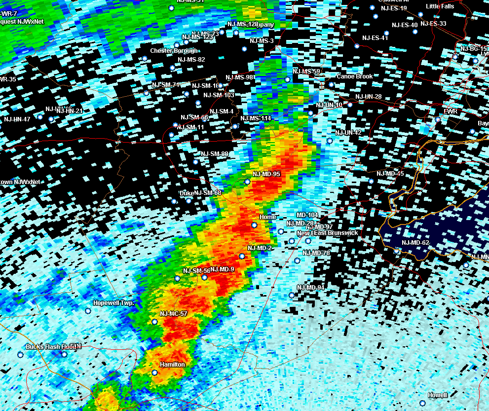
Yup. Lucked out with that one. Looked like the line was mostly collapsing (with occasional localized pulses), but strengthened just to my west and dropped an unexpected 0.44". Luck of the draw.

-
Watch coming soon per MCD sounds like Mesoscale Discussion 1107 NWS Storm Prediction Center Norman OK 1257 PM CDT Fri Jun 12 2026 Areas affected...much of Virginia...parts of West Virginia...Maryland...northern North Carolina Concerning...Severe potential...Watch likely Valid 121757Z - 121900Z Probability of Watch Issuance...80 percent SUMMARY...Scattered storms capable of damaging wind gusts are expected to develop through the afternoon. DISCUSSION...A surface trough is gradually deepening across MD/VA/NC with strong heating resulting in very steep low-level lapse rates. Modest northwest flow aloft exists into the area, which may aid in steering storms in a southeastward direction. Visible imagery shows a moist air mass across the entire area and extending west across the higher terrain as well, suggesting minimal drying/downslope effects. In the next couple hours, storms may form in the agitated CU area currently seen over northern into northwest VA. Several models depict a possible cluster of storms moving southeastward later today, with a corridor of damaging winds possible. Other storms are likely to develop over WV and southward across the Appalachians. Given the weak northwest winds aloft, any such activity may move into the lower terrain late in the day. Several models suggest any such convection and/or outflows may instigate new development during the later afternoon into much of central VA and perhaps northern NC. ..Jewell/Thompson.. 06/12/2026 ...Please see www.spc.noaa.gov for graphic product... ATTN...WFO...AKQ...LWX...RAH...RNK...RLX...GSP...MRX... LAT...LON 37258177 37808116 38787980 38987924 39137802 39027702 38927678 38377634 37847641 37517710 36987785 36397880 36018174 36018182 36368227 36798229 37258177 MOST PROBABLE PEAK WIND GUST...55-70 MPH MOST PROBABLE PEAK HAIL SIZE...UP TO 1.25 IN
- 596 replies
-
- 1
-

-
- severe
- thunderstorms
- (and 7 more)
-
89/70
-
40 % Chance of Severe Watch Being Issued SWO from KWNS
-
Is next week actually going to be BN, or just N?
-
Shop Davis 90F/73
-

E PA/NJ/DE Summer 2026 Obs/Discussion
RedSky replied to PhiEaglesfan712's topic in Philadelphia Region
The drought is about to cross the line into disaster for local farmers with this weekends debacle. I am around 1.80" for the last month after yesterdays trace and one tenth the one before that. If Sunday's chance fails it's over. -
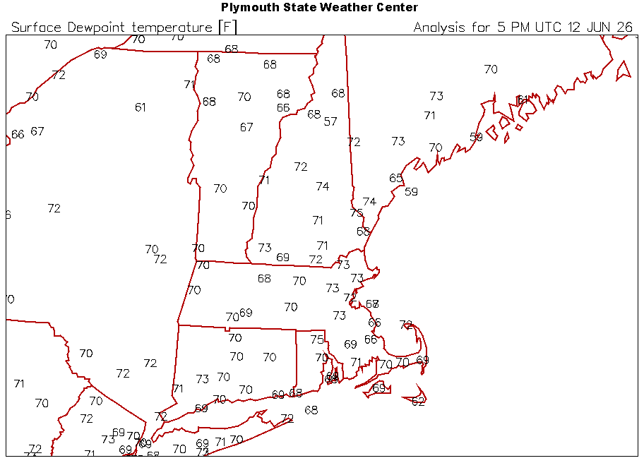
92 here currently. Dew Point 70 F Humidity 54 %
-
Highs early next week might be similar to our current dew points up here.
-

2026-2027 Super El Nino
snowman19 replied to Stormchaserchuck1's topic in Weather Forecasting and Discussion
-
Not sure if today is still a go for the storms or not. Everything that came along was south of here so far. If so, this will be the 3rd or 4th 80/90 percent rain chance day that was a total miss here in the last few weeks. That's way more than I can recall in such a short period.
-
The usual. Just north of us got the severe storm too.
-

Junorch obs and discussion 2026
CT Valley Snowman replied to Damage In Tolland's topic in New England
high of 89 so far but should hit 90 over the next hour. -

Mountain West Discussion
mayjawintastawm replied to mayjawintastawm's topic in Central/Western States
OK, for the mets out there: I saw something yesterday that I haven't seen or heard of before. There was an air quality alert for ozone, but it wasn't for the typical sun + stagnant air + vehicle exhaust combination. It was for a "stratospheric intrusion". The weather was stable and I don't think winds were that weird. What's that all about? -

super el nino banter thread
forkyfork replied to forkyfork's topic in Weather Forecasting and Discussion
maybe we can roni it down - Today
-

2026-2027 Super El Nino
FPizz replied to Stormchaserchuck1's topic in Weather Forecasting and Discussion
If you read the comments from the original poster of the video, there are pics from the 1950s of boats catching them in the same region. So it has happened before and reading other comments it doesn't seem like this is a very rare thing, but doesn't happen yearly. -
super el nino banter thread
forkyfork replied to forkyfork's topic in Weather Forecasting and Discussion
by this point in 1997 my area had two 90 degree days and so far this year we have 10 -
Even 74-75 dews at the airport sites up here. Still not installed yet either. Love it!
-
So annoying that it missed. My mom over in piscataway, due east of here, got a decent storm and lost power for a few minutes. Line reformed right after our town.
-
Absolutely


.thumb.gif.f92b16c631a1d15d405ed77b33f0710d.gif)