All Activity
- Past hour
-

E PA/NJ/DE Spring 2026 Obs/Discussion
Birds~69 replied to PhiEaglesfan712's topic in Philadelphia Region
If it wasn't for the blooming trees I would think it's Fall...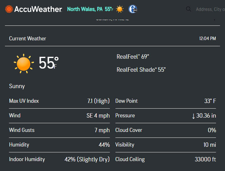
-

Spring 2026 Pattern Discussion Thread
KakashiHatake2000 replied to Carvers Gap's topic in Tennessee Valley
https://www.facebook.com/photo.php?fbid=1478461416980373&set=a.197292151763979&type=3&ref=embed_post I know this is for Alabama but looks like the southeast could be in luck . -
April 12 1931: July-like temperatures are felt across the area with 90 degrees at Beardsley in west central Minnesota. For Sunday, April 12, 2026 1927 - A tornado wiped out the town of Rock Springs, TX, killing 72 persons and causing 1.2 million dollars damage. The tornado, more than one mile in width, destroyed 235 of 247 buildings, leaving no trace of lumber or contents in many cases. Many survivors were bruised by large hail which fell after the passage of the tornado. (David Ludlum) (The Weather Channel) 1934 - Winds atop Mount Washington, NH, averaged 186 mph for five minutes, with a peak gust of 231 mph, the highest wind speed ever clocked in the world. (David Ludlum) 1987 - A cold front crossing the central U.S. produced heavy snow in the Central Rockies, and severe thunderstorms over Kansas and Oklahoma. Snowfall totals ranged up to 16 inches at Red Mountain Pass CO. Thunderstorm winds gusted to 87 mph at Ponca City OK. Winds associated with the cold front itself gusted to 69 mph at Tucumcari NM. (The National Weather Summary) (Storm Data) 1988 - Snow blanketed the Southern Appalachians. Totals in North Carolina ranged up to 17 inches at Mitchell. Winds at Flat Top Mountain gusted to 80 mph. (The National Weather Summary) (Storm Data) 1989 - Twenty-two cities in the south central and eastern U.S. reported record low temperatures for the date, including Elkins WV with a low of 15 degrees, and Baton Rouge LA with a reading of 37 degrees. (The National Weather Summary) 1990 - Arctic air invaded the central U.S. Lincoln, NE, reported a record low of 17 degrees. Thunderstorms developing along the arctic cold front produced heavy snow in north central Kansas, wind gusts to 61 mph at Midland TX, and wind gusts to 69 mph at Rawlins WY. Warm weather prevailed in the southwestern U.S. Las Vegas NV reported a record high of 91 degrees, and on the 13th, Sacramento CA reported a record high of 95 degrees. (Storm Data) (The National Weather Summary) 2010 - One-inch diameter hail falls in Fresno, CA. Two condominiums are destroyed by thunderstorms in California's San Joaquin Valley. Up to three funnel clouds were also seen in the region. Note: That wind speed record was eclipsed on April 10, 1996 with Tropical Cyclone Olivia in AUS with a wind speed of 254 mph. But the Mt Washington record still stands as fastest non cyclonic/tornadic straight line wind. These are anemometer records. The fastest was a Doppler on Wheels (DOW) radar sig with the 1999 Bridge Creek–Moore tornado between Oklahoma City and Moore, Oklahoma, 3 May 1999. Wind speed analysis of 321 mph.
-
The models seem (today) to be in good agreement on a good snowstorm for the foothills and Palmer divide on Friday. Hopefully, this one does not evaporate as we get closer.
-
You would’ve liked it in the 1500s when there was actually vegetation there.
-
You have a kid now. You’re going to appreciate the warm season doing more with your son. I’m telling you.
-
Chris, 1. The writeup you linked us to specifies what we already knew: the U.S. now incorporates RONI for its official ENSO updates vs the Euro still not doing so. So, to approximate RONI based on the current difference, ~0.5C should be subtracted from the Euro progs since they are still predicting a straight ONI. 2. The following shows that although the Euro’s too warm ASO ONI prog was highest for April progs in 2017 (+1.4), it was also significantly too warm in 2025 (+0.8), 2022 (+0.7), 2021 (+0.6), 2020 (+0.8), 2014 (+1.2), and 2012 (+0.6). Moreover, misses to the cold side were much less frequent and smaller. So, based on averaging out the misses, a notable warm bias is evident although it isn’t as large when El Niño actually verifies. None of this means ONI will definitely verify colder than the April Euro prog, but rather to not be surprised if it verifies several tenths colder based on a bias corrected ONI prog:
- Today
-
That’s good. .
-
I guess I was more tipsy than I thought yesterday. I just looked to see which WWS I purchased, but apparently I bought two 4 packs of the 120.
-

E PA/NJ/DE Spring 2026 Obs/Discussion
JTA66 replied to PhiEaglesfan712's topic in Philadelphia Region
That’s all you got? 57F/DP 35F -
This week will go a long way to getting our course open. I haven’t heard a projected opening date yet.
-
48/26, chilly today Last year I made it to June 1st before installing
-

E PA/NJ/DE Spring 2026 Obs/Discussion
Hurricane Agnes replied to PhiEaglesfan712's topic in Philadelphia Region
I know KYW heavily reported on that. it's the season in Jersey! CPC (or what is left of it) put out their last La Nina Advisory and has started an El Nino Watch - https://www.cpc.ncep.noaa.gov/products/analysis_monitoring/enso_advisory/ensodisc.shtml There was some historical data compiled for strong El Nino years to show general trends. The data goes back to the late '50s through to 2016 - https://www.ncei.noaa.gov/access/monitoring/dyk/el-nino As an obs, I bottomed out at 42 this morning and am currently a sunny 57 with dp 37. -
I already put away mine . I do have 3 jackets out just incase.
-
Worst
-
Still in a Nina, heading towards neutral.
-
Will the airports even hit 2” of precip for April??
-
Which WWS? The one they had at their store in Rehoboth was the Wake Up version from a few years ago. Its good and I bought some but I like the Triple Decadence better. Maybe they had it but I didn't see it in my inebriated state lol.
-
Juicy
-
It was a blast! I liked the 120 a lot. Enough to pick up a four pack of that and the WWS. Sam Calagione got annoyed with me because I kept asking when they were bringing back Palo Santo Marron.
-
Tuesday is looking to be the real Ambrose jet day. Marine forecast has the wind going from sw to south and increasing which is a tell. Wednesday has the best potential for 80 on the south shore with light winds in the morning. .
-
95 west of the Garden State Parkway, 55 just east of Sandy Hook. That must be showing a ridiculous Ambrose Jet.
-
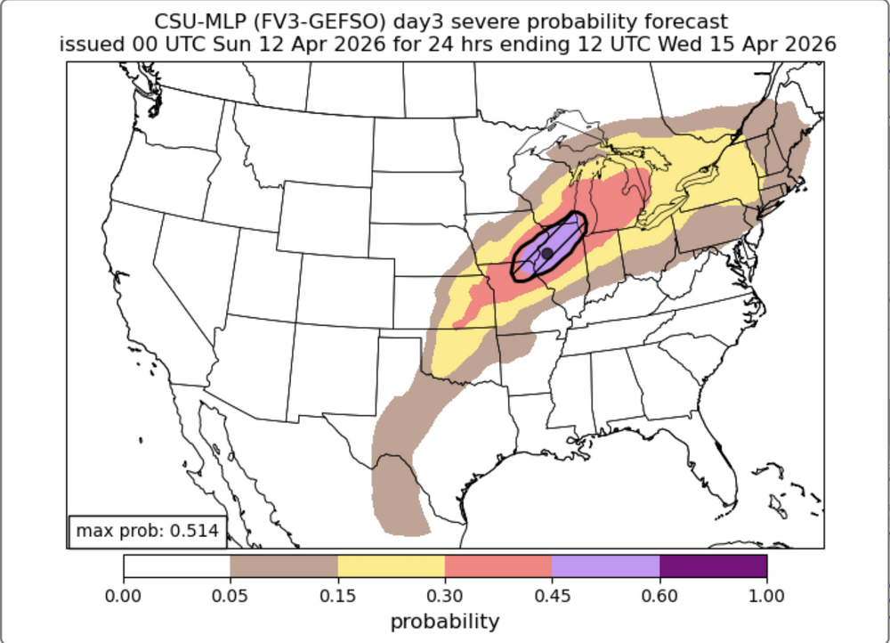
 I’m surprised no one is talking about this. Likely the most intense storm in several years. https://x.com/zeb199818/status/2043312086869287255?s=46&ct=rw-null .
 -
this was probably the last day i worn the winter gear until this fall..
-
yeah, kinda concerned about flooding potential in the area this week, especially as soils are pretty saturated already


.thumb.jpg.ad3a2e31d30aff035044689b311a0540.jpg)
