All Activity
- Past hour
-
1.04'' this morning. Up to 12.34'' for the month.
-

2026-2027 Super El Nino
michsnowfreak replied to Stormchaserchuck1's topic in Weather Forecasting and Discussion
Just a suggestion if you guys make future snow maps closer to winter. It usually helps if you give a rough % of average to go in line with your thinking. I knew what raindance was getting at with the snow map (admittedly just a preliminary joke map rough idea) but it always looks funny when you see something like "snowy" in Atlanta and "not snowy" in Marquette. -
 do you want to fuck her like every other climate change denier
 -

2026 Mid-Atlantic Severe Storm General Discussion
high risk replied to Kmlwx's topic in Mid Atlantic
I'd usually agree with you. But as we now move into CAM range, recognizing that the U.S. CAMs all have some influence of the GFS, the solutions seem to be favoring the GFS more. The idea of a deep sfc low over the St Lawrence Valley isn't dead in the Euro, but even its AI version likes a secondary low in the Mid-Atlantic. Verbatim, some pretty strong forcing rolls through during the morning and midday hours, which screams flash flooding more than severe. That said, 1) a surface low will be nearby, so you always need to watch for a tornado threat, especially if we can heat up before the forcing arrives 2) there is time to change some of the synoptic details -

2026-2027 Super El Nino
40/70 Benchmark replied to Stormchaserchuck1's topic in Weather Forecasting and Discussion
If I had a snowfall map right now, it would look like raindance's. -
2026-2027 Super El Nino
40/70 Benchmark replied to Stormchaserchuck1's topic in Weather Forecasting and Discussion
I could not agree with raindance more....my QBO composite is a bit different, but he just echoed that premise of my write up last night with absolute surgical precision in just a far more condensed manner. Here an excerpt from my work: Key Factors to Potentially Fuel More Active Second Half than Currently Forecast The preliminary Eastern Mass Weather polar composite is littered with seasons that underwent a notable transition from a benign December-January period to a rather frenzied February and/or March, as El Niño peaks and undergoes a subtle change in orientation. It was mentioned that this is a signal that is emergent among some seasonal guidance. It was postulated that these forecasts are overstated and exaggerated, and are likely to be transient in nature. However, it was also asserted that the forecast unprecedented intensity of El Niño should be of sufficient magnitude to at long last shift the western Pacific warm pool, which has been a fixture for a over a decade, further to the east. The question is whether it simply shifts to the dateline and acts as a Modoki, or even further east, which would heighten the odds of a very mild outcome, per the intense/east-based El Niño composites. Another option is for it to not move enough, which may produce an outcome similar to the MC-oriented 2023-2024 season, which is viewed was the least likely outcome. At the very least, the European seasonal guidance is supporting the current forecast for a mid season transition to greater volatility, but it looks to be even more exaggerated given it's assessment of the January polar domain. Perhaps the eruption of Mount Agung was not justification for the outright dismissal of the 1963-1964 QBO analog from the polar composite, however, there is plenty of time to assess that decision as subsequent trends are modeled and future data is digested. -
Enhanced for wi
-
I’m not yet convinced we’ve turned the corner on the long term drought and that giga-Nino is kicking in precip-wise…but the evidence is building. I’ll have to see what august looks like. I’m feeling pretty sure that by mid/late September we’ll have turned the corner for good. At least until our next multi year Nina which starts next fall lol
-
 Our lifetimes at least.
 -
Interesting
-
It’s not on the books but that doesn’t mean it won’t happen.
-
Lol the nam went berserk. 6 to 10" of rain
-
(002).thumb.png.6e3d9d46bca5fe41aab7a74871dd8af8.png)
Central PA Summer 2026 Discussion/Obs Thread
ChescoWx replied to Voyager's topic in Upstate New York/Pennsylvania
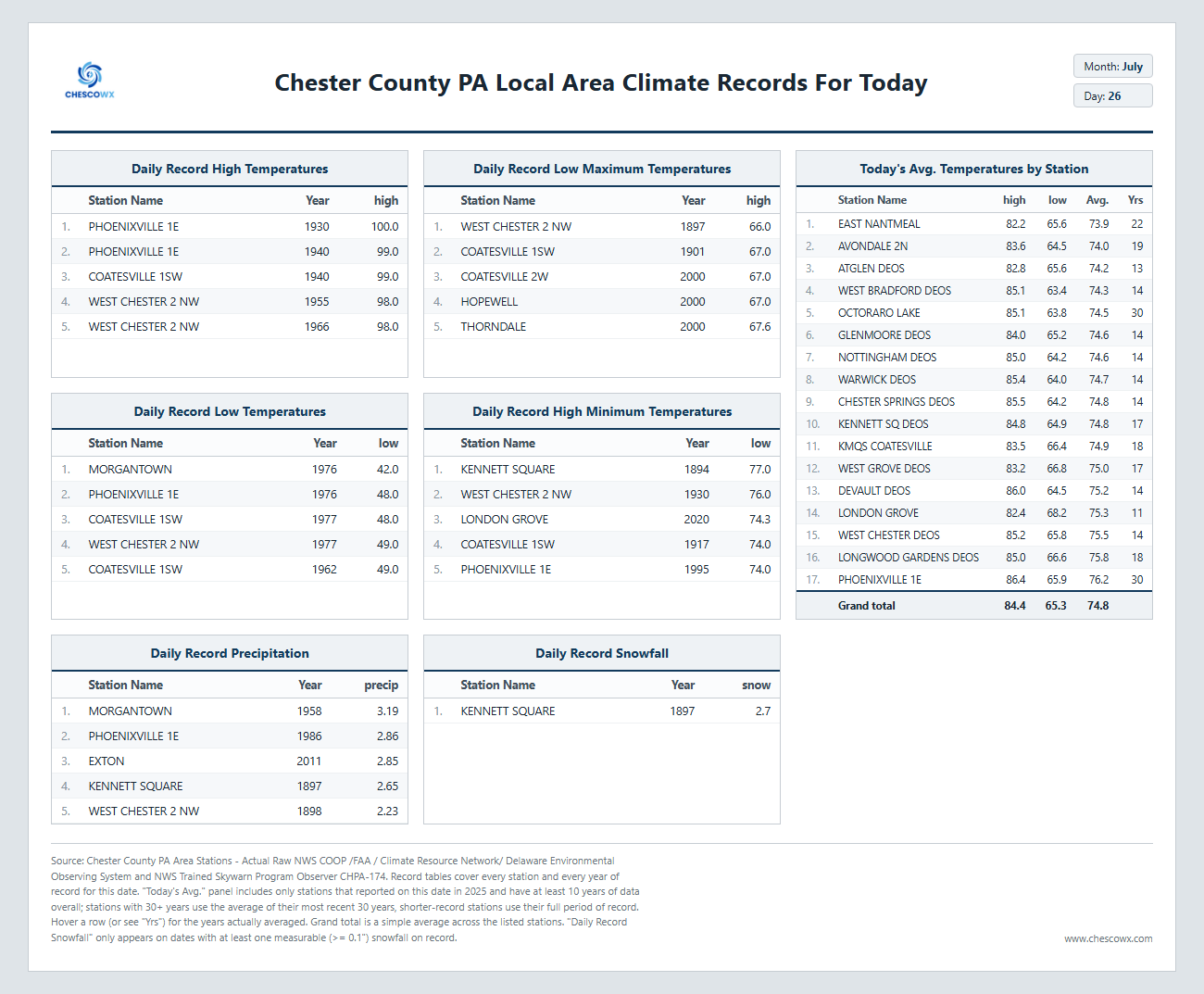
One last great weather day before we turned unsettled and wet for a good part of the upcoming work week. Hopefully, most of us see some rain as many spots, especially across Northern Chester County missed the rains last week. Below normal temperatures look to continue all week but with increasing humidity with the rain. The sun looks to it will return by Friday. Note: below on the climate records there is an errant snow report in the data set that is being corrected.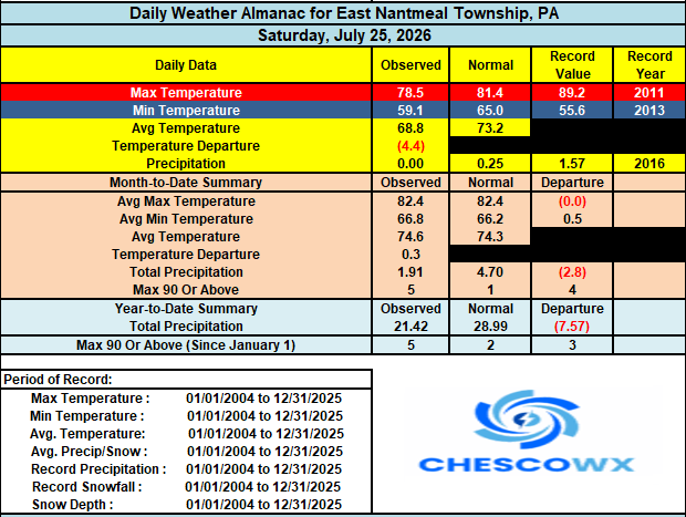
-
E PA/NJ/DE Summer 2026 Obs/Discussion
ChescoWx replied to PhiEaglesfan712's topic in Philadelphia Region
One last great weather day before we turned unsettled and wet for a good part of the upcoming work week. Hopefully, most of us see some rain as many spots, especially across Northern Chester County missed the rains last week. Below normal temperatures look to continue all week but with increasing humidity with the rain. The sun looks to it will return by Friday. Note: below on the climate records there is an errant snow report in the data set that is being corrected.
-
Another .5 this morning. Right at 5 since Wednesday afternoon.
-
1.34 overnight... This week we have had over 4 inches and over 8 on the month
- Today
-

2026-2027 Super El Nino
GaWx replied to Stormchaserchuck1's topic in Weather Forecasting and Discussion
History strongly supports a +PDO by no later than Nov as 94% of the 36 mod+ Ninos since the 1850s had a +PDO in Nov or earlier as only 2 didn’t have a NOAA +PDO by Nov: 1994/5 & 2023/4. -
Will you be doing the Tangier eclipse next year?
-
The shading represents the probability of AN temps, not the intensity of the anomaly.
-

Mid-Long Range Discussion 2026
WinstonSalemArlington replied to BooneWX's topic in Southeastern States
-
 Cleetus snow is a person. Global warming is taking the day off. Go outside and touch grass. Greta won’t say anytning.
 -
 WPC already going slight risk D3/4 with talk of upgrading to moderate in the discussion Will be interesting to see CAMs as we get into range. Potential is there for prolific totals.
 -
Records: Highs: EWR: 99 (2005) NYC: 98 (1940) LGA: 98 (1940) JFK: 94 (1982) Lows: EWR: 57 (1953) NYC: 55 (1920) LGA: 62 (1976) JFK: 58 (1976) Historical: 1819 - Twin cloudbursts of fifteen inches struck almost simultaneously at Catskill, NY, and Westfield, MA. Flash flooding resulted in enormous erosion. (David Ludlum) 1874: Torrential rainfall brought flash flooding to Pittsburg, Pennsylvania. 1875: A windstorm, possibly a tornado, ripped through Erie, PA killing 134 people and causing $500,000 dollars damage. (Ref. Wilson Wx. History) 1890: During the morning hours, an estimated F3 tornado went through the southern part of Lawrence, Massachusetts. The tornado left 500 people homeless as the tornado destroyed 35 homes and damaged 60 others. 1897: Jewel, Maryland received 14.75 inches of rain in a 24 hour period. This record is currently the oldest, state rainfall record in the United States. All other state rainfall records are in the 1900s and 2000s. 1931: A swarm of grasshoppers descends on crops throughout the American heartland, devastating millions of acres. Iowa, Nebraska, and South Dakota, already in the midst of a bad drought, suffered tremendously from this disaster. 1943 - Tishomingo, OK, baked in the heat as the mercury soared to 121 degrees, a state record. (The Weather Channel) 1960 - The temperature at Salt Lake City, UT, hit 107 degrees, an all-time record high for that location. (The Weather Channel) 1974: Cleghorn, La.--A 27-year-old man was killed by lightning while working near a metal tool shed. (Ref. Lightning-The Underrated Killer.pdf) 1977: Canadian high pressure brought record cold temperatures to parts of the Great Lakes region. Record lows included: Madison, WI: 46°, Muskegon, MI: 46°, Green Bay, WI: 47°, Flint, MI: 48, Toledo, OH: 50°, Detroit, MI: 50° and Springfield, IL: 52°. (Ref. Wilson Wx. History) 1979: Tropical Storm Claudette stalled over Alvin, Texas, inundating the town with 45 inches of rain in 42 hours. The total included 43 inches in 24 hours, which is the maximum 24-hour rainfall in American history. 1986: Strong thunderstorms hit north central South Dakota. One of these storms was a very efficient rain producer as it dumped 2.25 inches of rain in 10 minutes near McLaughlin. Strong thunderstorm winds did damage near Mitchell on that same day. The strong winds destroyed a barn, a roof, and windmill in the Mitchell area. (Ref. Wilson Wx. History) 1987 - Thunderstorms developing along a cold front produced hail two inches in diameter in McHenry County, IL, and wind gusts to 70 mph at Auburn, ME. A wind gust of 90 mph was recorded at Blairstown, NJ, before the anemometer broke. The high winds were associated with a small tornado. The record high of 88 degrees at Beckley, WV, was their sixth in a row. (The National Weather Summary) (Storm Data) 1988 - Thunderstorms produced large hail and damaging winds in the Middle Atlantic Coast Region, and in the south central U.S. Eight cities in the northwestern and north central U.S. reported record high temperatures for the date. Salem, OR, hit 103 degrees. (The National Weather Summary) 1989 - Morning thunderstorms produced heavy rain in southeastern Texas, with more than three inches reported at the Widllife Refuge in southwestern Chambers County. Evening thunderstorms produced severe weather in Montana, with wind gusts to 62 mph reported at Helena. Eight cities from Maine to Minnesota reported record high temperatures for the date, including Newark, NJ, with a reading of 99 degrees. (The National Weather Summary) (Storm Data) 1993: Pueblo, Colorado: Record high for date, 101°F and record low for date 52°F, set on same day! (Ref. WxDoctor) The Great Mississippi River Flood of 1993: Rising water stopped all rail traffic through Kansas City, MO. A tornado moved along a 4 mile track across parts of northwest Scottsbluff, NE. The tornado destroyed a furniture store and about 8 homes, with about $3 million dollars in damage. (Ref. Wilson Wx. History) 2000: A line of thunderstorms developed in Iowa and pushed southward into northwest Missouri. The early storms produced large hail in the northwest corner of Missouri. Wind gusts in excess of 70 mph and widespread wind damage occurred from the St. Joseph area southward to the Kansas City metro and other locations in west central Missouri. The highway department reported downed trees up to 4 feet in diameter. A building under construction in an industrial park sustained over $1 million dollars in damage. (Ref. Wilson Wx. History) 2001: Two Boy Scouts were injured by lightning while at a campsite during the National Scout Jamboree at Fort A.P. Hill in Caroline County, VA. (Ref. Lightning - Virginia Weather History) Up to 8 inches of rain fell in about 3 to 4 hours across Copiah County, Mississippi. Various portions of Rankin County had significant flooding. In Pearl, several roads had to be closed. Water also covered several roads in Brandon where up to six inches of rain fell in a few hours. (Ref. Wilson Wx. History) 2006: Death Valley National Park, California: The low temperature for the day bottoms out at a scorching 104°F. The day's high was only 116°F. Fresno, CA recorded their 5th straight night with a minimum temperature of 80° or better. This is their longest such streak on record. (Ref. WxDoctor) 2009: Rio Grande Valley, Texas: Since June 12th, San Antonio has registered 31 days with temperatures in the 100s °F. Across the Rio Grande Valley, extreme heat in McAllen this month has been staggering with 20 days of record-setting high temperatures. This day made it the 11th day in a row that new record highs were set. (Ref. WxDoctor)
-
76 / 53mid 80s in spots today and another day of this nice stretch before we get into a cutoff trough into the northeast Tue - Fri with upwards of 1 - 3 inches + pending on where the heaviest storms / rain setup. Clears out for a nice stretch in time for next weekend and to open the month. Warmer overall 8/3 - beyond.
-
 I think you were just a bit too far south. Maybe the cutoff will have some.