All Activity
- Past hour
-
I was thinking the same thing. I remember as a kid strobe light thunderstorms in the middle of the night. You'd wake up to pouring rain and continues flashing and loud thunder. I honestly can't remember the last time that happened.
-
62 this morning. Refreshing.
-
Maybe it is just an 'older man' reminiscing about younger days, but I swear we used to get the 'leftovers' from big midwestern (IL/IN/MO/KY/OH) storms to swing thru here from the W or NW late overnight into the early morning hours.
-

2026-2027 Super El Nino
LakePaste25 replied to Stormchaserchuck1's topic in Weather Forecasting and Discussion
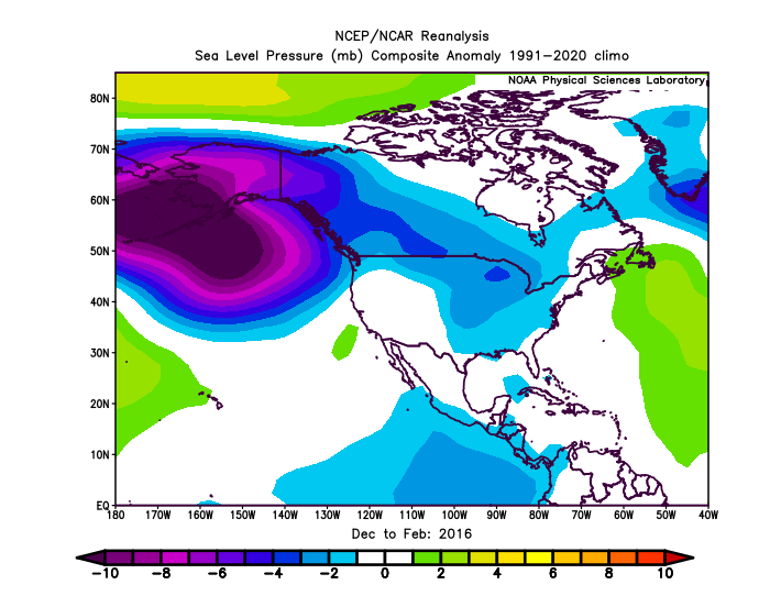
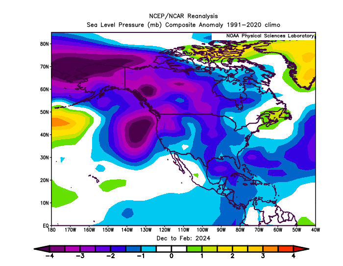
The stronger ridges and weaker troughs are likely playing a huge role. If you look at SLP, it’s less muted. However, still some subtle differences between the events.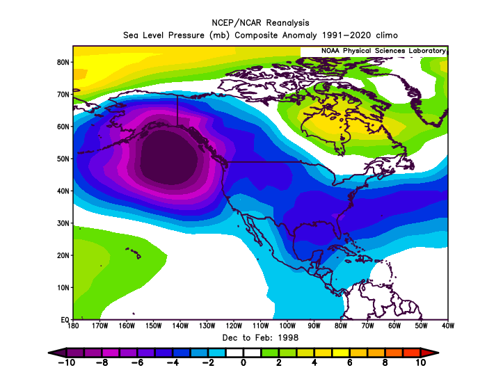
-

Chester County PA - Analytical Battle of Actual vs. Altered Climate Data
chubbs replied to ChescoWx's topic in Climate Change
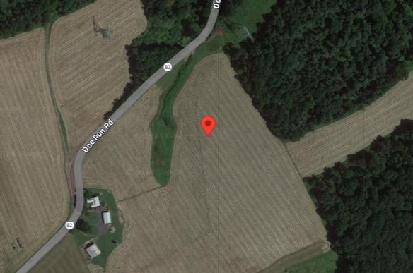
Per your table the Chesco COOPs and the Philadelphia Airport both averaged 54.1 between 1942-44. After 1945 the large cooling moves started in the Chesco COOPs. By the early 1970s the COOPs were almost as cool as ABE. Clearly shown in the chart I posted above. The raw COOP data is unusable for climate purposes in this period. Not sure why this is so hard for you to understand. The Coatesville stations below, 1930-1945 and 1949+ are very different. These two sites are not equal proxies for the County average temperature. One is much cooler than the other and the local raw data shows it. That's why NCEI gets the right answer for Chesco and you don't.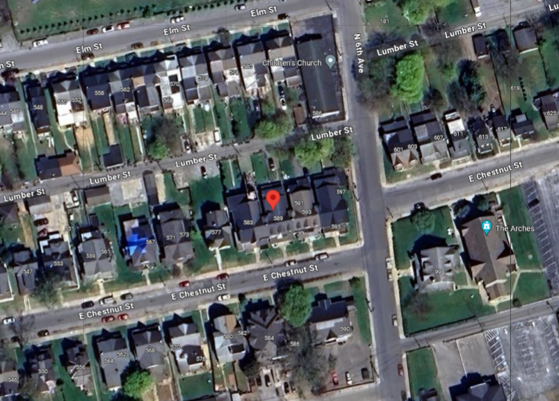
-

Central PA Summer 2026 Discussion/Obs Thread
pawatch replied to Voyager's topic in Upstate New York/Pennsylvania
64 degrees this morning! -
-

Central PA Summer 2026 Discussion/Obs Thread
mahantango#1 replied to Voyager's topic in Upstate New York/Pennsylvania
URGENT - WEATHER MESSAGE National Weather Service State College PA 204 AM EDT Mon Jul 13 2026 PAZ004>006-010>012-018-019-027-028-037-041-042-045-046-049>053- 056>059-140700- /O.NEW.KCTP.HT.Y.0004.260714T1500Z-260715T0000Z/ Warren-McKean-Potter-Elk-Cameron-Northern Clinton-Northern Centre- Southern Centre-Mifflin-Juniata-Tioga-Northern Lycoming-Sullivan- Southern Clinton-Southern Lycoming-Union-Snyder-Montour- Northumberland-Columbia-Perry-Dauphin-Schuylkill-Lebanon- Including the cities of St. Marys, Laporte, Emporium, Wellsboro, Pottsville, Warren, Berwick, Hershey, Shamokin, Ridgway, Lewistown, Mansfield, Trout Run, Danville, Mifflintown, Sunbury, Lock Haven, Williamsport, Harrisburg, Lebanon, Renovo, Selinsgrove, Bloomsburg, State College, Philipsburg, Lewisburg, Coudersport, Newport, and Bradford 204 AM EDT Mon Jul 13 2026 ...HEAT ADVISORY IN EFFECT FROM 11 AM TO 8 PM EDT TUESDAY... * WHAT...Heat index values of 96 to 103 degrees expected. * WHERE...A portion of central Pennsylvania. * WHEN...From 11 AM to 8 PM EDT Tuesday. * IMPACTS...Hot temperatures and high humidity may cause heat illnesses. * ADDITIONAL DETAILS...The Heat Advisory may need to be extended into Wednesday for a portion of central Pennsylvania as another hot day is looking increasingly likely. PRECAUTIONARY/PREPAREDNESS ACTIONS... Drink plenty of fluids, stay out of the sun, and stay in an air-conditioned room. Check up on relatives and neighbors, and provide pets with adequate water and shelter from the sun. Know the signs and symptoms of heat exhaustion and heat stroke. Review heat safety and preparedness information at weather.gov/safety/heat. If you do not have air conditioning in your home or lack shelter, you can call 211 or visit pa211.org for assistance locating appropriate shelter from the heat. && $$ -
Over 4” at the farm in Louisburg since yesterday and still pouring
-
@WxWatcher007 home brew next weekend???
-
0.5” Friday night. 1.6” last night. Total for July so far: 7.3 “ The Falls Lake watershed has been the place to be the last two months.
-

2026-2027 Super El Nino
bluewave replied to Stormchaserchuck1's topic in Weather Forecasting and Discussion
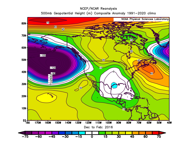
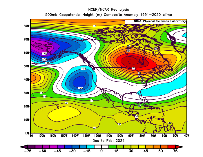
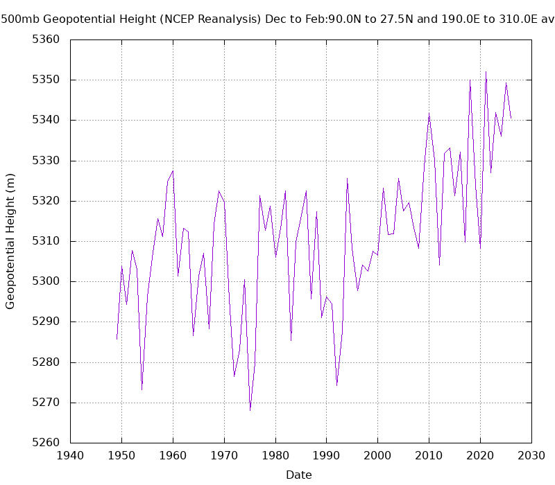
I realize that and was talking more generally about the DJF means. 1997-1998 had the strongest connection between the Aleutian low and the low across the Southern Tier of the CONUS. There is always going to be variability from month to month and season to season between different super El Ninos. By 2015-2016 the Aleutian low was weaker along with the low in the Southeast even with the strong +PDO. 2023-2024 also had a weaker Aleutian low that split into two pieces. So the low across the Southeast was weaker than 1997-1998 also in the means. It’s also possible that the warming climate leading stronger and more extensive ridges and weaker troughs is playing a role also. The chart below shows the rising 500mb heights over North America and the adjacent oceans during DJF.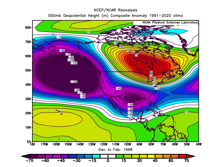
-
lol
- Today
-
locked in

-
Gorgeous clear morning! 68 degrees out.
-
 https://vgrsansordonnance.top/# Viagra 100 mg sans ordonnance
 -
Non-stop rain tonight.
-
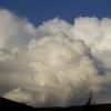
2026-2027 Super El Nino
BlizzardWx replied to Stormchaserchuck1's topic in Weather Forecasting and Discussion
I've been thinking about this too. Makes you wonder if with CC what is typical of el nino could be changing or if we've just been oversubscribing a small sample size. Either one says we aren't necessarily going to get a big GOA low. It also says maybe the El nino - PDO connection is less settled than we think. -
Rain just keeps regenerating over my area. It just pluses up, dies down and pulses up again. It doesn't really move at all. It's been raining for hours now from it.
-

2026-2027 Super El Nino
GaWx replied to Stormchaserchuck1's topic in Weather Forecasting and Discussion
I’m educatedly guessing that the weekly relative Nino 3.4 will rise from last Monday’s +1.2 to +1.4 in today’s release. I’m guessing 1+2 will be in the +2.7 to +2.8 range. These weeklies are OISST based. https://www.cpc.ncep.noaa.gov/data/indices/rel_wksst9120.txt -

2026-2027 Super El Nino
Stormchaserchuck1 replied to Stormchaserchuck1's topic in Weather Forecasting and Discussion
Western subsurface is not really cold like you see in a lot of developing Super Nino's by now. -

Central PA Summer 2026 Discussion/Obs Thread
Jns2183 replied to Voyager's topic in Upstate New York/Pennsylvania
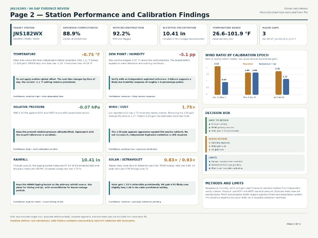
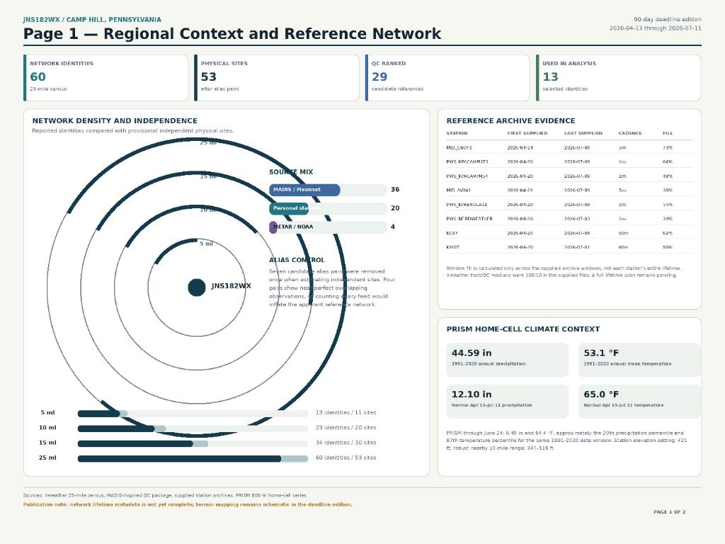
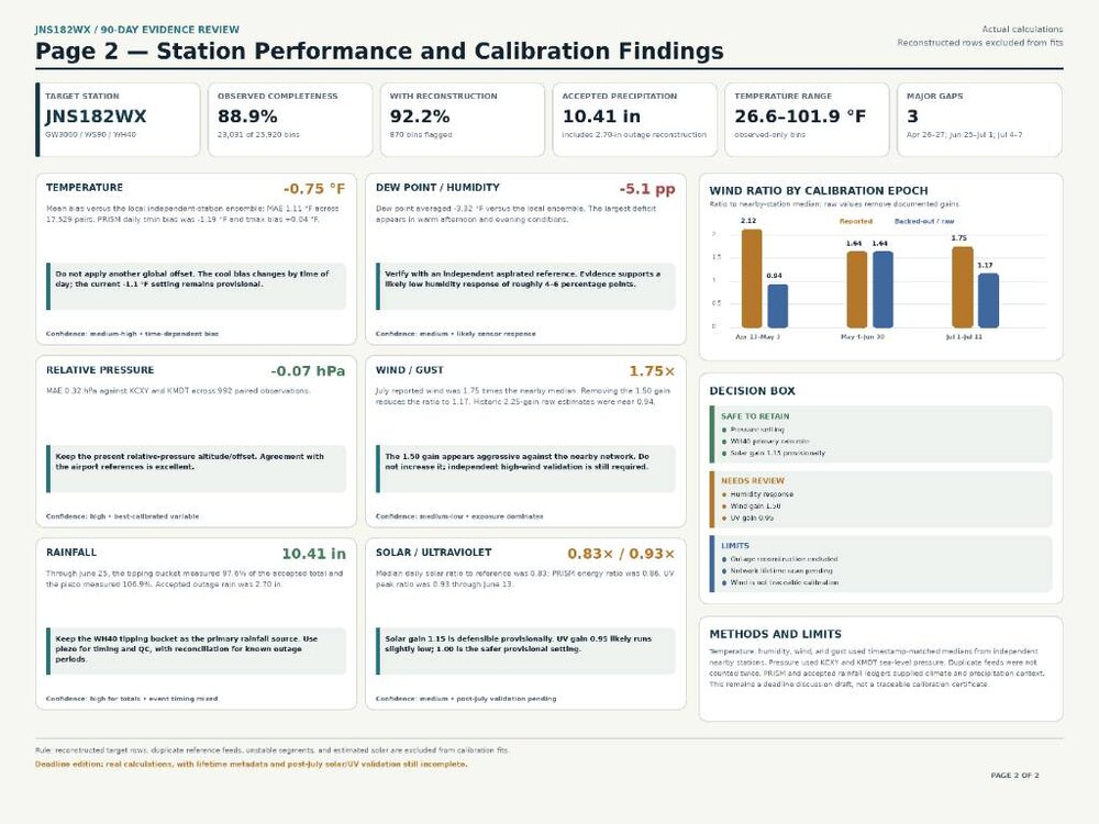
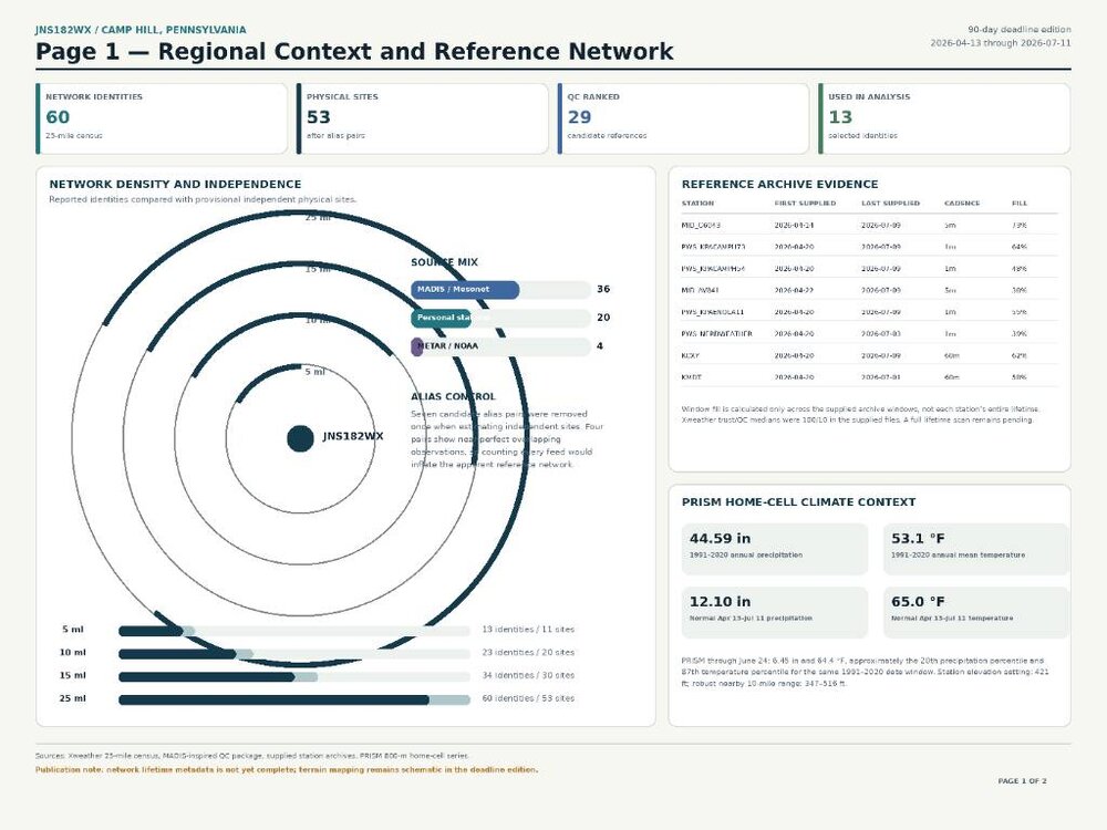
I’m offering to perform this same kind of MADIS-inspired quality-control and calibration analysis for other personal weather-station owners. The analysis can examine data completeness, outages, nearby independent reference stations, duplicate feeds, temperature and humidity bias, pressure accuracy, wind multipliers, rainfall performance, and solar or ultraviolet readings where available. I would need at least 90 days of timestamped station. and for now I would analyze a maximum of one year. At minimum, I would also need the station location and elevation, hardware and sensor models, siting details, and any correction settings or known equipment changes. Anyone interested can direct-message me with their station information and available data. TLDR...... I take your station’s historical data and compare it against nearby independent weather stations, airport observations, MADIS/Xweather records, and local climate data. I clean the records, remove duplicate or unreliable stations, identify outages and bad readings, then measure how your temperature, humidity, pressure, wind, rain, solar, and UV differ from the best available references. From that, I produce a plain-language report showing what is accurate, what is biased, and which calibration settings should be kept, changed, or verified. I've slowly build it out.I’d describe the system as about 80% automated at this point. I collect the station and nearby reference data, then the system automatically cleans it, removes duplicate or unreliable feeds, identifies gaps, calculates biases, and generates most of the comparisons. I still manually review unusual results, confirm the best reference stations, and decide what calibration recommendations are scientifically defensible, and not just giving your wind data witch craft spells so it matches KMDT better and doesn't require rooftop thuggery. Sent from my SM-S731U using Tapatalk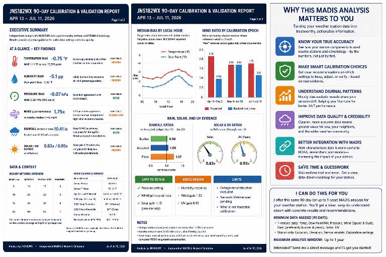
-
Just getting crumbs compared to Wake and Harnett, but back building of moderate rain has yielded 0.40". 1.93" for the month.
-
That’s the heaviest rate I’ve ever observed. Several flashes of lightning, board clear, 12 minutes later 1” and ended up 2.75 for the hour
-

2026-2027 Super El Nino
PhiEaglesfan712 replied to Stormchaserchuck1's topic in Weather Forecasting and Discussion
It depends on how early the el nino dissipates. If it peaks earlier than normal (in the fall, rather than winter), then we might get a robust la nina that challenges 1973-74 and 1988-89 (both of these, of course, followed robust el ninos).