All Activity
- Past hour
-
I had to Google MLM and got this… and I’m thinking, that’s probably not what he’s talking about . “In modern slang, MLM almost universally stands for "Men Loving Men."”
-
I may have already subscribed and ordered a shirt. Haven't messed around with the app much yet but liking it so far.
-
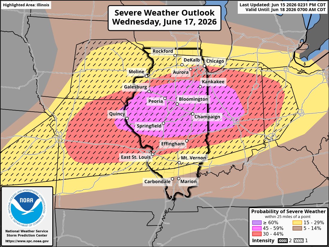
New NAM brings the action up to the 88. area.
-
Cooler weather has now returned to the region. Temperatures will likely top out in the middle to upper 70s tomorrow through Wednesday. It will then become somewhat warmer to conclude the week. No heat appears likely through at least June 25th. The ENSO Region 1+2 anomaly was +2.6°C and the Region 3.4 anomaly was +1.3°C for the week centered around June 3. For the past six weeks, the ENSO Region 1+2 anomaly has averaged +1.95°C and the ENSO Region 3.4 anomaly has averaged +0.98°C. The ongoing El Niño will continue to strengthen through the summer. The SOI was -12.93 today. The preliminary Arctic Oscillation (AO) was -0.321 today. Based on sensitivity analysis applied to the latest guidance, there is an implied near 78% probability that New York City will have a warmer than normal June (1991-2020 normal). June will likely finish with a mean temperature near 74.1 (2.1° above normal). Supplemental Information: The projected mean would be 2.7° above the 1981-2010 normal monthly value.
-
I had a garden hose go wild on me and got me good. Actually felt cold with the wet-bulb + wind! Good stuff.
-

2026 Mid-Atlantic Severe Storm General Discussion
wxmeddler replied to Kmlwx's topic in Mid Atlantic
80 mph straight line winds determined by LWX survey last night near Libertytown (Frederick Co.) https://partnerservices.nws.noaa.gov/products/cache/166-2026/PNSLWX/187943434c0858f4f13424bc30b0894e -
0.00" yesterday. Major fail given the forecast. About a half inch for the month so far, on top of half/less than half of normal rainfall the last 3 months. Drought status may be upped here this week. Was already pretty close to Extreme. I'll keep running the sprinklers for the plants. Grass is toast, clover hanging in there.
-
 We've been talking about a window for tropical development for weeks, and now we have our first invest of the season. Regardless of development, heavy rain will continue across much of the south. Separating out a thread so we can continue the discussion here. Tropical Weather Outlook NWS National Hurricane Center Miami FL 200 PM EDT Mon Jun 15 2026 For the North Atlantic...Caribbean Sea and the Gulf of America: Northwestern Gulf of America: A trough of low pressure located over northeastern Mexico is producing a large area of disorganized showers and thunderstorms. Development is not expected during the next day or so while the trough remains inland. However, the system could re-emerge over the northwestern Gulf of America late Tuesday or Wednesday, and environmental conditions there are marginally conducive for the formation of a short-lived tropical storm on Wednesday into Thursday. Regardless of tropical cyclone formation, interests across southern and eastern Texas and portions of Louisiana and Mississippi should prepare for periods of intense rainfall over the next several days which could produce widespread, life-threatening flash, urban, and river flooding. Gusty winds and coastal flooding are also possible along portions of the northwestern Gulf Coast, and Tropical Storm Watches or Warnings could be required on Tuesday. Additional information on this system can be found in products issued by your local National Weather Service Forecast Office or NHC Key Messages. * Formation chance through 48 hours...medium...40 percent. * Formation chance through 7 days...medium...50 percent. $$ Forecaster Blake
 -

Central PA Summer 2026 Discussion/Obs Thread
canderson replied to Voyager's topic in Upstate New York/Pennsylvania
I only had .24”. It skirted NW with the heavy precip -
-
There were some pretty nice lenticulars over Yancey and Mitchell this morning...and what a perfect weather day it's been! 61 today. Sent from my Pixel 10 Pro using Tapatalk
-

Central PA Summer 2026 Discussion/Obs Thread
mappy replied to Voyager's topic in Upstate New York/Pennsylvania
Thanks! STP noted this morning they’d be looking into damage reports in York/Lancaster where that cell traveled. Friend is ok! - Today
-
Influencer/mlm is more toxic
-

Central PA Summer 2026 Discussion/Obs Thread
Mount Joy Snowman replied to Voyager's topic in Upstate New York/Pennsylvania
Thanks JNS. Thought you may be the one to know haha. Well, that stinks. That site had been one of my main daily go-to visits for many years. A great one-stop shop. Ugh. -
It will be nice to get rid of celebs once we’re onto AI movies and music.
-

Central PA Summer 2026 Discussion/Obs Thread
Jns2183 replied to Voyager's topic in Upstate New York/Pennsylvania
Is there some aspect of it that you were looking for mostly I could probably guide you even further Sent from my SM-S731U using Tapatalk -
.thumb.jpg.6a4895b2a43f87359e4e7d04a6fa0d14.jpg)
Central PA Summer 2026 Discussion/Obs Thread
Yardstickgozinya replied to Voyager's topic in Upstate New York/Pennsylvania
Apparently there was a sasquatch. sighting in the neighborhood that I'm working in. They said that it's wearing an orange shirt and a black hat.I looked everywhere.I think these people are full of s***.
-
Especially impressive for daytime highs with several locations having a record hot first 2 weeks of June, including Islip and Newark. Looks like a little break coming in, but I do not think we are done with heat. Personally, I think these summer cancel calls are way too early.
-
Central PA Summer 2026 Discussion/Obs Thread
Jns2183 replied to Voyager's topic in Upstate New York/Pennsylvania
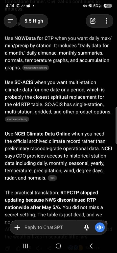
It's because they took it out to the wood shed and discontinued the product https://www.weather.gov/media/notification/pdf_2026/scn26-34_AR_ER_WR_RTP_Discontinuation.pdf The screenshot there has your best chances to find a replacement Sent from my SM-S731U using Tapatalk
-
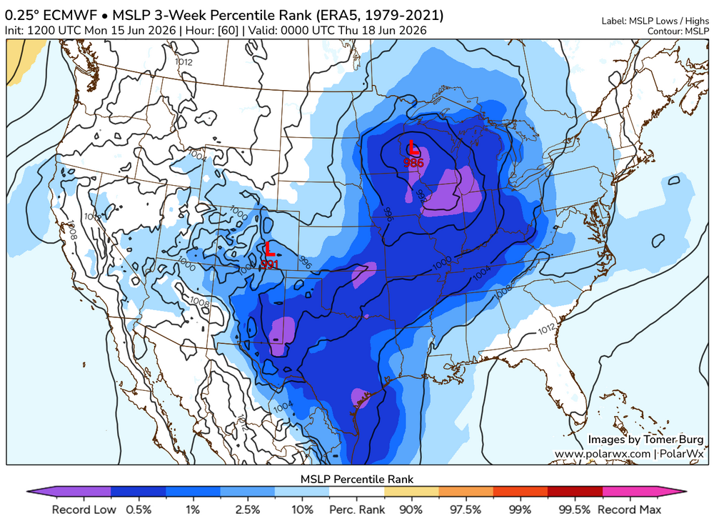
Generally when you blend a record strength 500 mb shortwave with a record strength surface low, you're going to expect some pretty anomalous outcomes assuming moisture is available, which it looks to be.
.thumb.png.63de12ab5eb22478206e6197893d2b8c.png)
-
Beautiful day with temps hovering around 80, and dews around 50.
-
I think the drought might be completely ended in a lot of Georgia by next week if this tropical low moves through as predicted
-
Woodstock, GA, (25 miles N of ATL) had 3 widely spaced thunderstorms yesterday! It looks like my home area in SAV had several rounds of significant rainfall the last 72 hours with the heaviest being ~1.1” for the 24 hours ending at 7AM today using Cocorahs as a guideline. For the last 72 hours, I roughly estimate 1.4” fell at my location, which is also near my MTD.
-
I’ll consider this a win for Bastardi if it actually becomes a TC. He predicted back in April a Gulf TC due to MJO phase 8 being bullish for Gulf TCs in June. This could provide major drought relief for a good portion of the SE! This is now Invest 90L: https://ftp.nhc.noaa.gov/atcf/btk/bal902026.dat
-
Also a large 45%


.thumb.gif.f92b16c631a1d15d405ed77b33f0710d.gif)


.png.981588a393ec053f28cdcd9c1833d79b.png)