All Activity
- Past hour
-
Back edge rains here presently. Decent rates.
-
0.40" here for the day. Better than nothing, but well under some of the models.
-

E PA/NJ/DE Summer 2026 Obs/Discussion
Mikeymac5306 replied to PhiEaglesfan712's topic in Philadelphia Region
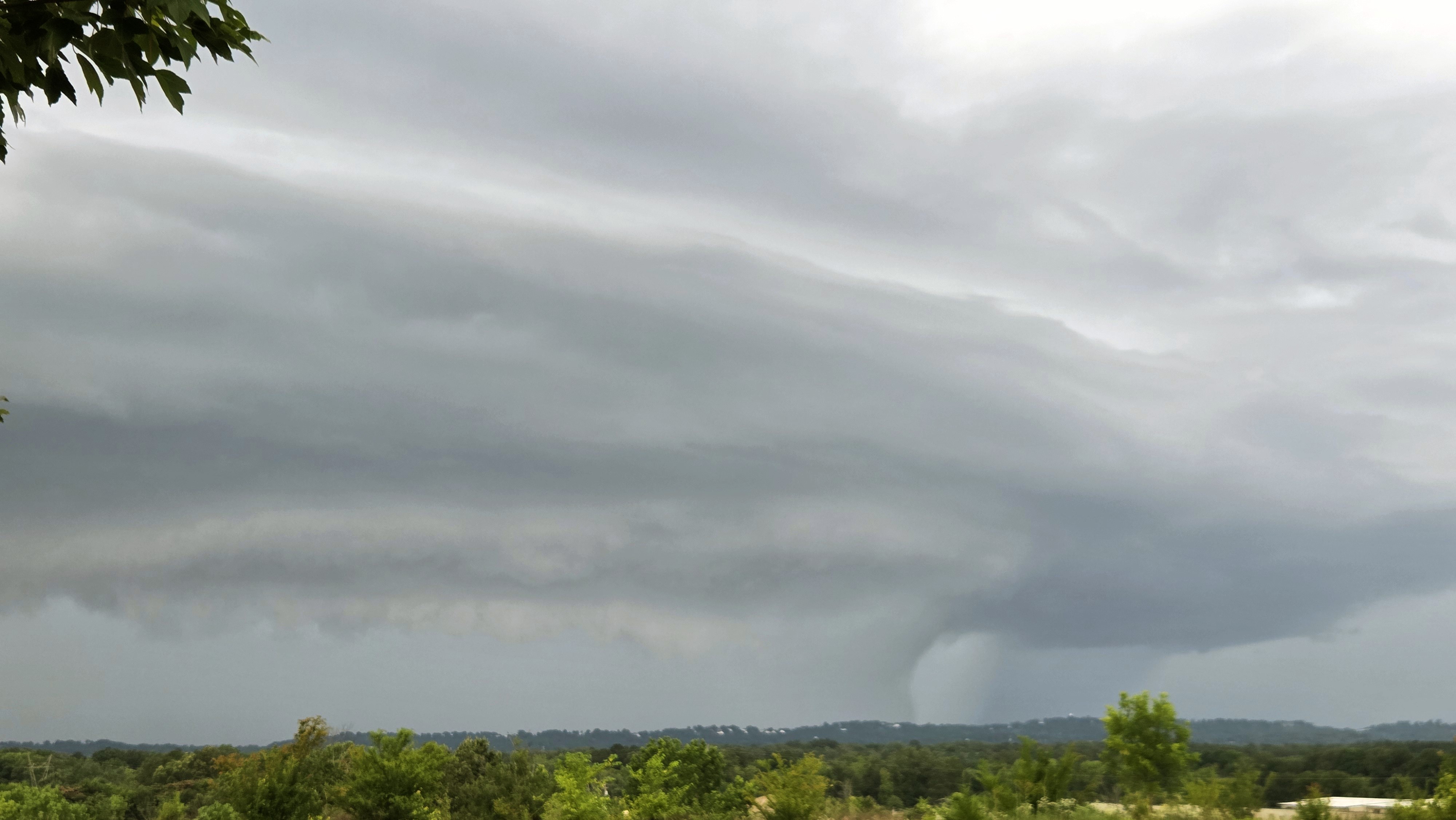
Hey neighbor! This storm looked impressive as anything at 4:30 as I was going up Pottstown Pike. Legit looked like a tornado. Missed our area completely. -

Central PA Summer 2026 Discussion/Obs Thread
canderson replied to Voyager's topic in Upstate New York/Pennsylvania
This was a bust as clear as day. I never saw what SOC saw anywhere W of Chester county. Overhead mixing means nothing with no cape and no trigger. Ans chances of ashore overnight is slim at best. Water restrictions coming soon to some municipalities. -

E PA/NJ/DE Summer 2026 Obs/Discussion
BBasile replied to PhiEaglesfan712's topic in Philadelphia Region
Great dynamics. The wind completely flipped. -
Finally some heavy rain
-
.89” here
-
maybe some trainingish rains building in CNJ though they aren’t exactly on a line
-

Central PA Summer 2026 Discussion/Obs Thread
Voyager replied to Voyager's topic in Upstate New York/Pennsylvania
Yikes....that's bad. -

E PA/NJ/DE Summer 2026 Obs/Discussion
Hurricane Agnes replied to PhiEaglesfan712's topic in Philadelphia Region
And here comes a huge round 4 that gave me upwards of 2.5"/hr rates and now have 2.56".
-
Radar says some 2-2.5” amounts just to my south.
-
The old Wake County Fizzle kicked in.
-
0.70” for Syosset & 0.65” for Muttontown so far.
-

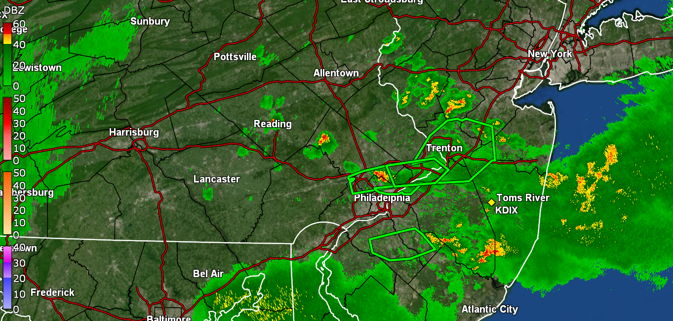
2026 Mid-Atlantic Severe Storm General Discussion
southmdwatcher replied to Kmlwx's topic in Mid Atlantic
Well can't send in a Cocorah's report tomorrow. Regulation flag pole in the backyard came down and took out the rain gauge. After last night's full tornado outbreak in Indiana and Illinois that went underforecasted, I kinda expected some events here to overperform. -
.22 here in Sheepshead Bay
-
Central PA Summer 2026 Discussion/Obs Thread
canderson replied to Voyager's topic in Upstate New York/Pennsylvania
It appears they finally dropped the t-storm watch for the south central counties. -
Soon, not even the cactii will be alive.
-
Central PA Summer 2026 Discussion/Obs Thread
canderson replied to Voyager's topic in Upstate New York/Pennsylvania
.05” today for me -
E PA/NJ/DE Summer 2026 Obs/Discussion
Hurricane Agnes replied to PhiEaglesfan712's topic in Philadelphia Region
Just got a light 3rd round. Round 2 gave me another 0.1" to get over the 2" mark and this round has me up to 2.06" so far, although a small cell looks to be coming this way from the southwest. Currently 71 & 70 dp. -
As predicted 0.71" here. A mild ding dent in the extreme drought. A little over an inch here for the month. Need tomorrow to deliver. Ridgely Mesonet recorded 1.24" 3 miles SW of here
-
Up to 1". One of the showers that moved through was torrential for a few minutes.
-
You actually did better than me this time! I only got 0.02”
-
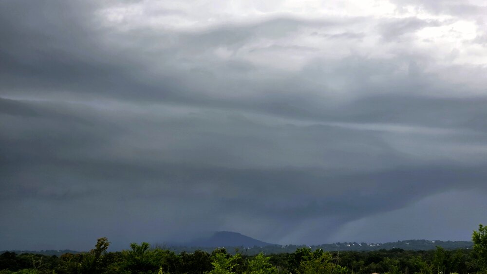
Here is what I saw about 6:30 Eastern from the North Georgia Costco. Lookout Mountain became envoloped. I infer a rain curtain punching out front, but could not discern any rotation. The 80 mph tag was probably justified. I'm shocked Chattanooga doesn't have more damage. As for the Georgia side, I saw a mini-cut (not pictured) but it wasn't enough to spin up a tornado. Warning was justified though; it was trying to rotate.

-

Wet late Monday 6/22 or another Fizzle?
BlizzardNole replied to Weather Will's topic in Mid Atlantic
0.65 at the mesonet a couple miles from me which is great given how parched we are down here. I hope we can luck into some more tomorrow morning -
A few bangers tonight? Or more likely rumbles


.thumb.gif.f92b16c631a1d15d405ed77b33f0710d.gif)