All Activity
- Past hour
-
Watching these storms evaporate into thin 95 / 75 air on approach is simply amazing. Lots of wind though, of course.
-

Central PA Summer 2026 Discussion/Obs Thread
canderson replied to Voyager's topic in Upstate New York/Pennsylvania
96 at the house. Car reads 98 here in camp hill. Had a 2 hour outdoor event at 3. I’m wiped out. It is nasty out. -

2026 Mid-Atlantic Severe Storm General Discussion
batmanbrad replied to Kmlwx's topic in Mid Atlantic
I can see some gust front/outflow boundaries pushing out ahead of that line -
The cell just north of Waldo IL might be next to go if it can stave off any crap-vection.
-
Another discussion, likely a watch is coming for some: https://www.spc.noaa.gov/products/md/md1096.html
-
95 in Kearny, nj still baking!
-
Yaphank got blasted. 2 for 2 with the thunderstorms this year. My highly sheltered PWS saw gusts of 35+ mph, the highest since Isaias. Probably 65-70 mph gusts in reality.
-
Central PA Summer 2026 Discussion/Obs Thread
canderson replied to Voyager's topic in Upstate New York/Pennsylvania
Sorry just got back here. I meant chances - it’ll storm but I don’t see guest severe with hail. Tomorrow is a better chance. -
I wonder if the cell merger well help steer it right at Kankakee, yet again. The track is so similar to the one in March. It’s isolated enough to produce multiple times.
-
https://x.com/Kentucky_WX/status/2065192083921543679?s=20
-

2026-2027 Super El Nino
mitchnick replied to Stormchaserchuck1's topic in Weather Forecasting and Discussion
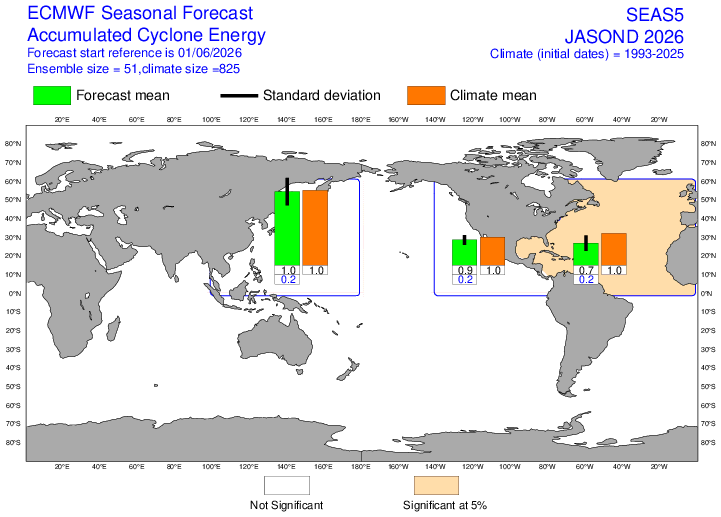
This month's Euro seasonal doesn't look that impressed for hurricanes/tropical systems beyond climo, with only the eastern Pacific showing a slightly higher frequency while all areas, except western Pacific, within the forecast down in the intensity (ACE) department.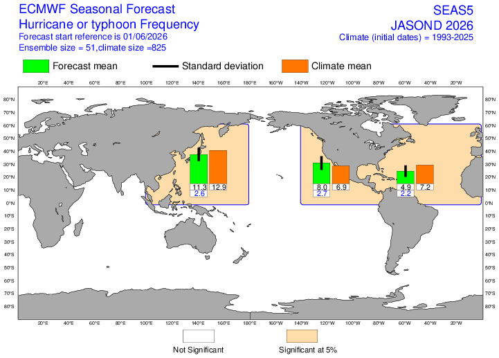
-
Anything coming out from the one that just passed over Toluca?
-
Looks like a couple more spinups possible on that line
-
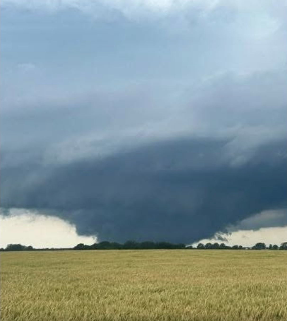
insane pics coming out of that cell... will be interesting to see how it reacts to these mergers
-
102 at 1:42pm. For those of you in Raleigh and east, enjoy the rain.
-
Coming for ALEK job
-
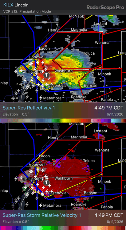
https://www.spc.noaa.gov/products/md/md1097.html Mesoscale Discussion 1097 NWS Storm Prediction Center Norman OK 0513 PM CDT Thu Jun 11 2026 Areas affected...portions of central into northeast Illinois Concerning...Tornado Watch 313... Valid 112213Z - 112315Z The severe weather threat for Tornado Watch 313 continues. SUMMARY...A strong tornado is likely ongoing across Woodford County, Illinois. The strong tornado threat from this storm is expected to continue for several more hours as it moves northeast. DISCUSSION...A debris ball has developed within a low-reflectivity hook west of Washburn, Illinois at 2205Z. This supercell is in a very favorable environment near the modifying outflow boundary across north-central Illinois. The KILX 21Z RAOB showed a very favorable environment with 0-500m SRH of 151 m2/s2. Recent VWP trends from ILX suggest this las likely increased within the past hour also. Given the continued northward movement of the outflow boundary and the discrete nature of this storm, expect an EF3+ tornado threat to continue for several more hours this evening as it moves east/northeast. ..Bentley/Smith.. 06/11/2026 ...Please see www.spc.noaa.gov for graphic product... ATTN...WFO...LOT...ILX...DVN... LAT...LON 40968956 41468879 41548810 41438778 41228773 40968813 40858889 40828939 40968956 MOST PROBABLE PEAK TORNADO INTENSITY...140-170 MPH MOST PROBABLE PEAK WIND GUST...65-80 MPH MOST PROBABLE PEAK HAIL SIZE...1.50-2.50 IN
-
GWDLT
-
Idk anything about the town of Toluca but it doesn't look good for them.
-
RDU officially recorded 101.
-
That’s cool. You, @MazooWeather and I should all get together for a chase.. Or lunch. Something. Would be a good time. Always appreciate both of your .02. We don’t have many on the west side of the mitten any more. @WestMichigan too. @sbnwx85is close enough to count too lol. Also… 21z HRRR completely tapped out. Hopefully we get upscale growth and enough LLJ to vent something over here later.
-
Which presumably means SPC expects that line to keep going. Lets goooooo
- 502 replies
-
- 1
-

-
- severe
- thunderstorms
- (and 7 more)
-
It’s like 200kt gtg
-
detached tornado debris signature and vortex signature west of Washburn IL


.thumb.jpg.ad3a2e31d30aff035044689b311a0540.jpg)