All Activity
- Past hour
-

Central PA Summer 2026 Discussion/Obs Thread
Jns2183 replied to Voyager's topic in Upstate New York/Pennsylvania
Is there some aspect of it that you were looking for mostly I could probably guide you even further Sent from my SM-S731U using Tapatalk -
.thumb.jpg.6a4895b2a43f87359e4e7d04a6fa0d14.jpg)
Central PA Summer 2026 Discussion/Obs Thread
Yardstickgozinya replied to Voyager's topic in Upstate New York/Pennsylvania
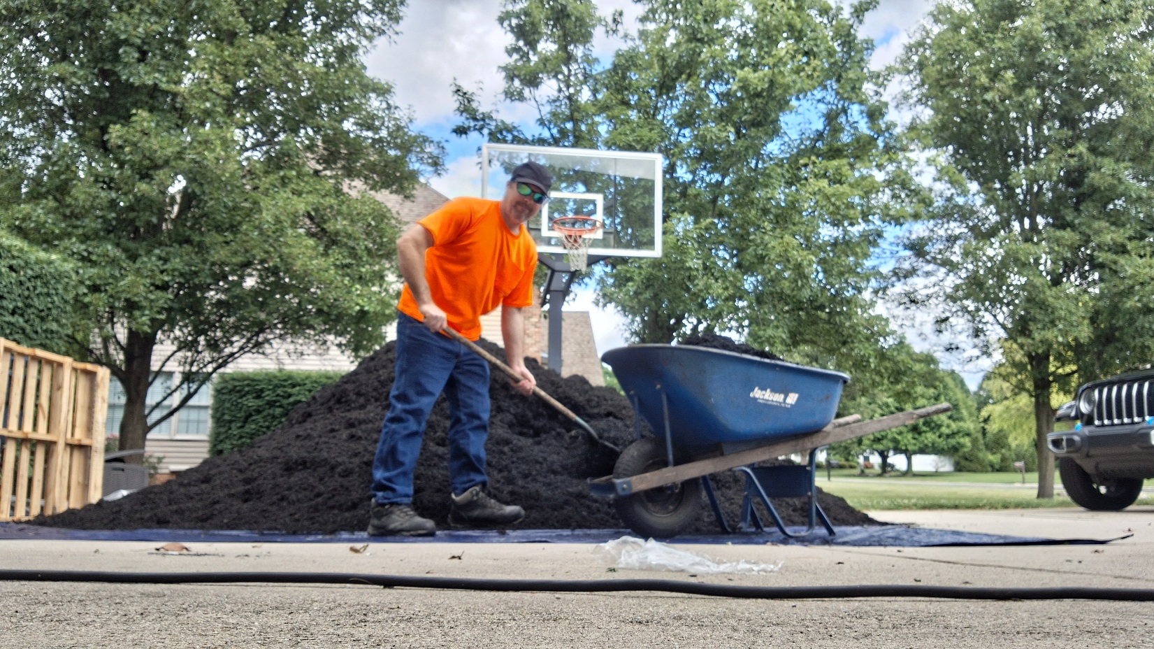
Apparently there was a sasquatch. sighting in the neighborhood that I'm working in. They said that it's wearing an orange shirt and a black hat.I looked everywhere.I think these people are full of s***.
-
Especially impressive for daytime highs with several locations having a record hot first 2 weeks of June, including Islip and Newark. Looks like a little break coming in, but I do not think we are done with heat. Personally, I think these summer cancel calls are way too early.
-
Central PA Summer 2026 Discussion/Obs Thread
Jns2183 replied to Voyager's topic in Upstate New York/Pennsylvania
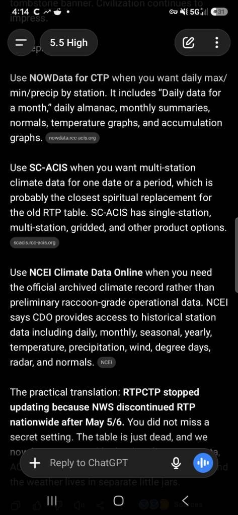
It's because they took it out to the wood shed and discontinued the product https://www.weather.gov/media/notification/pdf_2026/scn26-34_AR_ER_WR_RTP_Discontinuation.pdf The screenshot there has your best chances to find a replacement Sent from my SM-S731U using Tapatalk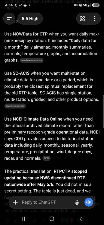
-
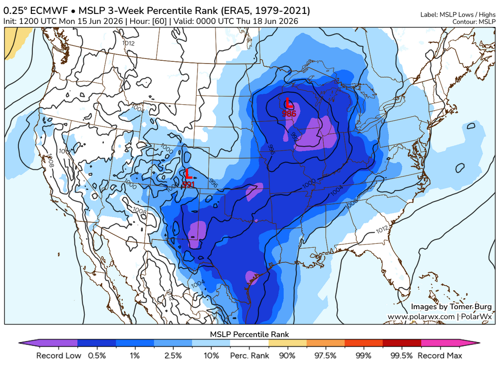
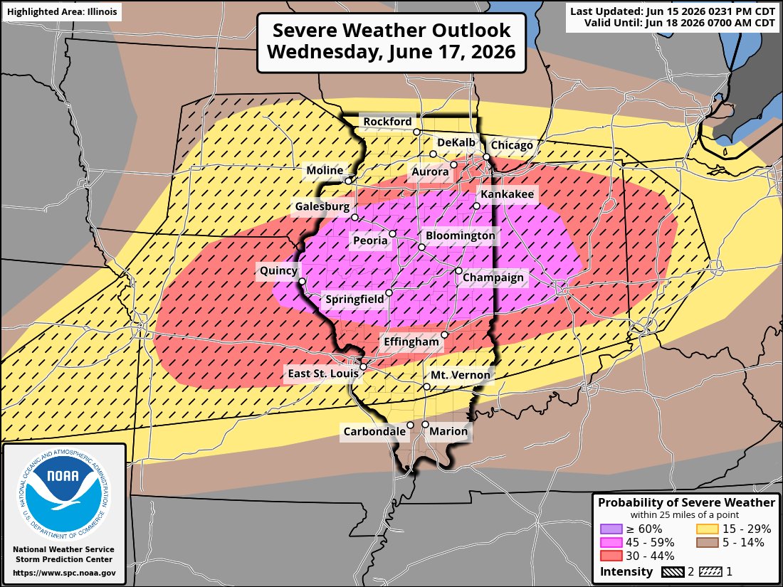
Generally when you blend a record strength 500 mb shortwave with a record strength surface low, you're going to expect some pretty anomalous outcomes assuming moisture is available, which it looks to be.
.thumb.png.63de12ab5eb22478206e6197893d2b8c.png)
-
Beautiful day with temps hovering around 80, and dews around 50.
-
I think the drought might be completely ended in a lot of Georgia by next week if this tropical low moves through as predicted
-
Woodstock, GA, (25 miles N of ATL) had 3 widely spaced thunderstorms yesterday! It looks like my home area in SAV had several rounds of significant rainfall the last 72 hours with the heaviest being ~1.1” for the 24 hours ending at 7AM today using Cocorahs as a guideline. For the last 72 hours, I roughly estimate 1.4” fell at my location, which is also near my MTD.
-
I’ll consider this a win for Bastardi if it actually becomes a TC. He predicted back in April a Gulf TC due to MJO phase 8 being bullish for Gulf TCs in June. This could provide major drought relief for a good portion of the SE! This is now Invest 90L: https://ftp.nhc.noaa.gov/atcf/btk/bal902026.dat
-
Also a large 45%

-
Zoomed in view
-

E PA/NJ/DE Summer 2026 Obs/Discussion
Birds~69 replied to PhiEaglesfan712's topic in Philadelphia Region
Sure we are This weenie notices down to the last second and it makes me happy to know soon we'll be heading in the right direction (Fall)... -
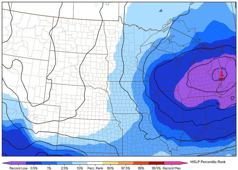
Afternoon AFD from LWX KEY MESSAGE 1...Heat and humidity returns for Thursday, along with chances for severe thunderstorms. A potent shortwave on the southern periphery of a much broader upper low over Canada will track through the Great Lakes on Wednesday night. This will force a highly anomalous area of low pressure to track across the eastern Great Lakes. In fact, this low could potentially break all-time minimum sea level pressure records for the month of June across portions of Wisconsin and Michigan as it tracks through later Wednesday into Wednesday night. Most solutions have this low tracking across southern Ontario and Quebec at around 985-990 hPa on Thursday. An unseasonably strong wind field aloft will accompany the highly anomalous low, as 850 hPa winds climb to around 30-50 knots and 500 hPa winds increase to in excess of 50 knots. Low-level south to southwesterly flow will also draw a hot and humid airmass north into the area. Temperatures are forecast to soar into the upper 80s and 90s across the bulk of the forecast area, while dewpoints increase into the mid to upper 60s. This overlap of a very hot and humid airmass with highly anomalous winds aloft raises concerns for severe thunderstorms locally on Thursday. It`s still to early to get into the finer scale details, but soundings show an environment that is very favorable for the production of damaging winds. SPC currently has the entire area outlooked with a Slight Risk for severe thunderstorms. We`ll continue to monitor this threat for severe thunderstorms over the coming days. Even outside of thunderstorms, winds should be breezy, potentially gusting in excess of 30 mph even in clear air. The combination of heat and background winds will be something that we don`t experience often here in the Mid-Atlantic.
-
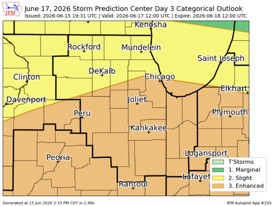
SPC expanded the enhanced north and east:
-
AI music kinda hits. dumb youtube won't let me upload as regular without adding filler
-
Record low slp
- Today
-
Central PA Summer 2026 Discussion/Obs Thread
Yardstickgozinya replied to Voyager's topic in Upstate New York/Pennsylvania
Hopefully, every thing turned out, okay with your friends. I was out catching bait with my son and didn't even peek at the radar yesterday. When I get home from work i'll look at storm paths and trajectories, but it doesn't seem like I was most likely looking at that cell. -
So much for that 2nd half of June wet pattern. Models have been overdoing the longer range for 2 months.
-

Central PA Summer 2026 Discussion/Obs Thread
Mount Joy Snowman replied to Voyager's topic in Upstate New York/Pennsylvania
Does anybody know why the CTP page that provides a summary of max/min temps and precip twice a day for the ASOS sites hasn't updated since May 5th? If it is accessible somewhere else could someone please provide that? Below is a link to the page. Thanks. National Weather Service -
If KFOK can go calm for a few hours low 40s are attainable .
-
rip champaign
-
Gorgeous day 78/ 51 . Breezy.
-

2026-2027 Super El Nino
GaWx replied to Stormchaserchuck1's topic in Weather Forecasting and Discussion
Thanks, Mitch. Indeed, “E based” can be defined in numerous ways as it’s not black and white, of course. Here are the relative anomalies for the strongest of years in 3.4 as of the closest week centered on June 10th back to 1982: 1+2 3 3.4 4 09JUN1982 -0.2 0.8 1.0 1.1 11JUN1997 3.0 1.3 0.8 0.2 12JUN2002 -0.3 0.6 0.8 0.7 10JUN2015 1.8 0.8 0.6 0.7 10JUN2026 2.1 1.0 0.9 0.7 Just looking at this period rather than model progs for fall/winter, here are my rankings of most to least E based: 1997, 2026, 2015, 2002, 1982 though 2026 is only slightly ahead of 2015 -

2026-2027 Super El Nino
bluewave replied to Stormchaserchuck1's topic in Weather Forecasting and Discussion
Some recent studies show that the local cold blob in the North Atlantic is a result of stronger winds from the more persistent +NAOs rather than a slowdown in the AMOC. Anthony Masiello @antmasiello.bsky.social · 7mo Natural variability, in low frequency states of atmospheric circulation, is becoming increasingly likely as the main explanation for the North Atlantic warming hole. Sang-Ki Lee @sklee621.bsky.social · 7mo The Atlantic's warming hole is not a sign of the AMOC weakening, a new study suggests: ocean2climate.org/2025/11/12/t... The Atlantic’s ‘Warming Hole’ Isn’t What You Think: 5 Surprising Truths From New Climate Research This blog post and the “Deep Drive” podcast on a new paper “Atmosphere-driven processes in shaping long-term climate variability in Greenland and the broader subpolar North Atlant… ocean2climate.org -
I think it was 8-10 miles north of Bel Air


.png.981588a393ec053f28cdcd9c1833d79b.png)


.thumb.gif.f92b16c631a1d15d405ed77b33f0710d.gif)

.thumb.jpg.ad3a2e31d30aff035044689b311a0540.jpg)


