
All Activity
- Past hour
-

Monday, August 31 - Thursday, September 3, 2026 Convective Episodes
WxWatcher007 replied to weatherwiz's topic in New England
I think this sums it up, folks. -

2026 Mid-Atlantic Severe Storm General Discussion
Eskimo Joe replied to Kmlwx's topic in Mid Atlantic
These repeated dying MCS's running into MD make me far more pessimistic that we get anything of substance below Mason-Dixon today. We're just working the atmosphere over too much. -
Frederick is Frederick’ing again. Another line incoming.
-
This week's drought monitor showed some more slippage in northern NC with an expansion for D3 and the reintroduction of D4 in the Triad area. Meanwhile the drought was again chipped away at the mountains and coast. Elsewhere in the south most areas remained unchanged but south of ATL has been dry lately and saw the reintroduction of moderate drought after a long break from it. Rest of Ga and SC were mostly unchanged
-
https://x.com/severeweathereu/status/2095419607100109295?s=46&t=dhcbvkjmRcyBVQtDxJ3lRg
-

2026-2027 Record-breaking El Nino
GaWx replied to Stormchaserchuck1's topic in Weather Forecasting and Discussion
The summer of 2026 ended up with the 2nd strongest summer -SOI back to 1876! Here are the 16 strongest -SOI summers. Note that while 1882 is way out of place with it being cold neutral, the rest are El Niños (with all but 1914 being moderate or stronger): 1896 (-22) strong 2026 (-21) progged super 1982 (-19) super 1882 (-18) cold neutral 1905 (-18) moderate 1997 (-17) super 1941 (-17) moderate 1940 (-16) strong 1987 (-16) moderate 2015 (-14) super 1965 (-14) super 1994 (-14) moderate 1914 (-14) weak 1977 (-14) moderate 1888 (-13) super 1972 (-12) super -
2010 was I think the hottest summer on record for Raleigh. I was in school at Clemson so I did not get to experience that here, thankfully
-
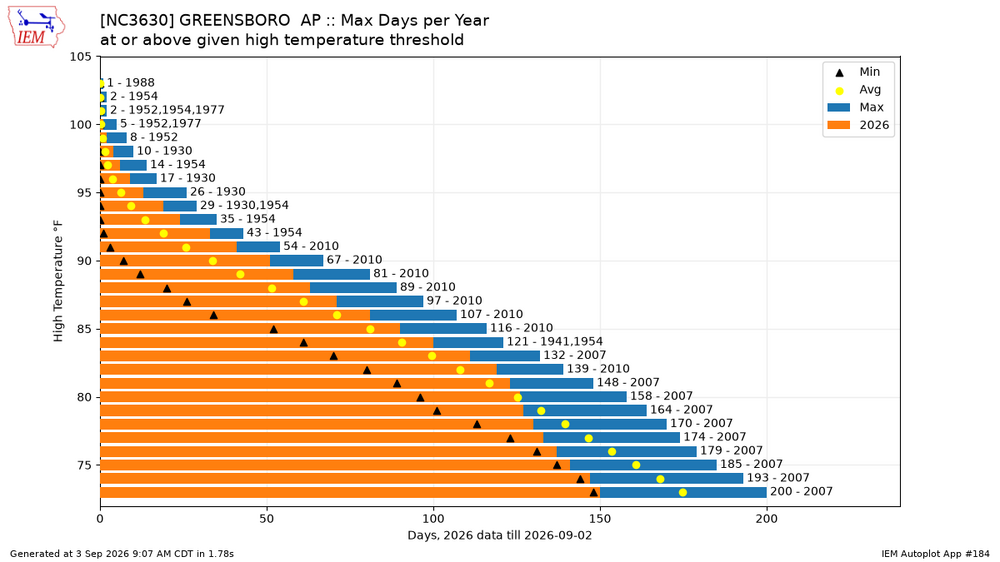
Just cloud cover and maybe some sprinkles, but that will knock down temps briefly until the weekend. It was the 3rd top 10 hottest Summer and 4th top 20 hottest Summer though within the past 5 years...
-
-
73 degrees and storming all morning here, hopefully this keeps the heat down later today.
-
.35" last night. Thought we were going to get a lot more based on the radar around midnight.
-
Yep. From ChatGPT: 2026 Raleigh Heat Metrics At-A-Glance (Year-To-Date) Days over 90°F: 65 days Days over 95°F: 33 days Days over 100°F: 6 days
-
STW through 10:30 a.m. for my yard. Radar indicated 60 mph wind gusts. Waiting….
-
u gonna get some of those remnants or is it duster days down there?
-

Mountain West Discussion
mayjawintastawm replied to mayjawintastawm's topic in Central/Western States
I've hiked in that area up to the passes in the area (though I've never done the "official Four Pass Loop") and camped by a couple of lakes. Trails are steep and rocky up to the formerly glaciated headwalls pretty much everywhere in CO, though maybe more in that area because of the rock itself. Poles are a good idea (and will help preserve your knees for future decades!) -
At some point the readout should just say fuck this!
-
Or nothing?
-
RDU did hit 100. We maxed out at 98.8 at my house, but will say the trusty car thermometer was reading over 100 and got up to 103 on the beltline pretty much my whole drive back from the office until I got into my neighborhood. I'm sure some localized areas were well over 100. Feels like walking through a bowl of hot soup this morning. This is one of the most brutal summers I can ever remember living here. Just no real extended relief from humidity since June and no sign of real fall-like weather though Sun-Tues will be a decent reprieve
-

Septorcher 2026 Discussion - Endless Summer
wxeyeNH replied to Damage In Tolland's topic in New England
.03" so far with this system -
Miserable
-

Central PA Summer 2026 Discussion/Obs Thread
Itstrainingtime replied to Voyager's topic in Upstate New York/Pennsylvania
.89" of rainfall. -

2026-2027 Record-breaking El Nino
40/70 Benchmark replied to Stormchaserchuck1's topic in Weather Forecasting and Discussion
Regardless of the total picture, there exists absolutely astronomical, extraordinarily high potential during shorter intervals that belies what should be a mild seasonal mean....the devil is in the details and it's easy to miss the period when all hell broke loose when you only view a snapshot composite of a winter's life. Almost akin to considering a middle-aged guy like me....46 yrs, old, decent career, 4 beautiful children and an aggregate of circumstances that embodies a ho-hum mid-life...sure, but when viewing a 46-year composite mean, it's easy to miss the US Marine that collected 2 OUIs and came within a toad's whisker of having it all end long before any of my kids were even so much as a glint in my eye. -

Central PA Summer 2026 Discussion/Obs Thread
canderson replied to Voyager's topic in Upstate New York/Pennsylvania
It’s an ominous sky out there right now -
September 3 1989: An early afternoon thunderstorm dropped 1 3/4 inch hail in Stearns and Morrison Counties. 1980: An F2 tornado results in $2.5 million in property damage, followed by an F3 tornado causing $25 million in damages in Stearns County. 1970: The record-setting hailstone fell that made Coffeyville, KS famous. It had a circumference of 17.5 inches and weighed 1.67 pounds. 1917: An earthquake is felt from Staples to Brainerd. For Thursday, September 3, 2026 1821 - A hurricane made landfall at Long Island, near Kennedy Airport, then moved through western Connecticut. The hurricane produced a record tide at New York City. (David Ludlum) 1953 - The temperature at Erie PA reached 99 degrees, and Stroudsburg PA established a state record for September with a reading of 106 degrees. (The Weather Channel) 1961 - Denver, CO, received 4.2 inches of snow, their earliest snow of record. (Sandra and TI Richard Sanders - 1987) 1970 - During the early evening hours, in the midst of a severe hailstorm at Coffeyville KS, a stone 17.5 inches in circumference and nearly two pounds in weight was recovered. It was the largest measured hailstone in U.S. weather records. Average stone size from the storm was five inches in diameter, with another stone reportedly eight inches in diameter. (David Ludlum) 1987 - Temperatures dipped into the 40s and 50s for morning lows across much of the eastern half of the country, with eleven cities reporting record lows for the date. Pellston MI tied Gunnison CO for honors as the cold spot in the nation with a low of 30 degrees. Smoke from forest fires darkened skies in southern Oregon and northern California. (The National Weather Summary) 1988 - Sixteen cities in the northwestern U.S. reported record high temperatures for the date. Highs of 89 degrees at Stampede Pass WA and 116 degrees at Redding CA established records for the month of September. Readings of 98 degrees at Spokane WA and 100 degrees at Yakima WA equalled records for September. (The National Weather Summary) 1989 - Thunderstorms developing ahead of a cold front produced severe weather from Minnesota to Nebraska during the day and evening. Evening thunderstorms in Nebraska produced wind gusts to 100 mph at Valentine and Gretna, and produced baseball size hail at Lewellen. Thunderstorms in Arizona produced 2.20 inches of rain in forty minutes at Green Valley, and wind gusts to 60 mph. Eight cities in Texas and Florida reported record high temperatures for the date, including Victoria TX and San Antonio TX, each with a reading of 102 degrees. (The National Weather Summary) (Storm Data) Observances: 3 Thu Signing of the Treaty of Paris 3 Thu National Skyscraper Day 3 Thu National Welsh Rarebit Day 3 Thu Skyscraper Day 3 Thu US Bowling League Day
-

2026 Mid-Atlantic Severe Storm General Discussion
adelphi_sky replied to Kmlwx's topic in Mid Atlantic
Good sleeping weather. I hope we can at least get some thunder. That's been missing lately. Had a few good boomers this summer though. But just a few.















