All Activity
- Past hour
-
Windy day.
-

2026 Mid-Atlantic Severe Storm General Discussion
SnowenOutThere replied to Kmlwx's topic in Mid Atlantic
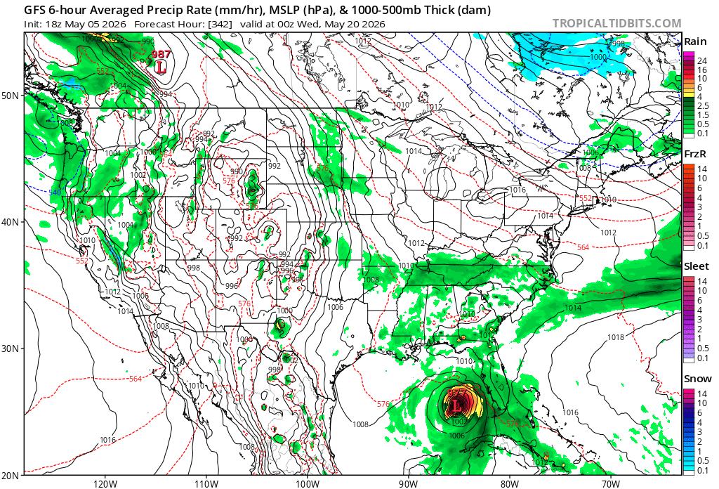
From LWX: Honestly a bit surprised tomorrow got such a long writeup but the increasing risk of storms became high enough to rule out a hike in Shenandoah tomorrow. Recent guidance has trended a bit slower with the front`s progression through the area, which could potentially allow for a bit more destabilization tomorrow afternoon. As a result, the trend has also been slightly upward with CAPE values. Much of the destabilization appears to occur as a result of low-level moisture convergence in the vicinity of the surface front, which causes dewpoints to rise into the low to mid 60s. That being said, there is still a fair amount of uncertainty with respect to how much destabilization occurs, and also the areal coverage of storms that form. Shear certainly won`t be lacking tomorrow, with most soundings showing long, straight hodographs, with around 60 knots of effective bulk shear and over 100 knots of shear in the cloud bearing layer. So, if storms form, there is a conditional threat for supercells. The 12z HRRR for example, hinted at this possibility, with weak UH tracks. The thermodynamic environment is a bit odd, and casts uncertainty with respect to what hazards storms could potentially produce, if they occur at all. Model soundings show long, straight hodographs, which would normally be supportive of hail production. However, profiles are nearly saturated and moist-adiabatic at low-levels, with a considerable amount of the CAPE below the freezing level, which is unfavorable for hail production. Winds in the mid-upper levels are very strong, but aren`t overly impressive just above the surface. And model soundings show a good amount of dry air in the mid-levels (which yields DCAPE values around 700 J/kg), but very moist air at low-levels and poor low-level lapse rates, which would be unfavorable for transporting higher momentum air down from aloft. Machine learning guidance is downplaying the potential for severe thunderstorms, and SPC currently has us outlooked in general thunder. However, tomorrow is at least worth monitoring from a severe thunderstorm perspective given the CAPE/shear combination that could potentially be in place (high end scenario of around 1000 J/kg of MLCAPE, and 60 knots of effective bulk shear). -
-
Warmer global temps = more instability = more wind
-
-
Euros been hinting at that too
-
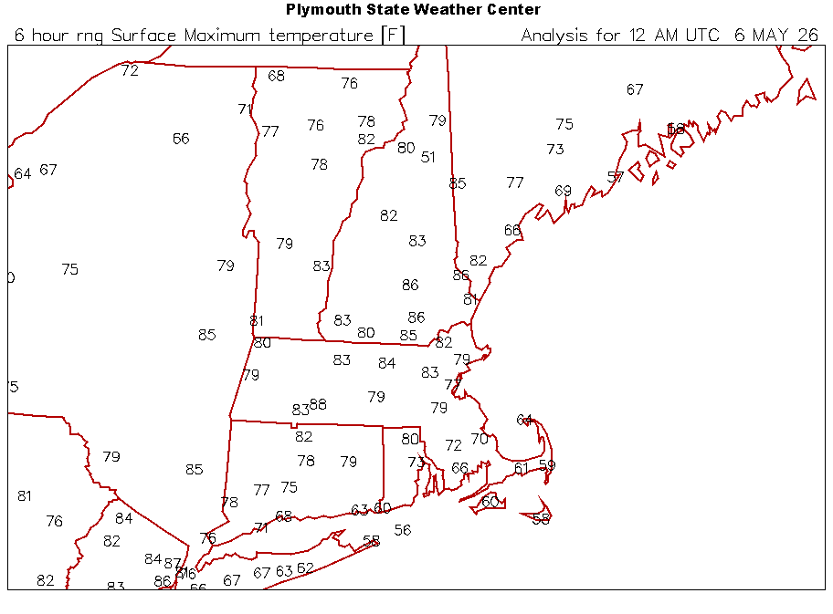
Down to 60 at my location with the strong southerly wind off the water while Staten Island and Newark are at 79
-
Yep we could really miss out east of the Apps. Especially closer to Virginia.
-
High of 70. Nice day
-
A stunner of an evening, love this breeze.
-

2026-2027 Strong/Super El Nino
roardog replied to Stormchaserchuck1's topic in Weather Forecasting and Discussion
Yeah. I’m not sure it’s showing a +PDO like he says. - Yesterday
-
Time to fire off the tropical thread? (JK)
-
If we get a period of HL blocking, in a strong Nino a big winter storm is still possible-even the lowlands. So ofc the western highlands could get 'crushed'. They typically get impressive snow regardless of the overall pattern, unless cold air ingress from Canada is completely shut off.
-

Central PA Spring 2026 Discussion/Obs Thread
mahantango#1 replied to Voyager's topic in Upstate New York/Pennsylvania
84 was the high today. Nice day, wind could have been calmer. -
El Nino is trending on the X. Lots of posts like this. We are doomed!!
-
Would the mountains in WV get crushed with the storm track or is it even warm at 4000ft?
-
She coming
-
Where are the winds? Thought we were gonna see yuge gusts?
-

2026-2027 Strong/Super El Nino
snowman19 replied to Stormchaserchuck1's topic in Weather Forecasting and Discussion
^ “Worth noting that while the ECMWF has had a high bias in some ENSO forecasts in past springs, so far the forecasts from earlier this spring are verifying quite nicely with the rapid evolution towards +ENSO. In past bust cases (like 2017 and 2022), the warm bias was already evident by May. That doesn't appear to be the case this time around. Doesn't mean the model is perfect, but there's also no evidence of a major bust this time around.” -
I'm wondering at what point do we call our area the New Windy City? I'm surprised at the low dews today...was thinking it would be a humid 80 with the rain chances tomorrow. It goes to show how quickly we can flip flop between dry and humid.
-

2026-2027 Strong/Super El Nino
GaWx replied to Stormchaserchuck1's topic in Weather Forecasting and Discussion
They’re not mentioning that the Euro has had a warm bias though it’s lowest for an actual Nino (few ticks on average with a couple almost perfect). May run has almost never verified too cool. They’re probably not aware of this bias. You won’t be less you study the verifications going back aways like I did. Of course even a warm bias doesn’t mean it will definitely verify colder. -
The models are backing off a lot on precipitation. Everything is dropping south. Where is this in the freaking winter.
-
I know.. ugh. Trying to softwash a 40' tall house in the never ending 30 mph wind is always a real pain in the a$$. Ever since March 1 it's been cold and windy or hot and windy lol
-
I have to say if anything these past few years has shown me is, if it is labeled drought tolerant it will go into my yard. My front garden of sedums, day lilies and catmint are exploding in full bloom. And my Knock out Rose Bush is covered with buds. Have some Black Eyed Susans coming up in my container. I put them in there so they don’t over spread.
-
82f for high. Still in denver. Snow stacking up in Estes Park at 10k. 16". Was wet snow in ft. Collins. Sent from my SM-S921U using Tapatalk