All Activity
- Today
-

2024-2025 La Nina
40/70 Benchmark replied to George001's topic in Weather Forecasting and Discussion
1965-1966 was my main analog last year, but the sensible result was worlds different. -

Summer 2024 Medium/Long Range Discussion
Chicago Storm replied to Chicago Storm's topic in Lakes/Ohio Valley
They’re already warm/well above average in the extended. -

2024-2025 La Nina
so_whats_happening replied to George001's topic in Weather Forecasting and Discussion
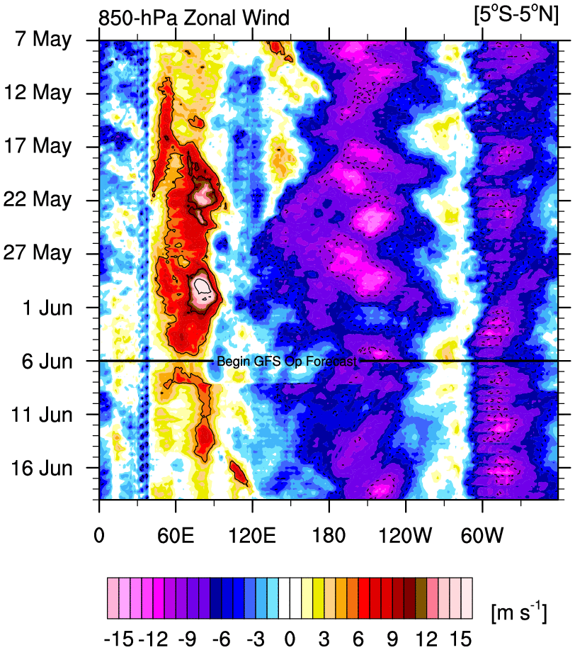
Anyway here is a little update on the subsurface for the developing La Nina. Just about a months worth of visuals spanning about 4 days in between images. Ill continue this as we go into fall and sporadically update. Also a look a hovmollers with finally a weak moving MJO wave..thumb.gif.64cfe09f65ce5c96793b5cb94ed43921.gif)

-
2024-2025 La Nina
so_whats_happening replied to George001's topic in Weather Forecasting and Discussion
Is it possible the reduction of sulfur based fuels are finally coming home to roost? China stopped using heavily sulfur based fuels back in 2017 so it is very possible it will start to play catch up to the extreme levels we have seen in the Atlantic and continually grow with time. Time will tell of course. This will largely create even more disconnect between the tropics and subtropics over time and could very well start to show a lower overall named storm/ hurricane/typhoon count as we go through time as the atmosphere tries to rebalance itself out in this new regime. Just some food for thought while things are still kind of early for the season. -
Looks like some could see some storms tonight. Sent from my SM-G998U using Tapatalk
-
 HIPPYVALLEY changed their profile photo
 -
We will get a few 90's days mid-month but I'm thinking moderate heat with a lot of mid-80's. I'm thinking precipitation may become an issue for SNE with mid-summer heat and little rain. I'll take hot and dry tho'... just need to water the veggie garden more.
-
Already sweltering in the Southwest, glad I don't live there.
-

2024-2025 La Nina
Stormchaserchuck1 replied to George001's topic in Weather Forecasting and Discussion
I think you have done great the last 2 years, but don't fall in the trap of thinking "this is X std's above normal so it has to even out". I think there is a very clear reason for the +WPO of late, being the La Nina state in the Pacific since about 1998 (leading to -PDO conditions). The -WPO/-EPO Winters have been more +pdo during that time. The real trend is how the RNA of late has been gaining steam, part of that being how we saw a N. Pacific High most of the time in a Strong El Nino this past Winter, which only happened in 65-66 and 72-73, at the peak of that -pdo cycle. It does open the door for -NAO potential though, I think. You were the only that originally pointed out the PDO has a higher correlation: https://ibb.co/hWtdb2W +0.6 correlation over the Deep South! https://ibb.co/kyH3kzd +0.35 peak correlation -
2024-2025 La Nina
Stormchaserchuck1 replied to George001's topic in Weather Forecasting and Discussion
If I had to venture a guess for the upcoming Winter right now, it would look like this. https://ibb.co/4PqH6ZK -
Nasty heat wave on that GFS run
-
Note - long post Public Information Statement National Weather Service Baltimore MD/Washington DC 943 PM EDT Thu Jun 6 2024 ...NWS Damage Survey for 06/05/24 Tornado Event... .Overview...On the afternoon and evening of Wednesday June 5th, a warm front slowly lifted northeast across the eastern Panhandle of West Virginia into northern Virginia as well as central and northeastern Maryland. At the same time, low pressure tracked along the warm front causing severe thunderstorms and tornadoes to develop. At this time, the National Weather Service is confirming seven tornadoes in this report. Information is still being collected which could result in additional confirmations in the days ahead. .Inwood WV Tornado... Rating: EF-0 Estimated Peak Wind: 75 mph Path Length /statute/: 0.85 miles Path Width /maximum/: 65 yards Fatalities: 0 Injuries: 0 Start Date: June 05 2024 Start Time: 4:04 PM EDT Start Location: 2 SSE Inwood / Berkeley County / WV Start Lat/Lon: 39.3375 / -78.0330 End Date: June 05 2024 End Time: 4:08 PM EDT End Location: 1 SE Inwood / Berkeley County / WV End Lat/Lon: 39.3506 / -78.0298 Staff from the National Weather Service Baltimore/Washington Weather Forecast Office conducted a ground survey of storm damage in Inwood WV that occurred on Wednesday afternoon, June 5, 2024. NWS Doppler Radar in Sterling, Virginia showed a rotating severe thunderstorm that developed a tornado. The tornado touched down south/southeast of Inwood in a field where tall grass could be seen disturbed in a rotating pattern. The tornado proceeded to move north across a cow pasture where a line of trees contained tree damage with large branches broken off. The tornado then tracked north across the field, where additional tree damage and shingle damage occurred along Emery Lane. The tornado continued north towards Lucy Drive where gutter damage and additional tree damage occurred. The tornado then crossed Lucy Drive where large tree branched were broken off. It is believed that the tornado lifted before reaching Middleway Pike as no further damage was observed past that point. The National Weather Service would like to thank the citizens of Inwood for their help and support in conducting this survey, and providing storm damage reports to the National Weather Service. .Leesburg VA Tornado... Rating: EF-1 Estimated Peak Wind: 95 mph Path Length /statute/: 1.0 miles Path Width /maximum/: 125 yards Fatalities: 0 Injuries: 0 Start Date: June 05 2024 Start Time: 6:42 PM EDT Start Location: 3 N Leesburg / Loudoun County / VA Start Lat/Lon: 39.1655 / -77.5648 End Date: June 05 2024 End Time: 6:43 PM EDT End Location: 4 NNE Leesburg / Loudoun County / VA End Lat/Lon: 39.1767 / -77.5516 Staff from the National Weather Service Baltimore/Washington Weather Forecast Office conducted a ground survey of storm damage that occurred north of Leesburg on Wednesday, June 5, 2024. NWS Doppler Weather Radar in Sterling, Virginia showed a rotating severe thunderstorm that developed a tornado. Radar also showed a tornado damage signature due to lofted debris from the tornado as it was occurring. The tornado touched down southwest of Garriland Drive, north of Leesburg, in a wooded area where broken trees could be seen. The tornado proceeded North/northeast across Garriland Drive, south of the intersection of Garriland Drive and Turning Leaf Lane, where several trees were uprooted in different directions and minor vinyl damage and window damage could be seen. The tornado then crossed over Garriland Drive again into a field where tree damage could be seen in the distance. Garriland Drive turns north at this point where the tornado crossed it at London Council Lane. Near London Council Lane, a small tree was uprooted and small branches had been snapped off. The tornado continued northeast towards Springrun Lane where a small shelter had the plastic roof ripped off. Across Springrun Lane, tree damage could be seen going into the woods, but was not found any further beyond this point. The National Weather Service would like to thank the citizens of Leesburg for their help and support in conducting this survey, and providing storm damage reports to the National Weather Service. .Central Montgomery County MD Tornado... Rating: EF-1 Estimated Peak Wind: 105 mph Path Length /statute/: 12.0 miles Path Width /maximum/: 125 yards Fatalities: 0 Injuries: 5 Start Date: June 05 2024 Start Time: 7:14 PM EDT Start Location: Poolesville Start Lat/Lon: 39.1302/-77.3852 End Date: June 05 2024 End Time: 7:42 PM EDT End Location: Gaithersburg End Lat/Lon: 39.1391/-77.1854 National Weather Service Baltimore/Washington Weather Forecast Office staff conducted a ground survey of storm damage that occurred in central Montgomery County MD on the evening of Wednesday, June 5, 2024. A mini-supercell thunderstorm formed southeast of the first tornado that impacted Leesburg, VA, west of Poolesville, MD. Videos of funnel clouds near John Poole Middle School were provided by weather spotters. The first damage surveyed was at Tudor Farm along Whites Ferry Road (MD-107). About 2 dozen pine trees with trunk diameter exceeding two feet were snapped or uprooted at this location, laying in various directions. Media reported collapse of doors to a barn on the property. From this location, the tornado lifted before dropping again in the vicinity of the 16000 block of Darnestown Road (MD-28). Here, about a dozen softwood trees were snapped and uprooted, falling in differing directions. These downed trees caused the closure of Darnestown Road for a period of time overnight. The tornado continued on the ground for about 0.5 miles, where additional damage was observed along and near White Ground Road. Here, many pine trees were snapped, with one pine tree debarked of about half of its bark on its remaining trunk. The storm proceeded east across Seneca Creek State Park. Staff at the Washington Suburban Sanitary Commissions (WSSC) Seneca Water Resource Recovery Facility witnessed the tornado moving west-to-east directly adjacent to the south of their facility where power lines leading to the facility were snapped causing the facility to switch to backup power. After its trek south of the facility, it produced large broken branches that fell onto Great Seneca Highway (MD-119), partially blocking the roadway. The storm continued east and entered the City of Gaithersburg. The first damage surveyed was along Desellum Avenue north of Gaithersburg High School. Here, pine trees were snapped, with large limbs downed. A pair softwood trees, approximately 30 yards apart, were snapped and fell directly towards each other, evidence of a tornado. The storm proceeded towards Old Town Gaithersburg, depositing a large limb on top of St. Martin of Tours Church at the intersection of South Summit Avenue and South Frederick Avenue (MD-355). The housing development directly east of the Gaithersburg City Hall was particularly hard-hit, with seven houses being condemned from trees and branches falling onto them. One large oak tree with a trunk of about three feet was uprooted, and fell into a house on Dogwood Drive, where five occupants were injured and transported to the hospital. Several other trees were uprooted including one in the 200 block of Rolling Road, along with numerous large branches downed. One resident interviewed said they heard the Tornado Warning on their phone about three minutes before damage occurred near them. Once notified, their family took action to go to the basement of their home to remain safe. This was the last area of concentrated damage in Montgomery County; it should be noted there may have been additional sporadic damage east of the City of Gaithersburg as the storm continued its eastern heading towards Columbia, MD, where it produced additional damage. The National Weather Service Baltimore/Washington Weather Forecast Office acknowledges the assistance of the Montgomery County Office of Emergency management and Homeland Security, Montgomery County Department of Health and Human Services, WSSC Water, and the City of Gaithersburg in helping conduct and provide information to this storm survey. .Columbia MD Tornado... Rating: EF-1 Estimated Peak Wind: 95 mph Path Length /statute/: 1.0 miles Path Width /maximum/: 75 yards Fatalities: 0 Injuries: 0 Start Date: June 05 2024 Start Time: 8:31 PM EDT Start Location: Columbia Start Lat/Lon: 39.2150/-76.8220 End Date: June 05 2024 End Time: 8:33 PM EDT End Location: Columbia End Lat/Lon: 39.2154/-76.8049 National Weather Service Baltimore/Washington Weather Forecast Office staff conducted a ground survey of storm damage that occurred in the Long Reach village of Columbia, MD, on the evening of Wednesday, June 5, 2024. Damage was reported in Columbia, MD, in Long Reach village at Phelps Luck Drive, along High Tor Hill, and the 5600 block of Waterloo Road. First report of damage was at Phelps Luck Drive. A townhouse development near the intersection of High Tor Hill and Tamar Drive experienced concentrated tornadic damage. Here, approximately two dozen trees were snapped or uprooted, falling in various directions. About a dozen cars parked in the townhouse community parking lot were damaged by trees or large limbs falling onto them. Roofing fascia was peeled off of one townhome. Damage was more intermittent but present heading north toward the 5600 block of High Tor Hill. Finally, tree damage was also reported at the 5600 block of Waterloo Road. The National Weather Service Baltimore/Washington Weather Forecast Office acknowledges the assistance of the Howard County Office of Emergency Management in helping conduct and provide information contained within this storm. .Southern Baltimore County MD Tornado... Rating: EF-1 Estimated Peak Wind:105 MPH Path Length /statute/: 2.4 Miles Path Width /maximum/: 175 Yards Fatalities: 0 Injuries: 0 Start Date: June 05 2024 Start Time: 8:45 PM EDT Start Location: Arbutus / Baltimore County Maryland/ MD Start Lat/Lon: 39.23 / -76.71 End Date: June 05 2024 End Time: 8:52 PM EDT End Location: Halethorpe / Baltimore County / MD End Lat/Lon: 39.25 / -76.67 National Weather Service Baltimore/Washington Forecast Office staff conducted a survey of storm damage that occurred in southern Baltimore County on Wednesday, June 05, 2024. NWS Doppler Weather Radar in Sterling, Virginia showed a rotating thunderstorm that developed a tornado based on this survey. Weather spotters and residents reported a tornado touchdown in the vicinity of the I-95 and I-195 interchange around 8:45 PM EDT. This was confirmed with ground reports of several large tree trunks twisted and snapped in the vicinity of Riverchase Apartments along Selford Road and Deer Run Court. The tornado continued east northeast along a narrow path toward Friendship Road and Francis Ave. Multiple trees and wires were down along this route in a confluent pattern. The most notable was a large oak tree snapped midway up the trunk. The tree ended up laying in the north-northeast direction onto two cars and a house nearby. An additional large oak tree and its root ball were laying 500 feet nearby closing off Friendship Road. Beyond this point, the tornado continued east northeast between Francis Avenue and Ingate Terrace. Additional large trees were sheared off along with large root balls toppled. Numerous power and phone lines were down as well with BGE and Verizon crews assessing and repairing the damage. Similar damage was observed as the tornado moved east southeast toward Elm and Oakland Road. Several large trees were snapped midway along Elm Road, Huntsmoor Road, Oakland Road, and Ashbourne Road. Wires were down as well with one power pole twisted at its base at the intersection of Oakland Road and Elm Rd. Beyond this point the path widened a bit with two medium spruce trees down along Oregon Avenue and several large branches along Carville Avenue. The tornado proceeded to lift and cycle as it crossed US-1 at I-95 and Potomac Avenue around 7:48 PM. The storm continued 1.4 miles east northeast toward Halethorpe, MD where an additional touchdown was noted around 8:50 PM EDT. This was confirmed with several damage reports in the vicinity of the 3600 block of Commerce Drive and Washington Boulevard and Lansdowne Road. Multiple trees were snapped along a narrow path from the Home Depot over toward Alside Building Materials and Amazon HQ. The most notable damage was along Robert A Young Way between Alside Products and Amazon HQ. Four heavy overhead doors were blown out of the distribution warehouse along with pieces of the awning and roofing material removed from the Alside building. Several trees were also sheared at the canopy top within this same area. Additional large trees were taken down behind the LA- Fitness and Store-it storage facility along Washington Boulevard. The damage was a bit broader in this area and most likely the end point to where the tornado finally lifted. Radar indicated the circulation clearing this point around 8:52 PM EDT. The National Weather Service Baltimore/Washington Forecast Office would like to thank the Baltimore County Office of Emergency Management for providing helpful information and assisting in the survey today. .Middle River MD Tornado... Rating: EF-1 Estimated Peak Wind: 105 MPH Path Length /statute/: 0.2 Miles Path Width /maximum/: 110 yards Fatalities: 0 Injuries: 0 Start Date: June 05 2024 Start Time: 8:57 PM EDT Start Location: Middle River Start Lat/Lon: 39.34 -76.40 End Date: June 05 2024 End Time: 8:58 PM EDT End Location: Middle River End Lat/Lon: 39.34 -76.40 National Weather Service Baltimore/Washington Forecast Office staff conducted a ground survey of storm damage that occurred in southeast Baltimore County on Wednesday, June 05, 2024. NWS Doppler Weather Radar in Sterling, Virginia showed a rotating thunderstorm that developed a tornado based on the survey. The circulation developed just to the south of Essex, MD at 8:43 PM EDT before racing north and strengthening toward Martin State Airport around 8:57pm. This is where a notable debris signature started to show up on radar as the storm pushed north-northeast. This signature was confirmed with ground reports of multiple mobile homes damaged in the Williams Estates area as the strongest winds pushed through. The damage path was fairly narrow and short lived. Most of the damage included the removal of underpinning from several single and double wide mobile homes in the Williams Estates community. This included several mobile homes along Wagon Train Road and Roundup Road as well as Cowhide Circle. Carports, sheds, and even a trampoline were tossed around the neighborhood as well. Several trees were also snapped and turned in several different directions along Roundup Road and Cowhide Circle. The most notable damage was between Dahlia Lane and Roundup Road. This where the height of the circulation looks to take place right around 8:58 PM EDT. Within this area there were two double wide mobile homes with significant damage. One of the mobile homes had underpinning removed from two sides of the building with the windows completely blown out and a shed tossed 50 yards in the opposite direction from its foundation. The resident who owns this home had roughly 30 seconds of video showing the tornado as it passed through. He recalled a loud boom which was most likely the shed being tossed from the foundation to the other side of the residence. Pieces of the shed and other debris were impinged into the side of the mobile home as well. The neighboring double wide mobile home was also missing a majority of its underpinning along with several shingles and shingle material off the roof of the structure. Strapping on both units appeared to be secured with no other distinct structural damage to be observed. Beyond this point, the tornado continued toward Roundup Road and Cowhide Circle where the path widened. Much of the same damage was noted, but to a lesser extent with underpinning and shingles removed from several mobile homes in the area. The tornado continued toward the back of Cowhide Circle where it eventually lifted. No additional damage was found beyond this point nor any injuries reported. The National Weather Service Baltimore/Washington Forecast Office would like to thank the Baltimore County Office of Homeland Security and Emergency Management for providing helpful information and assisting in the survey today. .Eldersburg MD Tornado... Rating: EF-0 Estimated Peak Wind: 85 mph Path Length /statute/: 4.4 miles Path Width /maximum/: 100 yards Fatalities: 0 Injuries: 0 Start Date: June 05, 2024 Start Time: 7:59 PM EDT Start Location: 2 NNW of Eldersburg / Carroll County / MD Start Lat/Lon: 39.4259 / -76.9717 End Date: June 05, 2024 End Time: 8:13 PM EDT End Location: 1 NE of Gamber / Carroll County / MD End Lat/Lon: 39.4726 / -76.9151 On the evening of Wednesday, June 5, 2024, an EF-0 tornado touched down 2 miles north-northwest of Eldersburg, Maryland. The National Weather Service conducted a damage survey and noted an initial area of tree damage near the intersection of Tanglewood Drive and Covington Court. A rotational damage signature was evident as tree damage was pointed in opposite directions. The tornadic storm continued its track toward the northeast with additional damage observed along Bartholow Road near Sarah Drive. This included multiple large trees which were uprooted, one of which fell onto a house. Further damage was noted up the road just north of the intersection of Bartholow Road and Cherry Tree Lane. Dozens of trees had large sections and branches snapped off and topped. Observed tree damage was spread out into multiple directions. Several minutes later, the tornado passed over Morgan Run before causing additional damage to the Lakeland Heights area. A home was seen with siding and shingle damage near Sun Berry Court and Lake Forest Court. Multiple large broken tree branches were noted behind the home. A few trees were damaged along Legacy Drive. The damage signature to the northeast became more intermittent in nature as the tornado began to weaken. By 8:13 PM EDT, the final damage point was noted about 1 mile northeast of Gamber MD. Along Pin Oak Drive, a mid-sized tree was uprooted with multiple downed tree branches. Thereafter, the circulation dissipated while approaching MD State Route 140. No damage was noted along Route 140. A circulation evident on NWS Doppler weather radar corroborated this track as well. The National Weather Service would like to thank the Carroll County Emergency Management Division for their assistance with this damage survey. && EF Scale: The Enhanced Fujita Scale classifies tornadoes into the following categories: EF0.........65 to 85 mph EF1.........86 to 110 mph EF2.........111 to 135 mph EF3.........136 to 165 mph EF4.........166 to 200 mph EF5.........>200 mph NOTE: The information in this statement is preliminary and subject to change pending final review of the events and publication in NWS Storm Data. $$
- 964 replies
-
- 4
-

-

-
- severe
- thunderstorms
- (and 5 more)
-
Typical Tuesday morning quarterbacking. Locking the barn door after the horse is gone, etc. etc. etc.. I get that people are upset because the kids are being killed but the meteorologists did not do it, the weather did. The general public basically ignores storms as long as people are not being killed. But then suddenly they get their knickers in a twist when things take a sudden turn.
-
Thunderstorm here. 1.50” on the day.
-
Sixers need a Porzingis type. A seven-foot Lithuanian mofo who probably was deadlifting taxi cabs before being potty trained. Although a Doncic wouldn't be bad, either. You know what lends to quick feet? Not knowing if your next step is on a landmine.
-
Looking NE from the Pentagon Sheraton.
-
My forecasts actually seem to be getting more traction each year. I don't have a website, a Facebook, or anything like that. It's just one link posted here and on Twitter, but I get several thousand reads, or at least views now. I try not to post on here more than 1-3 times per day, as I consider it a waste of time in most respects. So I think the low interactions when I post my forecasts are more about me not posting too much than anything else. I could easily see the US (lower 48 anyway) average +3 to +10 for the winter, with a cold spot from Billings to San Francisco, but I really have no idea yet. It's too early. The global upper level pattern that matches with SSTs for JJA or JAS will be pretty telling. That combo almost always rolls forward correctly.
-
-
Thankfully we won't be getting hoodie updates from @nycwinter
-
Just got another quick 1/4 inch of rain, today total 1.70
-
Records: Highs: EWR: 97 (2021) NYC: 98 (1925) LGA: 95 (2021) JFK: 90 (1968) Lows: EWR: 43 (1945) NYC: 47 (1945) LGA: 49 (1945) JFK: 51 (2000) Historical: 1816 - The temperature reached 92 degrees at Salem MA during an early heat wave, but then plunged 49 degrees in 24 hours to commence the famous year without a summer . (David Ludlum) 1816: The temperature reached 92 degrees at Salem, Massachusetts during an early heat wave, but then plunged 49 degrees in 24 hours to commence the famous "year without a summer." Snow fell near Quebec City, Quebec Canada from the 6th through the 10th and accumulated up to a foot with "drifts reaching the axle trees of carriages." 1894 - One of the greatest floods in U.S. history occurred as the Williamette River overflowed to inundate half of the business district of Portland OR. (David Ludlum) 1894: One of the greatest floods in U.S. history occurred as the Willamette River overflowed to inundate half of the business district of Portland, Oregon. The river crested at 33.5 feet, the worst flood ever recorded in the city. 1975 - A tornado, reportedly spinning backwards (spinning clockwise), was sighted near Alva, OK. (The Weather Channel) 1977 - Severe thunderstorms with large hail and winds to 100 mph caused one million dollars damage around Norfolk, VA. A forty-two foot fishing boat capsized near the Chesapeake Bay Bridge Tunnel drowning 13 of the 27 persons on board. (The Weather Channel) 1987 - Thunderstorms in southern California produced one inch hail at Mount Pinos, and marble size hail at Palmdale. Thunderstorms in southeastern Arizona produced heavy rain leaving some washes under four feet of water. Six cities in the north central U.S. reported record high temperatures for the date as readings soared into the upper 90s. (The National Weather Summary) (Storm Data) 1988 - Seventeen cities in the north central U.S. reported record high temperatures for the date, including Williston ND with a reading of 104 degrees. Thunderstorms in Florida produced wind gusts to 65 mph which damaged two mobile homes northwest of Melbourne injuring six people. (The National Weather Summary) 1989 - Thunderstorms developing during the late morning hours produced severe weather through the afternoon and night. Thunderstorms spawned 13 tornadoes, and there were 154 reports of large hail and damaging winds. A strong (F-3) tornado injured six persons at Lorenzo, TX, and thunderstorm winds gusting to 100 mph killed one person at Glasscock City, TX. Softball size hail was reported at Lipscomb and Glen Cove TX. (Storm Data) (The National Weather Summary)
-
0.40" Fairly short downpours . BTW... ran AC first time this year, with DP of 75.
-
nice little cold front passage tonight, beautiful outside with the breeze
-
Turning up the heat it appears
-
Highs: ACY: 88 EWR: 87 PHL: 87 BLM: 86 New Brnswck: 86 TEB: 85 TTN: 84 JFK: 83 LGA: 83 NYC: 81 ISP: 80
.gif.5ebc6cea7ad045c4b060f2aff9d9eacc.gif)