All Activity
- Past hour
-
Two fooking inches of ice. Damn. That's going to be very, very bad. Bad, bad Leroy Brown. Baddest accretion in the whole damn town.
-

Richmond Metro/Hampton Roads Area Discussion
chris624wx replied to RIC Airport's topic in Mid Atlantic
That's just the amount for the next threat. -

“Cory’s in LA! Let’s MECS!” Jan. 24-26 Disco
Chrisrotary12 replied to TheSnowman's topic in New England
Just realized that we are still 72 hours from first flakes. So much time for things to go wrong improve more! -
Doesn’t get much more favorable than that tbh from a large scale pattern standpoint. That blocking is incredible.
-

Pittsburgh/Western PA WINTER ‘25/‘26
colonel717 replied to Burghblizz's topic in Upstate New York/Pennsylvania
Something to consider is will there be arctic front enhanced snows. Could help enhance totals; just for whom is to be determined. I'm sure that will help in the Laurels. -
.thumb.jpeg.406ecda2eec9e267302c22b9f128fe3c.jpeg)
“Cory’s in LA! Let’s MECS!” Jan. 24-26 Disco
kazimirkai replied to TheSnowman's topic in New England
Not Albany and New York yet, interestingly. Guess they're still less certain despite NBM outputs -

Possible Record Breaking Cold + Snow Sunday 1/25 - Tuesday 1/27
Stormlover74 replied to TriPol's topic in New York City Metro
I like this map right now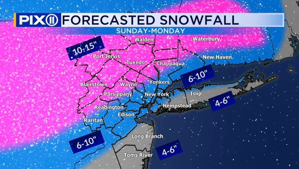
-

Southern MD / Lower Eastern Shore weather discussion
csnavywx replied to PrinceFrederickWx's topic in Mid Atlantic
Run to run variability has calmed down since 00Z last night and while I think we get a bit more adjustment south/slower, it's probably not going to be enough to save the eastern shore from changing over to all rain at this point. Enjoy the front-end thump, it'll probably only last a few hours before flipping to sleet and (briefly) ZR. Inshore is going to have a rough time of it, especially immediately away from the Bay. Hopefully we get near or just above freezing here late Sunday and at least pause the icing before it starts back up overnight. 3-6" Eastern Shore + 1" sleet, then brief freezing rain to rain; DE side will get more snow (add an inch or two) before changeover to sleet. 4-9" inshore southern MD, + 1" sleet, then 0.25-0.75" ZR A band of heavy convective rain showers is looking increasingly possible overnight Sunday into early Monday morning. If the coastal has developed sufficiently, then northwest flow should advect the remaining CAD wedge back into the inshore area and result in some additional quick accretion of ZR overnight. Am a bit concerned about some freezing drizzle and/or light snow on Monday ahead of the big upper trough. Still some moisture left below 700mb after the dry slot comes through. -
The impact section is National Weather Service Huntsville AL 1104 AM CST Thu Jan 22 2026 ALZ001>003-231715- /O.UPG.KHUN.WS.A.0001.260124T0000Z-260126T0000Z/ /O.NEW.KHUN.IS.W.0001.260124T0600Z-260126T0000Z/ Lauderdale-Colbert-Franklin AL- Including the cities of Tuscumbia, Red Bay, Florence, Sheffield, Muscle Shoals, and Russellville 1104 AM CST Thu Jan 22 2026 ...ICE STORM WARNING IN EFFECT FROM MIDNIGHT FRIDAY NIGHT TO 6 PM CST SUNDAY... * WHAT...Significant icing expected. Total snow and sleet accumulations up to one inch and ice accumulations between one quarter of an inch to one inch. * WHERE...Colbert, Franklin AL, and Lauderdale Counties. * WHEN...From midnight Friday Night to 6 PM CST Sunday. * IMPACTS...Roads, and especially bridges and overpasses, will likely become slick and hazardous. Significant ice accumulation on power lines and tree limbs may cause widespread and long-lasting power outages. Expect power outages that last more than a day and extensive tree damage due to the ice. Travel could be impossible. Significant cold weather is expected after this winter weather, so any power outages may result in dangerous indoor temperatures.
-
12z AIFS is significantly NW and warmer...
-
And with at least a 12-1 during the period of snow (reasonable), that's at least a 6" floor for all of us. Which I think is safe. 6-8" would be good forecast for those of us in the metro area along/east of 95.
-

January 24-26: Miracle or Mirage JV/Banter Thread!
TSSN+ replied to SnowenOutThere's topic in Mid Atlantic
Thankfully today’s temps don’t matter lol. Just like how we drop 5 degrees colder before a system and think that will help the storm stay colder longer and then the clouds roll in and it shoots up to 32 lol -

“Cory’s in LA! Let’s MECS!” Jan. 24-26 Disco
40/70 Benchmark replied to TheSnowman's topic in New England
Yea, just open up today...one and all, right in the kissah -
.thumb.jpeg.f5c6ba9d911ec96b3b124f8606aee58e.jpeg)
Possible Record Breaking Cold + Snow Sunday 1/25 - Tuesday 1/27
TJW014 replied to TriPol's topic in New York City Metro
Never underestimate the warm nose. It'll rear its ugly head. -

Central PA Winter 25/26 Discussion and Obs
canderson replied to MAG5035's topic in Upstate New York/Pennsylvania
The GFs gives my parents 1” zr We had an ice storm over the turn of the millennium and wee without power for 12 days. -
February 2006 and and 2007 were pretty memorable for specific reasons.
-

January 24-26: Miracle or Mirage JV/Banter Thread!
clskinsfan replied to SnowenOutThere's topic in Mid Atlantic
NWS Wakefield latest update for anyone interested: -
Feb 2006 was one of the greatest I-95 storms no one talks about. One of my all time favorites, hands down.
-
2/8-9/2013. Scattered 30"+ (including 31.9" at PWM, their biggest on record) and lots of 20s. My area had 9-11" while AUG (25 mi SE) and LEW (40 mi s.) had ~25".
-
GFS certainly has the full support of its ensembles. This is the literal exact situation we wouldn’t trust its thermals over the euro or NAM nest (inside 48 hrs) though. 6-10+ for the immediate metros and 8-12+ for areas away from 95 seems like a reasonable call at this juncture. Could we see 12-18” up this way? Maybe. But I’m going to play it safe with 8-12 with upside
-
When you have been absolutely positively beaten into a pulp for four years in this long season called winter, eventually it wears on you. I’ve paid my dues.
-
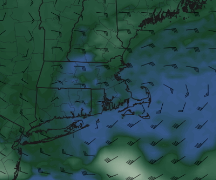
An example of what I and others posted earlier... 0z ICON last night showed this as well (but backed off at 12z today). This is from 12z UK, keeps low level easterly flow into 0z-6z Tuesday... this is what we'd need to get us closer to 20": (EDIT: this is 850, 0z Tuesday, from 12z UK run Jan 22):
-
This place is going to short circuit.
-
Several models are keying in on NE GA/NW SC as ground zero for freezing rain.
-

January 24-26: Miracle or Mirage JV/Banter Thread!
Interstate replied to SnowenOutThere's topic in Mid Atlantic
I am already two degrees warmer than my expect high today. There is no way it is going to snow on Saturday.


.thumb.JPG.418e8a9a2902ae687ec35ff4bc0e038e.JPG)
