csnavywx
-
Posts
5,546 -
Joined
-
Last visited
1 Follower

About csnavywx

Recent Profile Visitors
7,778 profile views


-
I'll raise you double. 2012 summers will be the norm by 2040 (maintaining CONUS trend) -- and I'd wager malaria deaths were a huge problem and co-morbidity with that heat in the South. AC no doubt was a big alleviant and enabled huge strides here and in other places (like Singapore), but swamp draining and mosquito/disease control were just as important on the death end (from 1880-1950). The ultimate limiter on outdoor activity in the future will be wet bulb temps and in terms of agricultural productivity (measured in total factor productivity) will be in absolute temps. Not much in the way of crops or tree cover survives a +8-10C anomaly summer. I wrote a big thread on this on X/Twitter recently. Some of it is reasoned speculation (and should be treated as such) and others are much more rooted in predictable trends. https://x.com/wxchris3/status/1941919707960926262 I know the hay that gets made over the 30s-50s and people like to really point at those -- but it's a bit rich to pretend like our agricultural practices didn't contribute to that and that we didn't vastly improve in both tech and wisdom from that point. The risk is that the underlying trend can and will undo that work.
-
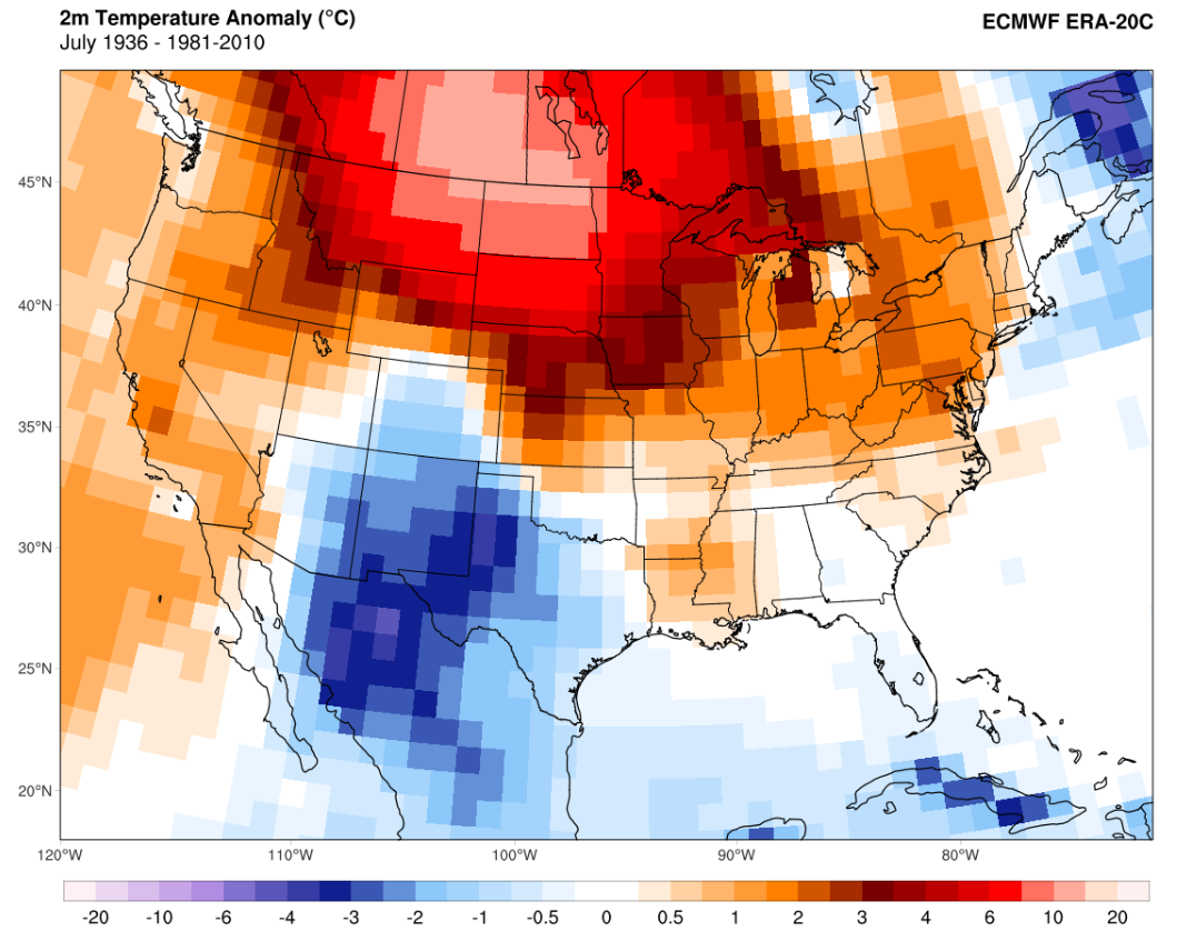
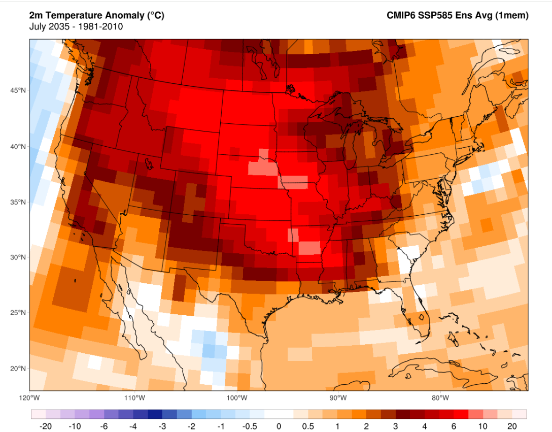
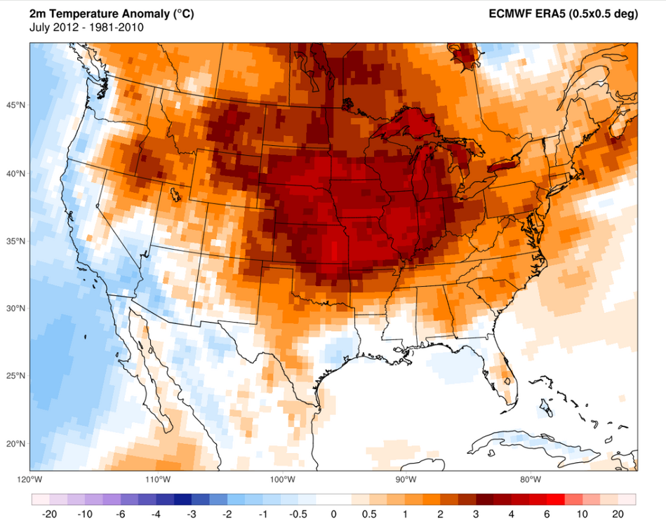
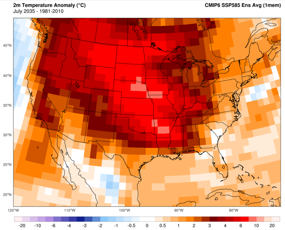
Yep. We're basically there now and the probability of it striking in any given summer has risen sharply. Going through SSP5 8.5 runs can give a feel for how bad it could get in 10-30y. For instance, it has summers occasionally far exceeding anything in the 1930s and 2012 by the *middle of next decade*. A few notes on that statement: While CO2 emissions are below 8.5 runs, radiative forcing and net energy imbalance is actually currently considerably *above* the 8.5 ensemble, mainly due to non-CO2 forcing being considerably above expectations -- and ECS/TCR might end up being on the hot side due to cloud feedback trends (detected by CERES). The most obvious brakes to this would be near term non-CO2 forcing slowdown, smoke aerosols (from extensive boreal burning -- seeing some of this already) and a weakening AMOC via differential hemispheric heating and a SMOC reversal (this too, may be in the early stages of happening). Regional trends are always a bear because transient climate responses can destructively or constructively interfere with the background trend and each other. A good example of this recently has been northern CONUS cooling in Feb-May due to a downstream response from rapid NPac cooling and cooling over the Corn Belt and adjacent areas from extensive evapotranspiration in Jun-Aug that has exchanged increased humidity for lower summer temps. These are transient responses -- and could and probably will unravel as the NHem temp response increases. Perhaps more importantly, one striking feature in future runs is the ever-present ability of intra-seasonal and intra-annual forcing to temporarily overwhelm and unravel those transient responses and result in an explosive, high volatility move that seems to come from nowhere and create conditions that seem to detach completely from the existing probability curve. The damping is removed and, like a coiled spring, the "true PDF" is revealed. These will tend to cause the most damage because of their inherent year-to-year unpredictability. A CMIP-6 run shows an example what that might look like (July 1936 and July 2012 are thrown in for good measure here): Far more extreme events in general start to occur as the NHem circulation is disrupted by the permanent collapse of summer sea ice in the late '30s-40s and by the time we hit 2050 we open up "lights out" events where temps and precipitation could destroy the existing plant stock and most of those year's crops. Events so intense and long that we could see our first "year without a winter".

-
Don't worry. Where we're going, the '30s-'50s dryland heat waves will look like a walk in the park. 2012 was the early warning shot. (Take the following as an example of *what could happen*):


-
Finally getting some cooling in the past couple of months after that record run for 2 years. CERES 12-month rolling average appears to have bottomed in Nov (March numbers are coming back up and it should recover more substantially when May numbers are out). Temp tends to lag this by quite a bit (up to a year) and cool ENSO could also help throw a lid on things through Q1/Q2 next year, but after that, we're free to start heading back up again barring (yet another) cool-neutral or Nina year. These next couple of years may see us slide under the 1.5 threshold (on all datasets) for the last time. I get the feeling we won't be seeing it again after the next spike, though.
-
Btw, I think the unusual convective behavior last night was in part due to the extreme (and highly stratified) Bay water temps imparting a lot of latent and sensible heat flux to the atmosphere when that back door cold front and aggregate outflow came in to help trigger it after sunset (along with some radiative cooling at the anvil level post sunset). Bay temps at 1.5m were running at 86-90F and probably quite a bit hotter in the top 1-2 ft. Storms did their job last night and temps are back down to 82-83F today.
-
The sensor is "in-spec". But it does tend to run 1-2 degrees warmer than it should and about a degree too soft on dewpoints. (This is with me various handhelds against the main ASOS sensor). But it's closer than I initially thought when I started to suspect it was too warm. It was at least 102-103 here on Wednesday. A few factors that helped: Evapotranspiration effects here tend to peter out faster than nearby stations because of lower tree cover and a lot of grass that tends to cure and brown quickly under very hot and dry conditions. That happened in just 3 days here this week. Note that during the peak temp, dewpoints dropped rapidly, indicating drier air from aloft mixing down as sensible heat flux increased relative to latent heat. There was no gradient flow and nearly perfectly barotropic conditions with a lot of subsidence and very strong vertical mixing. This prevented a sea breeze from properly forming on time and heavily stratified the surrounding waters. I was in that water in Pt. Lookout on Monday and the top layer was easily 10F+ warmer than 1-2m down. Lack of any appreciable mixing meant that the skin temp of the water surface was very hot and that helped disrupt/delay a sea breeze circulation in this locale.
-
Did ya'll enjoy your trip to Dubai yesterday? The pics of that dust wall gave me Persian Gulf flashbacks.
-
Got smoked here at Pax. Lotta 55+kt wind gusts (64kt/74mph peak) and 1/2" hail. Lasted about 10-15 minutes.
- 1,281 replies
-
- 5
-

-
- severe
- thunderstorms
- (and 2 more)
-
Nice supercell split to the NW of DC. There's an old outflow boundary (and a bay breeze!) to the east that could spell some trouble if those begin to interact with it.
- 1,281 replies
-
- 4
-

-
-
- severe
- thunderstorms
- (and 2 more)
-
On geologic timeframes, I agree we're in the last act. It's no longer even possible to get a snowball scenario now, insolation is already too high. The drawdown in GHGs over the last ~300-500Mya has mostly neatly offset the increase in insolation over time but that parameter space is now limited on the downside. I would venture a guess that current continental drift resulting in another supercontinent+2-3% insolation puts temps well above Eocene levels and ends the golden age of habitability. In either the short or long run, if you pancake the ETP temp gradient with either GHGs or insolation, you kill off most marine life during the transition. If it happens quickly enough, then you can end up with Canfield oceans -- which I would describe as a weird form of undeath (purple water and green atmosphere from euxinic conditions). In the very short run, we're extremely close (450ppm) to tipping over in the Southern Ocean with regards to ocean acidification causing widespread aragonite undersaturation, what I would consider the first step in that process.
-
Dangerous risk of termination shock and unexpected circulation changes. But I do think it will be done anyways.
-
Planck feedback/response stops any sort of Venusian runaway on this planet. Would take much higher insolation to get us there. Much more worried about plant and/or soil carbon stock turning unstable at current temperatures. It's been showing signs the last few years, esp with large emissions from respiration. South America and southern Africa in particular do not seem to be taking it well. Some of this is probably due to monsoon trough migration via differential hemispheric heating and boosted non-CO2 warming recently from aerosols and higher-than-trend CH4, causing a lopsided NH response. But if the Amazon and southern African tropical sinks can no longer provide a brake, then that will cause an immediate and relatively strong increase in the airborne fraction.
-
Isn't there a pretty well documented increase in C/EPac trade winds over the last 40+y? I'd think that (plus the aerosol pattern effect) would have a pretty drastic effect on SST patterns and the downstream Pac climate indices. Also probably can't get away from the insane post-2020 NPac/NAtl warming (N Hem in general) and the effect it's already having on the position of the ITCZ/monsoon trough via response to differential warming.
-
Actually really like this setup for some semi-discrete or discrete cellular activity (as shown by the NAM). While the best forcing goes north with the surface low and south with some trailing mid-level forcing and better cape, there is still some forcing for vertical motion here and some weak capping with halfway decent CAPE. Could be just enough to suppress crapvection and allow for more discrete activity to thrive, esp towards/just after sunset.
- 1,281 replies
-
- 3
-
-
- severe
- thunderstorms
- (and 2 more)
-
TRACC/CMIP-6 is already behind the curve: On full blast from here with Med shipping sulfur emission controls taking effect this year.