All Activity
- Past hour
-

2026-2027 Super El Nino
Maestrobjwa replied to Stormchaserchuck1's topic in Weather Forecasting and Discussion
It literally has been--and it happens to be every other one too: 65-66 yes, 72-73 no, 82-83 yes, 97-98 no, 15-16 yes...so are we about to be no again according to that pattern? Lol -

2026-2027 Super El Nino
GaWx replied to Stormchaserchuck1's topic in Weather Forecasting and Discussion
“Snowy” in ATL can be ~3”+ as the average SN/IP is ~2”. Thus snowy in ATL can easily be from just one storm. More often than not, “snowy” in any particular location in the SE US away from the mountains is mainly from just one major storm along with possibly one+ minor hits. Another thing about a place like ATL or even RDU vs Marquette: a much larger % of the wintry precip is sleet or ZR when averaged out over the decades. I roughly estimate 1” of sleet is equivalent to 2.5” of snow on average. So, for example, ATL got ~4” of sleet in 2/1979 and 1/1988. They had the water equivalent, impact, and staying power of ~10” of snow. In addition, ZR doesn’t even measure as S/IP as we know. So, the 2” ATL avg tends to understate to an extent its avg wintry precip vs, say, a straight 2” avg snow. -
There's a chance for another head fake then?
-
Nice change for them following the warmest July 1st through 4th. Time Series Summary for WESTCHESTER CO AP, NY Warmest July 1st through 4th Click column heading to sort ascending, click again to sort descending. 1 2026-07-04 84.5 0 2 1966-07-04 82.1 0 3 2002-07-04 81.6 0 4 2018-07-04 81.3 0 - 1964-07-04 81.3 0 5 1955-07-04 80.4 0
-
Svr wx possible around the Northland tonight. But there is a cap in play, so we'll see what can break that.
-

2026-2027 Super El Nino
LakePaste25 replied to Stormchaserchuck1's topic in Weather Forecasting and Discussion
I’d put the mid atlantic under “equal chances” IMO. Super Ninos are usually hit or miss there, dependent on 1 storm. It’s close to 50% likelihood given the sample size. -
My grass is growing like it would in Vietnam at this point
-
 buying prescription drugs in mexico: MedSelect Mexico - overseas online pharmacy
 -
July 26 1981: A chilly morning occurs across the Northland, with 33 degrees at Roseau and Wannaska. For Sunday, July 26, 2026 1819 - Twin cloudbursts of fifteen inches struck almost simultaneously at Catskill, NY, and Westfield, MA. Flash flooding resulted in enormous erosion. (David Ludlum) 1943 - Tishomingo, OK, baked in the heat as the mercury soared to 121 degrees, a state record. (The Weather Channel) 1960 - The temperature at Salt Lake City, UT, hit 107 degrees, an all-time record high for that location. (The Weather Channel) 1987 - Thunderstorms developing along a cold front produced hail two inches in diameter in McHenry County, IL, and wind gusts to 70 mph at Auburn, ME. A wind gust of 90 mph was recorded at Blairstown, NJ, before the anemometer broke. The high winds were associated with a small tornado. The record high of 88 degrees at Beckley, WV, was their sixth in a row. (The National Weather Summary) (Storm Data) 1988 - Thunderstorms produced large hail and damaging winds in the Middle Atlantic Coast Region, and in the south central U.S. Eight cities in the northwestern and north central U.S. reported record high temperatures for the date. Salem, OR, hit 103 degrees. (The National Weather Summary) 1989 - Morning thunderstorms produced heavy rain in southeastern Texas, with more than three inches reported at the Widllife Refuge in southwestern Chambers County. Evening thunderstorms produced severe weather in Montana, with wind gusts to 62 mph reported at Helena. Eight cities from Maine to Minnesota reported record high temperatures for the date, including Newark, NJ, with a reading of 99 degrees. (The National Weather Summary) (Storm Data) Observances: 26 Sun Uncle and Aunt Day 26 Sun Parents' Day 26 Sun National Disability Independence Day 26 Sun Auntie's Day 26 Sun Holistic Therapy Day 26 Sun National All or Nothing Day 26 Sun National Bagelfest Day 26 Sun National Coffee Milkshake Day 26 Sun National Saint Day 26 Sun One Voice Day 26 Sun World Mangrove Day 26 Sun World Tofu Day 26 Sun National Aunt and Uncle Day
-
RGEM too-although more localized.
-
Cloudy morning. Suppose to be sunny today with stms tonight. Heat adv out. DLH is under Heat warning. Yesterday was 80 with a 70 dew. Muggy, but comfortable. We'll see if it warms more today. Point has 82.
-
 ...while methuen ends up .25.....
 -
1.04'' this morning. Up to 12.34'' for the month.
-

2026-2027 Super El Nino
michsnowfreak replied to Stormchaserchuck1's topic in Weather Forecasting and Discussion
Just a suggestion if you guys make future snow maps closer to winter. It usually helps if you give a rough % of average to go in line with your thinking. I knew what raindance was getting at with the snow map (admittedly just a preliminary joke map rough idea) but it always looks funny when you see something like "snowy" in Atlanta and "not snowy" in Marquette. -
 do you want to fuck her like every other climate change denier
 -

2026 Mid-Atlantic Severe Storm General Discussion
high risk replied to Kmlwx's topic in Mid Atlantic
I'd usually agree with you. But as we now move into CAM range, recognizing that the U.S. CAMs all have some influence of the GFS, the solutions seem to be favoring the GFS more. The idea of a deep sfc low over the St Lawrence Valley isn't dead in the Euro, but even its AI version likes a secondary low in the Mid-Atlantic. Verbatim, some pretty strong forcing rolls through during the morning and midday hours, which screams flash flooding more than severe. That said, 1) a surface low will be nearby, so you always need to watch for a tornado threat, especially if we can heat up before the forcing arrives 2) there is time to change some of the synoptic details- 1,477 replies
-
- 1
-

-
- severe
- thunderstorms
- (and 7 more)
-

2026-2027 Super El Nino
40/70 Benchmark replied to Stormchaserchuck1's topic in Weather Forecasting and Discussion
If I had a snowfall map right now, it would look like raindance's. - Today
-
2026-2027 Super El Nino
40/70 Benchmark replied to Stormchaserchuck1's topic in Weather Forecasting and Discussion
I could not agree with raindance more....my QBO composite is a bit different, but he just echoed that premise of my write up last night with absolute surgical precision in just a far more condensed manner. Here an excerpt from my work: Key Factors to Potentially Fuel More Active Second Half than Currently Forecast The preliminary Eastern Mass Weather polar composite is littered with seasons that underwent a notable transition from a benign December-January period to a rather frenzied February and/or March, as El Niño peaks and undergoes a subtle change in orientation. It was mentioned that this is a signal that is emergent among some seasonal guidance. It was postulated that these forecasts are overstated and exaggerated, and are likely to be transient in nature. However, it was also asserted that the forecast unprecedented intensity of El Niño should be of sufficient magnitude to at long last shift the western Pacific warm pool, which has been a fixture for a over a decade, further to the east. The question is whether it simply shifts to the dateline and acts as a Modoki, or even further east, which would heighten the odds of a very mild outcome, per the intense/east-based El Niño composites. Another option is for it to not move enough, which may produce an outcome similar to the MC-oriented 2023-2024 season, which is viewed was the least likely outcome. At the very least, the European seasonal guidance is supporting the current forecast for a mid season transition to greater volatility, but it looks to be even more exaggerated given it's assessment of the January polar domain. Perhaps the eruption of Mount Agung was not justification for the outright dismissal of the 1963-1964 QBO analog from the polar composite, however, there is plenty of time to assess that decision as subsequent trends are modeled and future data is digested. -
Enhanced for wi
-
I’m not yet convinced we’ve turned the corner on the long term drought and that giga-Nino is kicking in precip-wise…but the evidence is building. I’ll have to see what august looks like. I’m feeling pretty sure that by mid/late September we’ll have turned the corner for good. At least until our next multi year Nina which starts next fall lol
-
 Our lifetimes at least.
 -
Interesting
-
It’s not on the books but that doesn’t mean it won’t happen.
-
Lol the nam went berserk. 6 to 10" of rain
-
(002).thumb.png.6e3d9d46bca5fe41aab7a74871dd8af8.png)
Central PA Summer 2026 Discussion/Obs Thread
ChescoWx replied to Voyager's topic in Upstate New York/Pennsylvania
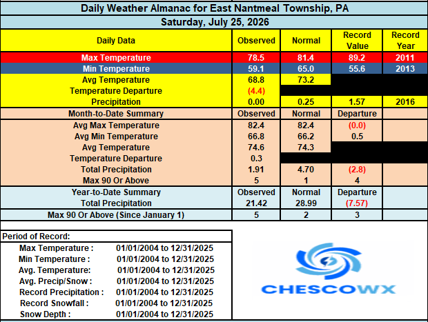
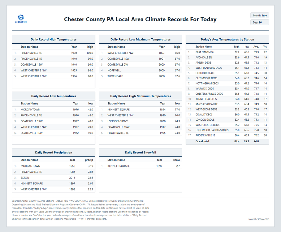
One last great weather day before we turned unsettled and wet for a good part of the upcoming work week. Hopefully, most of us see some rain as many spots, especially across Northern Chester County missed the rains last week. Below normal temperatures look to continue all week but with increasing humidity with the rain. The sun looks to it will return by Friday. Note: below on the climate records there is an errant snow report in the data set that is being corrected.