All Activity
- Past hour
-
This one has a debris ball on the Hytop (NWS Huntsville) radar. Tornado Warning Severe Weather Statement National Weather Service Huntsville AL 710 PM CDT Tue May 20 2025 ALC071-089-210030- /O.CON.KHUN.TO.W.0044.000000T0000Z-250521T0030Z/ Jackson AL-Madison AL- 710 PM CDT Tue May 20 2025 ...A TORNADO WARNING REMAINS IN EFFECT UNTIL 730 PM CDT FOR NORTHWESTERN JACKSON AND NORTHEASTERN MADISON COUNTIES... At 709 PM CDT, a confirmed tornado was located near New Market, or 7 miles east of Moores Mill, moving east at 30 mph. Debris signiture seen north of Gurley. HAZARD...Damaging tornado and two inch hail. SOURCE...Radar confirmed tornado. IMPACT...Flying debris will be dangerous to those caught without shelter. Mobile homes will be damaged or destroyed. Damage to roofs, windows, and vehicles will occur. Tree damage is likely. Locations impacted include... Maysville, Skyline, Princeton, Estillfork, Brownsboro, Larkin, Gurley, Pleasant Groves, Trenton, and Garth. PRECAUTIONARY/PREPAREDNESS ACTIONS... To repeat, a tornado is on the ground. TAKE COVER NOW! Move to a basement or an interior room on the lowest floor of a sturdy building. Avoid windows. If you are outdoors, in a mobile home, or in a vehicle, move to the closest substantial shelter and protect yourself from flying debris. && LAT...LON 3468 8653 3489 8648 3499 8617 3473 8609 TIME...MOT...LOC 0009Z 254DEG 26KT 3482 8639 TORNADO...OBSERVED MAX HAIL SIZE...2.00 IN $$ GH
-
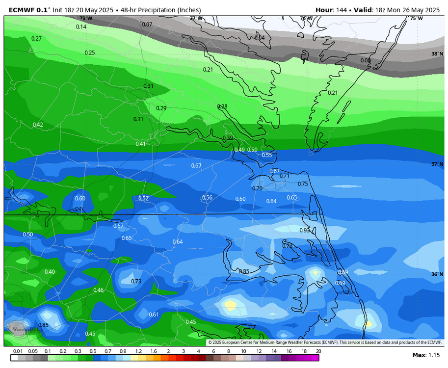
WB 18Z EURO...iffy beach weekend Sunday/Monday period, but still early.
-

2025-2026 ENSO
Stormchaserchuck1 replied to 40/70 Benchmark's topic in Weather Forecasting and Discussion
AAO correlation worked out last year - It was a very negative Aug/Sept AAO, and that rolled forward to a pretty strong signal on a cold December/January, -AO, North Pole was +0.5 correlation rolled forward. AAO has been very positive March - May, all but like 5 days positive. How that rolls forward to the following N. Hemisphere Winter +9 months is a lot of time, but it's an ok signal. This is what I would think +AAO would look like down the line (slight correlation with AO/EPO) -
Did NWS Nashville lose power or shelter? All of their warnings and updates are coming from NWS Fort Worth the past 20 minutes
-
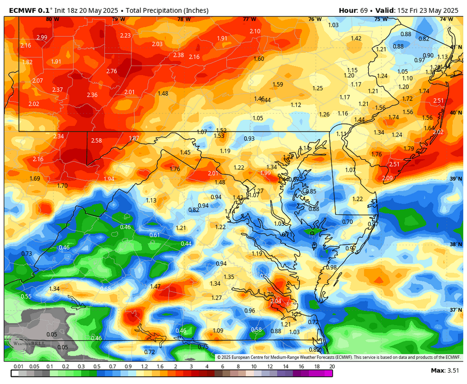
WB 18Z EURO for midweek.
-
18Z GFS does as well
- Yesterday
-
I'd actually be surprised If it doesn't happen.
-
18z NAM is cold Thursday night.. flakes for some
-

2024-2025 La Nina
ChalkHillSnowNut replied to George001's topic in Weather Forecasting and Discussion
I saw an article saying Antarctic ice grew the last year for the first time in a decade- -
Hopefully our north Alabama and Nooga area folks are ready to shelter.
-
Tornado Warning Tornado Warning ALC071-089-210030- /O.NEW.KHUN.TO.W.0044.250520T2344Z-250521T0030Z/ BULLETIN - EAS ACTIVATION REQUESTED Tornado Warning National Weather Service Huntsville AL 644 PM CDT Tue May 20 2025 The National Weather Service in Huntsville Alabama has issued a * Tornado Warning for... Northwestern Jackson County in northeastern Alabama... Central Madison County in north central Alabama... * Until 730 PM CDT. * At 644 PM CDT, a confirmed large and extremely dangerous tornado was located over University Of Alabama In Huntsville, or near Huntsville, moving east at 30 mph. This is a PARTICULARLY DANGEROUS SITUATION. TAKE COVER NOW! HAZARD...Damaging tornado. SOURCE...Emergency management confirmed tornado. IMPACT...You are in a life-threatening situation. Flying debris may be deadly to those caught without shelter. Mobile homes will be destroyed. Considerable damage to homes, businesses, and vehicles is likely and complete destruction is possible. * The tornado will be near... Alabama A And M University, Moores Mill, and Huntsville around 650 PM CDT. Other locations impacted by this tornadic thunderstorm include Maysville, Princeton, Estillfork, Pleasant Groves, Trenton, Garth, Ryland, Hollytree, Brownsboro, and Larkin. PRECAUTIONARY/PREPAREDNESS ACTIONS... To repeat, a large, extremely dangerous and potentially deadly tornado is on the ground. To protect your life, TAKE COVER NOW! Move to a basement or an interior room on the lowest floor of a sturdy building. Avoid windows. If you are outdoors, in a mobile home, or in a vehicle, move to the closest substantial shelter and protect yourself from flying debris. && LAT...LON 3465 8668 3482 8674 3499 8617 3473 8609 TIME...MOT...LOC 2344Z 254DEG 26KT 3476 8663 TORNADO...OBSERVED TORNADO DAMAGE THREAT...CONSIDERABLE MAX HAIL SIZE...2.00 IN $$ KTW
-
It would be interesting to see what kind of summers we generally have after a cool May. May is close enough to summer to serve as some gage I take it?
-
There is a large tornado on the ground in Madison County, AL near Madison right now headed towards the northside of Huntsville Tornado Warning 5/20/2025 19:24 EDT through 5/20/2025 19:45 EDT Tornado Warning issued May 20 at 6:24PM CDT until May 20 at 6:45PM CDT by NWS Huntsville AL ...A TORNADO WARNING REMAINS IN EFFECT UNTIL 645 PM CDT FOR SOUTHWESTERN MADISON AND SOUTHEASTERN LIMESTONE COUNTIES... At 622 PM CDT, a confirmed large and destructive tornado was located near Madison, moving east at 35 mph. TORNADO EMERGENCY FOR WESTERN MADISON AND EASTERN LIMESTONE COUNTY. This is a PARTICULARLY DANGEROUS SITUATION. TAKE COVER NOW! HAZARD...Deadly tornado. SOURCE...Radar confirmed tornado. IMPACT...You are in a life-threatening situation. Flying debris may be deadly to those caught without shelter. Mobile homes will be destroyed. Considerable damage to homes, businesses, and vehicles is likely and complete destruction is possible. The tornado will be near... Madison and Huntsville around 630 PM CDT. University Of Alabama In Huntsville and Redstone Arsenal around 635 PM CDT. Alabama A And M University around 645 PM CDT. Other locations impacted by this tornadic thunderstorm include Belle Mina, French Mill, Mooresville, Capshaw, Ryland, Hampton Cove, Ripley, Brownsboro, and Farley. Instructions To repeat, a large, extremely dangerous, and potentially deadly tornado is on the ground. To protect your life, TAKE COVER NOW! Move to an interior room on the lowest floor of a sturdy building. Avoid windows. If in a mobile home, a vehicle or outdoors, move to the closest substantial shelter and protect yourself from flying debris.
-
An extended period of cool weather is now underway. This morning, the temperature slipped to 49° in Central Park. That was New York City's coolest temperature this month. The below normal temperatures could persist into early next week. A general 0.50"-1.50" rainfall is likely tomorrow into Thursday. A gusty wind will likely accompany the rainfall. Showers could persist into Friday. There is a chance that New York City could see the mercury dip below 50° Thursday or Friday. The ENSO Region 1+2 anomaly was 0.0°C and the Region 3.4 anomaly was +0.1°C for the week centered around May 7. For the past six weeks, the ENSO Region 1+2 anomaly has averaged +0.55°C and the ENSO Region 3.4 anomaly has averaged -0.07°C. Neutral ENSO conditions will likely continue through at least mid summer. Early indications are that summer 2025 will be warmer than normal in the New York City and Philadelphia areas. The potential exists for a much warmer than normal summer (more than 1° above normal). The SOI was +0.09 today. The preliminary Arctic Oscillation (AO) was -0.511 today. Based on sensitivity analysis applied to the latest guidance, there is an implied near 53% probability that New York City will have a cooler than normal May (1991-2020 normal). May will likely finish with a mean temperature near 63.1° (0.1° below normal).
-
We definitely busted high today, I was hot working outside moving stone. Usually it seems like we're lower than advertised though, we're at 3k ft elevation on the nose.
-
With the best intentions, two arms make all the difference. As always ….

-
Just imagine... One minute you're doom scrolling your way down the road and then next thing you know not only do you need at bare minimum a new windshield but a camera crew is there recording your ass. Still beats dying ig
-
It hasn’t looked very impressive since it got into the mesos range.
-

2025 Short Range Severe Weather Discussion
mob1 replied to Chicago Storm's topic in Lakes/Ohio Valley
Bismarck IL looks to have taken a hit from a confirmed tornado. -

2025 Spring/Summer Mountain Thread
Met1985 replied to Maggie Valley Steve's topic in Southeastern States
Tornado watch will be hoisted up this evening for WNC per Jason Boyer. -
The incoming system is affected by blocking HP over E. Canada, but it is riding a little too far north for a soaking rain.
-
1.90" since yesterday. We definitely needed it.
-
My latest freeze is May 31st (1984), so there is always a chance......
-
Just wait for that downsloping blowtorch in another month or so. Back to desert for you.