All Activity
- Past hour
-
No choice in the matter.
-
Dont need it, dont want it Sent from my SM-S921U using Tapatalk
-
Afternoon AFD from LWX Any low clouds or fog should burn off quickly tomorrow morning. Much warmer air will advect into the area tomorrow in southwesterly flow aloft, with 850 hPa temperatures surging to around 14-17 C. Strong daytime heating will lead to deep mixing, enabling temperatures to near record values for late March. Most of the forecast area should climb into the 80s, with some locations potentially even making it into the mid-upper 80s. A strong cold front will start to progress southward across PA during the afternoon hours tomorrow. Showers and storms are expected to develop along the front during the mid-late afternoon hours. Further south, model soundings show signs of capping with a remnant elevated mixed layer moving in aloft. This should help to prevent the development of storms ahead of the front, which will keep conditions dry through nearly all of the day in our forecast area. The storms over PA will likely drift southeastward toward northern Maryland around or shortly after dark. As low- levels stabilize with loss of daytime heating, the trend should be for these storms to gradually weaken as they move into our forecast area after dark. The environment to our north tomorrow across PA looks very favorable for the development of severe thunderstorms, with a CAPE/shear parameter space capable of producing both supercells and bowing segments. If the timing/location of the front were to trend faster/further south, we could get storms in that type of environment prior to stabilization. And even if storms do move in after dark, they could still potentially produce severe hail, even if they`re elevated. Tomorrow is certainly a day to watch for severe thunderstorms, but as it stands now, it may be a near miss for most of the area, with the capping serving as a potential saving grace. As of now, SPC has northern Maryland and most of the eastern panhandle of West Virginia outlooked in a Slight Risk, and the rest of the area outlooked in a Marginal Risk. SPC also has far northwestern portions of the forecast in a sig hail outlook (indicating the potential for 2+" hailstones). That hints at the potential high ceiling for the severity of storms tomorrow, if they maintain their strength southward into our forecast area. As of now, the most likely timing for storms looks to be between 7 PM and Midnight, with remnant showers moving southward along with the cold front through the entire forecast area later during the overnight hours. Winds will shift to out of the northwest behind the cold front on Monday. Conditions will dry out and temperatures will be much cooler (but near normal), with highs for most in the 50s and lower 60s (40s mountains). Winds will gust to around 25-35 mph out of the northwest
-
Chem trails Sent from my SM-S921U using Tapatalk
-
Huh. March hasn’t been that warm all things considered and even DCA had a freeze this week. 2015 did have a cold March though.
-
seasons in seasons

-
Cedar Rapids is up to 83º at 2pm. Des Moines is 89º.
-
My son lives in Bozeman, says people don’t know what’s going on. No winter.
-

Pittsburgh/Western PA WINTER ‘25/‘26
TheClimateChanger replied to Burghblizz's topic in Upstate New York/Pennsylvania
-
The stuff in my yard is late, but curiously the cherry blossoms at the Tidal Basin are only slightly behind normal. Extension of Florets was March 16. In 2015 it was Apr 4!
-
.thumb.jpg.6a4895b2a43f87359e4e7d04a6fa0d14.jpg)
Central PA Spring 2026 Discussion/Obs Thread
Yardstickgozinya replied to Voyager's topic in Upstate New York/Pennsylvania
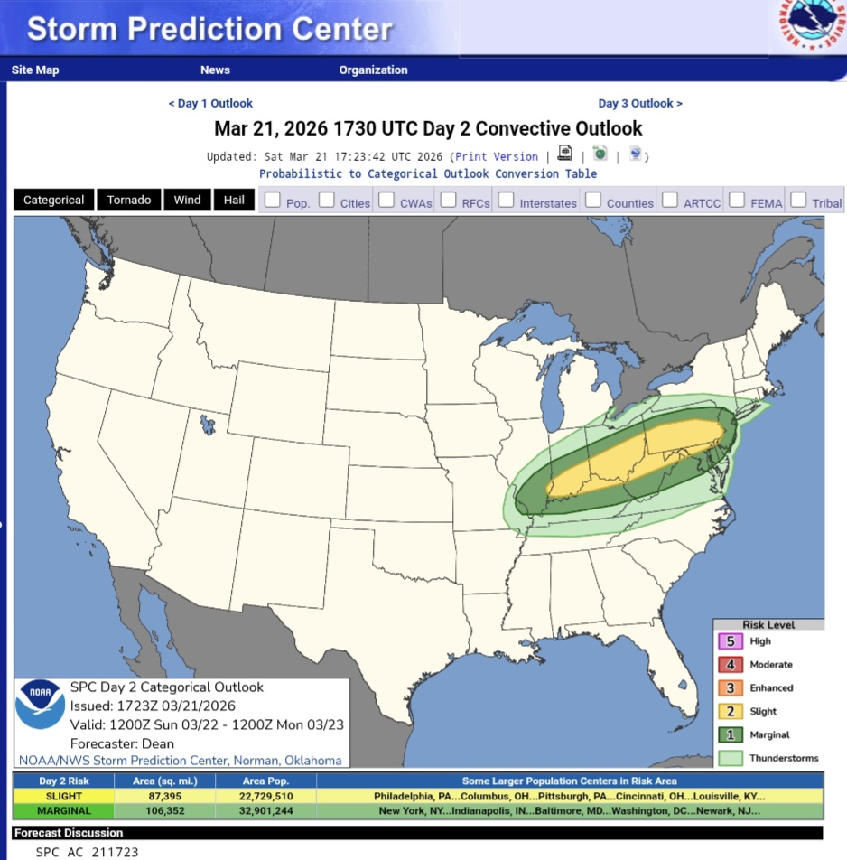
Basically expanded to include most of the state. From what I gather, severe storms will be quite isolated , but carry the risk of large hail up to the size of golf balls. Spc added that they may need to add a elevated tornado risk to the outlook. Main bust threat is lack of moisture return. Thunderstorms are expected to expand in coverage for the late afternoon and evening but are expected to be more elevated at that point. https://www.spc.noaa.gov/products/outlook/day2otlk.html
-

2026-2027 El Nino
A-L-E-K replied to Stormchaserchuck1's topic in Weather Forecasting and Discussion
Another super? Cool -

E PA/NJ/DE Spring 2026 Obs/Discussion
MGorse replied to PhiEaglesfan712's topic in Philadelphia Region
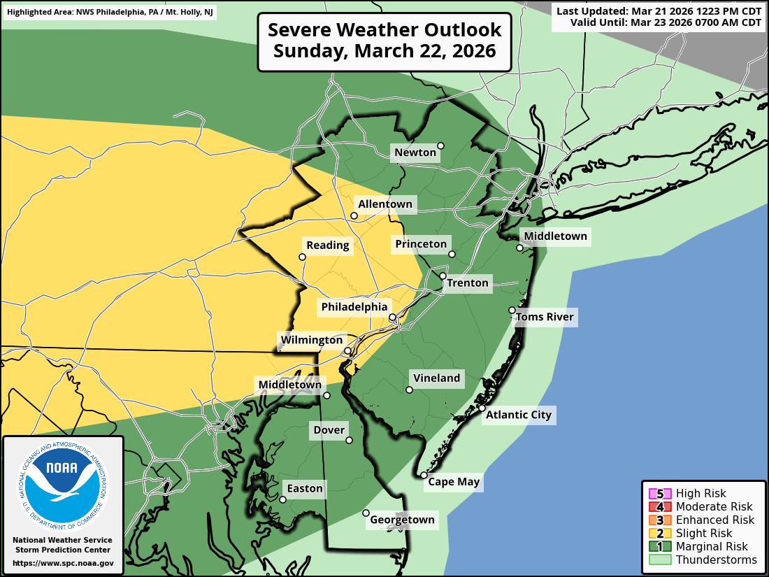
SPC outlook for tomorrow.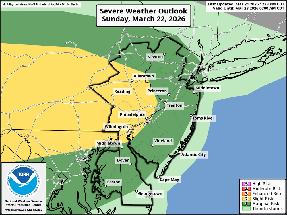
-

Pittsburgh/Western PA WINTER ‘25/‘26
Rd9108 replied to Burghblizz's topic in Upstate New York/Pennsylvania
Appears we have a chance at hail tomorrow with a strong signal for developing supercells. -
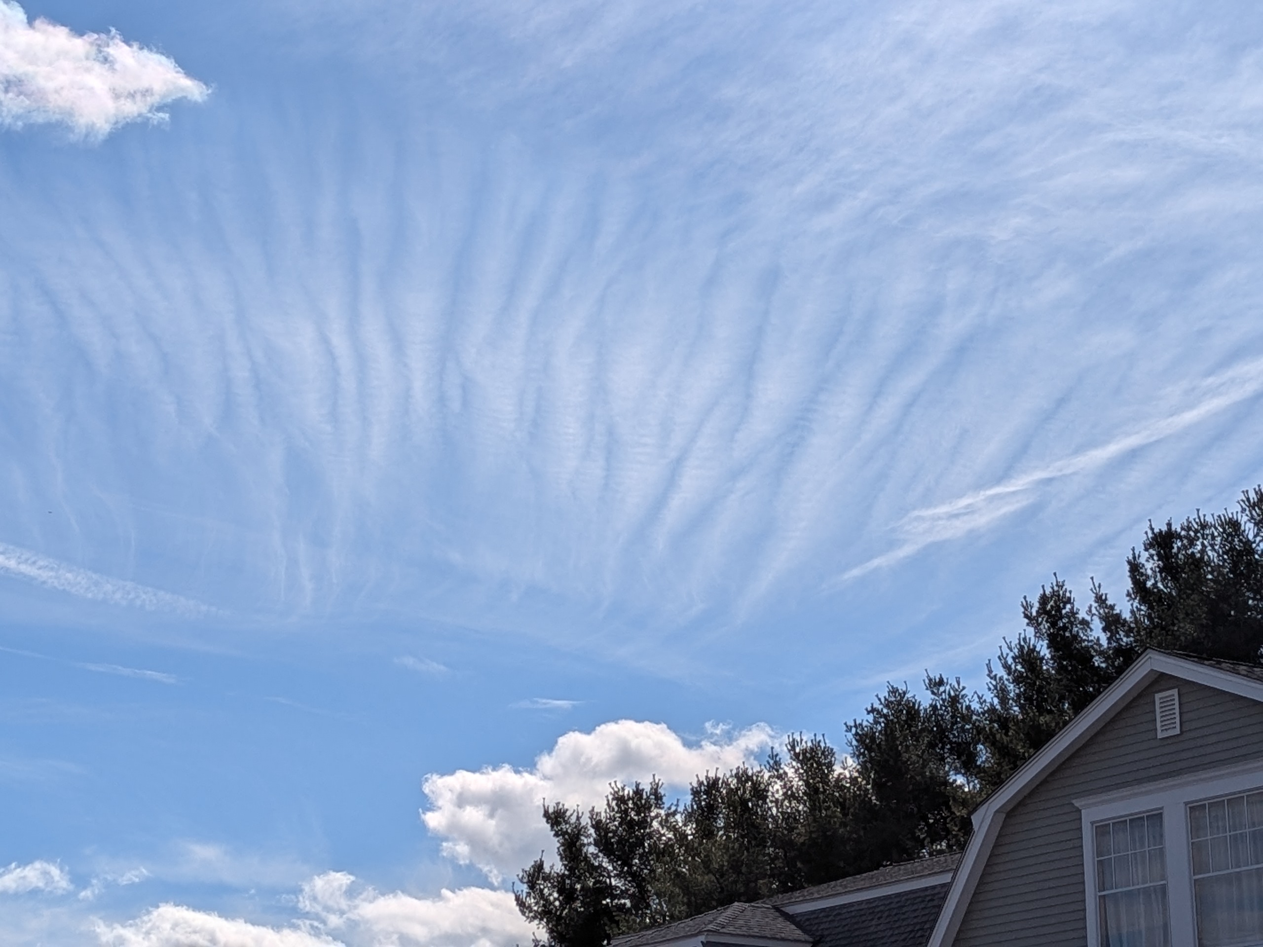
Looks to be a bit of gravity wave action over CT this afternoon...

-
I-80 was closed during the blizzard over much of Iowa, and a good portion of that stretch will exceed 90 5 days later.
-
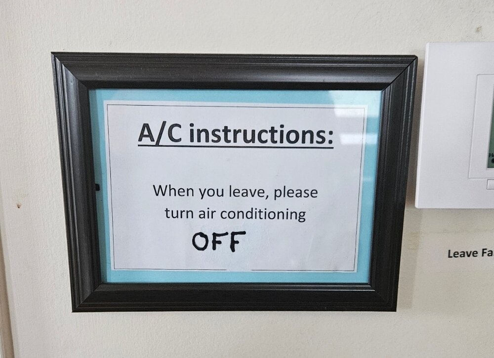
I saw these signs at a meeting i was at in rural Virginia yesterday and they made me smile...the simple life still exists

- Today
-
Hoisted
-
It looks like the forecast high in the low 60s here comes just before dark. Meh.
-
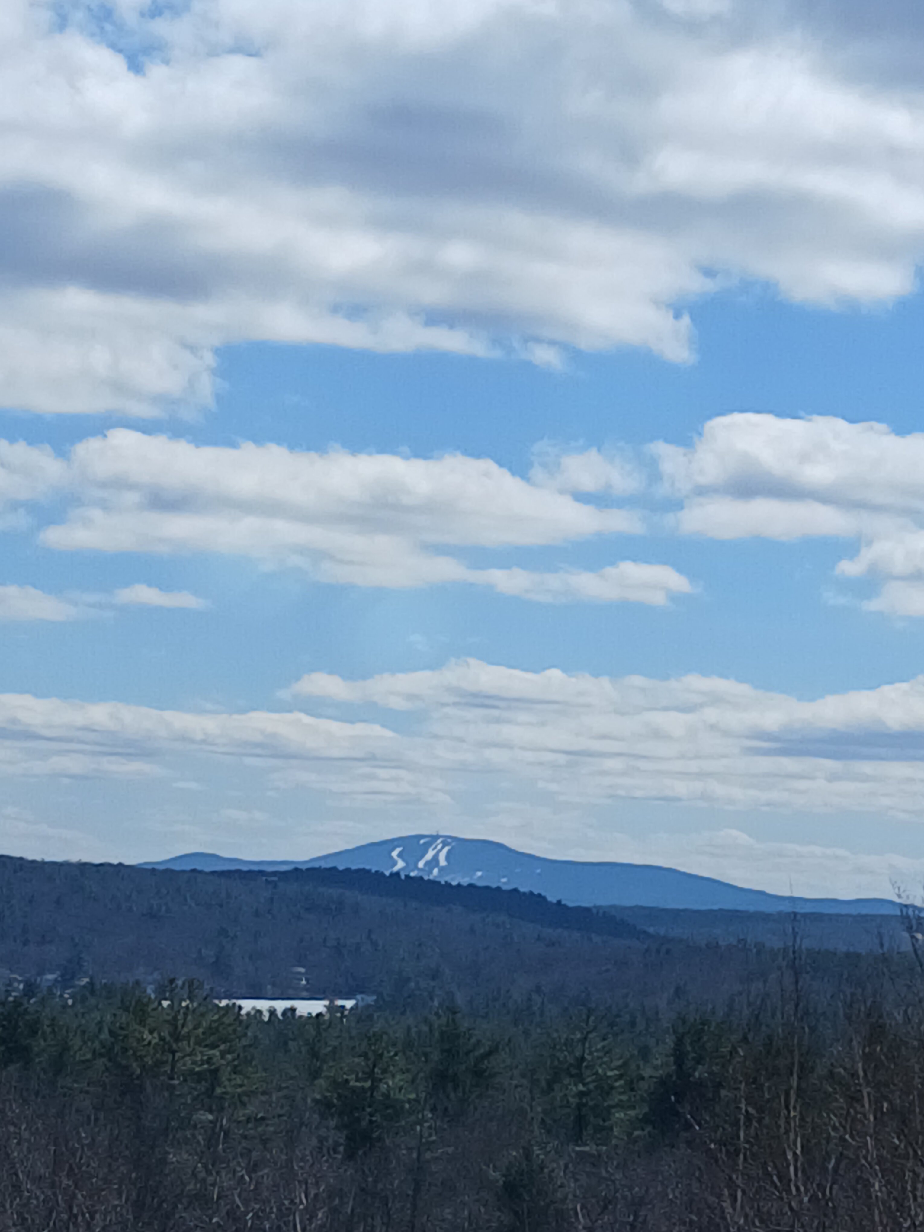
I was there (WaWa) earlier today. Zero lines. Still plenty of trails open (but definitely fading)
-
Some signs we get clipped with a little snow tomorrow even down here...better change Monday. Just need .25" to get to 80 on the season.
-
At the mother in laws picture perfect day

-
That would be bad here in March. No way we don’t freeze hard after. By early May I’ll take it.
-

Central PA Spring 2026 Discussion/Obs Thread
Jns2183 replied to Voyager's topic in Upstate New York/Pennsylvania
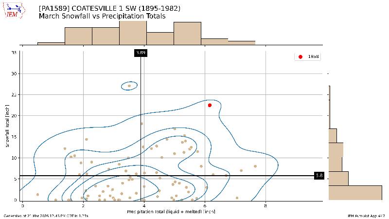
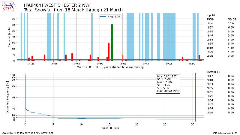
I thought you might enjoy these graphs Sent from my SM-S731U using Tapatalk.jpg.6d4baada70941c5e9d3cdd456d132989.jpg)
-
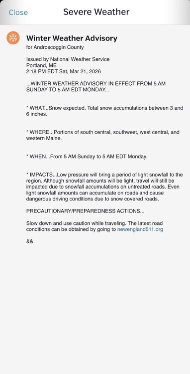
I will soon, Usually April, Already cancelled my weathermodels one.