
All Activity
- Past hour
-

E PA/NJ/DE Summer 2026 Obs/Discussion
BBasile replied to PhiEaglesfan712's topic in Philadelphia Region
Currently 91F with a 76F dew.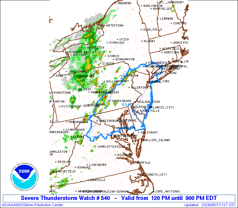
-
no grahics or discussion yet
-
-
And they issued a watch bigger than the slight risk area
-
.thumb.gif.f92b16c631a1d15d405ed77b33f0710d.gif)
Augdewst 2026: Summer's Last Stand
Torch Tiger replied to Prismshine Productions's topic in New England
6/20/95 was nasty in E MA/RI too. nothing high-end, but widespread borderline severe -
the whole area is under a watch got an alert like 10 minutes ago except for Long Island.
-
it is so nice out
-
no watch here yet - BUT they are experiencing severe weather in Central PA with a line developing and a watch was never issued for them
-

Augdewst 2026: Summer's Last Stand
CoastalWx replied to Prismshine Productions's topic in New England
We had some bigguns in Brockton. 104mph macroburst May 96, July 99 with baseball hail and wind. -

2026 Mid-Atlantic Severe Storm General Discussion
George BM replied to Kmlwx's topic in Mid Atlantic
Severe Thunderstorm Watch out until 9pm. -
I think Greta is the center fold this year.
-
-
what, no railing on that side? that's not up to code!!
-
Augdewst 2026: Summer's Last Stand
DavisStraight replied to Prismshine Productions's topic in New England
There was one storm back in the 90s or early 2000s, forget which that went through Middlesex County Mass, I lost count of how many houses I went to that had new roofs because of the hail in the storm. -

2026-2027 Record-breaking El Nino
mitchnick replied to Stormchaserchuck1's topic in Weather Forecasting and Discussion
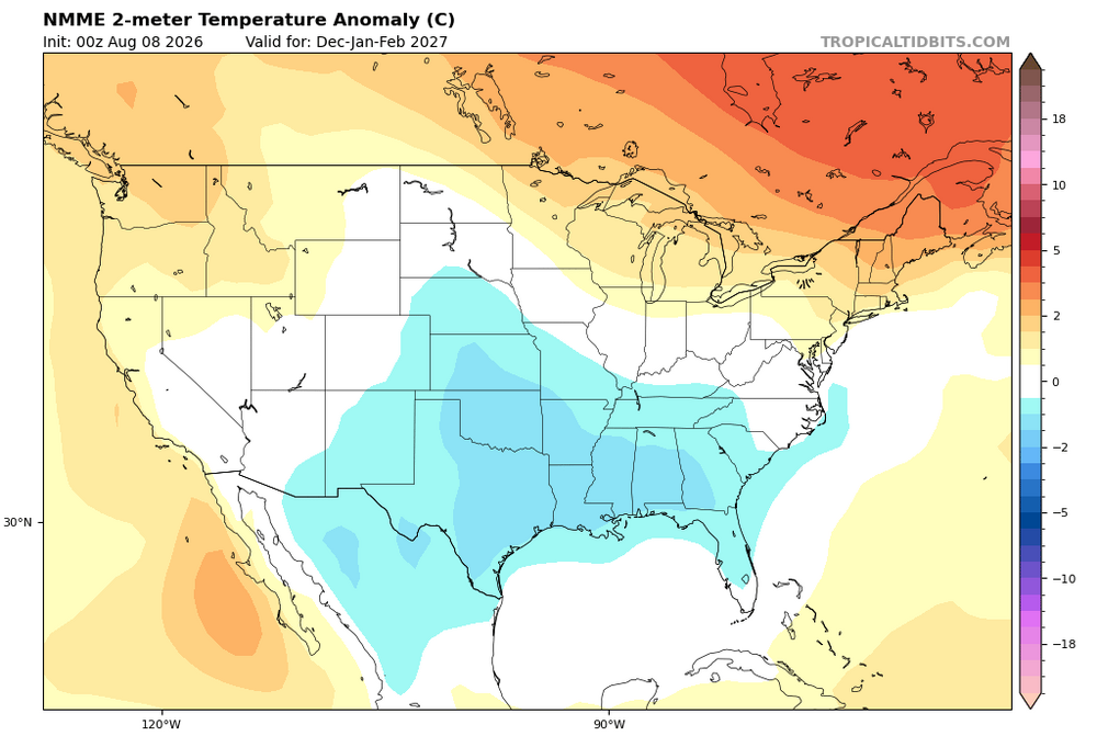
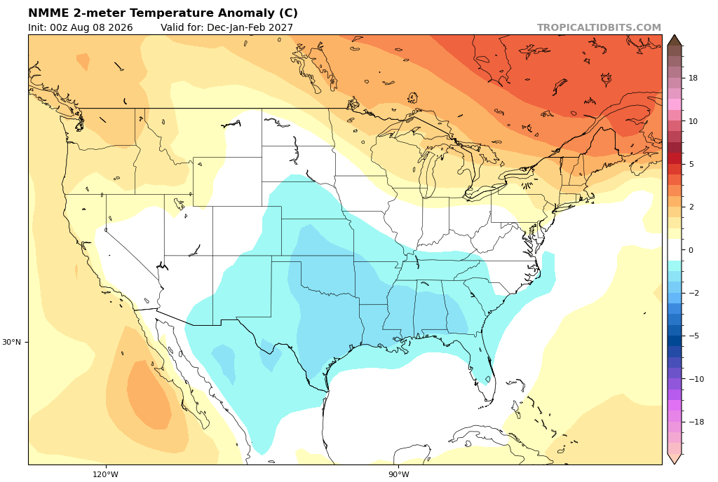
Updated NMME hasn't caved on the generally cooler look with this month's run vs last like the Euro. Top 2 pics are DJF temps from last month and today. Bottom 2 are JFM same comparison. P.s. Note I said "generally." Some spots up to the NE not. Also, wet along the east coast and inland some. https://www.tropicaltidbits.com/analysis/models/?model=nmme®ion=us&pkg=apcpna_multimonth_nmme&runtime=2026080800&fh=6.thumb.png.e585058f6af0d126731e6b8d3af8987c.png)
.thumb.png.2797edbe752d95780a3f989866c21740.png)
.thumb.png.52606a2921a2116c80020eed36c46dcf.png)
-
@donsutherland1@bluewave I noted previously some concerns about data discontinuity in the ASOS stations since the switch from the legacy HO-1088 to the new HMP155E and the new RM Young 43502 shelters. Of particular note, the ventilation/aspiration rate has been increased from 4-10x (from ~1 m/s to 5-11 m/s). To date, I'm unaware of any published NOAA/NWS comparative studies on the change. In the past, all of these changes were published and documented. So, to get a better idea at the magnitude of the potential bias, I looked at 75 cooperative stations reporting in Pennsylvania for both 2022 & 2026 (excluding Altoona 3 W, which had only 1 day of data last month) and 58 cooperative stations in Ohio reporting for both 2022 & 2026. And compared this to 26 WBAN (generally ASOS) stations in Pennsylvania and 28 WBAN stations [including CVG] in Ohio, and boy the differences are night & day. Across the Pennsylvania coop network, 2026 was 0.2F warmer than 2022, with max temperatures .55F cooler and minima 0.91F warmer. Across the WBAN stations, 2026 was -0.92F cooler, with daytime maxima 1.44F cooler & overnight lows about -.4F cooler. Same story in Ohio. The cooperative stations were ~1.2F warmer in the means, while the WBAN sites averaged about 0.1F cooler. Overall, Pennsylvania cooperative stations averaged 1.12F warmer in 2026 relative to 2022 versus WBAN stations. In Ohio, the difference was 1.26F warmer. Based on the cooperative station data, I would estimate the overall bias to be around 1.2F of cooling. Really have to take these recent data showing cooler temperatures relative to recent years at many of the "official" stations with a grain of salt.
-
SPC meso out for the slight risk area. 60% watch issue chance
-
More storms building. It's not drying out anytime soon.
-
Here we go again https://x.com/TylerSebreezy/status/2085521744992047216 Tyler Sebree @TylerSebreezy The NSSL machine-learning severe probabilities for the next 2 weeks. Certainly adds credence to the severe weather potential over the next 5-6 days across the Midwest, Great Lakes, Ohio Valley, Mid-Atlantic, & Northeast. Storm clusters with wind damage are the most likely risk.
-
Interesting
-

2026 Mid-Atlantic Severe Storm General Discussion
Eskimo Joe replied to Kmlwx's topic in Mid Atlantic
Speaking strictly from parameters on the SPC mesoanalysis page, I'd favor NE Maryland into the western suburbs of Philly today. Weaker lapse rates may be offset by the hillier terrain there as things coalesce. -
-

Augdewst 2026: Summer's Last Stand
Cyclone-68 replied to Prismshine Productions's topic in New England
I remember they followed from Worcester to the Mass Pike into Boston. I miss my western sky view when I could sit there and watch the distant flashes -

Augdewst 2026: Summer's Last Stand
CT Valley Snowman replied to Prismshine Productions's topic in New England
Around 90 here in the CTRV at 1 PM and dewy. Dog days baby. -

Augdewst 2026: Summer's Last Stand
SouthCoastMA replied to Prismshine Productions's topic in New England
88/78.1






.png.ff2c84bebdf22e52fd3bc4c8145ef67a.png)
.png.39f2337c16b9afaf4116e08ea021173f.png)
.png.af0f83462db5866b2aaf01cf5a364513.png)



