All Activity
- Past hour
-

Winter 2025-26 Short Range Discussion
WestMichigan replied to SchaumburgStormer's topic in Lakes/Ohio Valley
All I need is a nudge and things are looking decent here. -

2025-2026 ENSO
Stormchaserchuck1 replied to 40/70 Benchmark's topic in Weather Forecasting and Discussion
I don't think a warm up will sustain. The Strat warming gives -NAO tendency the last week of Dec and 1st week of January, and I've mentioned this before, but we had some very low N. Hemisphere 500mb lows in the Summer and Fall. Since 2012, that has a really high correlation with following Winter -AO, primarily at 90N. A High pressure at 90N, which I'm going to say is this Winter's tendency, does cool the northern part of the US. On the other hand, the weak-negative-ENSO/strong -QBO matches that are working out really well (1989, 2005) did flip to a +EPO pattern in late Dec that lasted all of January. We are following those analogs closely right now, but I do think that 90N High pressure tendency may overcome the sustained warmth that those analogs saw going later into the Winter. It is interesting to see the long range models flip warm though, which happened in those years. -
Yeah, that makes sense actually. With the Kelvin wave already discussed constructively interfering with the MC region while it passes through. So a break in the pattern is plausible, potentially. Not set in stone. But I could see that happening. Interesting about the base state favoring -wpo and -nao episodes. Seems any break in the cold wouldn't be long lived under these circumstances. Really interesting year we have here.
-

December 2025 Short/Medium Range Forecast Thread
Carvers Gap replied to John1122's topic in Tennessee Valley
I just don’t see the evidence of it being in 6. There is no ridge in the east at the moment. Only the EPS is modeling a big warm up. It could happen. There were some overnight runs which support that. But the EPS has struggled mightily. All of these warmup have yet to verify. I think after the 20th seems right. -
https://x.com/ryanmaue/status/1998119023360577944?s=46&t=m4Eqkekadb-JCXTm7k-Txg
-

December 2025 regional war/obs/disco thread
RUNNAWAYICEBERG replied to Torch Tiger's topic in New England
Ain’t no stopping this either…
-
Pixie dust here as well. I wonder if this precip ends up making it east. The models seem to say some of it does but if not most of Central VA is probably close to all done
-

December 2025 regional war/obs/disco thread
moneypitmike replied to Torch Tiger's topic in New England
You got double what I got. -
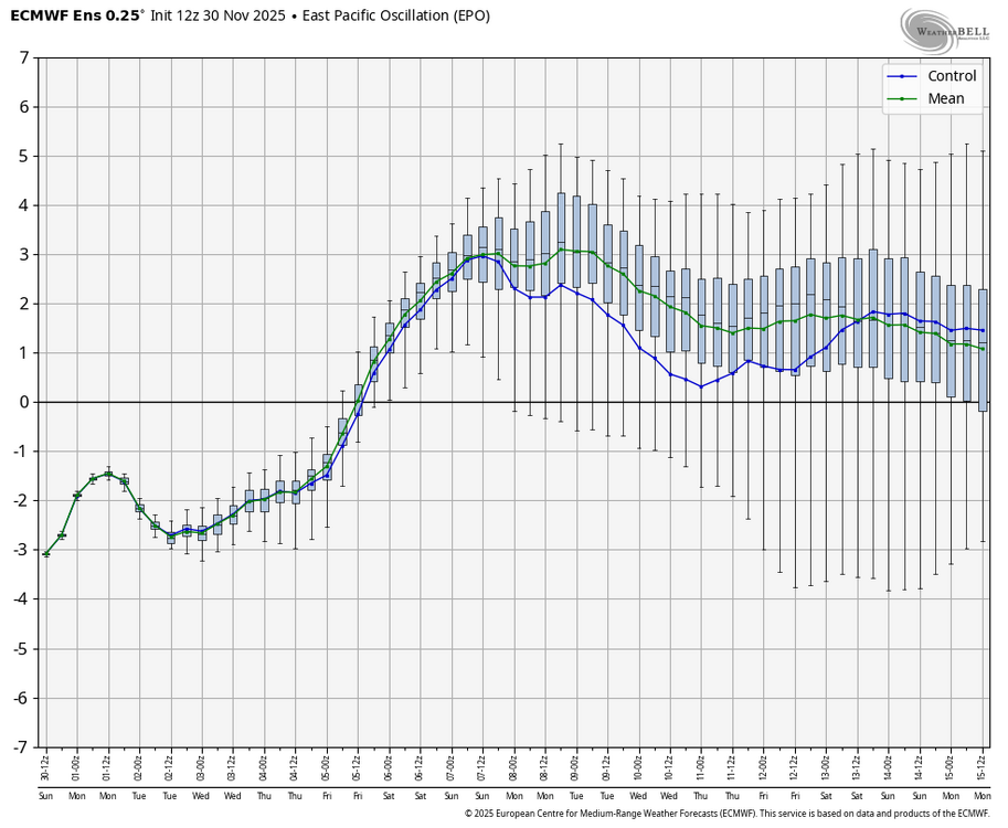
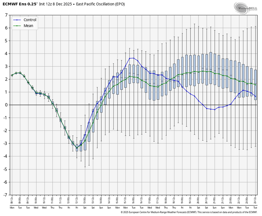
Models have been placing the block too far west, which impacts how much it bleeds into the EPO domain. Take the 11th-14 for example. A week ago, the EPS had a positive EPO for this time period. Now, it has a deeply negative EPO.
-
Deep winter vibes when shoveling 6” at -1F ha.
-
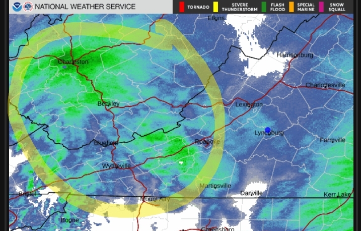
Current observation at Wakefield is Heavy Snow with 1/4 mile visibility. They have a WSW with expected totals between 3-6”. Looks like the corridor between Richmond and Newport News gets the JP.
-
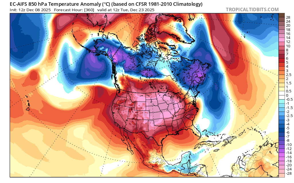
Today’s Euro Weeklies for week 3+ are still lacking cold domination to return to most of the E US south of the N tier with a solid -PNA dominating through mid Jan along with no -NAO or -AO. If this verifies, it would likely be pretty mild in much of the E US and nothing like we’ve been experiencing the last 2 weeks. However, models the last 3 weeks have been too warm in the E US with too much SER and missing much of the -NAO and -AO. Also, Midwest snowcover is well above avg, there’s the potential lag effects from the 11/28/25 SSWE, and the MJO remains favorable for E US cold. Are the weeklies/models finally getting their act together or are they going to continue with the same errors? Opinions?
-

The Monday wintry event potential (12/8/25)
NorthHillsWx replied to GaWx's topic in Southeastern States
Down to 33 with steady light snow -
Yep, even down this way flake size has decreased most of the afternoon. Right now it is POURING snow, but flakes range from pixie to eraser end size. Still, snow is snow. Down two degrees in 30 minutes, currently 26.1/23.4 with a NNE wind 7 gusting 14 mph.
-
Actually had light snow you could see without really looking hard for a few mins. Now just drizzle.
-
Boom? I like booms. Especially in winter. Snow is part of my therapy. You have my attention.
-

-

December 2025 regional war/obs/disco thread
Snowcrazed71 replied to Torch Tiger's topic in New England
Have faith little grasshopper. Ours is coming -
Nice snow shower working through
-

E PA/NJ/DE Winter 2025-26 Obs/Discussion
Mikeymac5306 replied to LVblizzard's topic in Philadelphia Region
I'll be in the Poconos driving back Monday night so book it! -
Works for me. There's a big difference between upper 40s for highs, than low 60s for days on end.
-
For reference, it’s colder than 0z, but still has AN temps most of that week. Just keeps the ridge axis more in the center of the country vs over us. But maybe a step toward again muting west coast troughing and an east coast warmup.
-

Winter 2025-26 Short Range Discussion
roardog replied to SchaumburgStormer's topic in Lakes/Ohio Valley
18Z Nam with another nudge south. -
I was looking at radar optimistic we had a couple more hours of good snowfall but you're right where its now started to decrease rates even further.
-
In great winter storm patterns over the years for our area, it wasn’t unusual for at least one of the long range model runs to correctly see the storm potential. During late January and early February 2021, it was an OP GEM run that had a correct KU forecast from a week out. With the poor storm track patterns for big snows since February 2022, none of those OP runs showing numerous KUs long range have verified.