All Activity
- Past hour
-

Pittsburgh/Western PA WINTER ‘25/‘26
colonel717 replied to Burghblizz's topic in Upstate New York/Pennsylvania
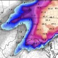
NAM gives the area 3-4 inches but still 48 hours away. -

Predict the cold contest (for Feb 7-9)
dmillz25 replied to Roger Smith's topic in New York City Metro
Max- 19 Min- 5 Snow-0.7” -
Flurries brightwaters 31
-
RGEM wants nothing to do with this. Shame it's not on board.
-

Friday February 6 FROPA / WINDEX small event
Damage In Tolland replied to HoarfrostHubb's topic in New England
Thanks! -

Friday February 6 FROPA / WINDEX small event
HoarfrostHubb replied to HoarfrostHubb's topic in New England
It's always nice to get a wintery surprise -
Already at freezing mark here in Queens. Should blow right through mid 30s today. Always use model forecasts of temps with a grain of salt. During heat waves, they're often several degrees too warm and during cold snaps, they're often several degrees too cold. Our thaw continues. Looking into the future: 1. Model guidance is indicating around 1" of snow for most of Saturday morning. Certainly cold enough for it as well 2 Looks to be 2 separate threats for late next week (one around 14th, and one around 16th) Maybe it's possible both blend into one distinct threat for next weekend, or maybe two separate ones? After that, it looks like a trough gets pushed into the west, which is probably our best bet for warm temperatures this month.
-

February 2026 OBS & Discussion
donsutherland1 replied to Stormlover74's topic in New York City Metro
I've done the Coney Island polar plunge a few times. -
They did that a lot back then with the major storms. I mean, can anyone recall big CAA winds after a damaging LLJ on the front end?
-

Friday February 6 FROPA / WINDEX small event
SouthCoastMA replied to HoarfrostHubb's topic in New England
Downplaying seems to work wonders. -
WxUSAF's weak ass frontal passage thing.
MountainGeek replied to dailylurker's topic in Mid Atlantic
Yeah it's kind of interesting that the overall dry/minor drought thing has persisted from the summer, fall, and right into winter even with the various large-scale pattern changes. Usually it tends to snap back at some point..... -
I am pretty sure other than tonight's near non event that we are likely done for the year. I know that stings for our Wake County folks who want a makeup event for the dry slot. After the warm up we get into much more difficult territory for a big hit. Obviously it certainly would not be the 20:1 type ratios. It would likely be a paste job (which is good for photos but can cause a lot more issues). I am not sure when RDU will get another shot at 6 or better but it won't be anytime soon (possibly years). I do hope we get some decent severe chances at least in the Spring.
-

Friday February 6 FROPA / WINDEX small event
CoastalWx replied to HoarfrostHubb's topic in New England
Congrats on nam -
Mid-Long Range Discussion 2026
WinstonSalemArlington replied to BooneWX's topic in Southeastern States
Believe it or not…. -
Wet bulb temp running 4 degrees below forecast at GSO
-
seems the ai gfs/euro are 1-3"/2-4 with a little redevelopment of that clipper, but not much support from the gefs at 0z anyway
-
Time for a refresher for the black ice piles in the parking lots.
-
Probably not in Feb, but I could see it happening sometime in March.
-
Central PA Winter 25/26 Discussion and Obs
pawatch replied to MAG5035's topic in Upstate New York/Pennsylvania
My problem going off the NWS for Williamsport is the temperature reading is taken at the Montourville Airport. That about 8 miles away from my location. Temperature and weather often differs. -
February 2026 Medium/ Long Range Discussion: Buckle Up!
Ji replied to Weather Will's topic in Mid Atlantic
how much did you get in the Jan 25 storm? -
What has amazed me is the lack of minor events during the latest cold period. Usually up here, and one of the things I like most about this location, is when it's legitimately cold we are almost guaranteed to at least get minor events. An inch or two from a clipper, a cold front, a lake effect band that makes it... in over 20 years up here I can't remember another significant stretch this cold that was completely totally dry like this without even those minor nickel and dime events.
-
AI Euro has a nice event next weekend... although I guess it startes earlier than that as SouthCoast said
-

2025-2026 ENSO
40/70 Benchmark replied to 40/70 Benchmark's topic in Weather Forecasting and Discussion
Not gonna happen IMO. -
Central PA Winter 25/26 Discussion and Obs
pasnownut replied to MAG5035's topic in Upstate New York/Pennsylvania
You might wanna check that station pal. Harrisburg, Harrisburg International Airport (KMDT) Lat: 40.19°NLon: 76.76°WElev: 312ft. A Few Clouds 28°F -2°C Humidity 53% Wind Speed N 12 mph Barometer 30.25 in (1025.0 mb) Dewpoint 13°F (-11°C) Visibility 10.00 mi Wind Chill 18°F (-8°C) Last update 4 Feb 8:56 am EST More Information: Local Forecast OfficeMore Local Wx3 Day HistoryHourly Weather Forecast Extended Forecast for Elizabethtown PA

