All Activity
- Past hour
-
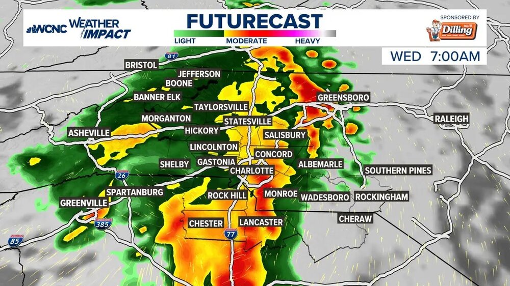
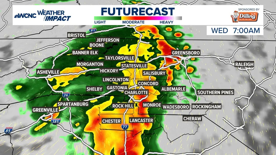
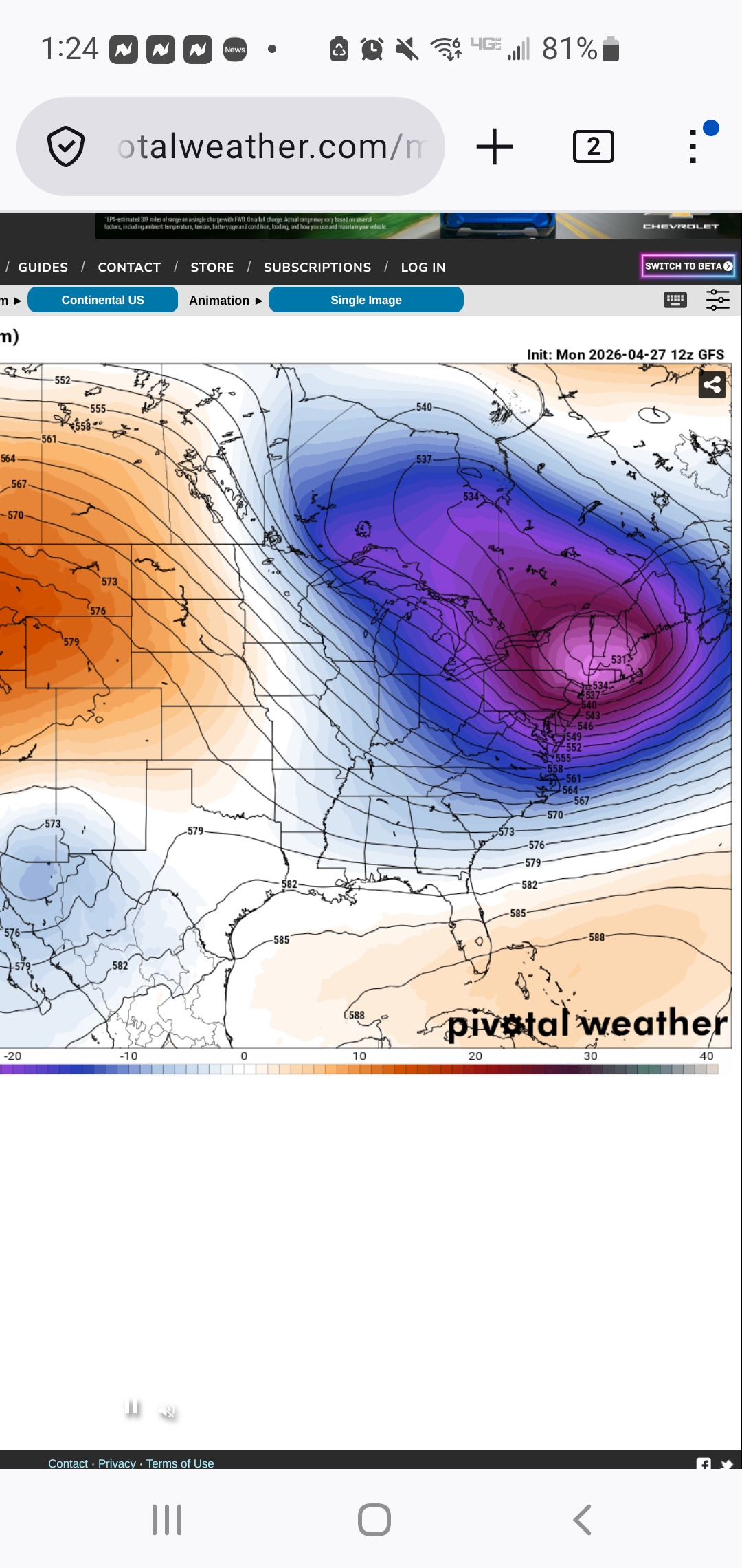
"Show me the pretty colors 48 hours out" Cmon, dont let me down now.
-
We May '05:
-
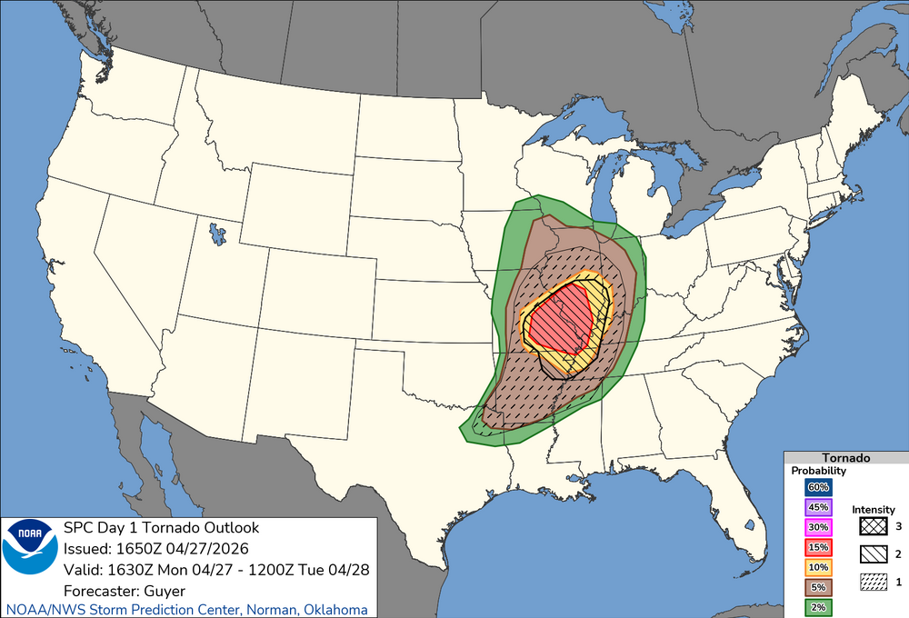
Monday 16:30 Day 1 update looks similar to 13Z. Moderate looks good. Our Mid-South will has almost as great a risk with prefrontal convergence and outflow left from this morning. The latter is a little diffuse but as of Noon Central Time had lifted just north of Dyersburg. Everything from the Missouri synoptic boundary to the convergence zones in Arkansas should light up this afternoon. Initial afternoon tornado threat West Tennessee and West Kentucky should evolve into straight winds this evening. This is the western third of our forum - not much east but thunderstorms tonight. Tuesday looks volatile enough to justify Enhanced in Arkansas with the update here in a few minutes. CAMs are nearly unanimous with outflow from today lifting north out of the Deep South into the Mid-South. Models have a clear boundary from the wind shift to the temps and dews. Synoptic boundary may be up on the Ohio River. Boundary I'm eyeing may be as far south as Memphis into Arkansas; otherwise, north of I-40 by Tue afternoon. Wind shear all levels will be robust that far south. In this case, on Tuesday, I'm much more interested in the cooking outflow boundary than the cooler synoptic one.
-
Your morning soaker is about my monthly total locally. Still under an inch
-
New outlook nudged things a bit south
-
Mid-day update from SPC edges slight risk a bit more south into NE TX/NW LA. HRRR very consistent with storms from Dallas eastward.
-
Nice morning soaking with 0.73". Brings April up to 7.46". Maybe some bonus showers later but main show likely over.
-
Still mostly cloudy here and 59. Crazy how long the fog can last here
-
Looked on point except for two days. Good forecast .
-

2026 Mid-Atlantic Severe Storm General Discussion
SnowenOutThere replied to Kmlwx's topic in Mid Atlantic
SPC has us in a day three marginal risk which prompted me to take a look NAM has a line of broken storms enter the region after a bit of clearing with 1000 CAPE values running right along I-64. We have 40-50kt of bulk shear and a good bit of lower level turning. Reminds me a bit of March 15th but less extreme and maybe a bit more heating. Wonder what yall think about it -
The rain gives it a certain vibe. I don't mind it when I'm walking around UVA.
-
Early to Mayorch 10 or so is normal here for Oaks . They leafed out early last week
-
I picked up 0.48" from the solid rain shield this morning. My April total is 7.19".
-

Potential Sever Weather Outbreak 4/27/2026
SchaumburgStormer replied to pen_artist's topic in Lakes/Ohio Valley
Game over for 72 north, but digging the rain -
remember these?
.thumb.png.122b0a0ff0d363266ed531b083d0ff20.png.43f05d63be8df057a4b26e7c0af599b4.png)
-
Lolz. A day or two maybe. https://www.usanpn.org/data/maps/spring
- Today
-
Pushing 70 now…absolutely prefect out there.
-
Or any day, period.
-
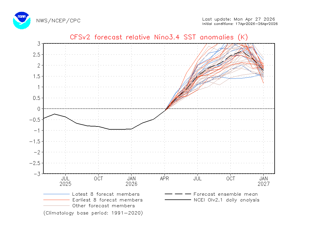
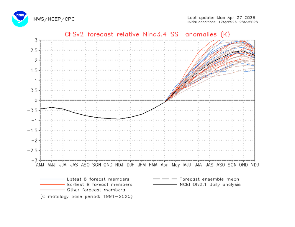
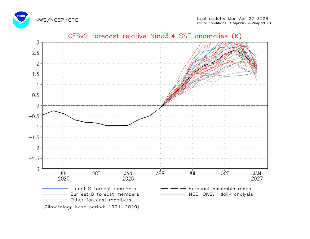
I have the most recent CFS RONI mean peak at near the 1982-3 record of +2.5 rather than +2.7: It is the monthly of Nov that peaks near +2.7, which is near the 1982-3 monthly peak of +2.69 (Jan peak): So, the most recent CFS has warmed to a 1982-3 redux in strength.
-
Average is generally low-mid 60's in early May
-
Well, Sunday looks ruined again. F
-
isn't that the average high for your area in the first half of May? I don't think we're much higher here...I'll take 70 and sun any day in May
-

2026-2027 El Nino
snowman19 replied to Stormchaserchuck1's topic in Weather Forecasting and Discussion
If the new CFS has a clue, there may not be a big disconnect between the traditional ONI and the RONI. It has the RONI peaking at around +2.7C and the traditional ONI peaking at around +3.1C in the November/December time frame. If (IF) correct, it would set a new RONI record, which currently stands at +2.5C for the 1982-83 super El Niño -
yeah i'd say this map from May - August is jackpot. Very comfortable.
-
53° feels like 65, given how many days we've had in the 40's this month


.thumb.gif.f92b16c631a1d15d405ed77b33f0710d.gif)