

cstrunk
-
Posts
608 -
Joined
-
Last visited
About cstrunk

Recent Profile Visitors
4,160 profile views


-
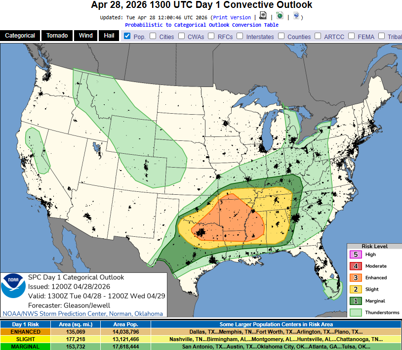
Slight risk for severe thunderstorms in parts of N/NE Texas this evening, if the cap can break. If North Texas can see more sun today, there will be a higher chance of storms. Large hail would be the main threat, but all hazards would be possible. The HRRR shows storms firing over DFW around 6 pm. Higher threats exist farther northeast in Arkansas/Tennessee. Similar story tomorrow for parts of Central/East Texas. Higher severe threats farther east into southern Arkansas, Louisiana, and Mississippi.
-
Nice cool weather yesterday and today with more rain to good chunks of the state. Should have a nice break for a few days to help dry out a bit before more chances mid-late next week.
-
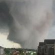
Another, perhaps more significant, severe weather outbreak is on tap for much of north/northeast Texas today. Already a severe thunderstorm near Wichita Falls. https://www.spc.noaa.gov/products/outlook/day1otlk.html Very large/giant hail possible, in addition to strong wind and a few tornadoes, especially this afternoon into this evening.
-
Mid-day update from SPC edges slight risk a bit more south into NE TX/NW LA. HRRR very consistent with storms from Dallas eastward.
-
Slight risk today has been stretched SW into NE Texas. Last few runs of the HRRR is showing some storms late this afternoon/evening forming near Dallas and points east. There's also potential for isolated storms south/west. Hail/wind is probably the biggest threat, with isolated tornadoes still a possibility. Tomorrow will have another threat for severe weather with storms potentially initiating near Sherman and headed south/east from there.
-
I think we've had 4 tornado warnings in Longview this year. No touchdowns that I'm aware of. Last night sure was close to another as the rotation was headed towards Longview again but the storm weakened as it got here, thankfully. This evening will be interesting again for the same areas of SE OK down towards Paris/Texarkana. Not sure how far south storms will make it or if they'll be very strong by the time they reach Longview. There's a stationary boundary stretching from roughly Ardmore-Sherman-Tyler-Nacogdoches. That may help focus storms, we shall see.
-
This forum has really died out. Decent chance at some severe weather in NE TX this evening. Storms in SE OK should move into NE TX. May be more of a linear wind/hail threat, but isolated tornado threat with any cell that can form/stay isolated and ahead of the outflow boundary.
-
My Father-in-Law is without power in Henderson. Since 12:30 am.
-
Not much freezing rain in north Longview from this event. Less than 0.1". 1.5"-2" sleet. QPF way underperformed. Pretty much all models had a 2"+ bullseye in NE TX. Isolated areas may have verified but I'm guessing precip was overdone for many areas.
-
Yep quiet afternoon. Sleet has returned. I feel like it'll all be sleet. Maybe some flakes at daybreak. Temps in the mid-20's.
-
Heavy sleet in Longview right now at 31F.
-
Storms in south Texas with the initial wave may rob some moisture somewhere in E/NE Texas. Something that may limit total precip from 1.5"-2" down to maybe 1" in some places.
-
I hope you are right and Longview gets 0.25" or less freezing rain. The ISW calls for 0.5"-0.75" with up to 1" of ice, but as aggiegeog noted, we seem to be dancing along a fine line.
-
Devastating ice storm potential for the general vicinity of the Arklatex and a bit south and east of there. Many models are showing fairly large areas of 1"+ of ice.
-
Decent severe weather threat for much of east Texas into LA/MS this afternoon into tonight. Could see a few sky noodles.

