cheese007
-
Posts
1,637 -
Joined
-
Last visited
About cheese007

Recent Profile Visitors
6,270 profile views


-
Parts of CA coast added to warning area WEAK51 PAAQ 300327 TSUAK1 BULLETIN Public Tsunami Message Number 5 NWS National Tsunami Warning Center Palmer AK 827 PM PDT Tue Jul 29 2025 UPDATES ------- * Revised alert areas ...THE TSUNAMI WARNING REMAINS IN EFFECT... ...THE TSUNAMI ADVISORY REMAINS IN EFFECT... Tsunami Warning in Effect for; * CALIFORNIA, The coast from Cape Mendocino, California to The Oregon/Cal. Border * ALEUTIAN ISLANDS, Samalga Pass, Alaska (30 miles SW of Nikolski) to Attu, Alaska including the Pribilof Islands Tsunami Advisory in Effect for; * CALIFORNIA, The coast from The Cal./Mexico Border to Cape Mendocino, California including San Francisco Bay * OREGON, The coast from The Oregon/Cal. Border to The Oregon/Wash. Border including the Columbia River estuary coast * WASHINGTON, Outer coast from the Oregon/Washington border to Slip Point, Columbia River estuary coast, and the Juan de Fuca Strait coast * BRITISH COLUMBIA, The north coast and Haida Gwaii, the central coast and northeast Vancouver Island, the outer west coast of Vancouver Island, the Juan de Fuca Strait coast * SOUTH ALASKA AND THE ALASKA PENINSULA, Pacific coasts from Chignik Bay, Alaska to Unimak Pass, Alaska (80 miles NE of Unalaska) * ALEUTIAN ISLANDS, Unimak Pass, Alaska (80 miles NE of Unalaska) to Samalga Pass, Alaska (30 miles SW of Nikolski) For other US and Canadian Pacific coasts in North America, there is no tsunami threat. FORECASTS OF TSUNAMI ACTIVITY ----------------------------- * A tsunami has been generated. The first waves are forecasted to arrive at the following locations and specified times. * Forecast tsunami duration is the approximate length of time which the tsunami may produce dangerous currents and waves. * Forecast max tsunami height is the highest expected water level above the tide. * Forecasts are not provided for sites which have been impacted more than an hour prior to the time of this message. FORECAST FORECAST FORECAST START TSUNAMI MAX TSUNAMI SITE OF TSUNAMI DURATION HEIGHT ---- ---------- -------- ------------- * Alaska Saint Paul 1855 AKDT Jul 29 less than 1ft * British Columbia Langara 2205 PDT Jul 29 less than 1ft Tofino 2330 PDT Jul 29 less than 1ft * Oregon Port Orford 2335 PDT Jul 29 15 hrs 0.9- 1.7 ft Charleston 2345 PDT Jul 29 less than 1ft Brookings 2350 PDT Jul 29 9 hrs 0.8- 1.4 ft Seaside 2355 PDT Jul 29 Newport 2355 PDT Jul 29 * Washington La Push 2335 PDT Jul 29 Neah Bay 2340 PDT Jul 29 less than 1ft Long Beach 2345 PDT Jul 29 less than 1ft Westport 2350 PDT Jul 29 less than 1ft Moclips 2350 PDT Jul 29 less than 1ft Port Angeles 0015 PDT Jul 30 less than 1ft Port Townsend 0045 PDT Jul 30 less than 1ft Bellingham 0110 PDT Jul 30 less than 1ft Tacoma 0200 PDT Jul 30 * California Fort Bragg 2350 PDT Jul 29 9 hrs 0.7- 1.3 ft Crescent City 2350 PDT Jul 29 30 hrs 2.6- 4.8 ft Monterey 0015 PDT Jul 30 less than 1ft Port San Luis 0035 PDT Jul 30 24 hrs 2.0- 3.7 ft San Francisco 0040 PDT Jul 30 less than 1ft Santa Barbara 0045 PDT Jul 30 less than 1ft Los Angeles Harb 0100 PDT Jul 30 less than 1ft Newport Beach 0110 PDT Jul 30 less than 1ft La Jolla 0110 PDT Jul 30 less than 1ft Oceanside 0115 PDT Jul 30 less than 1ft OBSERVATIONS OF TSUNAMI ACTIVITY - UPDATED ------------------------------------------ * Observed max tsunami height is the highest recorded water level above the tide level up to the time of this message. TIME OBSERVED MAX SITE OF MEASUREMENT TSUNAMI HEIGHT ---------------------------- ---------------- -------------- Amchitka Alaska 0.8ft Adak Alaska 0.9ft Kushiro Japan 1.1ft Abashiri Japan 0.7ft Hanasaki Japan 1.1ft Nikolskoe Russia 1714 PDT Jul 29 0.2ft PRELIMINARY EARTHQUAKE PARAMETERS --------------------------------- * Magnitude 8.8 * Origin Time 1525 AKDT Jul 29 2025 1625 PDT Jul 29 2025 2325 UTC Jul 29 2025 * Coordinates 52.2 North 160.0 East * Depth 46 miles * Location 315 miles SW of Bering I., Komandorski 80 miles SE of Petropavlovsk, Kamchatka RECOMMENDED ACTIONS ------------------- * See message number 4 for recommended actions. IMPACTS ------- * See message number 4 for possible impacts. ADDITIONAL INFORMATION AND NEXT UPDATE -------------------------------------- * Refer to the internet site tsunami.gov for more information. * Pacific coastal residents outside California, Oregon, Washington, British Columbia and Alaska should refer to the Pacific Tsunami Warning Center messages at tsunami.gov. * This message will be updated within 60 minutes. $$
-
July 2025 Obs/Disco ... possible historic month for heat
cheese007 replied to Typhoon Tip's topic in New England
Started a thread in the relevant subforum so info wouldn't be subsumed into a random thread here -
https://www.tsunami.gov/events/PAAQ/2025/07/29/t06p1k/3/WEAK51/WEAK51.txt ZCZC WEHW40 PHEB 300151 TSUHWX HIZ001-003-006>007-009-016>018-023-026-029>035-037>050-051>054- 300351- /O.CON.PHEB.TS.W.0001.000000T0000Z-000000T0000Z/ BULLETIN TSUNAMI MESSAGE NUMBER 4 NWS PACIFIC TSUNAMI WARNING CENTER HONOLULU HI 351 PM HST TUE JUL 29 2025 TO - EMERGENCY MANAGEMENT IN THE STATE OF HAWAII SUBJECT - TSUNAMI WARNING SUPPLEMENT A TSUNAMI WARNING CONTINUES IN EFFECT FOR THE STATE OF HAWAII. AN EARTHQUAKE HAS OCCURRED WITH THESE PRELIMINARY PARAMETERS ORIGIN TIME - 0125 PM HST 29 JUL 2025 COORDINATES - 52.2 NORTH 160.0 EAST LOCATION - OFF THE EAST COAST OF KAMCHATKA RUSSIA MAGNITUDE - 8.7 MOMENT MEASUREMENTS OR REPORTS OF TSUNAMI WAVE ACTIVITY GAUGE LOCATION LAT LON TIME AMPL PER ------------------- ----- ------ ----- --------------- ----- DART 21414 49.0N 178.2E 0103Z 0.28M / 0.9FT 32MIN DART 21416 48.1N 163.5E 0003Z 0.90M / 3.0FT 24MIN LAT - LATITUDE (N-NORTH, S-SOUTH) LON - LONGITUDE (E-EAST, W-WEST) TIME - TIME OF THE MEASUREMENT (Z IS UTC IS GREENWICH TIME) AMPL - TSUNAMI AMPLITUDE MEASURED RELATIVE TO NORMAL SEA LEVEL. IT IS ...NOT... CREST-TO-TROUGH WAVE HEIGHT. VALUES ARE GIVEN IN BOTH METERS(M) AND FEET(FT). PER - PERIOD OF TIME IN MINUTES(MIN) FROM ONE WAVE TO THE NEXT. NOTE - DART MEASUREMENTS ARE FROM THE DEEP OCEAN AND THEY ARE GENERALLY MUCH SMALLER THAN WOULD BE COASTAL MEASUREMENTS AT SIMILAR LOCATIONS. EVALUATION A TSUNAMI HAS BEEN GENERATED THAT COULD CAUSE DAMAGE ALONG COASTLINES OF ALL ISLANDS IN THE STATE OF HAWAII. URGENT ACTION SHOULD BE TAKEN TO PROTECT LIVES AND PROPERTY. A TSUNAMI IS A SERIES OF LONG OCEAN WAVES. EACH INDIVIDUAL WAVE CREST CAN LAST 5 TO 15 MINUTES OR MORE AND EXTENSIVELY FLOOD COASTAL AREAS. THE DANGER CAN CONTINUE FOR MANY HOURS AFTER THE INITIAL WAVE AS SUBSEQUENT WAVES ARRIVE. TSUNAMI WAVE HEIGHTS CANNOT BE PREDICTED AND THE FIRST WAVE MAY NOT BE THE LARGEST. TSUNAMI WAVES EFFICIENTLY WRAP AROUND ISLANDS. ALL SHORES ARE AT RISK NO MATTER WHICH DIRECTION THEY FACE. THE TROUGH OF A TSUNAMI WAVE MAY TEMPORARILY EXPOSE THE SEAFLOOR BUT THE AREA WILL QUICKLY FLOOD AGAIN. EXTREMELY STRONG AND UNUSUAL NEARSHORE CURRENTS CAN ACCOMPANY A TSUNAMI. DEBRIS PICKED UP AND CARRIED BY A TSUNAMI AMPLIFIES ITS DESTRUCTIVE POWER. SIMULTANEOUS HIGH TIDES OR HIGH SURF CAN SIGNIFICANTLY INCREASE THE TSUNAMI HAZARD. THE ESTIMATED ARRIVAL TIME IN HAWAII OF THE FIRST TSUNAMI WAVE IS 0717 PM HST TUE 29 JUL 2025 FURTHER MESSAGES WILL BE ISSUED HOURLY OR SOONER AS CONDITIONS WARRANT UNTIL THE THREAT TO HAWAII HAS PASSED. $$ NNNN https://www.tsunami.gov/events/PHEB/2025/07/29/25210002/4/WEHW40/WEHW40.txt ZCZC WEPA40 PHEB 300150 TSUPAC TSUNAMI MESSAGE NUMBER 4 NWS PACIFIC TSUNAMI WARNING CENTER HONOLULU HI 0148 UTC WED JUL 30 2025 ...PTWC TSUNAMI THREAT MESSAGE... **** NOTICE **** NOTICE **** NOTICE **** NOTICE **** NOTICE ***** THIS MESSAGE IS ISSUED FOR INFORMATION ONLY IN SUPPORT OF THE UNESCO/IOC PACIFIC TSUNAMI WARNING AND MITIGATION SYSTEM AND IS MEANT FOR NATIONAL AUTHORITIES IN EACH COUNTRY OF THAT SYSTEM. NATIONAL AUTHORITIES WILL DETERMINE THE APPROPRIATE LEVEL OF ALERT FOR EACH COUNTRY AND MAY ISSUE ADDITIONAL OR MORE REFINED INFORMATION. **** NOTICE **** NOTICE **** NOTICE **** NOTICE **** NOTICE ***** THE TSUNAMI FORECAST IS UPDATED IN THIS MESSAGE. PRELIMINARY EARTHQUAKE PARAMETERS --------------------------------- * MAGNITUDE 8.7 * ORIGIN TIME 2325 UTC JUL 29 2025 * COORDINATES 52.2 NORTH 160.0 EAST * DEPTH 74 KM / 46 MILES * LOCATION OFF THE EAST COAST OF KAMCHATKA RUSSIA EVALUATION ---------- * AN EARTHQUAKE WITH A PRELIMINARY MAGNITUDE OF 8.7 OCCURRED OFF THE EAST COAST OF KAMCHATKA, RUSSIA AT 2325 UTC ON TUESDAY JULY 29 2025. * TSUNAMI WAVES HAVE BEEN OBSERVED. * BASED ON ALL AVAILABLE DATA... HAZARDOUS TSUNAMI WAVES ARE FORECAST FOR SOME COASTS. TSUNAMI THREAT FORECAST...UPDATED --------------------------------- * TSUNAMI WAVES REACHING MORE THAN 3 METERS ABOVE THE TIDE LEVEL ARE POSSIBLE ALONG SOME COASTS OF ECUADOR... NORTHWESTERN HAWAIIAN ISLANDS... AND RUSSIA. * TSUNAMI WAVES REACHING 1 TO 3 METERS ABOVE THE TIDE LEVEL ARE POSSIBLE ALONG SOME COASTS OF CHILE... COSTA RICA... FRENCH POLYNESIA... GUAM... HAWAII... JAPAN... JARVIS ISLAND... JOHNSTON ATOLL... KIRIBATI... MIDWAY ISLAND... PALMYRA ISLAND... PERU... SAMOA... AND SOLOMON ISLANDS. * TSUNAMI WAVES REACHING 0.3 TO 1 METERS ABOVE THE TIDE LEVEL ARE POSSIBLE FOR SOME COASTS OF ANTARCTICA... AUSTRALIA... CHUUK... COLOMBIA... COOK ISLANDS... EL SALVADOR... FIJI... GUATEMALA... HOWLAND AND BAKER... INDONESIA... KERMADEC ISLANDS... KOSRAE... MARSHALL ISLANDS... MEXICO... NAURU... NEW CALEDONIA... NEW ZEALAND... NICARAGUA... NIUE... NORTHERN MARIANAS... PALAU... PANAMA... PAPUA NEW GUINEA... PHILIPPINES... PITCAIRN ISLANDS... POHNPEI... TAIWAN... TOKELAU... TONGA... TUVALU... VANUATU... WAKE ISLAND... WALLIS AND FUTUNA... AMERICAN SAMOA... AND YAP. * TSUNAMI WAVES ARE FORECAST TO BE LESS THAN 0.3 METERS ABOVE THE TIDE LEVEL FOR THE COASTS OF BRUNEI... CHINA... DPR OF KOREA... MALAYSIA... REPUBLIC OF KOREA... AND VIETNAM. * ACTUAL AMPLITUDES AT THE COAST MAY VARY FROM FORECAST AMPLITUDES DUE TO UNCERTAINTIES IN THE FORECAST AND LOCAL FEATURES. IN PARTICULAR MAXIMUM TSUNAMI AMPLITUDES ON ATOLLS AND AT LOCATIONS WITH FRINGING OR BARRIER REEFS WILL LIKELY BE MUCH SMALLER THAN THE FORECAST INDICATES. * FOR OTHER AREAS COVERED BY THIS PRODUCT A FORECAST HAS NOT YET BEEN COMPUTED. THE FORECAST WILL BE EXPANDED IF NECESSARY IN SUBSEQUENT PRODUCTS. RECOMMENDED ACTIONS ------------------- * GOVERNMENT AGENCIES RESPONSIBLE FOR THREATENED COASTAL AREAS SHOULD TAKE ACTION TO INFORM AND INSTRUCT ANY COASTAL POPULATIONS AT RISK IN ACCORDANCE WITH THEIR OWN EVALUATION... PROCEDURES AND THE LEVEL OF THREAT. * PERSONS LOCATED IN THREATENED COASTAL AREAS SHOULD STAY ALERT FOR INFORMATION AND FOLLOW INSTRUCTIONS FROM NATIONAL AND LOCAL AUTHORITIES. ESTIMATED TIMES OF ARRIVAL -------------------------- * ESTIMATED TIMES OF ARRIVAL -ETA- OF THE INITIAL TSUNAMI WAVE FOR PLACES WITHIN THREATENED REGIONS ARE GIVEN BELOW. ACTUAL ARRIVAL TIMES MAY DIFFER AND THE INITIAL WAVE MAY NOT BE THE LARGEST. A TSUNAMI IS A SERIES OF WAVES AND THE TIME BETWEEN WAVES CAN BE FIVE MINUTES TO ONE HOUR. LOCATION REGION COORDINATES ETA(UTC) ------------------------------------------------------------ SEVERO KURILSK RUSSIA 50.8N 156.1E 0110 07/30 KUSHIRO JAPAN 42.9N 144.3E 0132 07/30 HACHINOHE JAPAN 40.5N 141.5E 0212 07/30 KATSUURA JAPAN 35.1N 140.3E 0222 07/30 HACHIJO JIMA JAPAN 33.1N 139.8E 0234 07/30 CHICHI JIMA JAPAN 27.0N 142.2E 0303 07/30 MINAMITORISHIMA MINAMITORISHIMA 24.3N 154.0E 0311 07/30 MIDWAY ISLAND MIDWAY ISLAND 28.2N 177.4W 0327 07/30 GASTELLO RUSSIA 49.1N 143.0E 0339 07/30 SAPPORO JAPAN 43.5N 141.0E 0340 07/30 SHIMIZU JAPAN 32.8N 133.0E 0344 07/30 WAKE ISLAND WAKE ISLAND 19.3N 166.6E 0350 07/30 NOBEOKA JAPAN 32.5N 131.8E 0350 07/30 LISIANSKI NORTHWEST HAWAII 26.1N 174.0W 0355 07/30 NIIGATA JAPAN 38.0N 139.0E 0359 07/30 LAYSAN NORTHWEST HAWAII 25.8N 171.7W 0402 07/30 FRENCH FRIGATE NORTHWEST HAWAII 23.9N 166.3W 0432 07/30 SAIPAN NORTHERN MARIANA 15.3N 145.8E 0436 07/30 NECKER NORTHWEST HAWAII 23.6N 164.7W 0439 07/30 NIHOA NORTHWEST HAWAII 23.1N 161.9W 0454 07/30 GUAM GUAM 13.4N 144.7E 0457 07/30 SHIMANE JAPAN 35.8N 133.0E 0458 07/30 OKINAWA JAPAN 26.2N 127.8E 0500 07/30 ENIWETOK MARSHALL ISLANDS 11.4N 162.3E 0509 07/30 NAWILIWILI HAWAII 22.0N 159.4W 0517 07/30 HUALIEN TAIWAN 24.0N 121.7E 0519 07/30 JOHNSTON ISLAND JOHNSTON ISLAND 16.7N 169.5W 0520 07/30 KWAJALEIN MARSHALL ISLANDS 8.7N 167.7E 0521 07/30 TAITUNG TAIWAN 22.7N 121.2E 0524 07/30 HONOLULU HAWAII 21.3N 157.9W 0531 07/30 YAP ISLAND YAP 9.5N 138.1E 0532 07/30 NAGASAKI JAPAN 32.7N 129.7E 0533 07/30 KAHULUI HAWAII 20.9N 156.5W 0537 07/30 PALANAN PHILIPPINES 17.1N 122.6E 0542 07/30 POHNPEI ISLAND POHNPEI 7.0N 158.2E 0542 07/30 MAJURO MARSHALL ISLANDS 7.1N 171.4E 0543 07/30 KOSRAE ISLAND KOSRAE 5.5N 163.0E 0543 07/30 CHILUNG TAIWAN 25.2N 121.8E 0552 07/30 HILO HAWAII 19.7N 155.1W 0555 07/30 KAOHSIUNG TAIWAN 22.5N 120.3E 0606 07/30 LAOAG PHILIPPINES 18.2N 120.6E 0607 07/30 CHUUK ISLAND CHUUK 7.4N 151.8E 0612 07/30 MALAKAL PALAU 7.3N 134.5E 0612 07/30 LEGASPI PHILIPPINES 13.2N 123.8E 0613 07/30 SAN FERNANDO PHILIPPINES 16.6N 120.3E 0627 07/30 GEME INDONESIA 4.6N 126.8E 0636 07/30 NAURU NAURU 0.5S 166.9E 0640 07/30 DAVAO PHILIPPINES 6.8N 125.7E 0640 07/30 BEREBERE INDONESIA 2.5N 128.7E 0645 07/30 HOWLAND ISLAND HOWLAND AND BAKE 0.6N 176.6W 0654 07/30 WARSA INDONESIA 0.6S 135.8E 0657 07/30 TABUKAN TENGAH INDONESIA 3.6N 125.6E 0702 07/30 KAVIENG PAPUA NEW GUINEA 2.5S 150.7E 0703 07/30 MANUS ISLAND PAPUA NEW GUINEA 2.0S 147.5E 0704 07/30 MANOKWARI INDONESIA 0.8S 134.2E 0705 07/30 PALMYRA ISLAND PALMYRA ISLAND 5.9N 162.1W 0707 07/30 PATANI INDONESIA 0.4N 128.8E 0711 07/30 COTABUTO CITY PHILIPPINES 7.2N 124.2E 0714 07/30 VANIMO PAPUA NEW GUINEA 2.6S 141.3E 0718 07/30 JAYAPURA INDONESIA 2.4S 140.8E 0719 07/30 SORONG INDONESIA 0.8S 131.1E 0722 07/30 MANADO INDONESIA 1.6N 124.9E 0723 07/30 WEWAK PAPUA NEW GUINEA 3.5S 143.6E 0730 07/30 RABAUL PAPUA NEW GUINEA 4.2S 152.3E 0733 07/30 KANTON ISLAND KIRIBATI 2.8S 171.7W 0733 07/30 KIETA PAPUA NEW GUINEA 6.1S 155.6E 0744 07/30 FUNAFUTI ISLAND TUVALU 7.9S 178.5E 0744 07/30 ULAMONA PAPUA NEW GUINEA 5.0S 151.2E 0746 07/30 HOMEL TAIWAN 24.2N 120.4E 0750 07/30 AMUN PAPUA NEW GUINEA 6.0S 154.7E 0751 07/30 CHRISTMAS ISLAN KIRIBATI 2.0N 157.5W 0751 07/30 ZAMBOANGA PHILIPPINES 7.0N 122.3E 0752 07/30 MADANG PAPUA NEW GUINEA 5.2S 145.8E 0759 07/30 PANGGOE SOLOMON ISLANDS 6.9S 157.2E 0800 07/30 JARVIS ISLAND JARVIS ISLAND 0.4S 160.1W 0801 07/30 FALAMAE SOLOMON ISLANDS 7.4S 155.6E 0802 07/30 WOODLARK ISLAND PAPUA NEW GUINEA 9.0S 152.9E 0803 07/30 GHATERE SOLOMON ISLANDS 7.8S 159.2E 0812 07/30 MUNDA SOLOMON ISLANDS 8.4S 157.2E 0818 07/30 AUKI SOLOMON ISLANDS 8.8S 160.6E 0819 07/30 NUKUNONU ISLAND TOKELAU 9.2S 171.8W 0821 07/30 KIRAKIRA SOLOMON ISLANDS 10.4S 161.9E 0822 07/30 ENSENADA MEXICO 31.8N 116.8W 0822 07/30 LAE PAPUA NEW GUINEA 6.8S 147.0E 0833 07/30 SANTA CRUZ ISLA SOLOMON ISLANDS 10.9S 165.9E 0835 07/30 WALLIS ISLAND WALLIS AND FUTUN 13.2S 176.2W 0841 07/30 HONIARA SOLOMON ISLANDS 9.3S 160.0E 0845 07/30 MANILA PHILIPPINES 14.6N 121.0E 0845 07/30 MALDEN ISLAND KIRIBATI 3.9S 154.9W 0846 07/30 PUKAPUKA ISLAND COOK ISLANDS 10.8S 165.9W 0853 07/30 FUTUNA ISLAND WALLIS AND FUTUN 14.3S 178.2W 0854 07/30 APIA SAMOA 13.8S 171.8W 0858 07/30 PAGO PAGO AMERICAN SAMOA 14.3S 170.7W 0905 07/30 ESPERITU SANTO VANUATU 15.1S 167.3E 0907 07/30 PENRYN ISLAND COOK ISLANDS 8.9S 157.8W 0908 07/30 PUNTA ABREOJOS MEXICO 26.7N 113.6W 0912 07/30 NIUATOPUTAPU TONGA 15.9S 173.8W 0915 07/30 NIUE ISLAND NIUE 19.0S 170.0W 0940 07/30 HOLEVA TONGA 18.6S 173.9W 0941 07/30 CABO SAN LUCAS MEXICO 22.8N 110.0W 0950 07/30 HIENGHENE NEW CALEDONIA 20.6S 165.0E 0951 07/30 FLINT ISLAND KIRIBATI 11.4S 151.8W 0951 07/30 ANATOM ISLAND VANUATU 20.2S 169.9E 0956 07/30 LIFOU ISL NEW CALEDONIA 20.9S 167.3E 0956 07/30 SUVA FIJI 18.1S 178.4E 0957 07/30 MARE ISL NEW CALEDONIA 21.6S 167.8E 1006 07/30 NUKUALOFA TONGA 21.0S 175.2W 1010 07/30 OUINNE NEW CALEDONIA 22.0S 166.8E 1011 07/30 RAROTONGA COOK ISLANDS 21.2S 159.8W 1031 07/30 MAZATLAN MEXICO 23.2N 106.4W 1039 07/30 HIVA OA FRENCH POLYNESIA 10.0S 139.0W 1040 07/30 NOUMEA NEW CALEDONIA 22.3S 166.5E 1044 07/30 PUERTO VALLARTA MEXICO 20.6N 105.2W 1047 07/30 PAPEETE FRENCH POLYNESIA 17.5S 149.6W 1048 07/30 RAOUL ISLAND KERMADEC ISLANDS 29.2S 177.9W 1101 07/30 MANZANILLO MEXICO 19.1N 104.3W 1105 07/30 SAN BLAS MEXICO 21.5N 105.3W 1111 07/30 LAZARO CARDENAS MEXICO 17.9N 102.2W 1126 07/30 TUBUAI FRENCH POLYNESIA 23.3S 149.5W 1129 07/30 ACAPULCO MEXICO 16.9N 99.9W 1140 07/30 BRISBANE AUSTRALIA 27.2S 153.3E 1159 07/30 LOTTIN POINT NEW ZEALAND 37.5S 178.2E 1159 07/30 NORTH CAPE NEW ZEALAND 34.4S 173.3E 1213 07/30 EAST CAPE NEW ZEALAND 37.7S 178.5E 1228 07/30 RAPA ITI FRENCH POLYNESIA 27.6S 144.3W 1229 07/30 SYDNEY AUSTRALIA 33.9S 151.4E 1230 07/30 GISBORNE NEW ZEALAND 38.7S 178.0E 1234 07/30 MOUNT MAUNGANUI NEW ZEALAND 37.6S 176.2E 1239 07/30 RIKITEA FRENCH POLYNESIA 23.1S 135.0W 1239 07/30 PORT TAURANGA NEW ZEALAND 37.7S 176.2E 1252 07/30 WELLINGTON NEW ZEALAND 41.3S 174.8E 1258 07/30 SALINA CRUZ MEXICO 16.5N 95.2W 1259 07/30 WHANGAREI NEW ZEALAND 35.8S 174.5E 1307 07/30 GLADSTONE AUSTRALIA 23.8S 151.4E 1309 07/30 KAINGAROA CHATH NEW ZEALAND 43.7S 176.3W 1310 07/30 CHAMPERICO RETA GUATEMALA 14.3N 91.9W 1314 07/30 AUCKLAND WEST NEW ZEALAND 37.1S 174.2E 1315 07/30 PUERTO MADERO MEXICO 14.8N 92.5W 1315 07/30 PITCAIRN ISLAND PITCAIRN 25.1S 130.1W 1316 07/30 MARLBOROUGH SOU NEW ZEALAND 41.1S 174.4E 1319 07/30 OCOS SAN MARCOS GUATEMALA 14.5N 92.2W 1321 07/30 TIQUISATE ESCUI GUATEMALA 14.0N 91.5W 1322 07/30 NAPIER NEW ZEALAND 39.5S 176.9E 1322 07/30 MONTERRICO SANT GUATEMALA 13.9N 90.5W 1328 07/30 WAITANGI CHATHA NEW ZEALAND 43.9S 176.6W 1330 07/30 SIPACATE GUATEMALA 13.9N 91.2W 1331 07/30 PUERTO DE SAN J GUATEMALA 13.9N 90.8W 1332 07/30 AUCKLAND EAST NEW ZEALAND 36.7S 175.0E 1335 07/30 ACAJUTLA EL SALVADOR 13.6N 89.8W 1337 07/30 PICTON NEW ZEALAND 41.3S 174.0E 1345 07/30 CABO SAN ELENA COSTA RICA 10.9N 86.0W 1349 07/30 MACKAY AUSTRALIA 21.1S 149.3E 1350 07/30 CORINTO NICARAGUA 12.5N 87.2W 1358 07/30 NEW PLYMOUTH NEW ZEALAND 39.1S 174.1E 1400 07/30 PUERTO SANDINO NICARAGUA 12.2N 86.8W 1404 07/30 JACKSON BAY NEW ZEALAND 44.0S 168.6E 1412 07/30 ISLA DEL COCO COSTA RICA 5.5N 87.1W 1412 07/30 SAN JUAN DL SUR NICARAGUA 11.2N 85.9W 1414 07/30 PUERTO QUEPOS COSTA RICA 9.4N 84.2W 1416 07/30 CABO MATAPALO COSTA RICA 8.4N 83.3W 1418 07/30 MILFORD SOUND NEW ZEALAND 44.6S 167.9E 1418 07/30 PUNTA BURICA PANAMA 8.0N 82.9W 1429 07/30 WANGANUI NEW ZEALAND 39.9S 175.0E 1432 07/30 DUNEDIN NEW ZEALAND 45.9S 170.5E 1434 07/30 WESTPORT NEW ZEALAND 41.8S 171.6E 1439 07/30 STEWART ISLAND NEW ZEALAND 47.3S 167.5E 1447 07/30 GREYMOUTH NEW ZEALAND 42.5S 171.2E 1457 07/30 TIMARU NEW ZEALAND 44.4S 171.3E 1503 07/30 LYTTELTON NEW ZEALAND 43.6S 172.7E 1508 07/30 PUNTA MALA PANAMA 7.5N 80.0W 1515 07/30 BALTRA ISLAND ECUADOR 0.5S 90.3W 1520 07/30 EASTER ISLAND CHILE 27.1S 109.4W 1522 07/30 PUERTO PINA PANAMA 7.4N 78.0W 1525 07/30 BAHIA SOLANO COLOMBIA 6.3N 77.4W 1528 07/30 ESMERELDAS ECUADOR 1.2N 79.8W 1544 07/30 TUMACO COLOMBIA 1.8N 78.9W 1552 07/30 LA LIBERTAD ECUADOR 2.2S 81.2W 1605 07/30 BUENAVENTURA COLOMBIA 3.8N 77.2W 1611 07/30 NELSON NEW ZEALAND 41.3S 173.3E 1621 07/30 TALARA PERU 4.6S 81.5W 1625 07/30 BLUFF NEW ZEALAND 46.6S 168.3E 1646 07/30 CAPE ADARE ANTARCTICA 71.0S 170.0E 1708 07/30 PIMENTAL PERU 6.9S 80.0W 1733 07/30 LA PUNTA PERU 12.1S 77.2W 1735 07/30 BALBOA HEIGHTS PANAMA 9.0N 79.6W 1736 07/30 CHIMBOTE PERU 9.0S 78.8W 1741 07/30 SAN JUAN PERU 15.3S 75.2W 1749 07/30 MOLLENDO PERU 17.1S 72.0W 1822 07/30 ARICA CHILE 18.5S 70.3W 1840 07/30 IQUIQUE CHILE 20.2S 70.1W 1845 07/30 ANTOFAGASTA CHILE 23.3S 70.4W 1854 07/30 CALDERA CHILE 27.1S 70.8W 1916 07/30 COQUIMBO CHILE 29.9S 71.4W 1926 07/30 VALPARAISO CHILE 33.0S 71.6W 1942 07/30 TALCAHUANO CHILE 36.7S 73.1W 2006 07/30 CORRAL CHILE 39.8S 73.5W 2024 07/30 GOLFO DE PENAS CHILE 47.1S 74.9W 2104 07/30 PUERTO MONTT CHILE 41.5S 73.0W 2300 07/30 POTENTIAL IMPACTS ----------------- * A TSUNAMI IS A SERIES OF WAVES. THE TIME BETWEEN WAVE CRESTS CAN VARY FROM 5 MINUTES TO AN HOUR. THE HAZARD MAY PERSIST FOR MANY HOURS OR LONGER AFTER THE INITIAL WAVE. * IMPACTS CAN VARY SIGNIFICANTLY FROM ONE SECTION OF COAST TO THE NEXT DUE TO LOCAL BATHYMETRY AND THE SHAPE AND ELEVATION OF THE SHORELINE. * IMPACTS CAN ALSO VARY DEPENDING UPON THE STATE OF THE TIDE AT THE TIME OF THE MAXIMUM TSUNAMI WAVES. * PERSONS CAUGHT IN THE WATER OF A TSUNAMI MAY DROWN... BE CRUSHED BY DEBRIS IN THE WATER... OR BE SWEPT OUT TO SEA. TSUNAMI OBSERVATIONS -------------------- * THE FOLLOWING ARE TSUNAMI WAVE OBSERVATIONS FROM COASTAL AND/OR DEEP-OCEAN SEA LEVEL GAUGES AT THE INDICATED LOCATIONS. THE MAXIMUM TSUNAMI HEIGHT IS MEASURED WITH RESPECT TO THE NORMAL TIDE LEVEL. GAUGE TIME OF MAXIMUM WAVE COORDINATES MEASURE TSUNAMI PERIOD GAUGE LOCATION LAT LON (UTC) HEIGHT (MIN) ------------------------------------------------------------- DART 21414 49.0N 178.2E 0103 0.28M/ 0.9FT 32 DART 21416 48.1N 163.5E 0003 0.90M/ 3.0FT 24 NEXT UPDATE AND ADDITIONAL INFORMATION -------------------------------------- * THE NEXT MESSAGE WILL BE ISSUED IN ONE HOUR... OR SOONER IF THE SITUATION WARRANTS. * AUTHORITATIVE INFORMATION ABOUT THE EARTHQUAKE FROM THE U.S. GEOLOGICAL SURVEY CAN BE FOUND ON THE INTERNET AT EARTHQUAKE.USGS.GOV. * FURTHER INFORMATION ABOUT THIS EVENT MAY BE FOUND AT WWW.TSUNAMI.GOV. * COASTAL REGIONS OF HAWAII... AMERICAN SAMOA... GUAM... AND CNMI SHOULD REFER TO PACIFIC TSUNAMI WARNING CENTER MESSAGES SPECIFICALLY FOR THOSE PLACES THAT CAN BE FOUND AT WWW.TSUNAMI.GOV. * COASTAL REGIONS OF CALIFORNIA... OREGON... WASHINGTON... BRITISH COLUMBIA AND ALASKA SHOULD ONLY REFER TO U.S. NATIONAL TSUNAMI WARNING CENTER MESSAGES THAT CAN BE FOUND AT WWW.TSUNAMI.GOV. $$ NNNN
-
4/2-4/3 Potential Major Severe WX Outbreak
cheese007 replied to Geoboy645's topic in Lakes/Ohio Valley
Broyles... -
Tornado Warning TXC251-439-041130- /O.NEW.KFWD.TO.W.0001.250304T1101Z-250304T1130Z/ BULLETIN - EAS ACTIVATION REQUESTED Tornado Warning National Weather Service Fort Worth TX 501 AM CST Tue Mar 4 2025 The National Weather Service in Fort Worth has issued a * Tornado Warning for... Northeastern Johnson County in north central Texas... Southern Tarrant County in north central Texas... * Until 530 AM CST. * At 500 AM CST, a severe thunderstorm capable of producing a tornado was located near Crowley, moving east at 50 mph. HAZARD...Tornado. SOURCE...Radar indicated rotation. IMPACT...Flying debris will be dangerous to those caught without shelter. Mobile homes will be damaged or destroyed. Damage to roofs, windows, and vehicles will occur. Tree damage is likely. * This dangerous storm will be near... Burleson, Rendon, Fort Worth, Crowley, and Everman around 505 AM CST. Kennedale around 510 AM CST. Arlington and Mansfield around 515 AM CST. This includes the following highways... Interstate 35W between mile markers 32 and 46. Interstate 20 between mile markers 434 and 450. PRECAUTIONARY/PREPAREDNESS ACTIONS... TAKE COVER NOW! Move to an interior room on the lowest floor of a sturdy building. Avoid windows. If you are outdoors, in a mobile home, or in a vehicle, move to the closest substantial shelter and protect yourself from flying debris. && LAT...LON 3246 9709 3249 9749 3265 9749 3272 9709 TIME...MOT...LOC 1100Z 269DEG 43KT 3258 9743 TORNADO...RADAR INDICATED MAX HAIL SIZE...<.75 IN $$ Bonnette
-
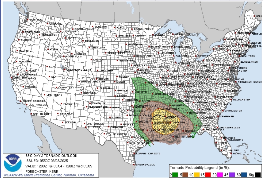
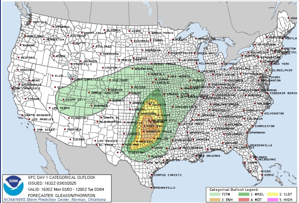
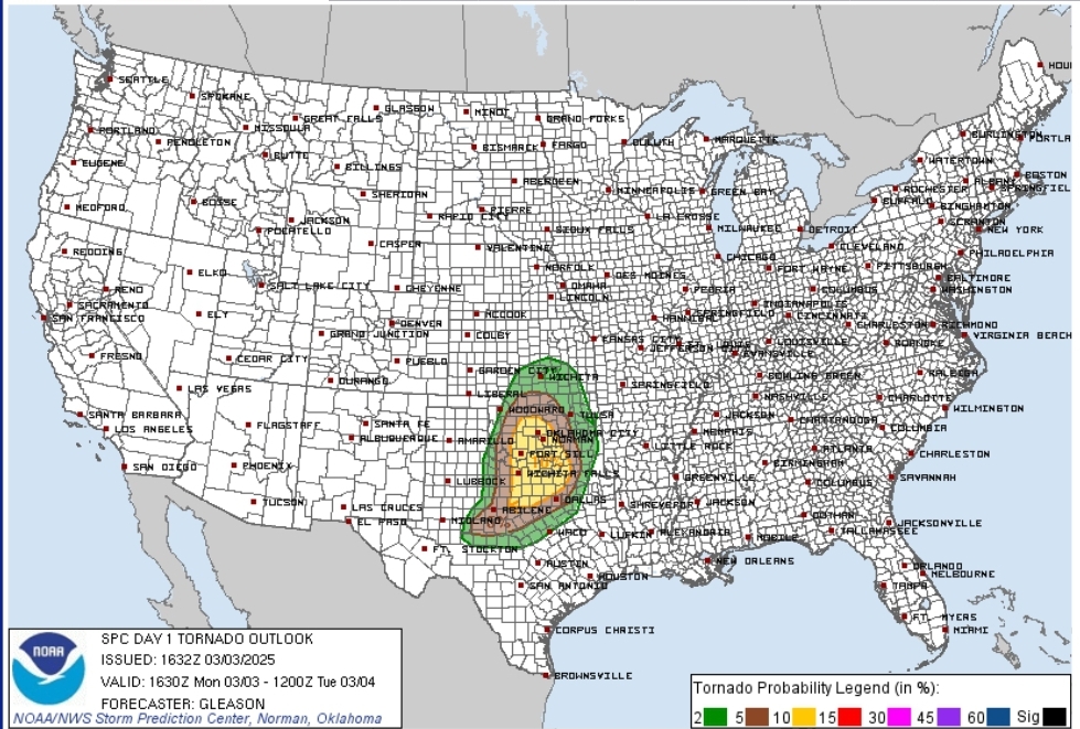
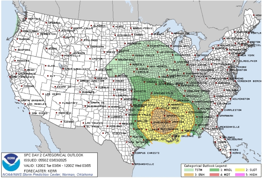
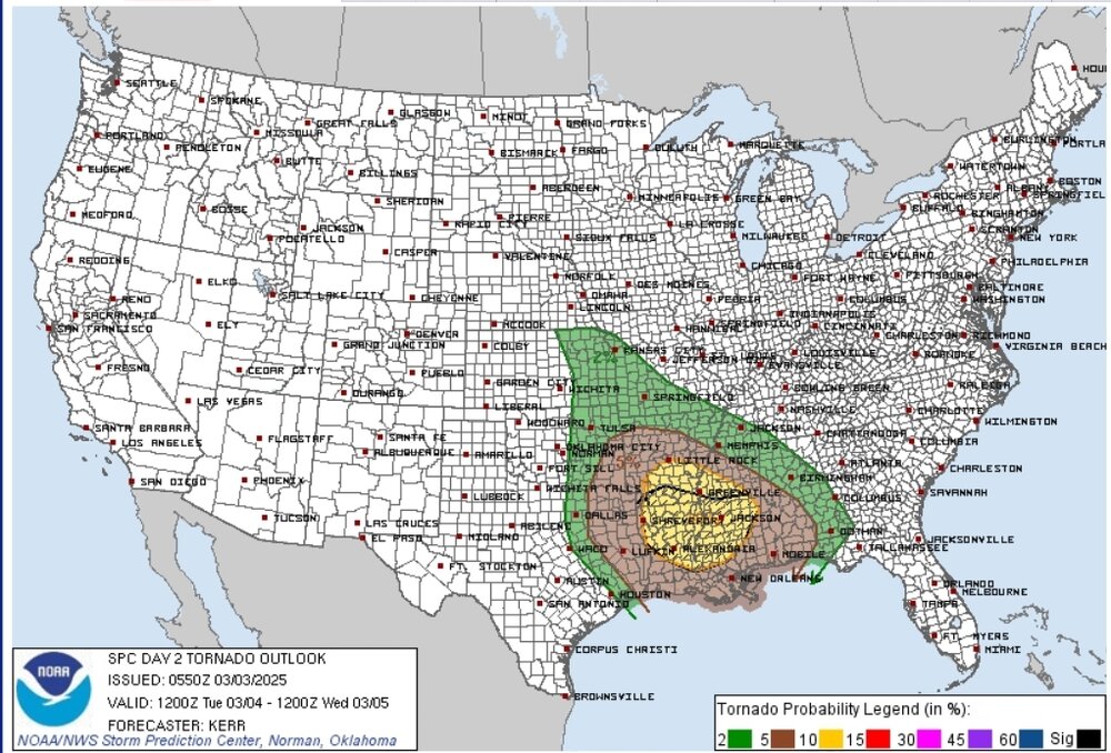
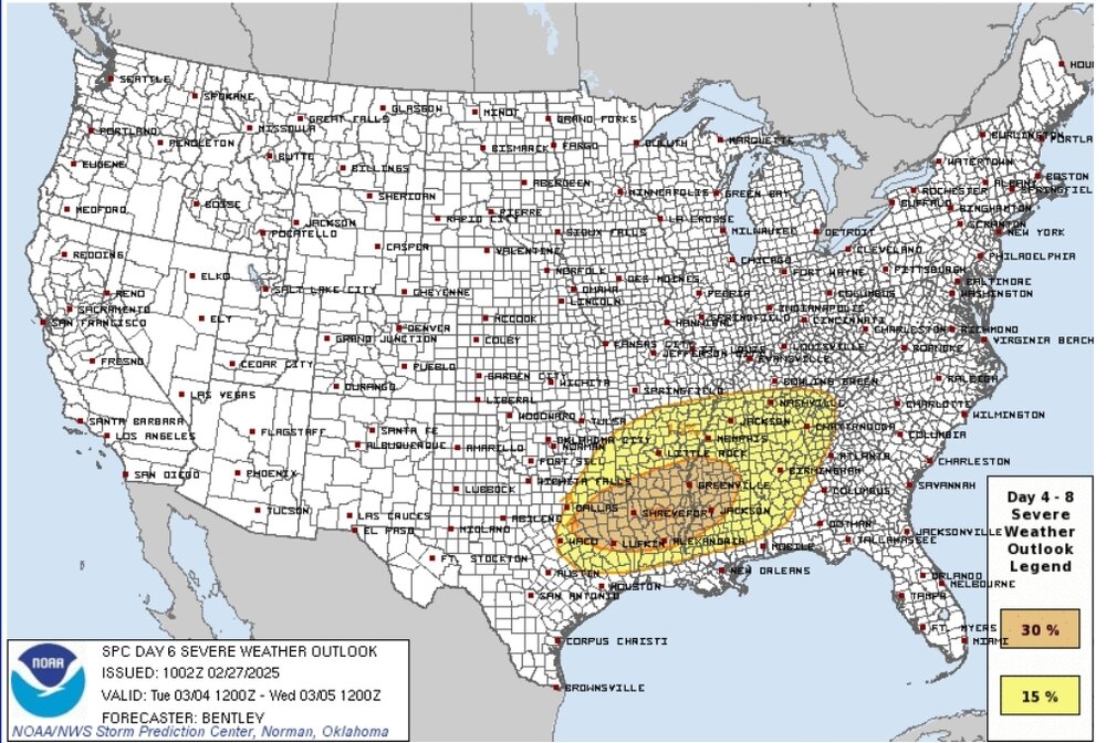
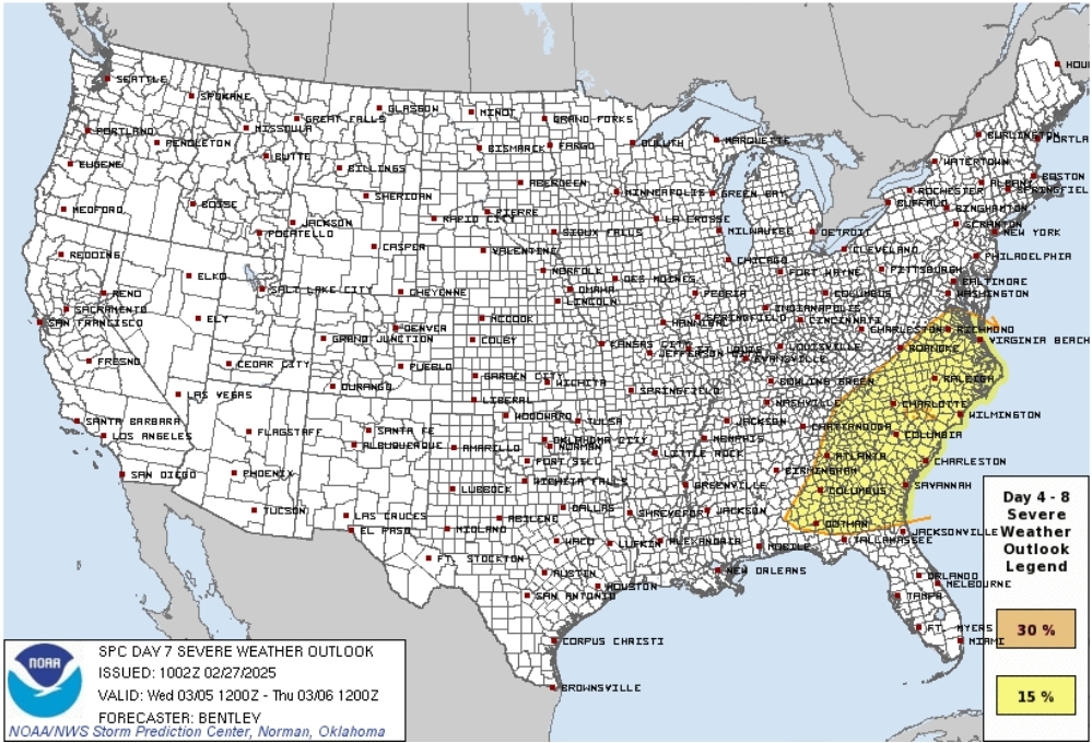
Surprise D1 ENH for today with 10% tor and tomorrow has had a 10% sigtor hatch added. Updated the thread again to reflect the dates more accurately
-
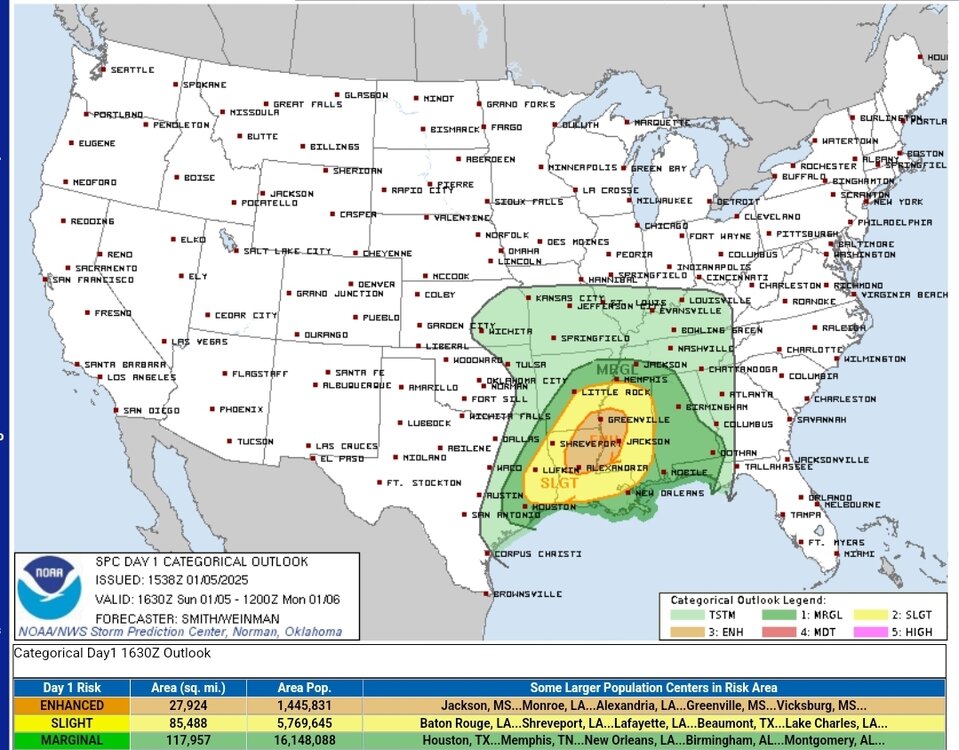
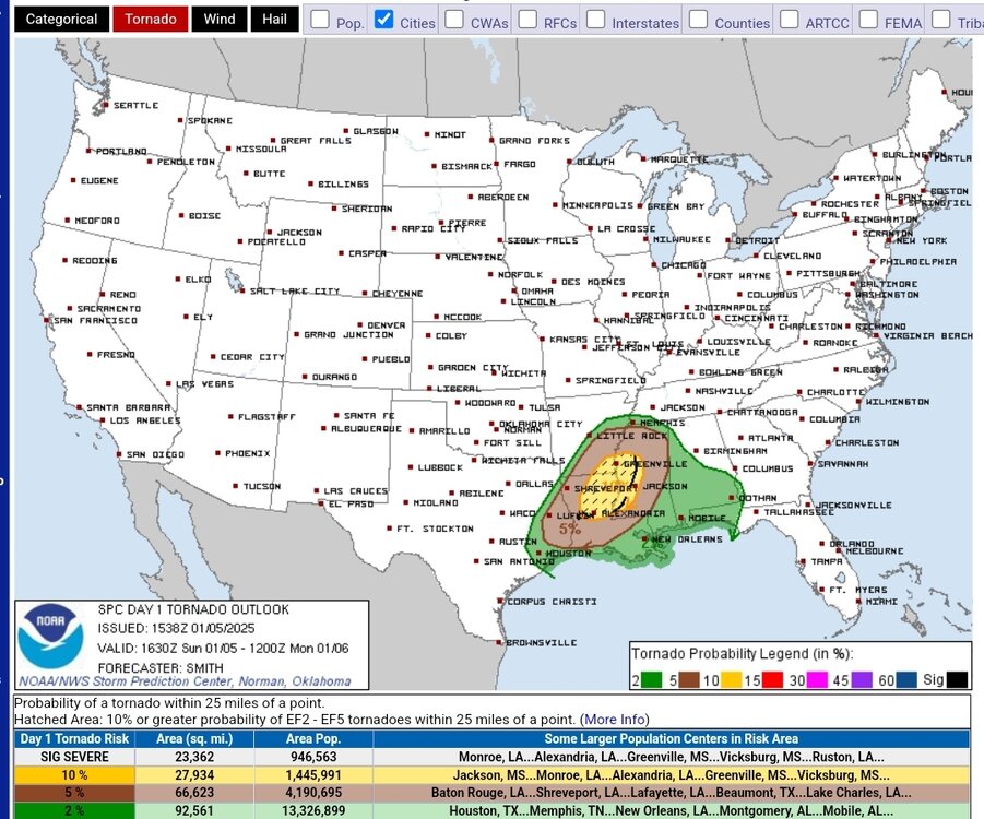
It's that time of year again! Looking like Tuesday may be a big day with the SPC already signaling strong tornado potential
-
Looking like we're getting our first shot at severw weather early this year!
-
Broken clocks and all that lol
-
It's Broyles tho who thinks every setup is the next "big one"
-
It sounds like consensus is putting this out of the "worst worst" case scenario (eye passing just north of Tampa bay) if taken verbatim? What kind of difference in surge can TB expect if it's south instead of north?
-
Those little wobbles are gonna make a huge difference for the Tampa bay area
-
And then there's the non-zero possibility of a second storm taking a similar path not too long from now...
-
https://www.cbs7.com/2024/06/03/one-person-injured-after-tornado-hits-sanderson/
-
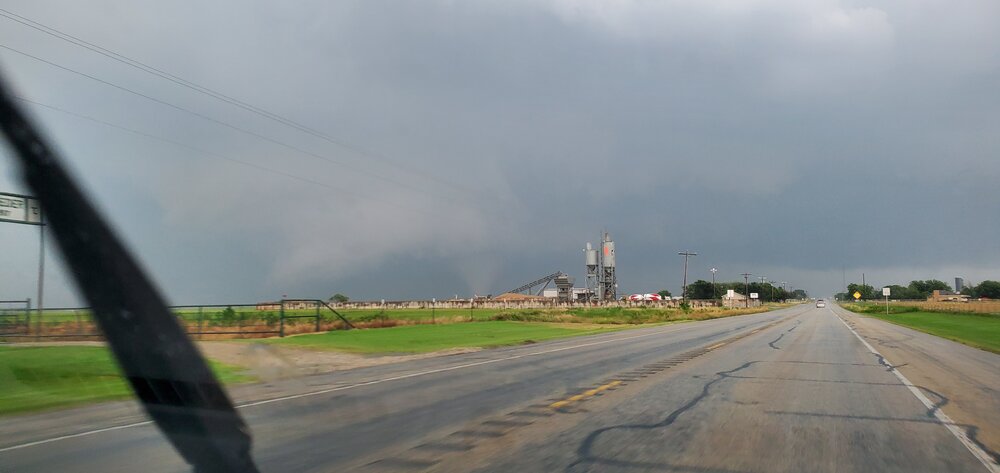
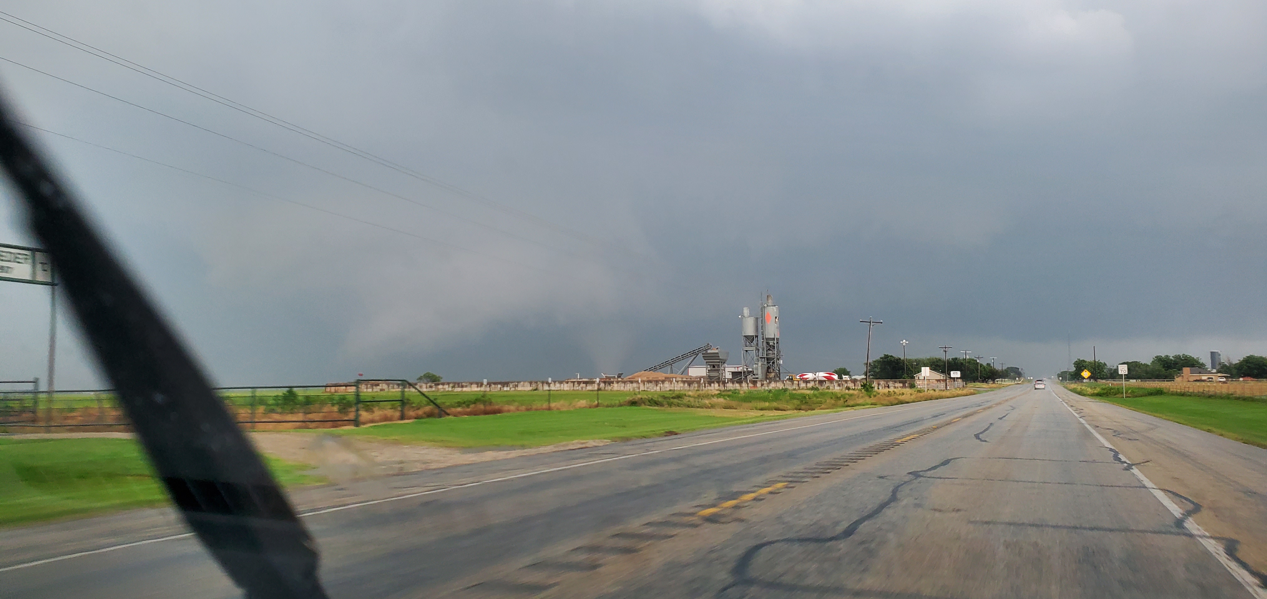
Managed to snag a pic of the Windthorst TX Tornado. Nothing crazy but my first time ever seeing a tornado IRL which was cool