All Activity
- Past hour
-

E PA/NJ/DE Summer 2026 Obs/Discussion
Chief83 replied to PhiEaglesfan712's topic in Philadelphia Region
Worcester, PA with a swing and a miss with a 0.05 for the day (Tuesday). -
The newer CMIP6 models place more importance on winter temps and the Atlantic front going forward. This year is a good example of that. Pretty good conditions present on the Pacific front, but the Atlantic front is weak enough to place the CAB near record lows with continental heat placing the CAA near record lows too. I keep expecting us to hit a wall here on extent (and we probably still will). However we may also get a decent late season run since there's still quite a bit of ice left to melt at lower latitudes in the Pacific. Regardless, I would not expect anything flashy until later next season or during the fall refreeze in '27. That's when big +ENSO tends to have an outsized effect.
-
 2 straight summers of webbed fists punching my nuts. Can’t wait for my 0.01”
-
Ticks are going to love this too. Ugh.
-
 I could see more of an argument if we were seeing something more anomalous like a barrage of like cutoff lows or something along the lines of a tendency for omega-block patterns (just using these as random examples) but this recent stretch of rains has been the product of slow moving frontal systems and warm front progression...kind of par of the course for mid-summer.
 -
That already happened up here, its right up there with the worst I've ever seen. Yesterday will only prolong that misery.
-
Mosquito explosion incoming?
-
 Inclined to agree with skepticism there. We have been dealing with this since last October... a basal trough that at times we see ridging, but we return to this footprint since prior to the ENSO switch onset. Most importantly, warm(cool) ENSO onset in summer isn't triggering much in the hemisphere. The hemispheric/seasonal cooling from N latitudes establishes improving gradient is autumn -that is when that forcing commences. To early.
 -

2026-2027 Super El Nino
40/70 Benchmark replied to Stormchaserchuck1's topic in Weather Forecasting and Discussion
I am getting a great deal of consensus from an early stage just like I did last season, which proved pretty damn accurate. My polar domain assessment should be ready hopefully before the weekend. It's taken a bit longer than I had hoped, which is par for the course if you're doing it right. -
 I'm fine with 4.5" here. No need for high water table/basement flooding issues.
 -
I had a very impressive ~3.75” July 12-15 at my place, which allowed me to stop irrigation for the time being. However, since then (~one week), I’ve had hardly any.
-
Certainly may see a few localized strong storms east of the river today
-
 5.16 on the month here. Much needed, could definitely use more though. Ponds and streams are low. Wonder what kind of deficit we are running year to date
 -

2026 Mid-Atlantic Severe Storm General Discussion
AlexD1990 replied to Kmlwx's topic in Mid Atlantic
any chance for today? -
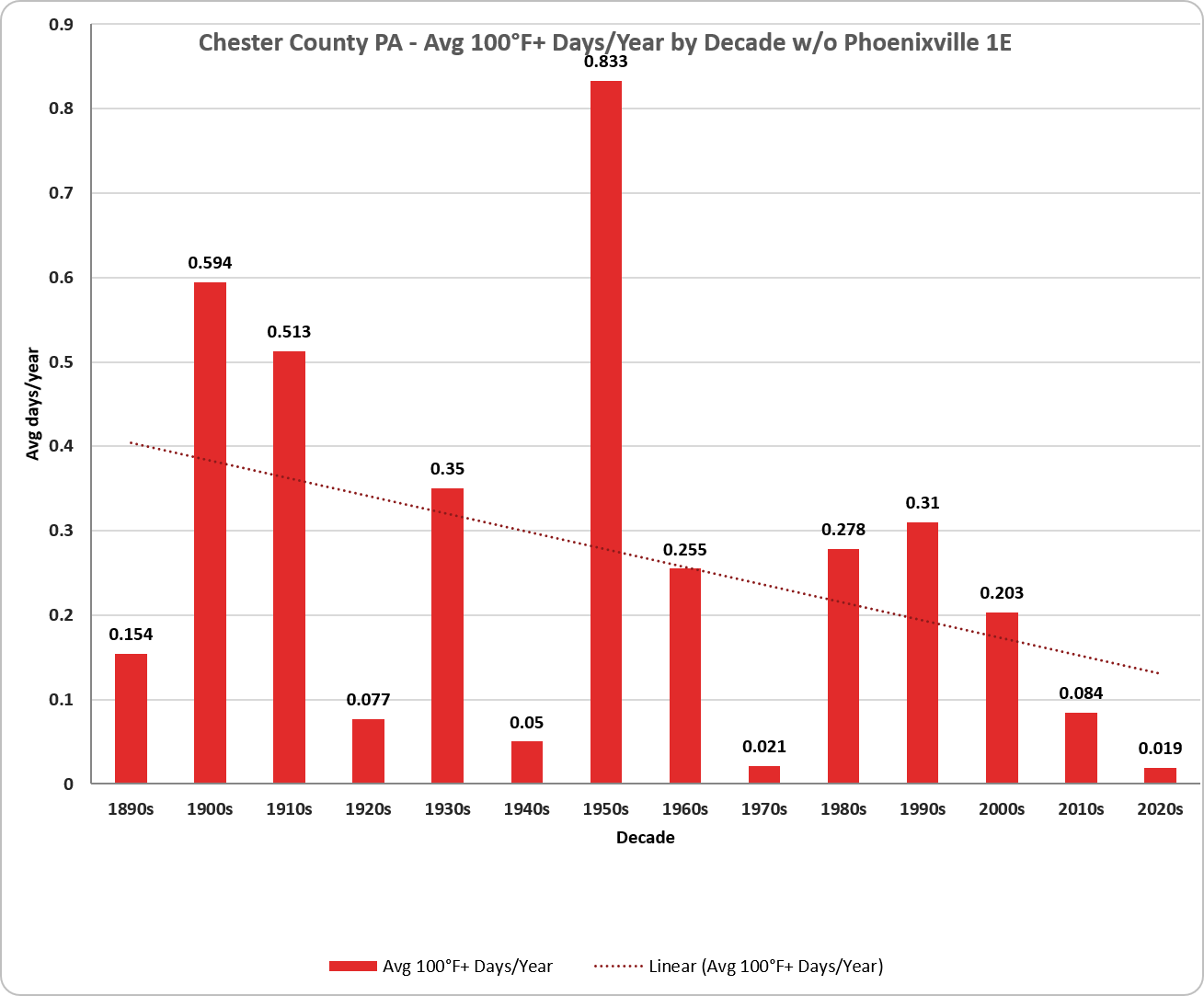
(002).thumb.png.6e3d9d46bca5fe41aab7a74871dd8af8.png) I also carved out Phoenixville in the 2nd chart based on concerns from @chubbs it's more urban location may skew the data. With or without Phoenixville the trend is clearly toward less 100 degree days in Chester County PA.
I also carved out Phoenixville in the 2nd chart based on concerns from @chubbs it's more urban location may skew the data. With or without Phoenixville the trend is clearly toward less 100 degree days in Chester County PA.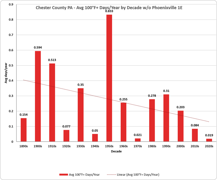
-
Not really sure how you can attribute this to ENSO. I mean there are just synoptic fronts moving through and getting heavy rains from the warm front and then scattered convection out ahead of the cold front. Unless there is an argument these are more common during summers with a developing EL Nino but these setups aren't uncommon during the summer months.
-
.86" in N. Bethesda
-
If these totals verify a lot of central and eastern NC may actually drop into DO and D1 drought categories next week. At my house we could easily be pushing a foot of rain for the month after this system
-
s tier nice day for sure, we deserve it
-
So nice to let fresh air in the house! Beautiful day. Very low humidity, 50s to start rising to the mid 70s.
-
Been a while since things were this green and this well watered at the mid point of Summer. Still some long term dryness going on but big improvements over NNJ last several weeks.
-
.46 last night and 1.60 for the month. Had a couple of flashes of lightning and a few rumbles of thunder.
-
That's a good appetizer, but for most we still need an entree.
-
@MANDA Chester is also wonderfully green for the second half of July.