All Activity
- Past hour
-
80% chance.
-
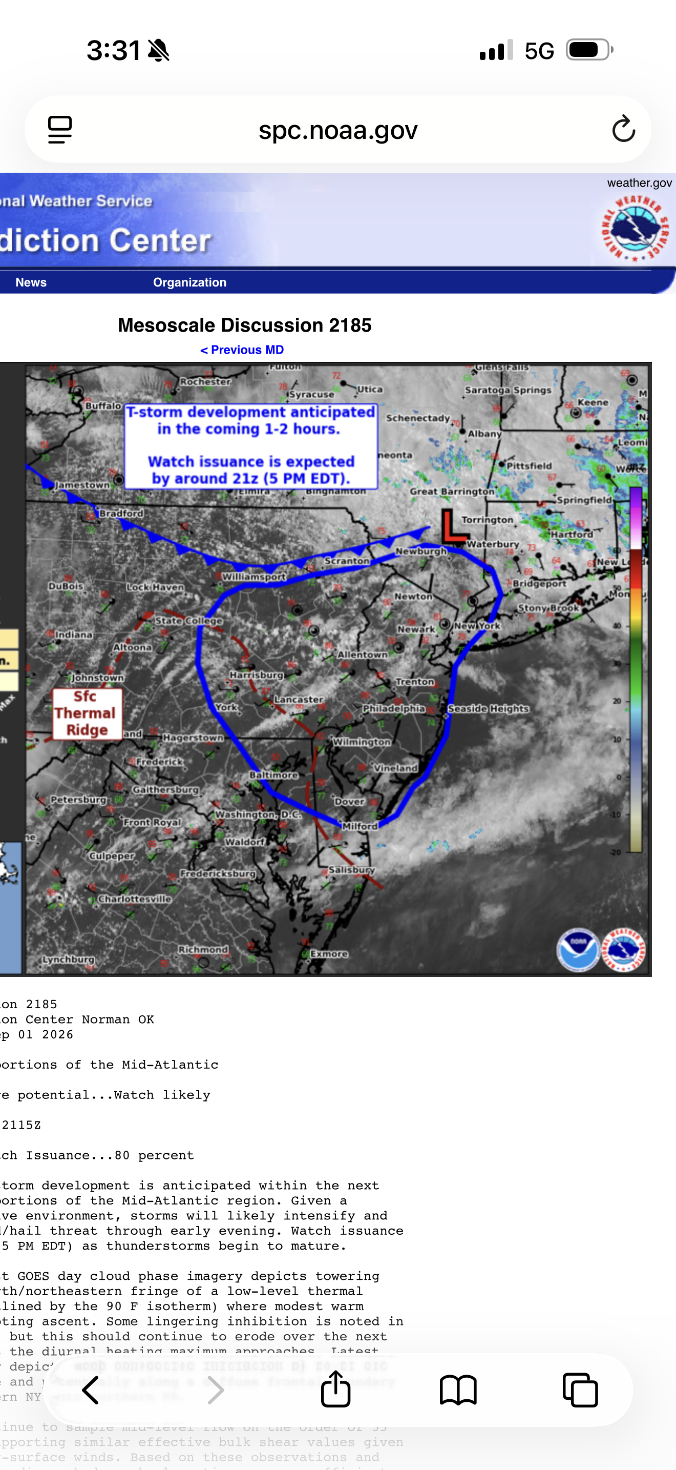
https://www.spc.noaa.gov/products/md/md2185.html Mesoscale Discussion 2185 NWS Storm Prediction Center Norman OK 0213 PM CDT Tue Sep 01 2026 Areas affected...portions of the Mid-Atlantic Concerning...Severe potential...Watch likely Valid 011913Z - 012115Z Probability of Watch Issuance...80 percent SUMMARY...Thunderstorm development is anticipated within the next 1-2 hours across portions of the Mid-Atlantic region. Given a favorable convective environment, storms will likely intensify and pose a severe wind/hail threat through early evening. Watch issuance is likely by 21z (5 PM EDT) as thunderstorms begin to mature. DISCUSSION...Latest GOES day cloud phase imagery depicts towering cumulus on the north/northeastern fringe of a low-level thermal ridge (roughly outlined by the 90 F isotherm) where modest warm advection is promoting ascent. Some lingering inhibition is noted in satellite imagery, but this should continue to erode over the next couple of hours as the diurnal heating maximum approaches. Latest guidance generally depicts deep convective initiation by 20-21 UTC within this regime and potentially along a diffuse frontal boundary draped from southern NY into northern PA. Regional VWPs continue to sample mid-level flow on the order of 35 knots, which is supporting similar effective bulk shear values given somewhat weak near-surface winds. Based on these observations and recent forecast soundings, hodograph elongation appears sufficient for organized convection, including the potential for a few supercells. While discrete modes persist, large hail (potentially up to 1.75 inches) will be possible. A brief tornado may also be possible - particularly across northern NJ/far southern NY near a weak surface trough where low-level veering may be adequate for a localized tornado threat. With time, clustering should promote some degree of upscale growth with an increasing severe wind threat, especially with southward extent into southern NJ and DE where guidance has been consistently showing a signal for clustered/linear storm modes. Given the favorable convective environment, watch issuance will likely be needed as convection begins to intensify. ..Moore/Gleason.. 09/01/2026 ...Please see www.spc.noaa.gov for graphic product... ATTN...WFO...OKX...ALY...PHI...BGM...CTP...LWX...
-
Mesoscale Discussion 2185 NWS Storm Prediction Center Norman OK 0213 PM CDT Tue Sep 01 2026 Areas affected...portions of the Mid-Atlantic Concerning...Severe potential...Watch likely Valid 011913Z - 012115Z Probability of Watch Issuance...80 percent SUMMARY...Thunderstorm development is anticipated within the next 1-2 hours across portions of the Mid-Atlantic region. Given a favorable convective environment, storms will likely intensify and pose a severe wind/hail threat through early evening. Watch issuance is likely by 21z (5 PM EDT) as thunderstorms begin to mature. DISCUSSION...Latest GOES day cloud phase imagery depicts towering cumulus on the north/northeastern fringe of a low-level thermal ridge (roughly outlined by the 90 F isotherm) where modest warm advection is promoting ascent. Some lingering inhibition is noted in satellite imagery, but this should continue to erode over the next couple of hours as the diurnal heating maximum approaches. Latest guidance generally depicts deep convective initiation by 20-21 UTC within this regime and potentially along a diffuse frontal boundary draped from southern NY into northern PA. Regional VWPs continue to sample mid-level flow on the order of 35 knots, which is supporting similar effective bulk shear values given somewhat weak near-surface winds. Based on these observations and recent forecast soundings, hodograph elongation appears sufficient for organized convection, including the potential for a few supercells. While discrete modes persist, large hail (potentially up to 1.75 inches) will be possible. A brief tornado may also be possible - particularly across northern NJ/far southern NY near a weak surface trough where low-level veering may be adequate for a localized tornado threat. With time, clustering should promote some degree of upscale growth with an increasing severe wind threat, especially with southward extent into southern NJ and DE where guidance has been consistently showing a signal for clustered/linear storm modes. Given the favorable convective environment, watch issuance will likely be needed as convection begins to intensify.
-
(002).thumb.png.6e3d9d46bca5fe41aab7a74871dd8af8.png)
Central PA Summer 2026 Discussion/Obs Thread
ChescoWx replied to Voyager's topic in Upstate New York/Pennsylvania
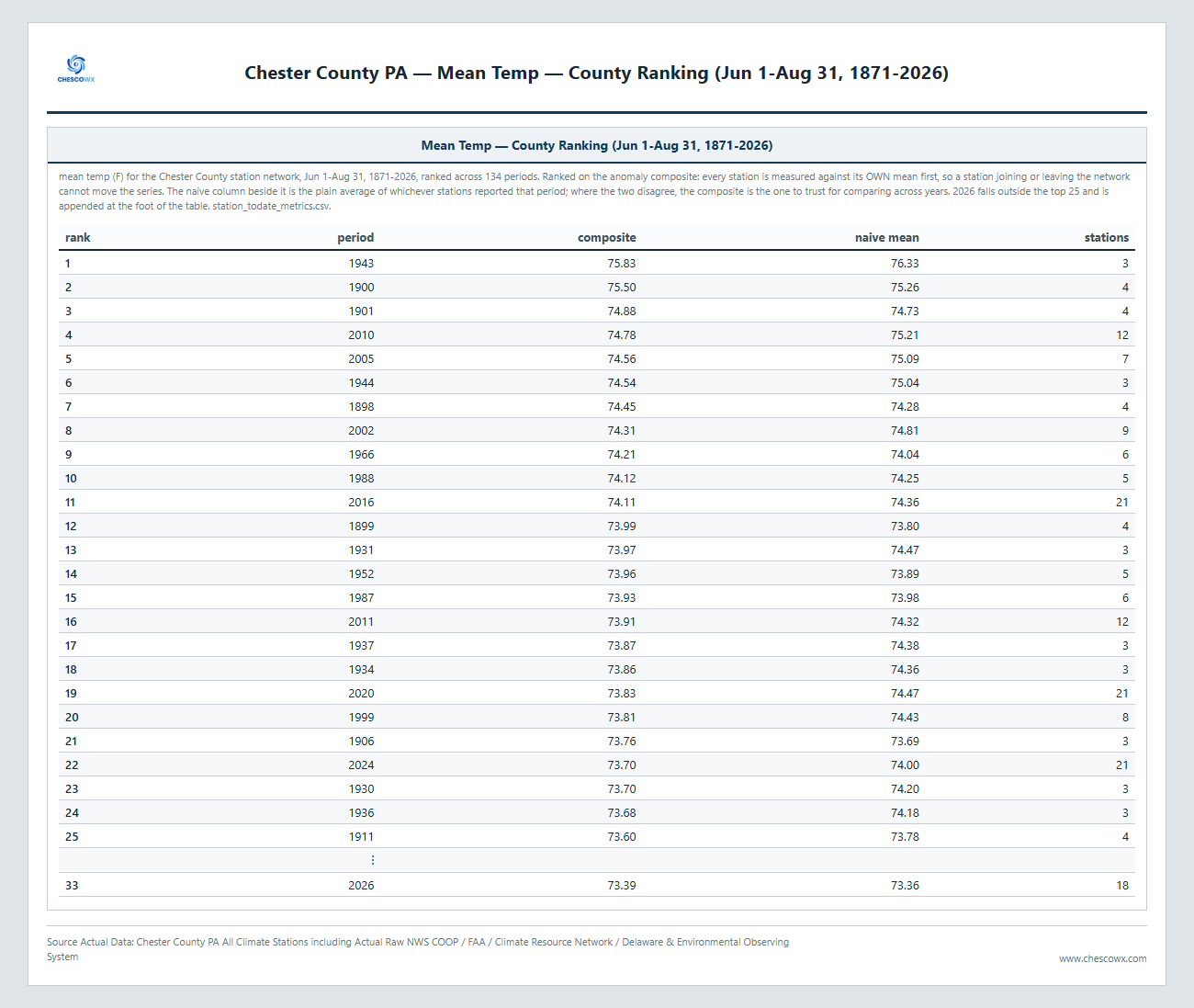
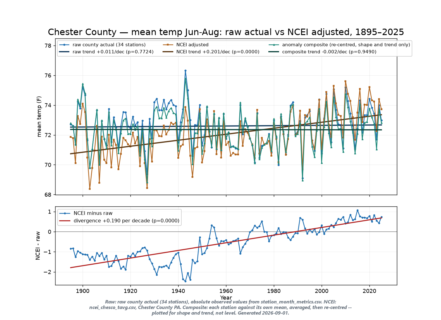
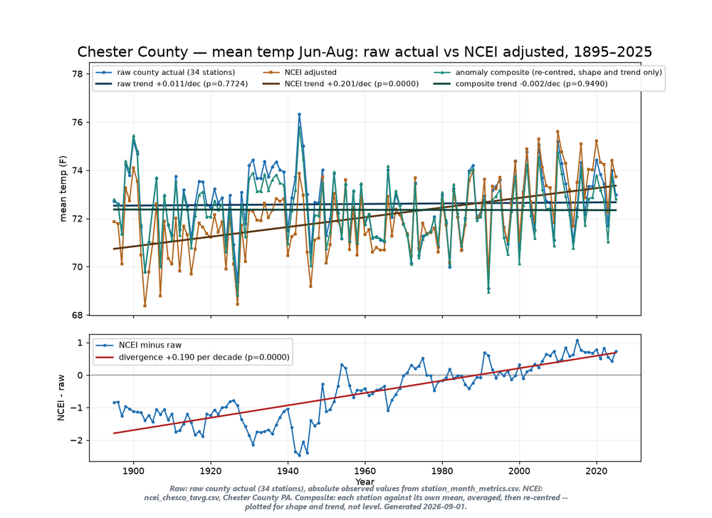
Below is the summer (June-July-August) temperature summary for 2026 and summer temperature history from 1871-1926. This was 33rd warmest summer but overall since 1895 there has been no statistically significant warming or cooling across both the raw and composite trend and only the NCEI adjusted averages indicate any significant summer warming.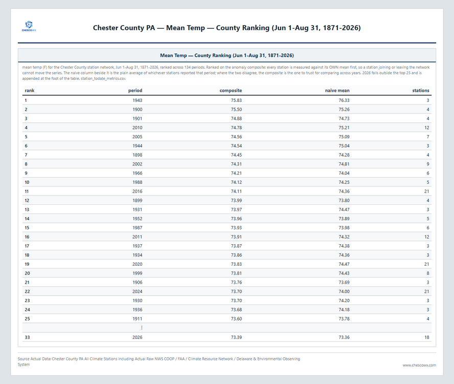
-
Alright how many times have my fellow Orioles fans watched the catch from last night? This may just win catch of the year. I mean the jump, the circumstances...might be hard to top that! Wow!
-
E PA/NJ/DE Summer 2026 Obs/Discussion
ChescoWx replied to PhiEaglesfan712's topic in Philadelphia Region
Below is the summer (June-July-August) temperature summary for 2026 and summer temperature history from 1871-1926. This was 33rd warmest summer but overall since 1895 there has been no statistically significant warming or cooling across both the raw and composite trend and only the NCEI adjusted averages indicate any significant summer warming.
-
000 WTNT65 KNHC 011925 TCUAT5 Tropical Storm Edouard Tropical Cyclone Update NWS National Hurricane Center Miami FL AL052026 225 PM CDT Tue Sep 01 2026 ...EDOUARD MAKES LANDFALL NEAR JOHNSON BAYOU, LOUISIANA... WSR-88D radar data from Lake Charles, Louisiana, and Houston, Texas, indicate that Edouard made landfall near Johnson Bayou, Louisiana, at 220 PM CDT (1920 UTC). Maximum sustained winds are estimated to be 60 mph (95 km/h). A National Ocean Service station near Texas Point, Texas, (TXPT2) recently reported a sustained wind of 57 mph (93 km/h) and a wind gust to 71 mph (114 km/h). SUMMARY OF 220 PM CDT...1920 UTC...INFORMATION ---------------------------------------------- LOCATION...29.7N 93.8W ABOUT 15 MI...25 KM SSE OF PORT ARTHUR TEXAS ABOUT 30 MI...50 KM WSW OF CAMERON LOUISIANA MAXIMUM SUSTAINED WINDS...60 MPH...95 KM/H PRESENT MOVEMENT...NW OR 305 DEGREES AT 8 MPH...13 KM/H MINIMUM CENTRAL PRESSURE...996 MB...29.41 INCHES $$ Forecaster Mahoney/Berg/Reinhart
-
 Let’s see how tomorrow night and Thursday can fail
 -
Agree for the morning and most of the Afternoon BUT there is a potential for the front to move back north as a warm front - timing is an issue right now - we have done quite well this summer regarding severe weather with warm fronts approaching from the south - time will tell..........
-
A meso discussion was issued in the last 15 minutes, watch looks likely by 5pm. I’m hoping it’s south of me.
-
Yeah I honestly didn't realize there was such a difference in the summer.
-

Winter 2026-2027 Speculation
Prismshine Productions replied to 40/70 Benchmark's topic in New England
I use Tapatalk Sent from my SM-S176V using Tapatalk -

Monday, August 31 - Thursday, September 3, 2026 Convective Episodes
weatherwiz replied to weatherwiz's topic in New England
Beautiful environment to our southwest...sigh. Well hopefully at least some good storms can fire across southern NY/PA/NJ...maybe even scrape Fairfield County -
Severe Thunderstorm Watch coming in an hour or two for NE MD and DE potentially per MCD
-
This weather sucks ass.
-
Port Arthur is ~10 miles inland and still well outside the core of tiny Edouard - not surprising winds haven't been very strong so far, but that could change soon. Texas Point (at Sabine Pass) on the coast at the border of TX/LA has recently seen sustained NNW winds to 50 kt with gusts to 59 kt. This is on the "weaker" western side of the storm. https://www.ndbc.noaa.gov/station_page.php?station=txpt2 On the eastern side, but a little outside the eyewall, around 12 PM CT Calcasieu Pass, LA saw sustained winds to 38 kt and gusts 45 kt. https://www.ndbc.noaa.gov/station_page.php?station=capl1
-
Now 46 gusting to 59 kts at Texas point, exceeding operational intensity. That’s a north wind coming off the land too. Higher velocities still offshore. To me this is easily a 55 kts system
-
No signs of a watch or meso discussion yet
-

Septorcher 2026 Discussion - Endless Summer
CoastalWx replied to Damage In Tolland's topic in New England
Go down the street and it’s pouring. Stein shaft over my house -
We still do not have an official landfall per the NHC, though it should be momentarily. Edouard's vortex has been stubbornly hugging the shoreline just ESE of Sabine Pass for quite a while now.
-

2026 Mid-Atlantic Severe Storm General Discussion
high risk replied to Kmlwx's topic in Mid Atlantic
One complication for tomorrow is that some of the guidance pushes a front from the northeast through the area later tonight. If that pushes well to our southwest like shown in the NAM Nest, we'll be cooler and more stable, at least on the Maryland side. Less aggressive guidance puts the boundary somewhere between DC and Baltimore and has it retreat later in the day. This would in theory be a focus for afternoon convection. -

Central PA Summer 2026 Discussion/Obs Thread
AccuChris replied to Voyager's topic in Upstate New York/Pennsylvania
91/76 here in Lebanon with a HI of 103 right now. Thermodynamic environment primed for explosion but will the fuse get lit later? Time will tell . -
This is why you hike starting early, particularly with high mountains of 13000-14000, and particularly when you know it's not going to be perfectly sunny. You try to get off the peak before lightning, which might even start going at 12:00-1:00. The earliest storms happen with the mid-day radiation. Thankfully I had many sunny days of hiking mountains, as I tried to plan it out that way.
-

2026-2027 Record-breaking El Nino
bluewave replied to Stormchaserchuck1's topic in Weather Forecasting and Discussion
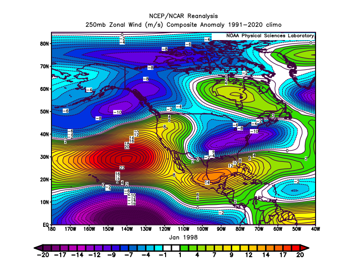
The east based nature went hand in hand with the overpowering STJ flooding North America with mild Pacific air. So even storms tracking south of the I-95 corridor were all rain near the coast. It was one of the rare cases of the STJ pumping the Eastern ridge in January causing it to link up with the Greenland block. Our recent link ups were mostly Northern Stream driven.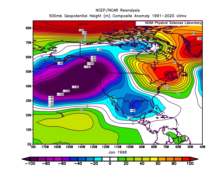
-
Not expecting much here-still mostly cloudy after an inch of rain