All Activity
- Past hour
-
Nice link, great info for the various stations. Bookmarked it for sure./ Thanks
-
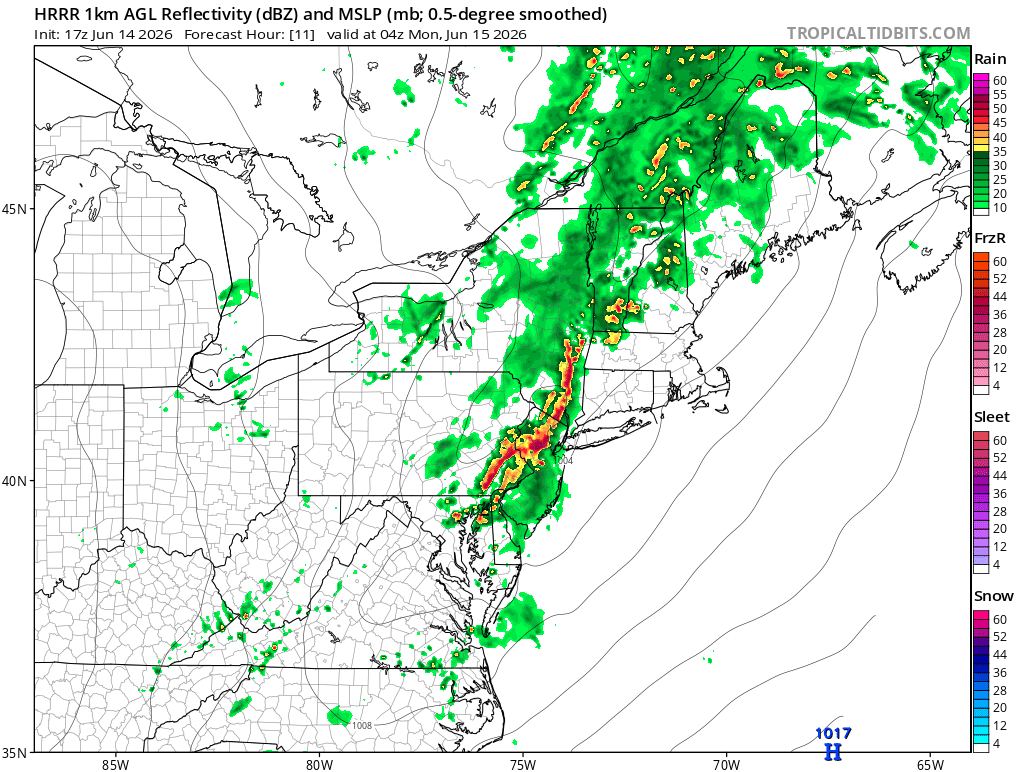
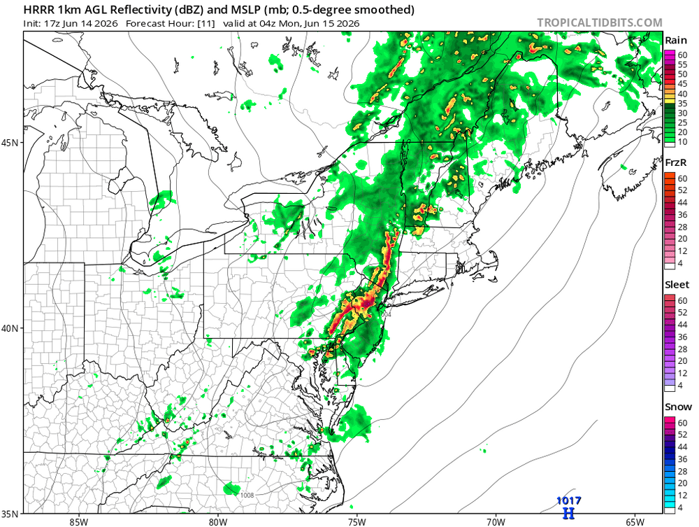
Looking like some pretty crazy dynamics later according to latest HRRR
-
MCD should be coming soon
-
The 12z Euro… holy moly.
-

Central PA Summer 2026 Discussion/Obs Thread
TheDreamTraveler replied to Voyager's topic in Upstate New York/Pennsylvania
I do always wonder when PA will see another outbreak like the May 1989 tornado outbreak. It's always a matter of when not if but it sure has been a long time since that's happened. I'm always in the camp of 'nothing ever happens' since that's usually how it is but eventually we'll get a day where that's not the case. -
This ended up being a 17 hour day. 5a out the door 7a warm up 8a shotgun start 145p shotgun start 445p rain delay 645p restart 8p done 10p home
-

2026-2027 Super El Nino
snowman19 replied to Stormchaserchuck1's topic in Weather Forecasting and Discussion
The PDO doesn’t force ENSO to do anything or prevent it from doing anything, it’s a completely separate extratropical entity. In fact, there are studies that show that ENSO events (especially strong ones) can influence/modulate the PDO if anything, not the other way around. Eric Webb has been arguing that the well coupled ++PMM (subtropical entity) is acting as a +PDO right now -
That cyclone encompassing the North Atlantic from Canada to Ireland is cool.
-
90 here as of 2PM. We could really use the rain as opposed to the wind later on.
-

2026-2027 Super El Nino
PhiEaglesfan712 replied to Stormchaserchuck1's topic in Weather Forecasting and Discussion
If the PDO doesn't turn positive, I think the el nino stays below +2C, and 94-95 is our best analog. PDO should flip if we get above +2C, and definitely if it's above +2.5C. There has never been a +2.5C el nino that had a -PDO. Definitely not the best winter, but we could get something out of one month (most likely February). -

2026 Mid-Atlantic Severe Storm General Discussion
SnowenOutThere replied to Kmlwx's topic in Mid Atlantic
Hmm, took a look at the mesoanalysis page and I’m still on the train of storms today could be nasty, but I have some concerns about initiation. I did a hand analysis of the SPC page and evidently the pre frontal axis is located along route 15. Meanwhile, the pre frontal trough associated with a low level wind shift from south to south west is draped across the Allegheny front. I’m just not sure we have the juice to kick off storms. My dew point is in the upper 60s, but our cape west of the beltway remains stubbornly in the 500-1000 range. This isn’t like last Friday where we had 3000+ Cape and near conditionally unstable LL lapse rates. Additionally, the RH between the LCL and LFC is 30-50% across where the trough would cause storms to form. Just seems we got a good bit stacked against us thermodynamically. That said, this is all beginner analysis so the Mets probably see reasons that storms will pop that I don’t. -
Another day with 90 percent rain and storms that's probably going to miss here again unless we get some miracle developments.
-
Maybe South east TN can get some storms later,cold front is still well out west but the Lapse rates and low level shear showing isnt that great later on,but there is convection that has recently popped up alomg the TN/MS line,guess we will see later.Wed looks to better as Jeff mentioned above,but even that the GFS fluctuates each run seemingly
-
We pour.
- Today
-
Multiple models are showing a large MCS traversing Iowa again the morning of the event. Will be interesting to see how the evolution of that affects the development later in the day. Very impressed by the synoptics of this. Powerful upper jet knifing in with very impressive shear profiles over a wide area on the nose of that.
-
I couldn't chase last Thursday due to being in Cleveland on a family trip (probably would have ended up on the still-tornadic relative junk in western IL anyway), but it'd be nice to have the target not be south of I-80 for once since I rarely can take PTO on short notice from my job.
-
Newark has reached 90° for the 12th time this year. The old record through June 14th was 10 days. That record was set in 1930 and tied in 1986 and 1991. 1930 finished with 37 90° or above days; 1986 had just 22; 1991 had 41.
-

2026 Mid-Atlantic Severe Storm General Discussion
high risk replied to Kmlwx's topic in Mid Atlantic
Yeah, the HRRR says that parts of our area will have dew points in the upper 50s within the next 2 hours, and I'm very skeptical of that. This is why the HRRR initiates convection later and further east. If it's wrong, storms should initiate somewhere along the Route 15 corridor. -
I will shoot rounds into the sky if this happens again here.
-

2026 Mid-Atlantic Severe Storm General Discussion
wxmeddler replied to Kmlwx's topic in Mid Atlantic
Definitely a plume across Central MD. Though it seems lower dews are just above the surface. The Layhill station recently gusted to 25 mph which coincided with a dew point drop to 63. Back up to 67 now.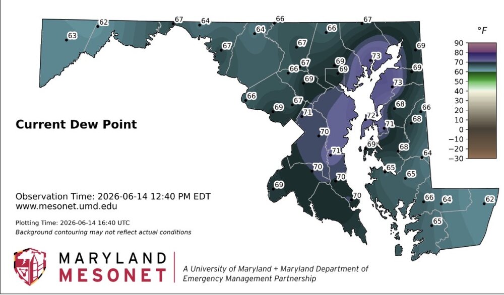
- 681 replies
-
- 1
-

-
- severe
- thunderstorms
- (and 7 more)
-
Both Marginal and slight got expanded way westward for today now in all of tn and north Georgia Alabama and Mississippi .
-
63F for SST’s off coast of NH https://www.ndbc.noaa.gov/station_page.php?station=44098 For the date that’s normal for south shore Long Island…
-
2026-2027 Super El Nino
snowman19 replied to Stormchaserchuck1's topic in Weather Forecasting and Discussion
-
UNH buoy east of NH already up to 63 degrees…. That’s a month ahead of schedule… https://www.ndbc.noaa.gov/station_page.php?station=44098
-
Looks to hold off til at least 9