
All Activity
- Past hour
-
I have had back and forth loud rumbles to howitzers since midnight. I'm seriously saying 1 or more a minute for the last 9 hours straight. I don't think I've ever had a lightning/thunder streak this long since I've lived here. Doesn't bother me at all normally but its really starting to get on my nerves now (my dog has 4mg's of xanax in him. He's gonna need a therapist). Rumble rumble rumble then bam. Even the rumbles are those far off explosive sounding strikes. Almost every blast of lightning is CG, no upper cloud stuff. Its freakin' nutz. The rain was pretty steady also, another 2.5in since last night bringing my 2 day total to 7. But just to my SSE they have been getting pummeled even worse, 4-7 inches overnight. The training over East Central/SE IN/SWOH is unreal. Every time I've checked the radar since this started around midnight they are just covered. If that next bow sustains and and doesn't swing to our south the ground is completely saturated primed and ready for tree falls with any wind. Once again, I hate these setups with a passion. Give me a single SUP with a TOR any day. Here and gone lol. This is like WWI trench warfare crap. Think I'm shell shocked lol
-
The one next year is really the one to see. If I had a million dollars I'd probably go to Gibraltar for it.
-
These would be perfect on some scrambled egg ice cream. Someone needs to invent that
-
4-6" with an immediate changeover to rain? I guess it would be payback for the February blizzard....
-
I ended up with 0.67 inch for the day. There may be another complex rolling through this afternoon/evening based on radar analysis upstream, but again, NWS doesn't seem to make much of it.
-

2026-2027 Record-breaking El Nino
michsnowfreak replied to Stormchaserchuck1's topic in Weather Forecasting and Discussion
All this concentration on Winter but Fall comes first. Fall is one of my favorite times of the year. October in MI is amazing so I'm hoping it is mostly dry, cool and sunny. -
makes u think^
-

Spring/Summer 2026 Pattern Discussion Thread
Mr Bob replied to Carvers Gap's topic in Tennessee Valley
Glad to see you got some good rains...we had some very small hail here in Hixson around dinner time but got about 0.5". Then another round at 11p.... -
Good quick explainer.
-
hate when that happens on the plus side, you'll get more chances, we haven't locked a rof pattern in like this in a long time
-

Spring/Summer 2026 Pattern Discussion Thread
dwagner88 replied to Carvers Gap's topic in Tennessee Valley
Got over 2" from a very vivid storm last night. Lots of trees down this morning. -
Everything is missing me this month. A line of big storms blew up just west of Cedar Rapids this morning and it certainly looked like we would be hit, but the first cell sagged south and then the rest of them followed. A band of 2-3" fell barely south of CR and I only got 0.11".
-
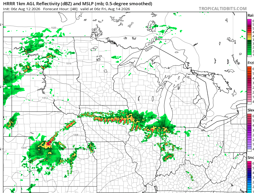
liked the llj storms at the end of this hrrr run
-
Records: Highs: EWR: 98 (2021) NYC: 97 (1944) LGA: 98 (2021) JFK: 92 (1970) Lows: EWR: 54 (1954) NYC: 55 (1889) LGA: 56 (1979) JFK: 55 (1979) Historical: 1752 - The following is from the Journals of the Rev. Thomas Smith, and the Rev. Samuel Deane, published in 1849. In the evening there was dismal thunder and lightning, and abundance of rain, and such a hurricane as was never the like in these parts of the world. This hurricane struck Portland, 1752: Portland, Maine: “It blew down houses and barns, trees, corn and everything in its way. Such a hurricane as was never the like in these parts of the world” — Rev. Thomas Smith (Ref. WxDoctor) Maine. 1778 - A Rhode Island hurricane prevented an impending British-French sea battle, and caused extensive damage over southeast New England. (David Ludlum) 1901: Three inches of rain fell in 40 minutes during the morning at Rancocas, NJ. A similar event occurred in the same region 99 years later. (Ref. Wilson Wx. History) 1910: Electrical storms ignited numerous forest fires in the Bitterroot Mountains of Idaho. Entire towns were burned and 163 people died, including 78 firefighters. (Ref. AccWeather Weather History) 1933 - The temperature at Greenland Ranch in Death Valley, CA, hit 127 degrees to establish a U.S. record for the month of August. (The Weather Channel) 1936 - The temperature at Seymour, TX, hit 120 degrees to establish a state record. (The Weather Channel) 1936: The temperature at Seymour, TX hit 120° to establish a state record. Altus tied the Oklahoma state temperature record by reaching 120°. The high of 109° tied the record high for the month of August at Dodge City, KS. From the 12th through the 24th, there was a record 13 days on which temperatures reached 100° or more at St. Louis, MO. (Ref. The Weather Channel) (Ref. WxDoctor) 1955 - During the second week of August hurricanes Connie and Diane produced as much as 19 inches of rain in the northeastern U.S. forcing rivers from Virginia to Massachusetts into a high flood. Westfield MA was deluged with 18.15 inches of rain in 24 hours, and at Woonsocket RI the Blackstone River swelled from seventy feet in width to a mile and a half. Connecticut and the Delaware Valley were hardest hit. Total damage in New England was 800 million dollars, and flooding claimed 187 lives. (David Ludlum) 1955: The greatest DAILY precipitation to occur in the month of August or any month in Richmond, Virginia was 8.79 inches from Hurricane Connie. (Ref. Richmond International Airport Records) 1982: Sparta, WI recorded their coldest August temperature with 32°. This is also their earliest freezing temperature. La Crosse, WI set a record low with 46 °F.: (Ref. Wilson Wx. History) 1985: The "New Lisbon Tornado" F2 tornado set down south of Kendall, WI, destroying a barn and damaging a home before moving northeast into Juneau County. The tornado moved from the countryside into New Lisbon, ripping through a trailer court on the northern edge of town before dissipating on the north edge of Castle Rock Lake. A couple was killed and 22 others were injured in Juneau County. Numerous trees and power lines were downed, including 100 acres of forest at Buckhorn State Park. Over $620,000 in damage occurred. (Ref. Wilson Wx. History) 1987 - Early afternoon thunderstorms in Arizona produced 3.90 inches of rain in ninety minutes at Walnut National Monument (located east of Flagstaff), along with three inches of pea size hail, which had to be plowed off the roads. (The National Weather Summary) (Storm Data) 1988 - Fifteen cities in the northeastern U.S. reported record high temperatures for the date. Youngstown OH reported twenty-six days of 90 degree weather for the year, a total equal to that for the entire decade of the 1970s. (The National Weather Summary) 1989 - Thunderstorms were scattered across nearly every state in the Union by late in the day. Thunderstorms produced wind gusts to 75 mph at Fergus Falls MN, and golf ball size hail and wind gusts to 60 mph at Black Creek WI. In the Chicago area, seven persons at a forest preserve in North Riverside were injured by lightning. (The National Weather Summary) (Storm Data) 1993: The Great Mississippi River Flood continued as flood waters flowing past Tarbert Landing, , MS reached 832,000 cubic feet per second, which is nearly 4 times the normal August flow. (Ref. AccWeather Weather History) 1999: Severe thunderstorms developed in west central Illinois during the early evening, and moved to the Indiana border during the next several hours. Winds gusting over 80 mph caused over $50 million dollars in crop damage to Schuyler, Mason, Menard, Logan, Cass, Morgan and Scott Counties. Miles of power lines were blown down in Cass County, and numerous trees were damaged through the area. (Ref. Wilson Wx. History) 2000: Three inches of rain fell in 40 minutes during the morning at Rancocas, NJ. A similar event occurred in the same region 99 years before. (Ref. Wilson Wx. History) 2001: An Amelia County, VA man was struck and injured by lightning in his home after lightning hit a porch railing and jumped to the door he had been holding. (Ref. Lightning - Virginia Weather History) Overnight rains up to 8.4 inches in Sussex County, Delaware led to failure of a dam on Hearns Pond during the early morning. Historic Hearns and Rawlings Mills were heavily damaged, along with roads and buildings, with damage at $1.1 million dollars.(Ref. Wilson Wx. History) 2004: Hurricane Charley was the third named storm and the second hurricane of the 2004 Atlantic hurricane season. Charley lasted from August 9 to August 15, and at its peak intensity, it attained 150 mph winds, making it a strong Category 4 hurricane on the Saffir-Simpson Hurricane Scale. It made landfall in southwestern Florida at maximum strength, making it the most powerful hurricane to hit the United States since Hurricane Andrew struck Florida in 1992. 2004: Bonnie made landfall as a 45 mph (72 km/h) tropical storm just south of Apalachicola, Florida on August 12. It accelerated northeastward, and became a remnant area of low pressure on August 14 to the southeast of New Jersey. 2005 - A tornado strikes Wright, Wyoming, a coal-mining community, killing two and destroying 91 homes and damaging about 30 more in around the town. 2016: August 9-16. Weak low pressure combined with abundant Gulf moisture produced phenomenal rainfall and flooding across central Louisiana, inundating entire neighborhoods and towns, especially around Lafayette and Baton Rouge. Rainfall totals exceeded 20 inches in as little as two days. Thirteen people died and economic costs ranged from $10 to $15 billion.
-

Occasional Thoughts on Climate Change
Typhoon Tip replied to donsutherland1's topic in Climate Change
One thing I wanna do when I have the free time - which I never do - is find the actual geophysically applied science to/and resulting publication(s) regarding the supposed feedbacks between the earth surface and air during the Dust Bowl era. In blunt, simple terms, I always thought that was dubious - but sort of covet that opinion more so until I see how exactly those that claim farming practices/methodology of land management can couple en masse to the extent that it causes an entire continental -scaled consequence. mmm okay. I can understand feedbacks, but that would be in part. I am suspicious of the idea that land management was the primary driver of haboob phenomenon. There are also two distinct aspects that I think folks also conflate - at least in the general discussion that seems to be suggested to me. Dust storms and heat can by mutually exclusively originating. Yes, heat aids in evaporation... so a relationship is quite obviously there. But it is also not required. Example, Gobi desert spring dust storm climo; these events are triggered by the "Mongolian Cyclone" sending strong cold winds. These events are just as bad... significantly impacting air quality and visibility in just the same exact way. I'm preeeetty sure there is no farming practices in the Gobi desert lending to creating a vast heat dome in the late winter and springtime there. Ya think If all that skepticism (and sarcasm!) is true, then that logically urges that whatever pattern synergistically aroused big heat response in 1936 was actually not holistically caused by land-air feedback as a primary mechanism. There likely was feedback modulation going on... Bad land management certainly contributed to the dust side of the discussion. But there may have been resonance in the hemisphere lending to a multi-seasonal 'pattern fractal'; a super-synoptic origin forcing a leitmotif that favored heat and drought, then undermined by bad land management. These decadal fractal in synoptic biases happen throughout history. I really feel like I need to see the wholesale science on the matter to gain an understanding of how much 'improper land management practices led to the dust storm' vs how much of that may have also just been a dry antecedent decadal signal then exacerbating dusty consequence. As far as the heat, as a Meteorologist, that starts over eastern Asia with planetary wave transmitting wave orientation across the Pacific, ultimately favoring(not favoring) a long-wave resonance over North America. All of which is preface to an idea ... that should such a resonance recur during this latter accelerating base-line trend ... I wonder what the extremes would layout like. -
75 / DP: 61 clear with clouds clinging to the southern half of the region into SNJ. Enough sun and the hotter places could get to 90 otherwise upper 80s max. Pretty much a 3 peat Wed-Thu-Fri before drier cooler air comes in Sat and most of Sunday although Sunday - Monday could trend warmer with the ridge to our west flexing but it looks to coincide with the next front and chance for showers/storms. The period 8/17 - 8/20 near normal then overall warmer beyond there with hints the western ridge builds heat and links with the southeast ridge with a window of some heat coming this way 8/21 - 8/25 period. Tropics pickingup but most look Atlantic formed and bound.
-

Spring/Summer 2026 Pattern Discussion Thread
John1122 replied to Carvers Gap's topic in Tennessee Valley
I'm getting a pre-storm ahead of the line of storms sweeping south. -
I slept through it but woke up to 1.55” for the day.
-
 http://mexisaferx.com/# mexico prescriptions
 - Today
-
Sunday has a chance according to CSU
-
DVN just gusted to 59mph. Should be another very nice soaker en route.
-

Augdewst 2026: Summer's Last Stand
dendrite replied to Prismshine Productions's topic in New England
Gotta love BOS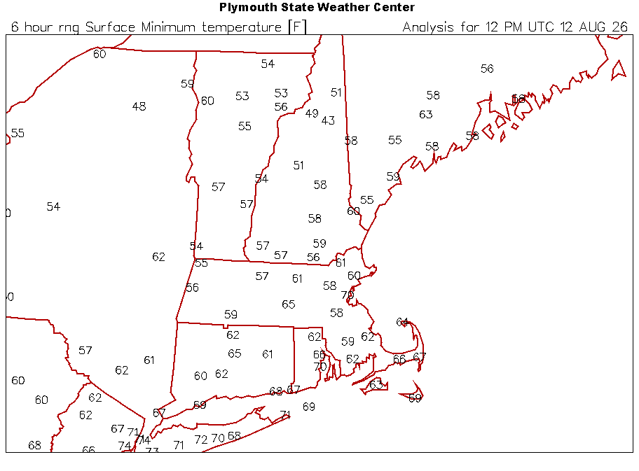
-

2026 C and E Pacific tropical activity
Kevin Reilly replied to GaWx's topic in Tropical Headquarters
My friend's plane leaves for Honolulu Hawaii Friday, August 14th. He is taking a Hawaiian island cruise around all the islands. Looks like the GFS has a 985 mb storm and the Euro 997 mb storm making a direct hit on the big island before moving west and away. Looks like this system is a legitimate threat to Hawaii. Any updates from the more seasoned tropical guys here would be great. I am able to see the models and the water vapor maps / satellites etc. looks like a bit of shear and dry air to the north limiting development for now. Looks like the legitimate threat lies at 11 N and 143 W if I am looking at it correctly but almost looks like another up there at 15N and 139 W. It looks very active out there. -
Occasional Thoughts on Climate Change
Typhoon Tip replied to donsutherland1's topic in Climate Change
Btw, Europe is quickly closing on a JJA warmest ever for a second consecutive year. I'm not sure if that's on whole, or in lesser quadratures but just a-priori on the story-line to date proooobably implicates everywhere? I dunno on that per se. interesting tho -

2026-2027 Record-breaking El Nino
jconsor replied to Stormchaserchuck1's topic in Weather Forecasting and Discussion
You can find VP anomaly from 1940s to present from JMA 3Q reanalysis here: https://ds.data.jma.go.jp/gmd/tcc/tcc/products/clisys/figures/db_hist_jun_tcc.html (10 day means) https://ds.data.jma.go.jp/gmd/tcc/tcc/products/clisys/figures/db_hist_mon_tcc.html (monthly means) In the menu on upper left under "Field", click on Tropics. Then under Element, click 200 hPa Velocity Potential.
















