All Activity
- Past hour
-
Good call
-

2026-2027 Strong/Super El Nino
A-L-E-K replied to Stormchaserchuck1's topic in Weather Forecasting and Discussion
-

2026 Mid-Atlantic Severe Storm General Discussion
dailylurker replied to Kmlwx's topic in Mid Atlantic
Oops. Had it backwards. I'm hugging the NAM lol. I'm just glad we now have a discussion about it. LFG! -

Central PA Spring 2026 Discussion/Obs Thread
pawatch replied to Voyager's topic in Upstate New York/Pennsylvania
Be interesting to see how close the new Euro is. -
blah blah blah.. !
-
He’s baaaaack
-
Everybody wants social media(anll the different forms) and memes and AI….these are the consequences to such things.
-

2026-2027 Strong/Super El Nino
bluewave replied to Stormchaserchuck1's topic in Weather Forecasting and Discussion
Definitely more of a La Niña flavor with the forcing moving from the IO into the WPAC. Places like Manchester, New Hampshire tied their all-time May high temperature. So a first for such a strong developing El Niño. You will notice how the previous years occurred during developing La Niña summers after El Niño winters. Plus following La Niña winters continuing into the next year. Earlier in May was more of Nino-like pattern with a stronger +PNA and trough in the East. So a continuation of mixed influences with the developing super El Niño and record warm pool from the IO to WPAC. Long range models missed this record warm up and tropical convection moving from the IO into WPAC leading to a very strong Southeast ridge. Time Series Summary for Manchester Area, NH (ThreadEx) - Month of May Highest Maximum Temperature Click column heading to sort ascending, click again to sort descending. 1 2026 97 Developing Super El Niño - 2010 97 Developing La Niña 2 1941 96 Multiyear Strong El Niño start in 1940 3 2022 95 Multiyear La Nina 4 2021 94 Multiyear La Niña - 2017 94 Multiyear La Nina - 2016 94 Developing La Nina - 2013 94 Neutral - 2007 94 Developing La Niña - 1889 94 Developing La Niña 5 2024 93 Developing La Niña - 2018 93 Uncoupled El Niño after La Niña -

2026 Mid-Atlantic Severe Storm General Discussion
high risk replied to Kmlwx's topic in Mid Atlantic
Big downdraft CAPE is our path to severe today, because the shear sucks. That might be enough to get it done in a few corridors where storms organize, but this would have had some legit widespread material had we achieved better winds aloft. -
We weren’t supposed to get much yesterday and we got drenched. I don’t trust the modeling in these.
-
Drier. Not rain free but not 3 days of rain and 40’s like it’s been showing
-
2026 Mid-Atlantic Severe Storm General Discussion
high risk replied to Kmlwx's topic in Mid Atlantic
The overnight NAMs are lit up like Christmas trees. It's the HRRR that wants to keep all activity today focused north of DC. -
Tough forecast for some areas with that sharp rain cutoff. Still crappy everywhere but dry would be more tolerable than an all day stratiform rain.
-
Sharp cutoff just to the NE of NYC for the weekend rains
-

2026-2027 Strong/Super El Nino
LakePaste25 replied to Stormchaserchuck1's topic in Weather Forecasting and Discussion
If you’re talking the difference between 97-98 and 15-16, I don’t think it matters as much as one might think it does in terms of winter prospects. 97-98 could’ve easily had a mid atlantic KU blizzard just like 82-83, 15-16 did. Maybe 15-16 had more cold periods, but that’s it. The reason we prefer a 97-98 outcome is because it will eradicate the W pac warm pool. -
Was pretty gross leaving gym at 7am this morning.
-
Its a holiday weekend so it will probably verify.
-
(002).thumb.png.6e3d9d46bca5fe41aab7a74871dd8af8.png)
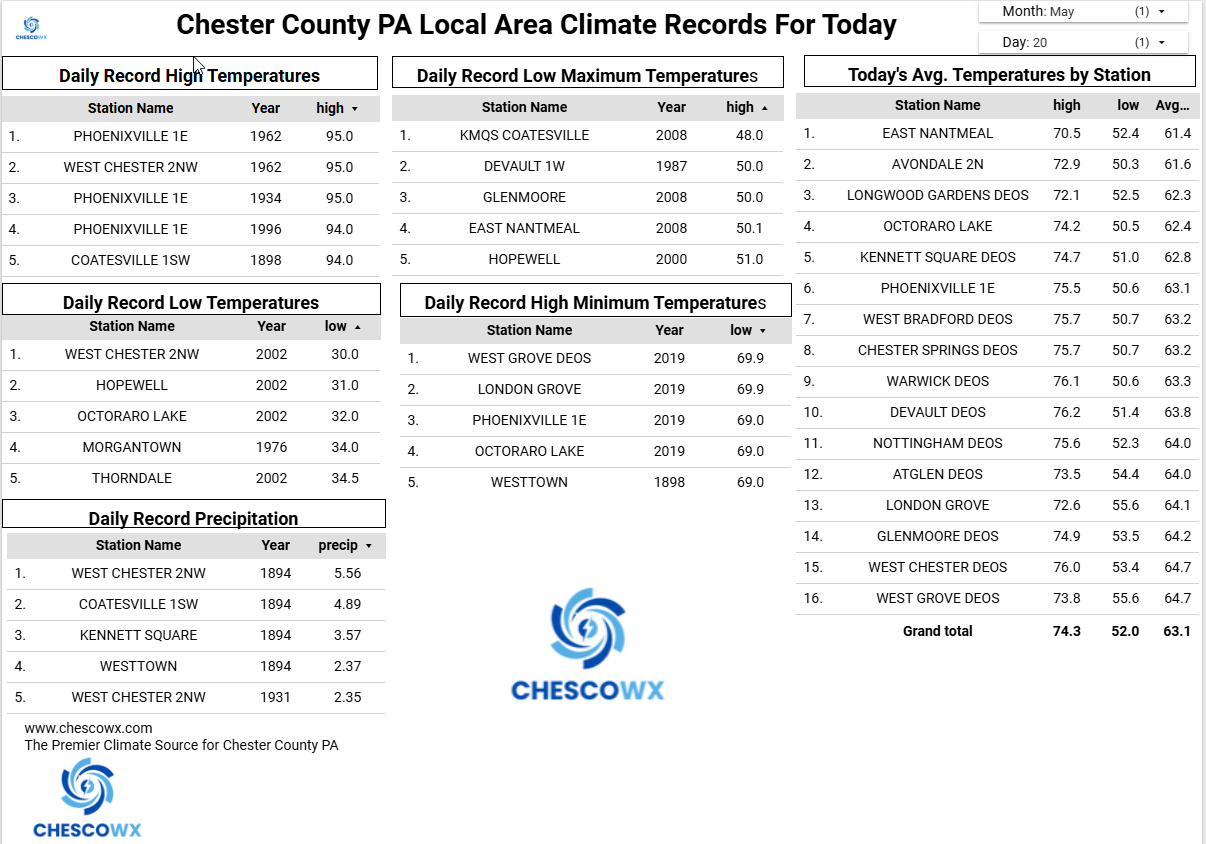
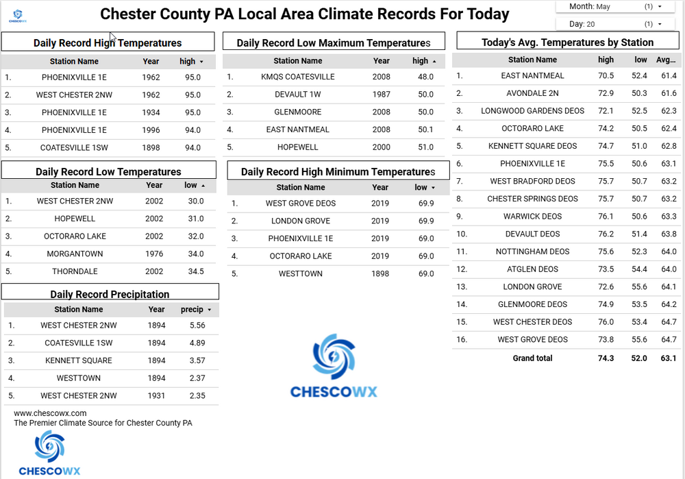
Central PA Spring 2026 Discussion/Obs Thread
ChescoWx replied to Voyager's topic in Upstate New York/Pennsylvania
Who is ready for some weather whiplash? After one more unseasonably warm day today we flip to unseasonably chilly starting tomorrow and lasting through at least Sunday. Tomorrow's afternoon temperatures are likely to be more than 30 degrees chillier than today with widespread 50's. We turn even chillier by Saturday with some models hinting at record low maximum temperatures with highs struggling to escape the cold 40's during the afternoon. Some much-needed rain looks to arrive later today and continue off and on through tomorrow. More steady rain arrives Friday night and continues through Saturday. This combination of rain and cold will make Saturday feel more like a raw early March day than Memorial Day Weekend.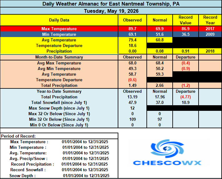
-
E PA/NJ/DE Spring 2026 Obs/Discussion
ChescoWx replied to PhiEaglesfan712's topic in Philadelphia Region
Who is ready for some weather whiplash? After one more unseasonably warm day today we flip to unseasonably chilly starting tomorrow and lasting through at least Sunday. Tomorrow's afternoon temperatures are likely to be more than 30 degrees chillier than today with widespread 50's. We turn even chillier by Saturday with some models hinting at record low maximum temperatures with highs struggling to escape the cold 40's during the afternoon. Some much-needed rain looks to arrive later today and continue off and on through tomorrow. More steady rain arrives Friday night and continues through Saturday. This combination of rain and cold will make Saturday feel more like a raw early March day than Memorial Day Weekend.
-

2026-2027 Strong/Super El Nino
George001 replied to Stormchaserchuck1's topic in Weather Forecasting and Discussion
So I’m curious why you guys think this El Niño is expected to grow so powerful not too long after our last strong event in 2023-2024. The latest guidance has this hitting high end strong at a minimum, given how this event has been developing (already near +1C on the daily in Nino 3.4, subsurface is boiling etc) that seems conservative if anything. The return rate for super ninos is what, once every 8 or so years? My thoughts are this developing super nino is a response to the persistent and intense La Niña background state we have been in (delayed oscillation effect, I know Ray has mentioned this idea in his blogs several times over the years). I was thinking in March that the super Nino idea might not pan out because we just had a strong event in 23-24, but perhaps that “la nino” was a strong El Niño inside a persistent Nina background state, and this is the real regime changing El Niño (that will compare to previous more traditional super El Niños rather than a La Nino)? I have to say, we don’t see eye to eye often but I have to agree with Adam about how this event is developing. He struggled last winter, but he has been on point about this early developing El Niño. It’s more basinwide than east based right now, but I don’t think it really matters in terms of winter prospects. If he’s right about the strength, the warmth will be everywhere (as is standard in super ninos), and it likely will leak more east anyways like 97-98 because super ninos tend to do that historically. I know there has been some pushback on that analog, but no analogs are perfect. 97-98 is good enough at a high level. My top analogs right now are 97-98, 15-16, and 82-83. -
Low of 39 at the airport. There was patchy frost at my suburban office.
-
2026 Mid-Atlantic Severe Storm General Discussion
dailylurker replied to Kmlwx's topic in Mid Atlantic
I'm hugging the HRRR. For the record I feel like today we have a good shot at something fun. At this point I'd be pumped to see some lightning and downpours. -
Without looking at anything, and in the absence of any context whatsoever, I will venture out on a limb and guess you are thinking warmer than forecast?
-
Yep, the environmental impacts of that will be mind-boggling.
- Today
-
First +90 temp of the year at 90.2 degrees for a high, not a record (95 in 1996), low and current 58.7 degrees.