All Activity
- Past hour
-
Well, here we go again. URGENT - WINTER WEATHER MESSAGE National Weather Service Duluth MN 1254 PM CDT Wed Mar 11 2026 MNZ020-021-121100- /O.NEW.KDLH.BZ.W.0002.260312T1800Z-260313T1800Z/ Southern Lake-Southern Cook- Including the cities of Silver Bay, Two Harbors, and Grand Marais 1254 PM CDT Wed Mar 11 2026 ...BLIZZARD WARNING IN EFFECT FROM 1 PM THURSDAY TO 1 PM CDT FRIDAY... * WHAT...Blizzard conditions expected. Total snow accumulations between 6 and 13 inches. Winds gusting as high as 45 mph. * WHERE...Southern Cook and Southern Lake Counties. This includes the Tribal Lands of the Grand Portage Reservation. * WHEN...From 1 PM Thursday to 1 PM CDT Friday. * IMPACTS...Visibilities will drop below 1/4 mile due to falling and blowing snow. The strong winds and weight of snow on tree limbs may down power lines and could cause sporadic power outages. Whiteout conditions are expected and will make travel treacherous and potentially life-threatening. The hazardous conditions will impact the Thursday evening and Friday morning commutes. * ADDITIONAL DETAILS...Snowfall rates will be intense, possibly exceeding 2" per hour Thursday evening.
-
Heat is on here. AC in Tolland?
-

E PA/NJ/DE Spring 2026 Obs/Discussion
LVLion77 replied to PhiEaglesfan712's topic in Philadelphia Region
Heavy rain and rumbles of thunder. Pretty neat for March. -
90 at 3:59pm.
-

E PA/NJ/DE Spring 2026 Obs/Discussion
RedSky replied to PhiEaglesfan712's topic in Philadelphia Region
Flashing sky its about to hit at 8pm -

2026 Mid-Atlantic Severe Storm General Discussion
wxmeddler replied to Kmlwx's topic in Mid Atlantic
Holy cow, did you ever figure out the polarity and amperage? -
.thumb.jpg.6a4895b2a43f87359e4e7d04a6fa0d14.jpg)
Central PA Spring 2026 Discussion/Obs Thread
Yardstickgozinya replied to Voyager's topic in Upstate New York/Pennsylvania
Me too. My aunt lives up near him and is reporting some pretty extensive tree damage. She's in her eighties, so I didn't ask her to go out and take any pictures for her me. -
Easy come Easy go
-

E PA/NJ/DE Spring 2026 Obs/Discussion
CoolHandMike replied to PhiEaglesfan712's topic in Philadelphia Region
.34" from the first storm cell in like 5 minutes. Nice to see an early spring storm I guess. -

2026 Mid-Atlantic Severe Storm General Discussion
AmericanWxFreak replied to Kmlwx's topic in Mid Atlantic
Collapse with entrapment in Marriotsville down the road from me -

-
Miss for the most part in northern McLean. Some rumbles of thunder and a quick shower. No heavy rain or high winds either.
-
Hardly any lightning. Some heavy rain sure. But bust! We can’t even do severe warned storms here anymore. Worst winter ever.
-
Euro?
-
Havent even had a chance to go this year. Is that the Toe?
-
Two years ago we were hit by a direct strike and it caused $70k of damage to our house. It is incredible how the perspective changes once that has happened. .
- 121 replies
-
- 4
-

-

-

-

-
- severe
- thunderstorms
- (and 7 more)
-
A little wind in Pikesville, Power flickered a few times. Nothing crazy
-
Drove to my brother's in Mass today it was 57, back home in Maine its 37.
-
Central PA Spring 2026 Discussion/Obs Thread
Yardstickgozinya replied to Voyager's topic in Upstate New York/Pennsylvania
Really amazing picture regardless. That's not to far from me. I wish I could have been that close. -
Models are not showing anything in the mid to long range but I also think we get 1 more snow event .
-
Coating tomorrow on cold surfaces
-

2026 Mid-Atlantic Severe Storm General Discussion
MN Transplant replied to Kmlwx's topic in Mid Atlantic
Ah connective season. That means a trace of rain and thunder somewhere in the distance.- 121 replies
-
- 1
-
-
- severe
- thunderstorms
- (and 7 more)
-
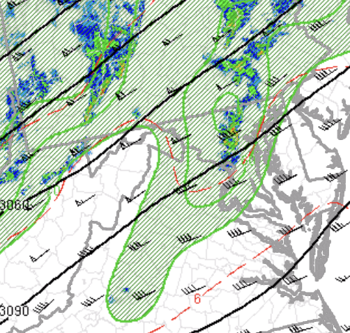
This event is very driven by 700mb forcing. Local maxima NW of Baltimore, where the most severe storming is, and much less flow with southern extent, which is causing the southern side of the storm to be much weaker. Our temp/dew spreads are a little wider down here as well, which is not helping matters.
- 121 replies
-
- 1
-

-
- severe
- thunderstorms
- (and 7 more)
-

Central PA Spring 2026 Discussion/Obs Thread
canderson replied to Voyager's topic in Upstate New York/Pennsylvania
581 W after the split - she was running an errand instead of driving straight home -
Nice gusty shower in progress. My wife saw a lightning strike in the distance as it approached, but no T&L that I can hear or see with the rain.