All Activity
- Past hour
-

2026 Mid-Atlantic Severe Storm General Discussion
Eskimo Joe replied to Kmlwx's topic in Mid Atlantic
You mean June 1, 2012? The moderate risk day that almost went full gang busters? -
With so many of the 12z western ROABs missing, I wonder if it's going to be a summer of short term model guidance beating mid range?
-
No doubt. I was a little hopeful, but am slowly learning to basically ignore any rain threats coming from the NW. They simply don't make it past the Yadkin river.
-
Had another half inch of rain fall too. Grass and flowers are looking better.
-
Didn't even know it rained up at home while at work or at work. Building is so quiet. Did watch storms blow up over point pleasant on our bridge cams. North bergen got flooded. Never seen it on this side of north bergen along Hudson. https://www.threads.com/@amprincipe/post/DZgsviGEWZ5?xmt=AQG0Yuy2QCZhP2PHwK3F_-vf2Hh6JEmkiXjZgD4kSB6pCIdjNk-wOsPK-n0PC4zJj8fnsm2N&slof=1
-

2026 Mid-Atlantic Severe Storm General Discussion
high risk replied to Kmlwx's topic in Mid Atlantic
June 1, 2011 also comes to mind when looking at this setup. You're absolutely correct that a Day 6 outlook for this part of the country is a rare thing, and there certainly is high end potential. Verbatim, I think that the overnight solutions would really favor New England for the greatest potential, but we'll see how the synoptic evolve over the next few days. -

E PA/NJ/DE Summer 2026 Obs/Discussion
LVblizzard replied to PhiEaglesfan712's topic in Philadelphia Region
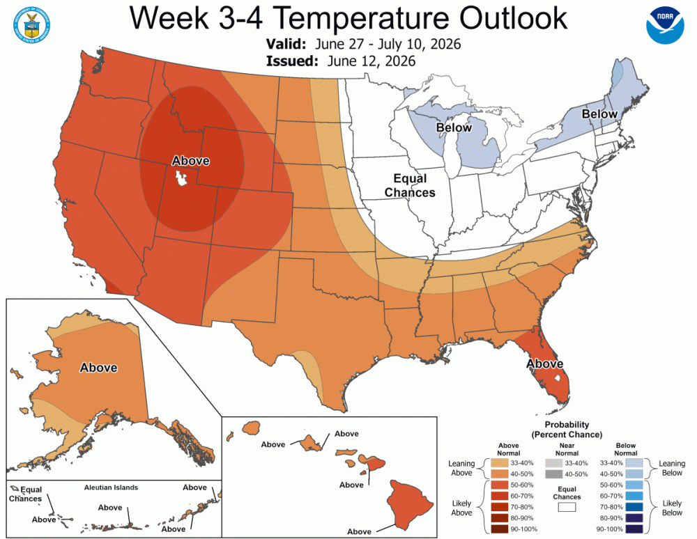
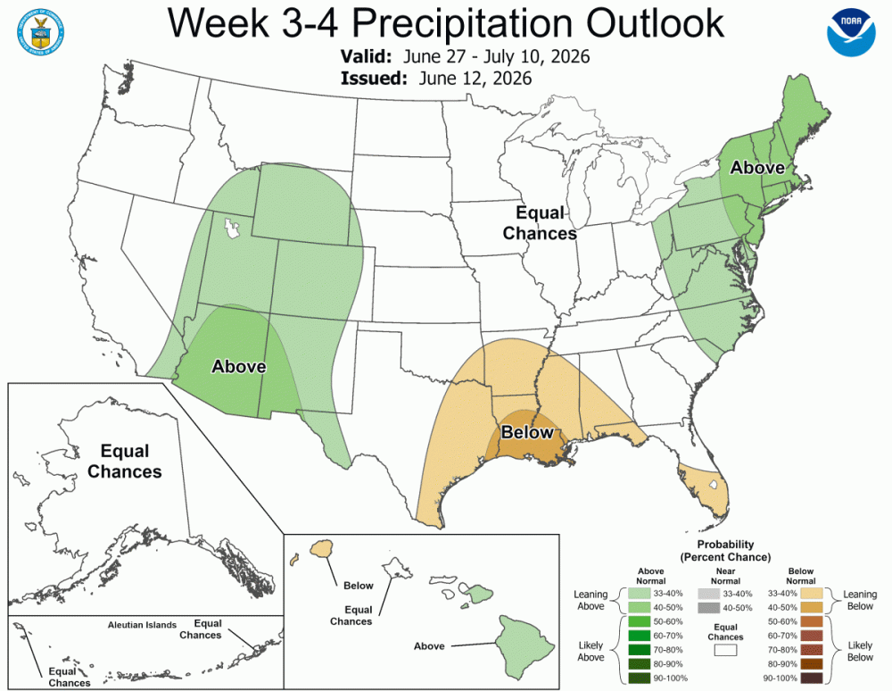
SPC put out a somewhat rare day 6 15% area for PA/NJ. Would be really nice to get a severe day sandwiched in between all these cool, low humidity days. -
Awesome day out there. 81 and a fresh breeze….perfect summer day.
-
Outside of the Canadian suite, midday mesos say to enjoy your drought
-

2026-2027 Super El Nino
snowman19 replied to Stormchaserchuck1's topic in Weather Forecasting and Discussion
The WPAC DWKW looks real healthy now….. -
(002).thumb.png.6e3d9d46bca5fe41aab7a74871dd8af8.png) So I asked AI who is the best source of weather / climate data for Chester County PA? Can AI be wrong??
So I asked AI who is the best source of weather / climate data for Chester County PA? Can AI be wrong??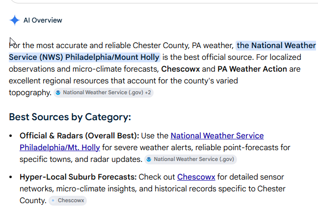
-
Thank goodness it didn't hit your house! A few years ago a guy down the street had something similar - it was an easily 100ft tulip tree that was field-grown so it was just massive, in the middle of his yard. Storm blew it right over and the spread of the root ball was taller than his single story ranch home. For some stupid reason he had it all cut up. I would have at least let the root ball remain as it was so huge.
-
As I mentioned when I started this thread, we will see this off n on throughout the summer.
- Today
-

Summer 2026 Med/Long Range Discussion
BeastFromTheEast replied to Brian D's topic in Lakes/Ohio Valley


-
Amen on pollen!
-
78/57… beautiful outside for yard work.
-

Central PA Summer 2026 Discussion/Obs Thread
canderson replied to Voyager's topic in Upstate New York/Pennsylvania
Thankfully for the less humidity! I don’t love tomorrow’s setup. -
Central PA Summer 2026 Discussion/Obs Thread
ChescoWx replied to Voyager's topic in Upstate New York/Pennsylvania
Several degrees cooler today and much less humid. Highs will still be several degrees above normal levels. Much more humid again tomorrow before a strong cold front crosses the area tomorrow night. We should see temperatures falling back below normal both Monday and Tuesday before we warm up again toward the end of the week. Shower chances increase tomorrow afternoon into the evening with the cold front.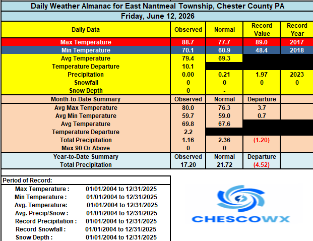

-
E PA/NJ/DE Summer 2026 Obs/Discussion
ChescoWx replied to PhiEaglesfan712's topic in Philadelphia Region
Several degrees cooler today and much less humid. Highs will still be several degrees above normal levels. Much more humid again tomorrow before a strong cold front crosses the area tomorrow night. We should see temperatures falling back below normal both Monday and Tuesday before we warm up again toward the end of the week. Shower chances increase tomorrow afternoon into the evening with the cold front.
-
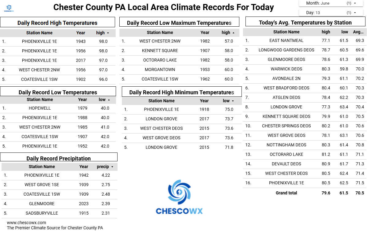
0.21” of rain last evening. This wetter stretch combined with slightly below average temperatures has been great to temper the drought worries . 9.98” of precipitation since January 1st. Almost at double digits!
-

2026 Mid-Atlantic Severe Storm General Discussion
GramaxRefugee replied to Kmlwx's topic in Mid Atlantic
Dog's vet office on Crownsville Rd sent a text this morning that they still don't have power and several trees are blocking access. Can't open today. -
June 13 1991: One fatality and 5 injuries occur when lightning strikes a tree at Hazeltine Golf Course during the US Open. 1930: A tornado hits the Northfield area, and causes heavy damage at Randolph. For Saturday, June 13, 2026 1889 - Forest fires in northern Wisconsin and northeast Minnesota were in the process of destroying millions of dollars of board feet of timber. (David Ludlum) 1907 - The temperature at Tamarack, CA, dipped to 2 degrees above zero, the lowest reading of record for June for the U.S. The high that day was 30 degrees. Tamarack received 42 inches of snow between the 10th and the 13th. On the 13th the snow depth was 130 inches. (The Weather Channel) 1984 - Severe thunderstorms struck Denver deluging the city with five inches of rain, and leaving up to six feet of water in some places. Softball size hail smashed windshields and ripped through metal cars. Snow plows had to be called out. (The Weather Channel) 1987 - Fifteen cities in the north central U.S. reported record high temperatures for the date, including International Falls, MN, with a reading of 92 degrees. Mason City IA and Waterloo IA reported record highs of 100 degrees. Thunderstorms in the northeastern U.S. produced golf ball size hail around Hamilton Square NJ, along with high winds which tore the roof off a hospital causing a million dollars damage. Averill Park NY was deluged with 1.64 inches of rain in fifteen minutes. (Storm Data) (The National Weather Summary) 1988 - Afternoon thunderstorms produced severe weather in the Southern and Central Plains Region. Forrest NM was deluged with 5.5 inches of rain in ninety minutes. Temperatures soared into the 90s across much of the eastern half of the nation, including New England. Northern Illinois reported a record twenty straight days of dry weather. (The National Weather Summary) 1989 - Thunderstorms produced severe weather from the Southern Plains Region to the Carolinas during the day and night, and continued to drench parts of Texas and Oklahoma with heavy rain. Oklahoma City reported 13.41 inches of rain for the first thirteen days of the month, and Fort Worth TX reported 29.56 inches for the year, a total more than 13 inches above normal. Severe drought continued to rage across South Texas. (The National Weather Summary) Observances: 13 Sat Global Wellness Day 13 Sat National Sewing Machine Day 13 Sat World Softball Day 13 Sat International Albinism Awareness Day 13 Sat National Weed Your Garden Day 13 Sat Feast of St. Anthony 13 Sat International Axe Throwing Day 13 Sat National Chamoy Day 13 Sat National Dance/Movement Therapy Advocacy Day 13 Sat National Jane Day 13 Sat National Kitchen Klutzes of America Day 13 Sat National Productive Business Civility Day 13 Sat Random Acts of Light Day
-
2008 and 2012 both had a "heater" period where things just wanted to pop off more often that year. Obviously it's probably due to persistence and various patterns wanting to repeat for a little while (same as in winter for us sometimes!). 2011 as well - heck....looking back that was a HOT period of years clustered together.
-
super el nino banter thread
snowman19 replied to forkyfork's topic in Weather Forecasting and Discussion
The weenie cope and wishcasting this year has been unlike anything I’ve ever seen in all my years of being a weather hobbyist. Off the charts….There’s no way we are getting a super El Niño. It’s only going to be weak or moderate, too close to 2023’s super event. It’s a Modoki. Ok, it’s only going to peak at moderate. It’s going to turn into a Modoki. The April WWB is weakening and falling apart. There’s La Niña hangover and the easterlies and trades will be fighting back at the end of April and May. The sea level heights aren’t rising in the EPAC. The April DWKW is weakening, falling apart and it’s not going to be a record breaker. There’s not going to be westerlies and another WWB in May/June. What westerlies? The subsurface isn’t going to be record breaking, the subsurface is not that impressive, it’s cooling off. The SSTs aren’t warming at all. The SSTs are lagging, not impressive. The MJO is going to get stuck in the Niña phases and not make it into the Pacific. The MJO is going into the COD. Where’s the ERWs? The warm pool is stuck in the WPAC and not moving. The models are losing the triplet and twin cyclones, not happening. It’s not coupling at all. There’s no coupling! The SOI isn’t going to stay in El Niño mode, it’s not cooperating at all, it’s stuck in Niña mode. There isn’t going to be another DWKW in June. Where’s the -SOI? It’s going to rapidly weaken to neutral by winter. It’s going to peak very early. All the models are way too warm, warm bias and are overamping it. The models are going to back off. The OLR and convection isn’t cooperating, it’s staying in the eastern IO and Maritime Continent. There’s going to be a -IOD. The ++PMM isn’t going to force an east-based event. It looks central based. Where’s the STJ?…..The atmosphere is Niña-like. The PDO is negative, it’s not going to allow a super event. -PDO is fighting it. And on and on….. -

Central PA Summer 2026 Discussion/Obs Thread
Mount Joy Snowman replied to Voyager's topic in Upstate New York/Pennsylvania
Low of 64 and man do things feel better out today. Last baseball game for the boy today and then a mow. All eyes on tomorrow. Also, what a performance by the USA men’s team last night.