All Activity
- Past hour
-
Extreme drought over here per latest update. Cant buy a raindrop.
-
Crazy SPC was highlighting NYC South for days but the real severe today will be upstate NY to NNE
-
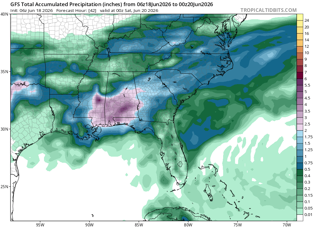
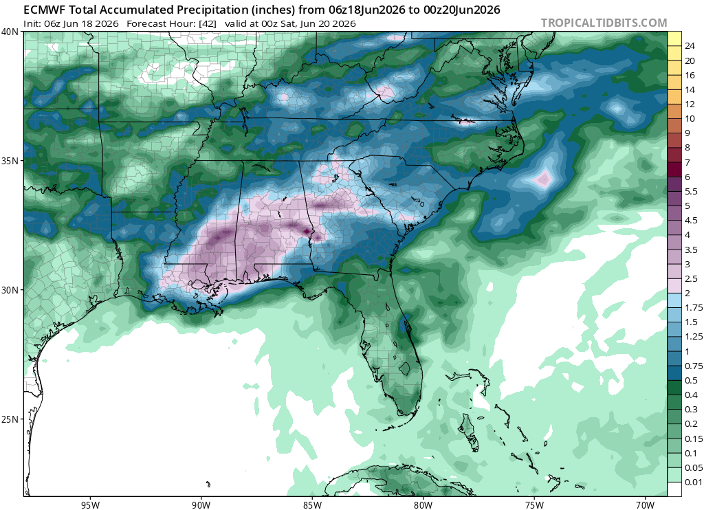
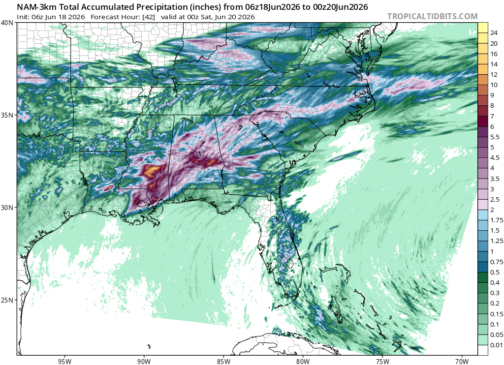
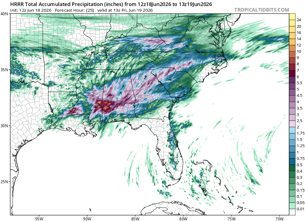
HRRR has nothing for us. And these long range wetter patterns have not verified. Hopefully Monday works out for something-an inch would be great.
-

2026-2027 Super El Nino
snowman19 replied to Stormchaserchuck1's topic in Weather Forecasting and Discussion
I don’t think it will. Just posted about it, but we have yet another very strong WWB forecasted for the end of this month. That will initiate another DWKW. I think these WWBs end up pushing the entire equatorial WPAC/Indo warm pool east. The new EURO Copernicus multi-model run has the 30C isotherm pushing all the way east to 140W by November -
Nice rolling, distant thunder.
-
Maybe we can toss some cadavers on top of the coop from 2k in VT. My chickens would totally eat the scraps.
-
Mesoscale Discussion 1181 NWS Storm Prediction Center Norman OK 0831 AM CDT Thu Jun 18 2026 Areas affected...portions of the Northeast Concerning...Severe potential...Watch likely Valid 181331Z - 181530Z Probability of Watch Issuance...80 percent SUMMARY...Thunderstorms to shift eastward with potential for damaging wind and perhaps a tornado. DISCUSSION...Low topped convection will continue eastward this morning across portions of the Northeast. Strong southerly flow is ushering in higher dew points ahead of this line. Though cloud cover is prominent, further destabilization is expected to occur through filtered heating into the early afternoon with MLCAPE around 1000 J/kg progged by the afternoon. Given the strong mid-level flow and low-level jet, damaging wind potential will likely increase into the afternoon. Given strong low-level shear profiles, a couple of tornadoes are also possible. A watch will be needed soon to cover this potential. ..Thornton/Hart.. 06/18/2026 ...Please see www.spc.noaa.gov for graphic product... ATTN...WFO...GYX...BOX...BTV...OKX...ALY...BGM...BUF...CTP... PBZ... LAT...LON 43017777 41647945 41407616 41587391 42387246 44077204 44817237 44887508 43017777 MOST PROBABLE PEAK TORNADO INTENSITY...85-110 MPH MOST PROBABLE PEAK WIND GUST...55-70 MPH
-

2026-2027 Super El Nino
LakePaste25 replied to Stormchaserchuck1's topic in Weather Forecasting and Discussion
So far this is preventing us from having a cooler summer. The summers of 1997, 1982, 1972 were well below normal here. We will see if this competing forcing will continue into the fall. -

2026 Mid-Atlantic Severe Storm General Discussion
high risk replied to Kmlwx's topic in Mid Atlantic
There is some hint of destabilization later today in guidance, and it wouldn't take much with these wind fields, so I don't think we're totally dead. That said, the models have a lousy handle on the ongoing convection, so the idea that we may be too stable is valid.- 791 replies
-
- 1
-

-
- severe
- thunderstorms
- (and 7 more)
-
Sounds like Tornado Watch coming per MCD
-
Nah I’m pumped for the convection 200 miles away. I can’t stay away from the screen.
-
Records: Highs: EWR: 97 (1993) NYC: 95 (1929) LGA: 95 (1994) JFK: 94 (1962) Lows: EWR: 49 (1950) NYC: 48 (1950) LGA: 49 (1950) JFK: 53 (1959) Historical: 1835: A tornado moved southeast across west central Illinois, touching down midway between Canton and Fairview. Farms were destroyed before the tornado moved across Canton, where 50 buildings were damaged or destroyed. The tornado killed 8 people, including the founder of Canton and his son.(Ref. Wilson Wx. History) 1875 - A severe coastal storm (or possible hurricane) struck the Atlantic coast from Cape Cod to Nova Scotia. Eastport ME reported wind gusts to 57 mph. (David Ludlum) 1939: Anoka Tornado Takes Nine Lives; 250 Homes Ruined. The tornado struck with sudden fury at 3:28 p. m. Moving from the southwest to northeast, the towering, black, funnel-shaped cloud first struck near Corcoran, a small village a few miles southwest of Anoka. It hit a car in which four Minneapolis persons were riding, tossed it 200 yards into a field, killing several of the occupants. A local newspaper reported some chickens were stripped of many of their feathers during the tornado. (Ref. See the Image of the Chicken) (Ref. Anoka Tornado Stories) 1958 - Hailstones up to four inches in diameter killed livestock as a storm passed from Joliet to Belfry in Carbon County MT. (The Weather Channel) 1970 - Wind and rain, and hail up to seven inches deep, caused more than five million dollars damage at Oberlin KS. (The Weather Channel) 1972: Hurricane Agnes was one of the most massive June hurricanes on record. The system strengthened into a tropical storm during the night of the 15th and a hurricane on the 18th as it moved northward in the Gulf of Mexico. 1972: Hurricane Agnes moved northward through the Gulf of Mexico at 10 to 15 mph about 200 miles off the west coast of Florida. It was well west of Ft. Myers at 2000 on the 18th and passed west of Tampa near 0600z on the 19th and made landfall in the Panhandle near Cape San Blas in the afternoon. Gale force winds were felt throughout the state, but no hurricane force winds were reported. Agnes spawned the worst tropical cyclone severe weather outbreak in Florida history on this date and the 19th when the outer rainbands produced tornadoes and severe thunderstorms over the peninsula. Almost two dozen tornadoes and windstorms were reported from the Keys to Cape Canaveral. Six people were killed and 40 injured in Okeechobee when a series of windstorms, that may have been tornadoes, destroyed mobile homes at 2255z on the 18th. The highest tides in many years along the west coast destroyed homes and businesses, washed away roads and cut off access to many offshore islands. There was severe beach erosion. Damage estimates total $5 million dollars to public property and $36 million dollars to private property. One person drowned on the west coast and another death was attributed to a storm-related fatal heart attack. (Ref. Wilson Wx. History 1973: The latest significant snow (2 inches or more) on record for the Black Hills in South Dakota occurred on this date when portion of the Hills received up to 8 inches. 1987 - It was a hot day in the Upper Great Lakes Region. Nine cities in Michigan and Wisconsin reported record high temperatures for the date. The high of 90 degrees at Marquette, MI, marked their third straight day of record heat. Severe thunderstorm in the Northern and Central High Plains Region spawned half a dozen tornadoes in Wyoming and Colorado. Wheatridge, CO, was deluged with 2.5 inches of rain in one hour. (The National Weather Summary) (Storm Data) 1988 - Severe thunderstorms in eastern North Dakota and northern Minnesota produced hail three inches in diameter and spawned four tornadoes in Steele County. Thunderstorms also produced wind gusts to 80 mph at Clearbrook MN. (The National Weather Summary) (Storm Data) 1989 - Unseasonably hot weather prevailed in the southwestern U.S. In Arizona, afternoon highs of 103 degrees at Winslow, 113 degrees at Tucson, and 115 degrees at Phoenix were records for the date. (The National Weather Summary) 1991: Atlanta, GA recorded a new record for the amount of rainfall in one hour as 3.47 inches fell between 6:52 pm and 7:52 pm EDT. (Ref. Wilson Wx. History) 1993: In west central Kansas, heavy rain caused roads in the Syracuse area to flood. As much as one foot of water covered some roads for a short period of time. In Greeley County, golf ball size hail, driven by thunderstorm winds, damaged wheat and broke windows along a four mile path from five miles south of Astor to nine miles south of Astor. (Ref. Wilson Wx. History) 1997: Over 6 inches of rain fell at Columbia, MS in a three hour period and 8.25 inches fell in a 24 hour period. Water entered thirty businesses in Columbia, with 12 of the businesses suffering major damage. Eight homes also suffered flood damage. Many roads were washed out and had to be closed. Numerous cars were under water. This event caused $15 million dollars in property damages. Several roads were also flooded across the south half of Forrest County. (Ref. Wilson Wx. History) 1999: Record morning chill occurred across the Appalachians. Record lows for the date included: , Elkins, WV: 39 °F, Pittsburgh, PA: 43 °F, Bluefield, WV: 46 °F. (Ref. Wilson Wx. History)
-
For sure. Weird seeing positive trends for once
-
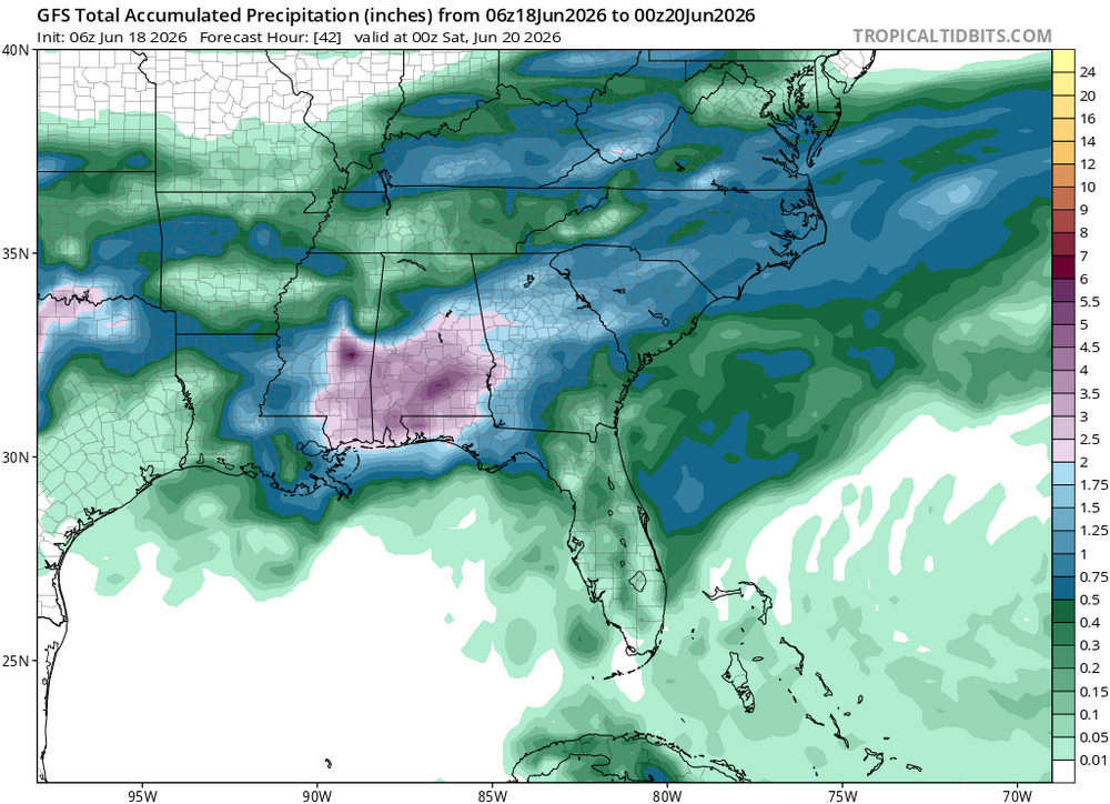
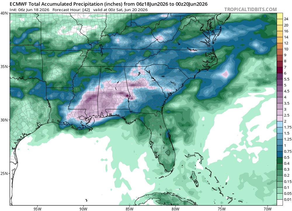
We are in the 3rd flash flood watch since last Friday. The first 2 provided 1.43" but flow on the local 4th-order watercourse (Sandy River) has barely stayed above the 25th percentile. The initial watch verified in a small area around Conway NH with reports of 3-5" and quick flooding, while 99%+ of the watch areas had a nice drink.
-
Hello little skinny line.
-
I suggest you log off and enjoy the New England gray overhead these next 10 hours.
-
super el nino banter thread
LakePaste25 replied to forkyfork's topic in Weather Forecasting and Discussion
why is snowman 5 posted? i dont see how busted warm calls are any different than metfan’s busted april snow maps. Are people that sensitive they can’t handle someone making warm forecasts? -
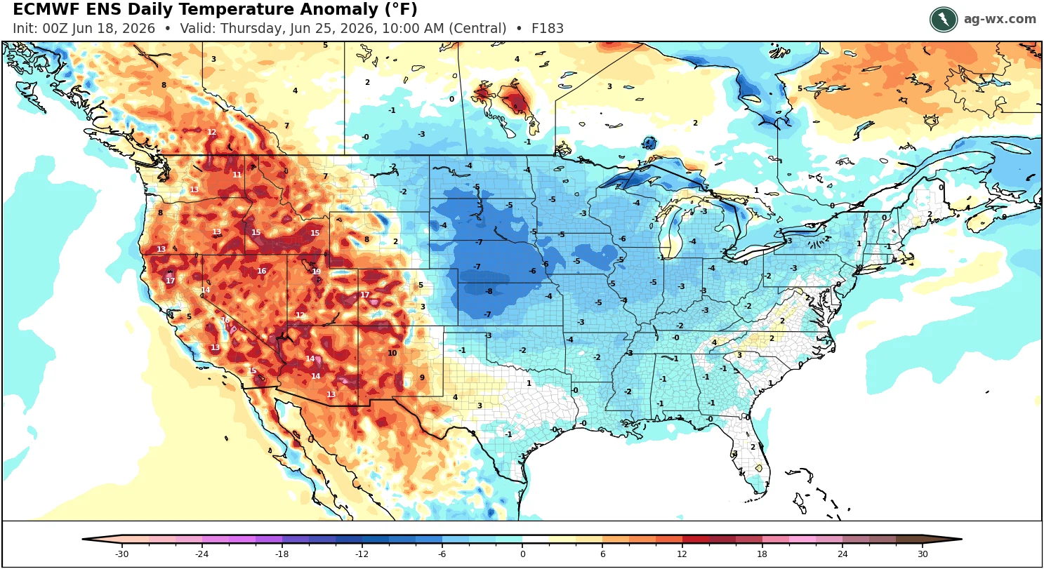
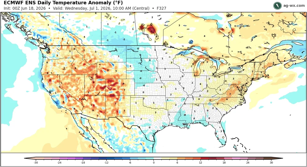
77 / 68 clouds. Pending on clearing most places will be topped out at mid - upper 80s, enough breaks in the clouds will get the warm areas to 90s. Fri - Sun looks great near normal / dry - great weekend upcoming. Monday the next shot at some >05 and maybe 1.00 of rain with storms etc. Trough into northeast generally 6/20 - 6/27 and near / below normal during the period. Beyond there warmer to close the month / open next , with next chance of heat.
-
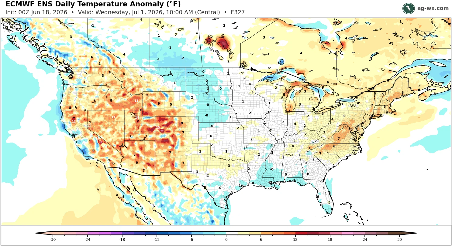
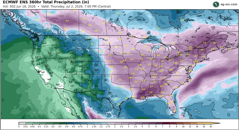
Hopefully, the EPS is correct about the wetter pattern for late June. Coincides with the cooler pattern and a deeper trough in the forecast. Very long range forecasts are trying to bring back the warmth for early July. So we need to get some rains before more potential drying warmth.

-
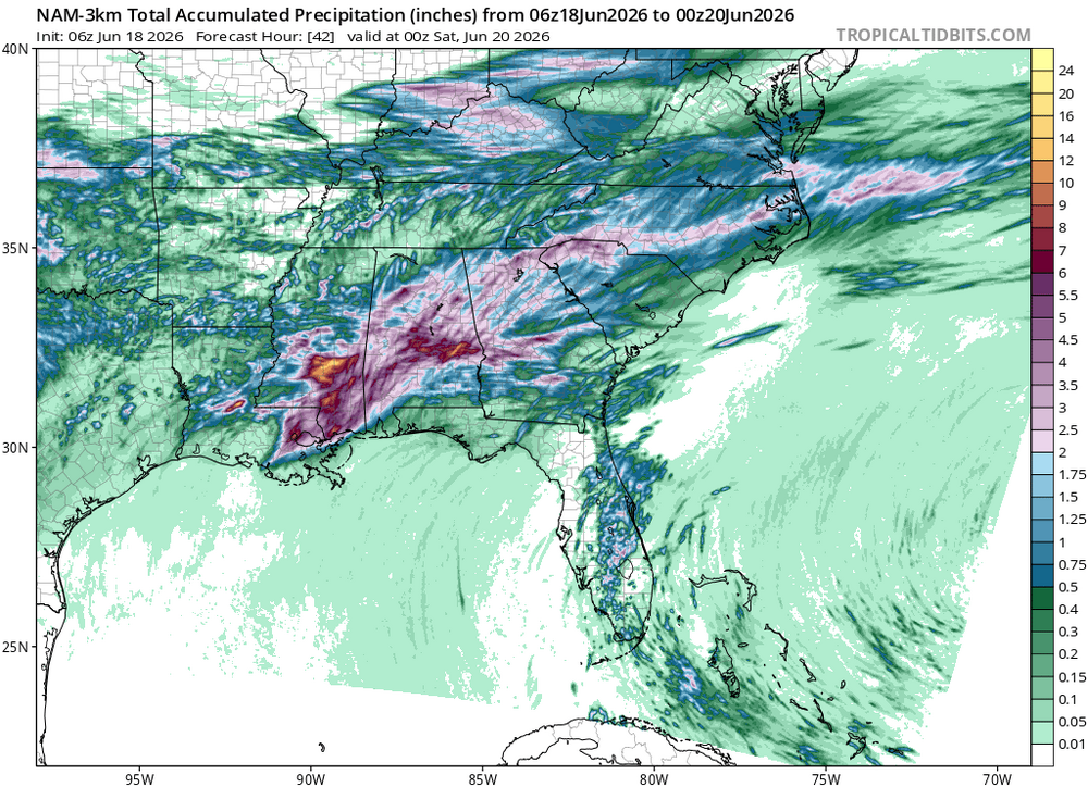
Pouring the rain here in Cherokee.
-
How many cattle will be thrown into the air in Vermont?
-
yes
-
HRRR gone wild up north.
-
Heavy downpour! Short range models stunk this am. Approaching .20 with more to come.
-

2026 Spring/Summer Mountain Thread
Maggie Valley Steve replied to Buckethead's topic in Southeastern States
Moderate rain this morning in the Valley.