All Activity
- Past hour
-
Yes. I am very happy to see the GFS back in line with essentially all other guidance for this region and that (hopefully!) its 12Z cycle just an aberration that won't happen again. Lends a lot more confidence to at least a really solid warning-level event here with decent potential for a lot more upside.
-
GEFS is more mixed bag for NC instead of snow
-
the only major changes in 2016 were bringing the NYC area into the game.
-
 Thats my initial thinking as well, this storm may be too strong to be as far south as depicted on the gfs but may be too cold to jackpot our area. DC-ACY seems like the sweet spot but I do think warning level snows are possible in this sub forum.
 -
It’s only Tuesday, we don’t want large swings. Subtle ticks from now until week’s end is fine.
-
Gefs AI big shift north. DC went from .6 to 1.1” qpf. Gets .8” to the M/D line.
-

January 2026 regional war/obs/disco thread
Typhoon Tip replied to Baroclinic Zone's topic in New England
18z GFS is partially collapsing toward the earlier consensus. The 18z Euro should be interesting... -
Movin' on up to the East Side ...
-
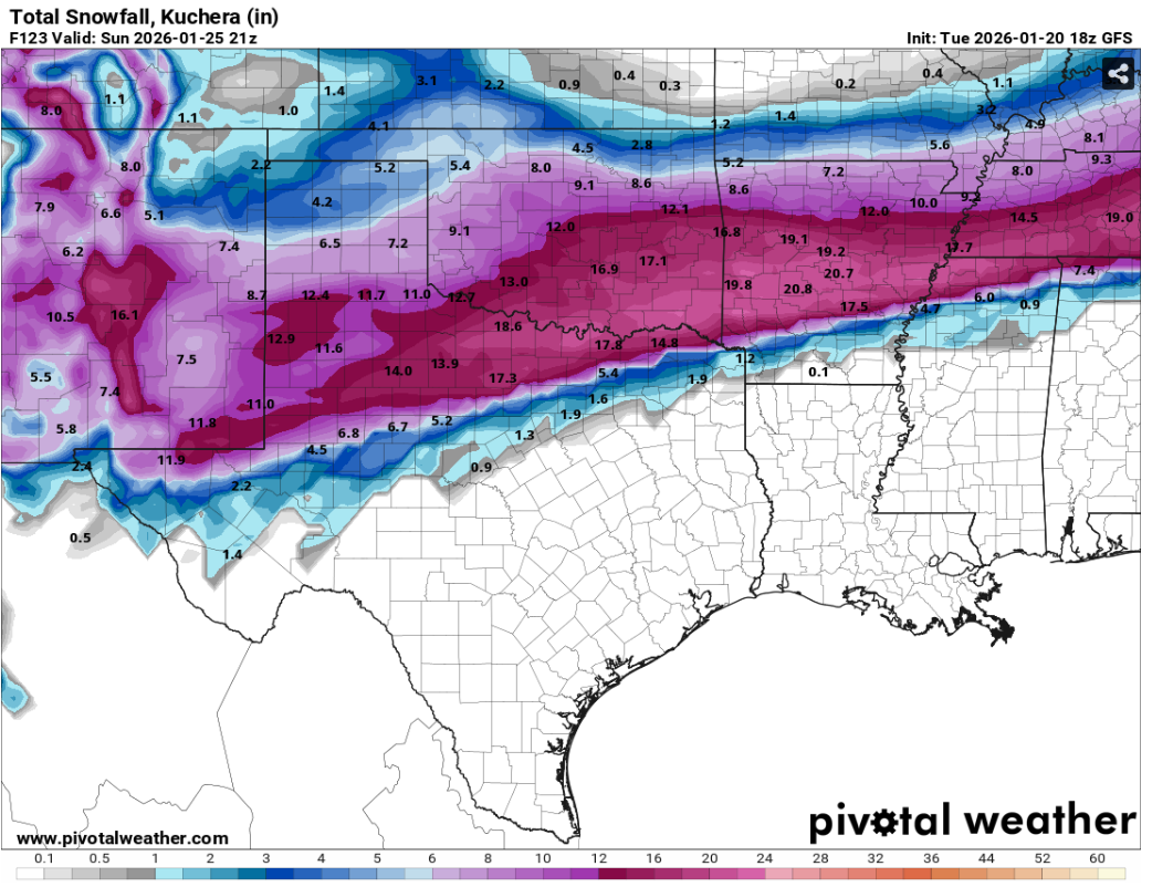
This ORF for jan 1966. More mixing for storm 2 than i had. 2nd to right is the snow accu 1966-01-25 32 28 30.0 -11.8 35 0 T T 0 1966-01-26 33 27 30.0 -11.8 35 0 1.34 7.1 2 1966-01-27 35 25 30.0 -11.9 35 0 0.24 2.3 9 1966-01-28 33 19 26.0 -15.9 39 0 0.00 0.0 8 1966-01-29 33 18 25.5 -16.5 39 0 0.96 4.6 8 1966-01-30 24 12 18.0 -24.1 47 0 0.06 0.2 8 1966-01-31 31 10 20.5 -21.7 44 0 0.00 0.0 7
-

January 2026 regional war/obs/disco thread
TheSnowman replied to Baroclinic Zone's topic in New England
I just asked AI if there were Any videos of December 23, 1997 during the famous hour of heavy snow, it said No. Though it could describe the event very well. NOT as well as our man Tip though! I have no recollection of it at all; I was probably seeing non-accumulating wet flakes. -
It's pretty apparent a lot of us will mix. I don't think it'll be as severe as the CMC but I highly doubt we see the gfs slider as a final result. The energy flying around from the Baja will "kink" the flow enough to give us a NE tilt vs the flat look. Gfs has been all over the place and its ensemble doesn't match it very well.
-
Good to see the snow depth almost the same or at least in-line with the snowfall. I guess that's to be expected given how cold it is supposed to be. This isn't something that will just melt off and we have nothing much on the ground even if the actual "accumulation" is higher.
-
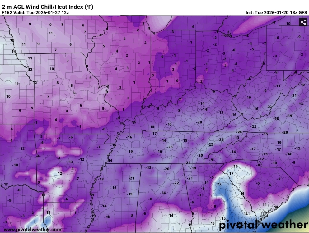
This is what has me the most worried...major power failure across the south and then this behind it. Wind chill values 18z GFS.
-

January 2026 Short/Medium Range Thread
Weatheriscool replied to John1122's topic in Tennessee Valley
It appears to my untrained eye that the STJ gets involved the rest of the month into Feb and the trough essentially remains in the east, there could be more systems yet to go -
Would be nice to see another tick or two
-
We are now in silly mode. That’s the mode after storm mode. Strap in
-
Nice storm after the storm potential. I mentioned this several days ago in a post. Probably belongs in the other thread, but no one is paying much attention to that at this point lol. This is where its at.
-

January 25/26 Jimbo Back Surgery Storm
NorthHillsWx replied to Jimbo!'s topic in Southeastern States
I have to keep reminding myself that the gfs is a terrible model but… -
I'd like to take a moment to thank @mappy, @stormtracker, and all the Mods for how they've handled the storm thread. It is SO MUCH more readable without all the useless childish and whiny posts at every single slight change in the models each cycle. Even today with the 12Z GFS (and AI-GFS) looking lousy, it was more a discussion and level-headed assessment, and not page after page of (ahem, JI and some others!) with tearing of hair, gnashing of teeth, bitching about how we lost 15" of snow or how we suck, or how it's over, whatever. Much appreciated!
-
2000 was close!? Wait, that actually verified. I suppose the question for experts on here, have you ever seen something as consistently modeled over a few days ultimately vanish?
-

Richmond Metro/Hampton Roads Area Discussion
RVASnowLover replied to RIC Airport's topic in Mid Atlantic
GEFS looked good…obviously -
Been busy and I come back to this output. Good God almighty. Danville, VA would be pounded into the F’in stones with that. GFS will come north and scale back in magnitude, but this is truly turning into what could be a special storm for so many. EC and GEM leading the charge along with the AIFS and Ensemble output. The hi-res are absolutely going to have some bonkers runs later this week and weekend. I like what I am seeing.
-

Winter 2025-26 Medium/Long Range Discussion
Powerball replied to michsnowfreak's topic in Lakes/Ohio Valley
The meltdowns to beat all meltdowns incoming (Beavis will have nothing on me) if this happens...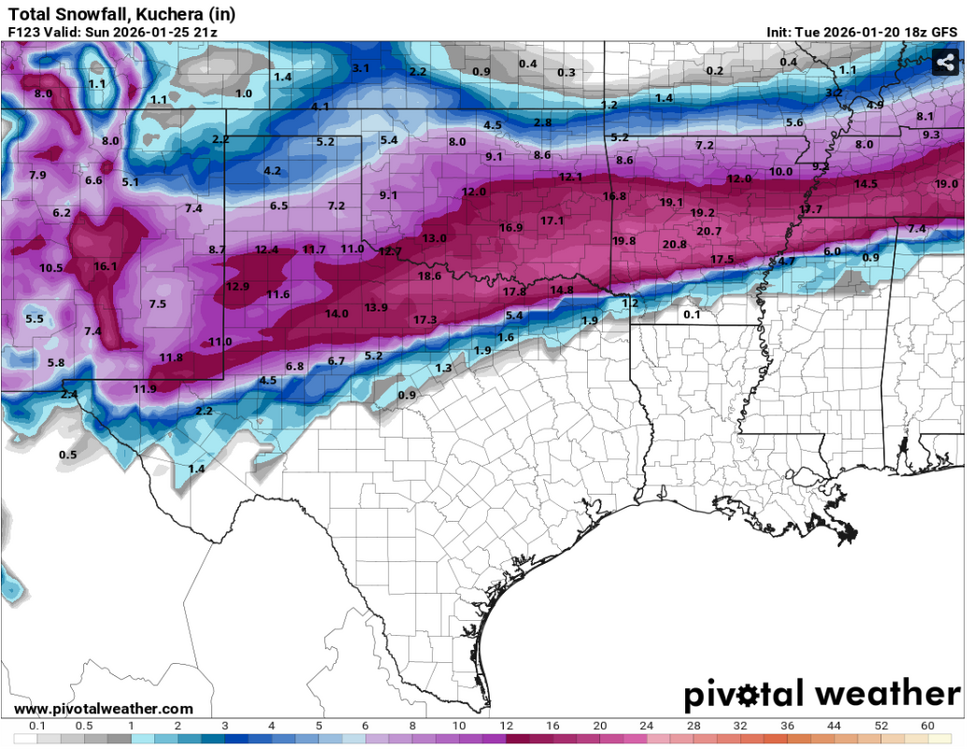
-
That's probably the closest the red has been to MD so far!
-
fro those who follow Bernie Rayno, he has posted another video on X within the last hour... naturally he believes the GFS is "off its rocker"...