All Activity
- Past hour
-

November 2025 general discussions and probable topic derailings ...
Typhoon Tip replied to Typhoon Tip's topic in New England
Not to make light of what you feel your situation is ... or is in fact, but doesn't that ( bold ) qualify as a home? -
Pretty cool to see a mesolow make landfall off Lake Michigan. This is the feature that will pivot through the area tomorrow.
-
Sorry to abandon you today brother...that was a really frustrating game. Saving grace is lots of canceled flights out of msp
-

November 2025 general discussions and probable topic derailings ...
MJO812 replied to Typhoon Tip's topic in New England
Winter coming -
Even looks to be a little bit of weak rotation just NW of Owings Mills. Doubt it produces but provides something to watch at least.

-
Freaking November and I’m still getting fringed with storms
-
 some rotation
-
 Just missed. Too bad
-
That map is perfect! .... Please let it be so.
-
Down to 39 now. Temps are diving off the cliff.
-
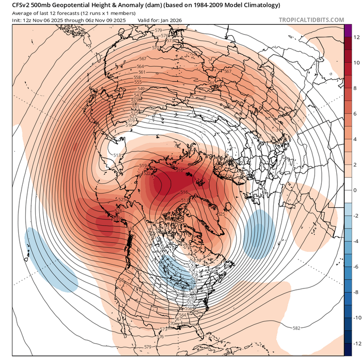
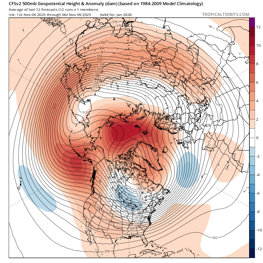
Any opinions about this, which suggests Greenland blocking throughout this winter? @bluewave@snowman19
-
.thumb.jpg.6a4895b2a43f87359e4e7d04a6fa0d14.jpg)
Central PA Fall Discussions and Obs
Yardstickgozinya replied to ChescoWx's topic in Upstate New York/Pennsylvania
Thanks, Snowman. I missed your reply the other day. I didn't want to sound to crazy with the numbers, but I believe it was actually more than eight degrees in a few minutes. I was working right at the east foot of South Mountain in Dillsburg. I'm familiar with mixing, compressional warming, and forcing but what I experienced at the foot of south mountain was exceptionally extreme from what i've experienced outdoors in my lifetime and i've experienced a lot. I wonder how many times i've experienced compressional warming compared to other surface warming dynamics ? Based on what I experienced the other day, I would have to say not much. It definitely feels different.I'll recognize it next time, if that's what it was. -
Could've had Daniel Jones or Sam Darnold in retrospect. Didn't even know how rich they were...
-
Current CFS Jan h5 is a good visual of what I recently posted irt split flow+blocking during a "Nina". This is a sweet looking prog....
-
Down to 44 with a steady W breeze about 20 mph. Under a WWA for 3-6" although this setup, at least imby, is closer to 2-3" kinda deal. I'll go from mid-September to mid-January tho in 24 hours tomorrow night with mid-teens and 35 mph winds. That'll be a shock to the system.
-
Well, it turns out the AI models were on to something with that southerly low track. Saw that Toledo got a nice little thump of moderate to heavy snow with accumulation this morning. As for the LES, this remains a tricky forecast with the amount of instability providing for potential upside, but a lack of band persistence/organization evident on models are a potential significant limiting factor. Starting tonight, (mainly light) synoptic precip with some northerly flow lake/upslope enhancement this evening will give way to more classic lake effect precip after midnight. Conditions will become quite conducive to lake effect by early Monday, with lake-induced equilibrium levels climbing over 10k feet overnight and BUFKIT displaying "extreme" instability by sunrise, with lake to 850mb temp differentials of over 20C and lake to 700mb diffs of around 30C. Lingering synoptic moisture should be fairly abundant in the lowest 10-15k feet much of the night. We should see rain mix with and gradually change to snow this evening in the Cleveland area with the higher terrain going first. It will get cold enough for accumulations by late evening or the overnight under any organized bands, especially inland. There are suggestions of a potential Lake Huron connection setting up well west of Cleveland tonight...with some enhancement near Cleveland into the Medina/Lorain County area also hinted at most of tonight. Farther east, there could be some less organized lake effect/upslope precip overnight into early Monday. I think most of the area will see a light accumulation tonight, though near the lake may not see any stick outside of any localized heavier bands. Snow rates within bands could top an inch an hour overnight but bands may be moving a bit too much...however, a slower moving band would be the opportunity for locally a few inches tonight into early Monday. Winds will shift from N to NW through the day Monday, with a patch of subsidence and drier air working through during part of the day. Lake Huron enhancement will swing east across the Cleveland area and into the Snowbelt on Monday. It will still be quite unstable on Monday so this band may still be heavy at times, but activity outside of any Lake Huron connection could be pretty limited on Monday and accumulations will be harder to come by during the day outside of bands. So, I could see some localized amounts of up to a couple inches during the day Monday, mainly with any activity enhancement by Lake Huron. The most ideal window looks like Monday night into early Tuesday. The core of the closed low/cold core aloft will move right over Lake Erie Monday evening, with NW winds gradually shifting more W Monday night. Conditions will be very conducive to intense LES the first half or so of Monday night...they gradually decline later Monday night into Tuesday, though heavy snow in bands should be supported into early Tuesday at least. The main target Tuesday night will be the Lake Huron connection, which may settle into NW PA for a good chunk of the night. However, a couple of other bands will likely play out across the Snowbelt and Cleveland metro. Bands may again move just enough Monday night to keep amounts somewhat under control, though could see additional 6-10" amounts in PA if the Lake Huron connection is stable enough, with locally several more inches across parts of NE Ohio under more organized bands.
-
 Should be first snow showers for much of SNE Tuesday
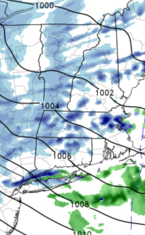
-
It’s all downhill from here .
-
Watch this one into the fanny
-

11/8-11/10 First Snow and Lake Effect Event
sbnwx85 replied to Geoboy645's topic in Lakes/Ohio Valley
Absolutely ripping under this band. I went to pick up pizza for me and gf. Left with moderate snow, 1/2 mile visibility and mostly clear roads. Coming home with heavy snow, 1/4 mile visibility and snow packed roads.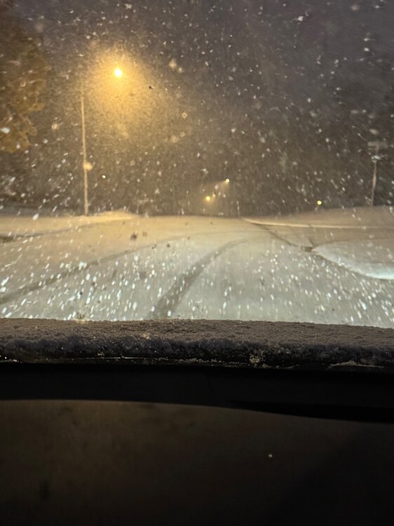
-
I think Seattle signed him for $33 mill/yr. I understand wanting to go with the younger player, but McCarthy is averaging something like 5.5 yds/attempt this year, 53% completion percentage, and 6 INTs/5 TDs.
-
 Don This breaks my heart. What can we do to help?
 -
Gfs is starting to show this . This would most likely be a New England Threat with a big block in place. Like you said it's nice to see this solution.
-
That was my last winter living in western MD, where I had grown up. It rivaled the more-heralded winters of the late 70’s. Had seven below-zero nights in January, including back-to-back -13’F’s. 45” winter in the valley around Cumberland, where the average is about 30”


.thumb.JPG.418e8a9a2902ae687ec35ff4bc0e038e.JPG)


