All Activity
- Past hour
-
Yeah, it’s dumb lol. Friends kids in PA are out today too
-
Good week here with 1.5". Didn't look very promising looking ahead last Sunday.
-

E PA/NJ/DE Autumn 2026 Obs/Discussion
Newman replied to PhiEaglesfan712's topic in Philadelphia Region
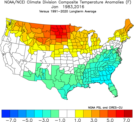
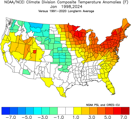
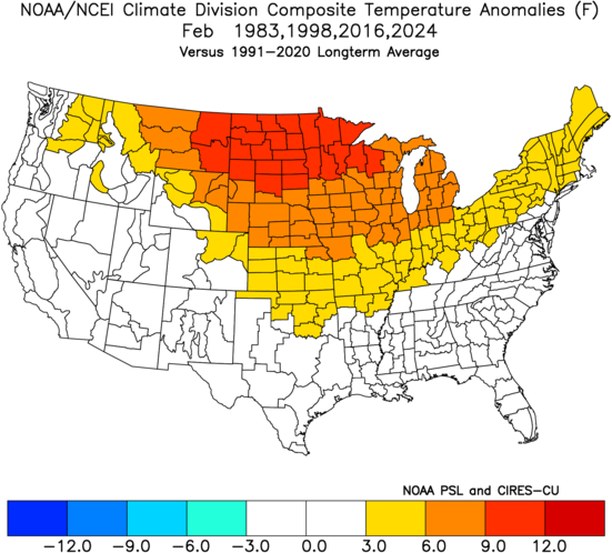
I'm lumping 2023-24 into the group with 1982-83, 1997-98, and 2015-16 given the very strong Nino status (ONI 2.0 in NDJ) and some similarities to the current global pattern (-PDO. Also, given it's the closest year to our newer, warmer trending climate). Here's the temperature anomalies averaged DJF for those 4 winters: It follows a pretty typical Nino look, though I would argue the near to slightly below normal averages in the SE US, and heck even the modest above normal averages in the Mid-Atlantic and Northeast, are skewed by 1982-83, and especially the month of January. Jan 1983 and 2016 were both cold in the Mid-Atlantic and SE US, and like @The Iceman mentioned, we got big dogs both those years: But Jan 1998 and 2024 averaged very warm in the Northeast and Mid-Atlantic: And as far as February goes, most of the strong to super Nino months were warm across the northern tier and cooler in the south. Under the assumption (even if it's unlikely) that the North Pacific doesn't respond to the super Nino (I.e. we have a -PDO into the winter) then 2023-24 would have to be a close analog. Right now, I would lean towards a much warmer January, in the average, similar to 1997-98 or 2023-24. I do not think that the northern Rockies and Central Plains will average cold in January, like those years, but rather will average warm and the Southwest and Southern Plains could be cooler. I'd venture that the warmth extends well up the east coast, unlike 1983 and 2016. Precipitation anomalies are likely to be above to much above normal up the eastern seaboard, with the highest anomalies in the central Appalachians and Southeast US. However, like mentioned in the posts above, there will be a much higher than normal chance for a very big snowstorm. My fear, though, is if the source region for our cold is simply not sufficient enough *when we do get cold northerly flow* for snow down to the coast. It seems like a winter with lots of mix events NW of I-95 and rain more times than not. Should we get a well timed cold blast that's sufficient for snow, then it could be a good one. KPHL snowfall totals for these select years: 1982-83: 37.9 inches (21.3 in the Feb blizzard) 1997-98: 0.8 inches 2015-16: 27.5 inches (22.4 in the Jan blizzard) 2023-24: 11.2 inches KABE snowfall totals for these select years: 1982-83: 45.8 inches (25.2 in the Feb blizzard) 1997-98: 7.7 inches 2015-16: 36.2 inches (31.9 in the Jan blizzard) 2023-24: 25.2 inches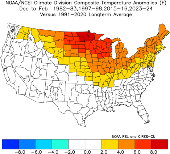
-

2026-2027 Record-breaking El Nino
GaWx replied to Stormchaserchuck1's topic in Weather Forecasting and Discussion
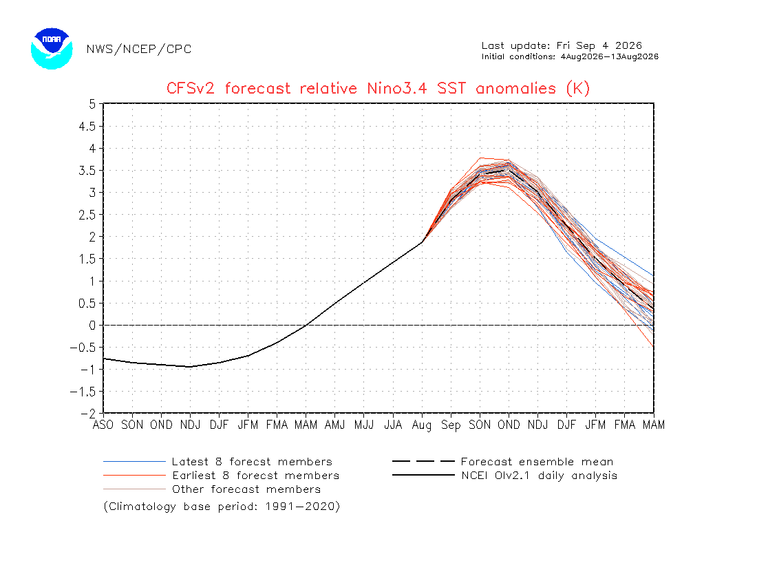
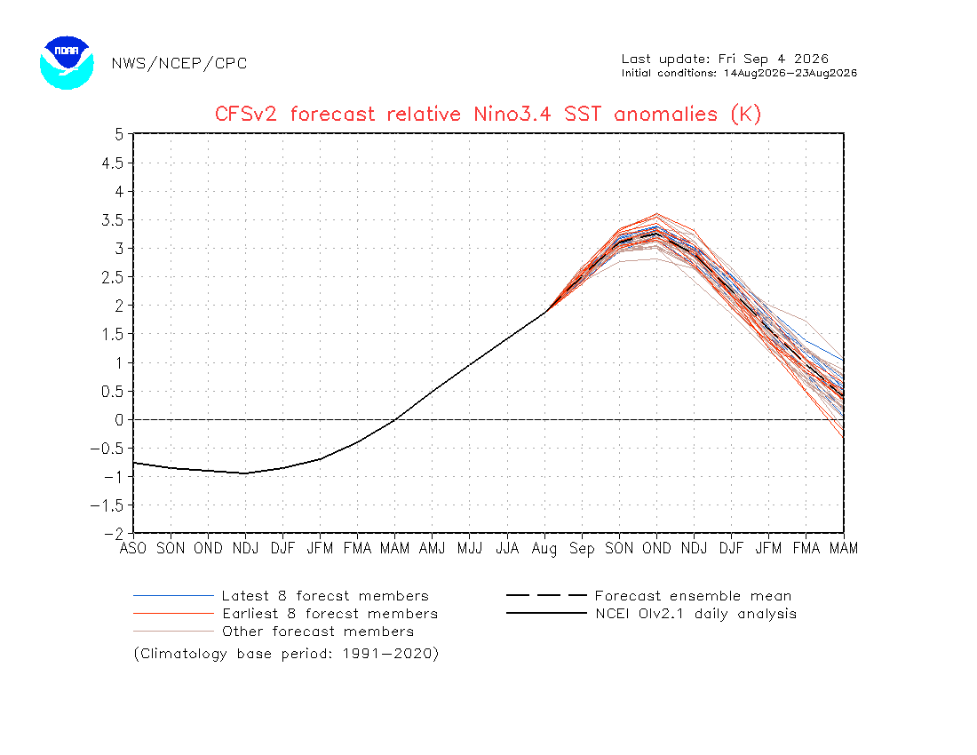
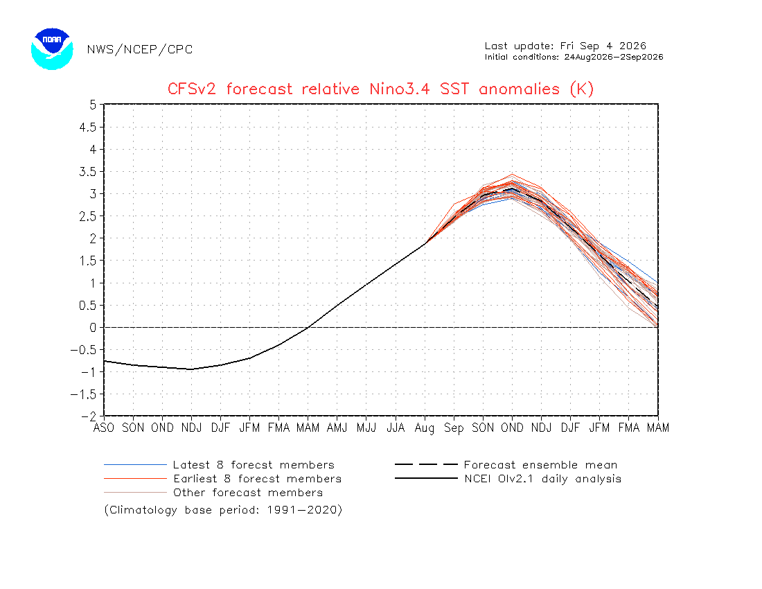
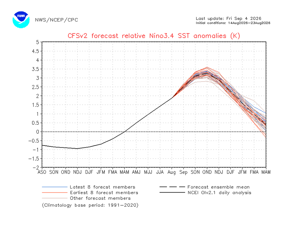
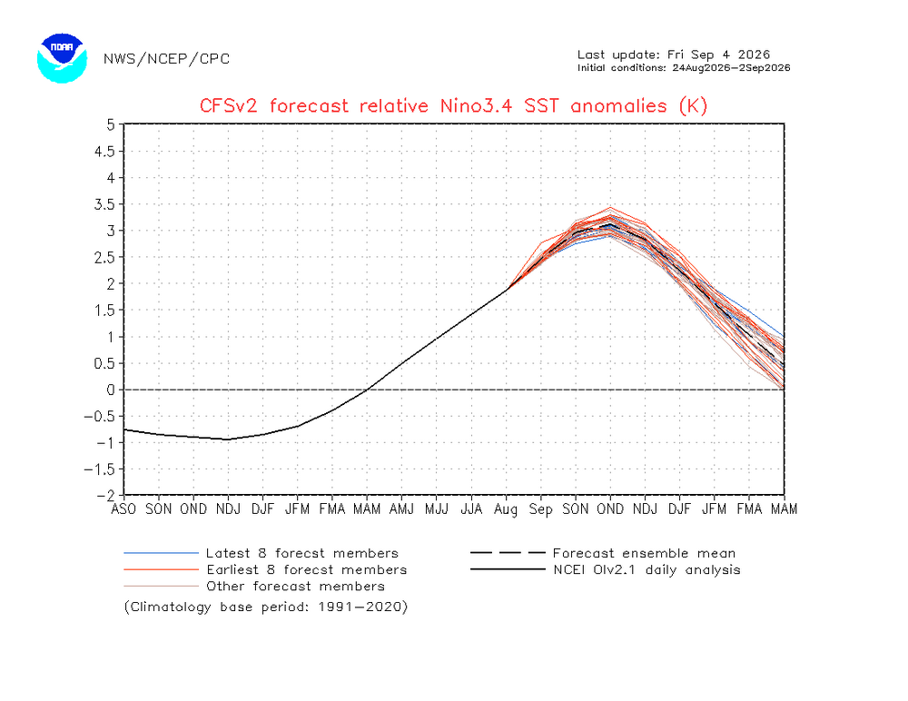
CFSv2 progs for relative Nino 3.4 trimonthly peak continue to cool significantly as the overall flatness of Nino 3.4 still persists (much longer than earlier progged on the models for 3.4): Mean of runs Aug 4-13: OND +3.5 (when the progged peak was at a peak) Mean of runs Aug 14-23: OND back down to +3.25 Mean of runs Aug 24-Sep 2: OND down even further to +3.1! It hasn’t been this low since the 10 day means of late June: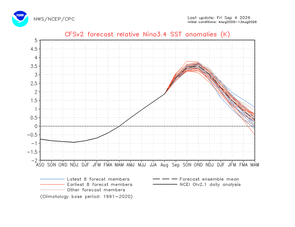
-
I imagine seasonal models will start trending warmer. Right now we are before that infamous Halloween predictability barrier. Now models (as programmed) are amping up Nino response because Nino is on fire. What's next? Warmer forecasts! ATMO has not followed teleconnections for years. First, the oceans are not absorbing heat. Marine heat waves are almost global. See Climate forum for more. Also the PDO remains out of whack. If we have warm Nino and -PDO it'll relentlessly flood the Lower 48 with mild air. My forecast remains a top 10 warm winter. Warmest winter in recorded history is possible.
-

Septorcher 2026 Discussion - Endless Summer
kdxken replied to Damage In Tolland's topic in New England
Folks whining about the weather? Lolz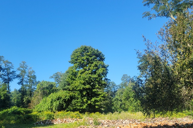
-
dewpoints starting to drop but will be tomorrow before it's really drier.
-
Incredible instability will be available. Unfortunately 15% is probably a good forecast. I was hoping for 30% wind, mainly for QPF. No turning with height, so those blobs are just beefy wind producers. No organized line. Derecho checklist is so far from being met that I'd say we meet the anti-derecho checklist. Simply nothing interesting in weather right now. When's the next comet or eclipse? We need some Northern Lights!
-

Fall 2026 Medium/Long Range Pattern Thread
Carvers Gap replied to John1122's topic in Tennessee Valley
Yeah, it has been a furnace. I don't remember September being hot during Nino climatology. I do remember Octobers being cold. We need some cool air. These fall athletes are living in heat purgatory right now. They need a break! Reminds me of La Nina falls. Maybe the atmosphere is just repeating the pattern regardless of ENSO? Warm fall - endless summer. Flip to winter temps, 2-4 week lull, more winter, and short spring? At some point, fall "should" be cloudy and cool if Nino has anything to say about it - minus the flip. -

Septorcher 2026 Discussion - Endless Summer
rimetree replied to Damage In Tolland's topic in New England
Can we bring back the coastals this fall? NE 35 with gusts to 55 maybe. -
Just got hit with a lake enhanced outflow, back to paradise climo
-
So much for cooler and less humid Very uncomfortable
-

Septorcher 2026 Discussion - Endless Summer
weatherwiz replied to Damage In Tolland's topic in New England
The upper-level pattern has done wonders to really warm the waters too in recent weeks. +28C to +29C up to the NC/VA border Speaking of water temperatures, where all the people freaking out about that "cold blob" in the north Atlantic that is no longer really there -

Septorcher 2026 Discussion - Endless Summer
ineedsnow replied to Damage In Tolland's topic in New England
https://x.com/foxweather/status/2095874526978654260 -
.26” overnight at home, 2.59” for the month already. I’m currently up at Mount Snow for the annual guys trip to the Brewfest tomorrow. Glorious mountain air up here today getting better by the minute. 69/62 at the closest Davis to here, yesterday was muggy with dews in the upper 60’s up here.
-
I expect the hottest September on record. More mid-90s next week is just about enough to seal it - especially weighted toward AC use. But let's talk about simple temperatures. A brief mid-month front may give way to yet more SER activity. We can only hope it retrogrades a bit. Otherwise - hottest September in recorded history!
-
Septorcher 2026 Discussion - Endless Summer
ineedsnow replied to Damage In Tolland's topic in New England
Hopefully.. those waters are pretty much untouched so far.. -

2026-2027 Fall/Winter Mountain Thread
BlueRidgeFolklore replied to BlueRidgeFolklore's topic in Southeastern States
-
Another .75" overnight
-

Septorcher 2026 Discussion - Endless Summer
CoastalWx replied to Damage In Tolland's topic in New England
I am being objective. -
Septorcher 2026 Discussion - Endless Summer
CoastalWx replied to Damage In Tolland's topic in New England
Depends on how it behaves. 40 and mud makes me want to martyr myself. -
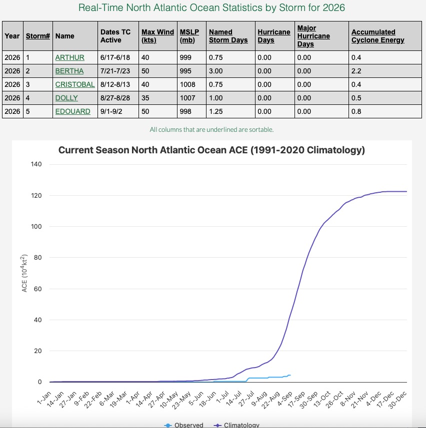
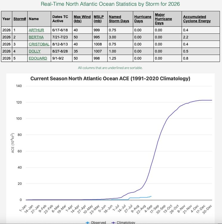
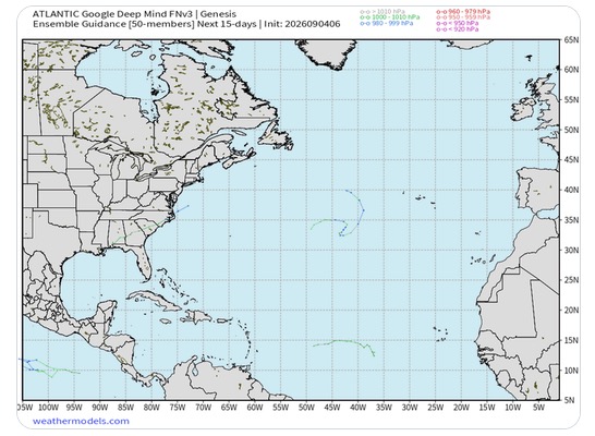
Just in case you were wondering what the status of the 2026 hurricane season is: That is one quiet looking signal from Google Deep Mind going into mid month. If we make it to September 11 with no hurricanes (seems likely) we will break the record for latest in the season with no hurricanes in the satellite era.
-
September 4 1992: Early morning storms result in 3/4 to 1 3/4 inch hail in Hennepin, Dakota, Rice and Goodhue Counties. 1941: A batch of tornadoes hits Minneapolis, New Brighton, and White Bear Lake, killing six people. 1925: The third consecutive day of 95 degrees or above occurs in the Minneapolis area. For Friday, September 4, 2026 1939 - A thunderstorm deluged Washington D.C. with 4.4 inches of rain in two hours. September of that year was very dry across much of the nation, and Washington D.C. received more rain in that two hour period than most other places in the country that entire month. (David Ludlum) 1970 - The greatest natural disaster of record for Arizona occurred. Unprecedented rains caused rivers in central Arizona to rise five to ten feet per hour, sweeping cars and buildings as far as 30 to 40 miles downstream. Flooding claimed the lives of 23 persons, mainly campers, and caused millions of dollars damage. Water crested 36 feet above normal near Sunflower AZ. Workman's Creek was deluged with 11.40 inches of rain in 24 hours to establish a state record. Moisture from Pacific Tropical Storm Norma led to the severe flooding. (4th-6th) (The Weather Channel) 1986 - An unusually strong dust devil moved across the Flagstaff Pulliam Airport. The dust devil blew open the doors of the National Weather Service office scattering papers and bringing down a ceiling-mounted light fixture. (Storm Data) 1987 - Thunderstorms developing along a stationary front produced heavy rain across the Southern Atlantic Coast States. Up to eight inches was reported north of Charleston SC. Serious flooding was reported in Monks Corner SC. Seven cities in the northeastern U.S. reported record low temperatures for the date. Houlton ME dipped to 32 degrees. (The National Weather Summary) (Storm Data) 1988 - The western U.S. experienced another day of record heat. The afternoon high of 91 degrees at Stampede Pass WA established an all-time record for that location, and Los Angeles CA equalled their all-time record high with a reading of 110 degrees. A record high of 107 degrees at San Diego CA was their hottest reading in 25 years. Red Bluff CA was the hot spot in the nation with an afternoon reading of 118 degrees. (National Weather Summary) 1989 - Overnight thunderstorm rains of four and a half to seven inches drenched eastern Nebraska during the morning hours, pushing creeks out of their banks, and flooding fields, country roads and city streets. Totals ranged up to 6.97 inches south of Creston. It was also a soggy Labor Day for northern Florida. Jacksonville reported 6.82 inches of rain, and evening thunderstorms produced 2.75 inches of rain in one hour at Sandlewood. (Storm Data) (The National Weather Summary) Observances: 4 Fri National Lazy Mom’s Day 4 Fri National Food Bank Day 4 Fri World Sexual Health Day 4 Fri National Wildlife Day 4 Fri Eat an Extra Dessert Day 4 Fri Bring Your Manners To Work Day 4 Fri Janmashtami 4 Fri National Macadamia Nut Day
-

Fall 2026 Med/Long range discussion
SchaumburgStormer replied to Brian D's topic in Lakes/Ohio Valley
Winter cancel -
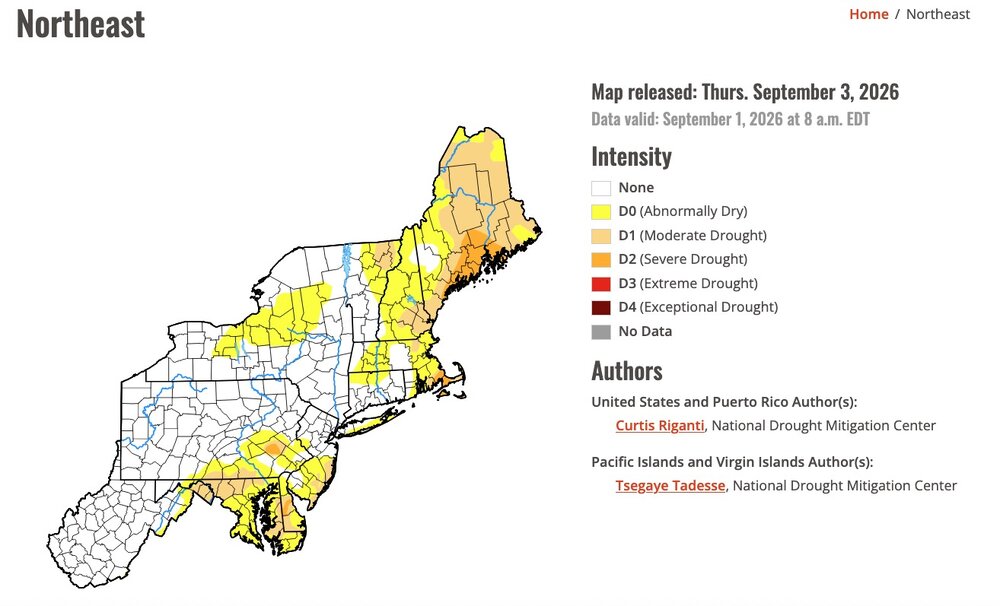
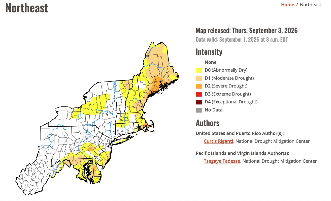
Just in case you were wondering about what the latest Drought Monitor looked like: I think we're all GOOD !