All Activity
- Past hour
-
It's possible, but the history on super Nino's would imply the last likely outcome is that "in between" scenario. The key is going to be the exact location of two features. The North Pac low and the AO/NAO high/block. These two features showed up in almost all the analogs. But there is a balancing act on how they play off each other. The further east the Pac low is the worse it is for us. The further southwest the NAO/AO high is...for instance if it ends up centered over Quebec instead of truly in the NAO domain...the worse.. about half the super nino's that combo ended up toxic...the PAC low too far east blasting pac puke across the whole continent all winter...and the AO/NAO high too far southwest so that it didn't help block down even domestic cold from canada but instead just "blocked" the pac puke over the lower 48 all winter...and in those winters it was simply mild and wet all winter. The more favorable winters, that combo was more favorable, enough so that we were able to get some windows and cash in on one or two of the STJ waves for a huge snowstorm. There weren't many examples of in between. 2024 maybe but that was a really odd winter where a strong nino never acted like it and I don't expect that to happen again give the combo of how strong this is and the PDO seeming to be coming off the peak of its cycle.
-
Someone could make $ them making this available for a fee. I’d use it. But then again I’m weird so maybe there isn’t much demand.
-
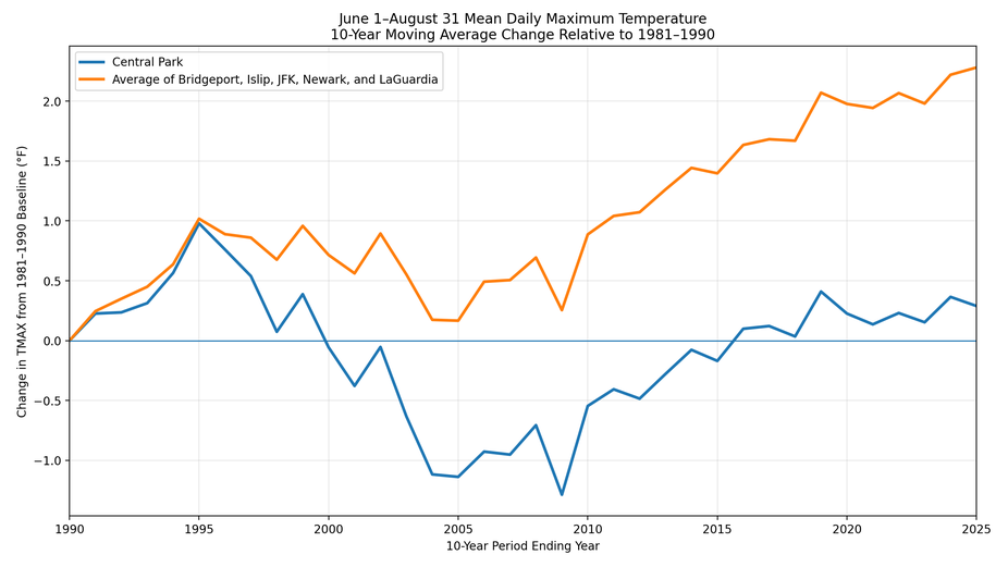
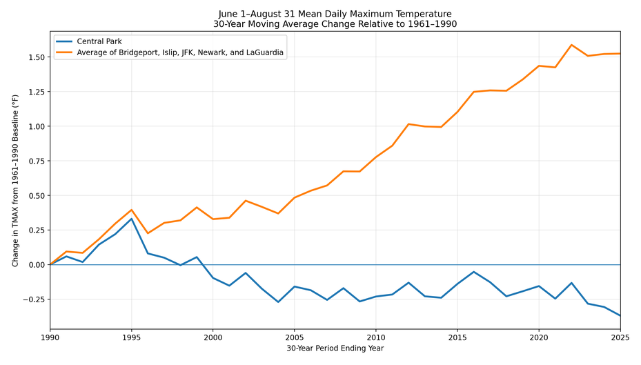
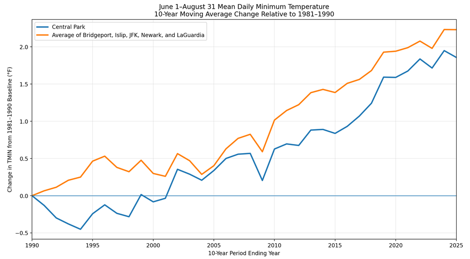
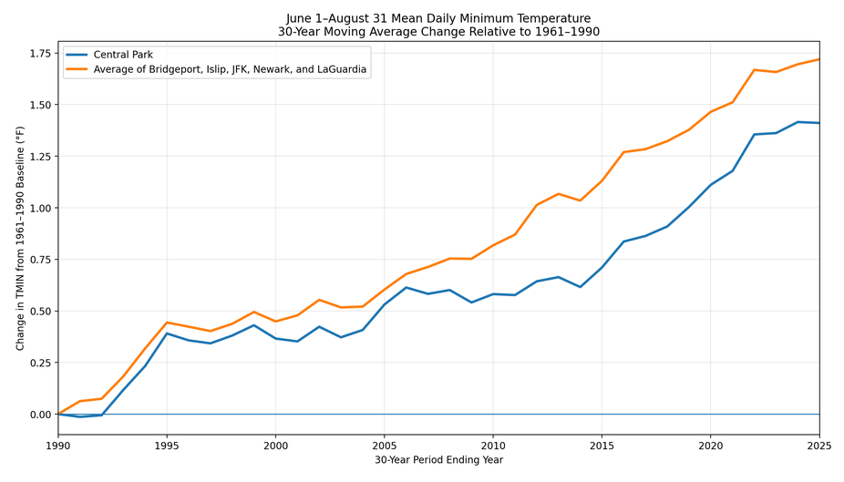
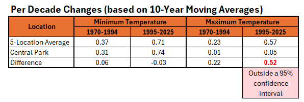
As summer concludes, additional charts illustrating the impact of Central Park's trees on its summer maximum temperature trend vs. select regional sites. Maximum temperatures are most impacted (consistent with the impact trees have on limiting the daily maximum temperature). Moreover, the difference between regional trends and Central Park is outside a 95% confidence interval for daily maximum temperatures during the 1995-2025 period. Maximum Temperatures: Minimum Temperatures:
-

2026-2027 Record-breaking El Nino
michsnowfreak replied to Stormchaserchuck1's topic in Weather Forecasting and Discussion
Makes sense. After almost any winter rainstorm there's a lake snow response. -
CSU MLP has a decent area of 5+% TOR for Sunday.
-

2026-2027 Record-breaking El Nino
bluewave replied to Stormchaserchuck1's topic in Weather Forecasting and Discussion
I don’t take any of this personally. It’s more comical than anything else. The squabbles in these threads are more like Napoleon Vs Uncle Rico than anything really serious. -
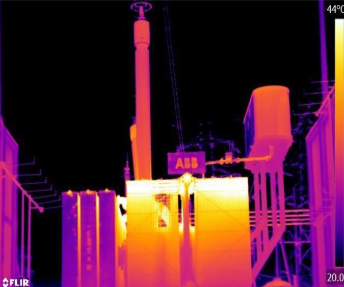
 As an example of why breakpoint detection is absolutely essential, and where there are no alternatives besides something like a pictorial history of the station, Coatesville is a winner. From 1946 on to 1982, Coatesville station was at the Newlinville electric substation. The electric substation is constructed about 1927 to supply the steel works in town, and takes high voltage transmission line power and steps it down. BIG transformers are involved. The Newlinville electrical substation was frequently redesigned to meet the needs of the steel works. Transformer technology improves over time, with less waste heat. A cooling pool is installed at one point to take transformer heat during high loads, and is removed after 2005. So, we have a station with massive heat sources, that are moving as the station expands, and we need to detect changes in the station environment. This obviates all the musings about what caused a precise shift at time X and magnitude Y--this microsite is literally a thermal zoo. Automated breakpoint detection is the only way to salvage this data. Attached is a figure showing estimated power increases over time, developed from historical uses. These increases would have forced numerous changes over time at the substation. And consider, if a new transformer/switchgear is being installed, it would occur at a new pad on the site, while the old transformer/switchgear remains in operation. On change over, the newer transformer/heat source has moved abruptly, and the old transformer idled and eventually removed. Breakpoint. And the new heat source is very likely southwest from the earlier heat source, and very likely further away from the weather station. Attached also is a random thermal image of a substation.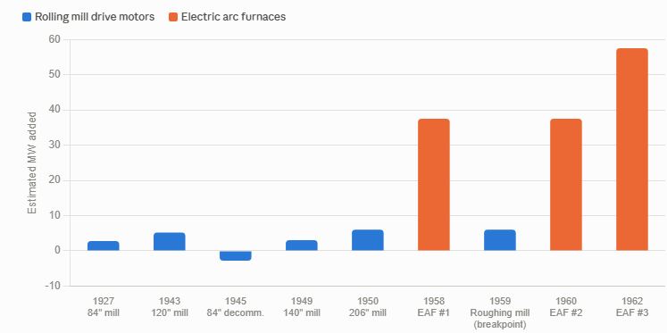
-
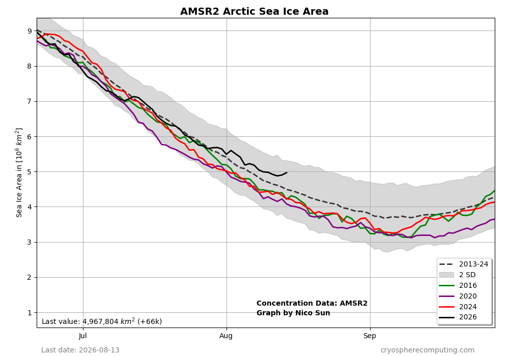
The relatively good news continues as regards the Arctic sea ice area:
-
Cracy considering we were 72 for a low last night here at KDTW.
-
 https://mapletrustrx.com/# Maple Trust Rx
 - Today
-
canadian valley pharmacy [url=http://mapletrustrx.com/#]legal to buy prescription drugs from canada[/url] Maple Trust Rx
-
Sorry to hear that. I have a colleague whose son just graduated with an engineering degree from a good school and can’t even get an interview.
-

Augdewst 2026: Summer's Last Stand
tamarack replied to Prismshine Productions's topic in New England
The Maine Public Lands "peer review" field trip was Tues/Wed in the woods south from MLT, and we saw very few mosquitos, black flies, almost no deer flies (thankfully). Had 0.22" from a 'probable' TS yesterday about 3 PM. We were meeting family in Hallowell at the time, but when we got home about 4 we noted that our thunderphobic Lab mix had been hiding in the bathroom. -
1972-73 and 2022-23 were just a couple inches depending on the site.
-
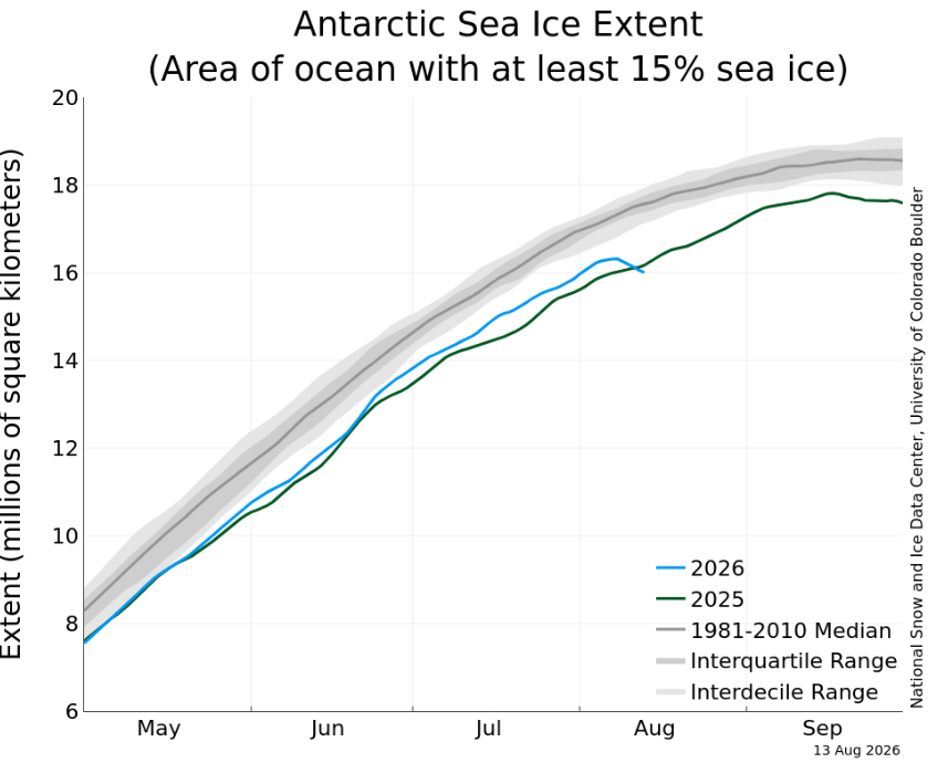
Yeah wow that's weird. Wouldn't a calving event though cause the level to go up, not down? (given that this a measure of sea ice, not land ice) I believe that this measure allows for ice that has broken free but is still within the area of measure. Perhaps a large berg just exited the area being measured, and thus is not longer considered "Antarctic sea ice"?
-
I doubt that
-
Just wait....in a few years they can move back in when they are looking for jobs :-) I have two at home looking for their "Adult" jobs. THe older one had one after graduation but his company was folded into Staples and was laid off. The other graduated in December and is an applied math major sending resumes everywhere. Nice to have them home, but it can be a struggle seeing all they are trying to do and nothing.
-
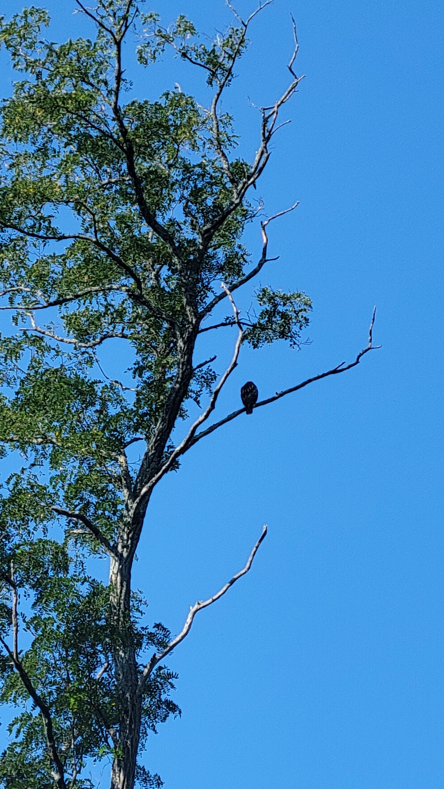
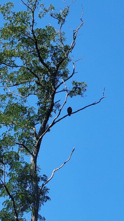
72°/57° . Red tail surveying the woodyard.
-
Randomly it's pouring rain here right now, wasn't expecting that. Not a breeze in sight, it's pretty stagnant out there.
-

2026-2027 Record-breaking El Nino
LakePaste25 replied to Stormchaserchuck1's topic in Weather Forecasting and Discussion
During super ninos, the most favored Great Lakes areas are those that favor NW flow lake effect, e.g. Edinboro/Colt Station/Chautaqua Ridge/S Tug Hill/Syracuse. This is due to the sheer number of coastal storms and even if they are mostly rain, the N stream diving in after can result in NW flow lake enhanced/upslope snow. -

Augdewst 2026: Summer's Last Stand
dendrite replied to Prismshine Productions's topic in New England
Min 55.4° Starting to get too cold. -
My daughter moves into college in about 2 weeks. Will be very weird not having her home.
-
Really need good weather today and tomorrow as I am moving kid #3 into college this weekend after moving kid #2 into college earlier this week. #parentlife I know we have a few empty nesters here but have 2/3 of my kids out of the house is gonna be weird and hard to adjust to for a while. Will be fine over time but man, its a change.
-

Occasional Thoughts on Climate Change
LibertyBell replied to donsutherland1's topic in Climate Change
John it might be a black hole for humans but it will be a Renaissance for the planet as with far fewer humans the planet will be much better off. I'm also not sure it will be a black hole for humanity because we will colonize space and leave this planet. Also it's an interesting analogy for a strictly scientific reason, black holes represent peak entropy in the universe and climate change reduces the differences between the poles and the tropics which also leads to peak entropy on our planet. And black holes might not be the end but only the beginning as several theories point to black holes being the birth place of new universes. -

Central PA Summer 2026 Discussion/Obs Thread
Mount Joy Snowman replied to Voyager's topic in Upstate New York/Pennsylvania
Low of 68. Couple nice days ahead. National high of 113 at Medicine Lodge, KS and low of 35 at Finland, MN. @canderson good luck with your rotator cuff.