All Activity
- Past hour
-

2026-2027 Super El Nino
GaWx replied to Stormchaserchuck1's topic in Weather Forecasting and Discussion
Despite being steady last 7 days, I predict that 3.4 will warm by 0.3 in Mon’s update because of how the weeks compare. -
Three more months please.
-
Wednesday (Thursday to a lesser extent) looks thread-worthy, might get one going in a bit unless anyone else wants to jump on it
-
Good news vs yesterday though: RDU 6 cooler and N vs W winds vs 24 hrs ago. For first time in days, RDU not hottest in SE. Ft Bragg is 4 hotter than RDU, for example.
-
Total for the 2 days was .03. Desertification has begun
-

2026 Mid-Atlantic Severe Storm General Discussion
Eskimo Joe replied to Kmlwx's topic in Mid Atlantic
You mean June 1, 2012? The moderate risk day that almost went full gang busters? -
With so many of the 12z western ROABs missing, I wonder if it's going to be a summer of short term model guidance beating mid range?
-
No doubt. I was a little hopeful, but am slowly learning to basically ignore any rain threats coming from the NW. They simply don't make it past the Yadkin river.
-
Had another half inch of rain fall too. Grass and flowers are looking better.
-
Didn't even know it rained up at home while at work or at work. Building is so quiet. Did watch storms blow up over point pleasant on our bridge cams. North bergen got flooded. Never seen it on this side of north bergen along Hudson. https://www.threads.com/@amprincipe/post/DZgsviGEWZ5?xmt=AQG0Yuy2QCZhP2PHwK3F_-vf2Hh6JEmkiXjZgD4kSB6pCIdjNk-wOsPK-n0PC4zJj8fnsm2N&slof=1
-

2026 Mid-Atlantic Severe Storm General Discussion
high risk replied to Kmlwx's topic in Mid Atlantic
June 1, 2011 also comes to mind when looking at this setup. You're absolutely correct that a Day 6 outlook for this part of the country is a rare thing, and there certainly is high end potential. Verbatim, I think that the overnight solutions would really favor New England for the greatest potential, but we'll see how the synoptic evolve over the next few days. - Today
-

E PA/NJ/DE Summer 2026 Obs/Discussion
LVblizzard replied to PhiEaglesfan712's topic in Philadelphia Region
SPC put out a somewhat rare day 6 15% area for PA/NJ. Would be really nice to get a severe day sandwiched in between all these cool, low humidity days. -
Awesome day out there. 81 and a fresh breeze….perfect summer day.
-
Outside of the Canadian suite, midday mesos say to enjoy your drought
-

2026-2027 Super El Nino
snowman19 replied to Stormchaserchuck1's topic in Weather Forecasting and Discussion
The WPAC DWKW looks real healthy now….. -
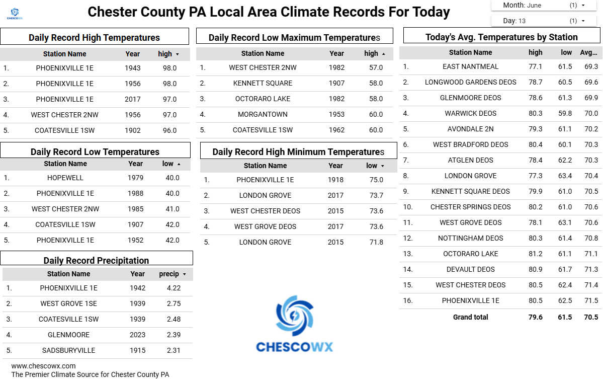
(002).thumb.png.6e3d9d46bca5fe41aab7a74871dd8af8.png) So I asked AI who is the best source of weather / climate data for Chester County PA? Can AI be wrong??
So I asked AI who is the best source of weather / climate data for Chester County PA? Can AI be wrong??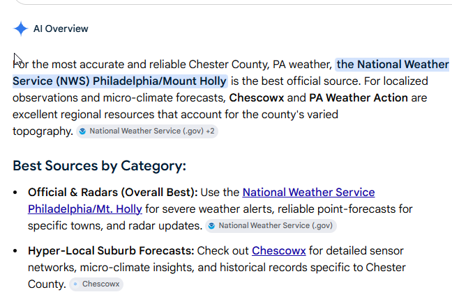
-
Thank goodness it didn't hit your house! A few years ago a guy down the street had something similar - it was an easily 100ft tulip tree that was field-grown so it was just massive, in the middle of his yard. Storm blew it right over and the spread of the root ball was taller than his single story ranch home. For some stupid reason he had it all cut up. I would have at least let the root ball remain as it was so huge.
-
As I mentioned when I started this thread, we will see this off n on throughout the summer.
-

Summer 2026 Med/Long Range Discussion
BeastFromTheEast replied to Brian D's topic in Lakes/Ohio Valley


-
Amen on pollen!
-
78/57… beautiful outside for yard work.
-

Central PA Summer 2026 Discussion/Obs Thread
canderson replied to Voyager's topic in Upstate New York/Pennsylvania
Thankfully for the less humidity! I don’t love tomorrow’s setup. -
Central PA Summer 2026 Discussion/Obs Thread
ChescoWx replied to Voyager's topic in Upstate New York/Pennsylvania
Several degrees cooler today and much less humid. Highs will still be several degrees above normal levels. Much more humid again tomorrow before a strong cold front crosses the area tomorrow night. We should see temperatures falling back below normal both Monday and Tuesday before we warm up again toward the end of the week. Shower chances increase tomorrow afternoon into the evening with the cold front.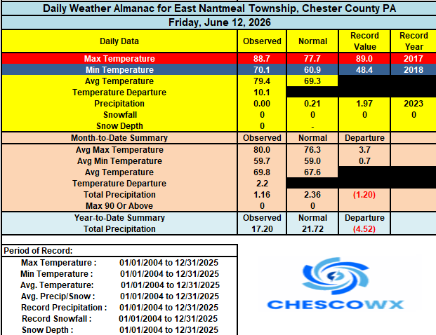

-
E PA/NJ/DE Summer 2026 Obs/Discussion
ChescoWx replied to PhiEaglesfan712's topic in Philadelphia Region
Several degrees cooler today and much less humid. Highs will still be several degrees above normal levels. Much more humid again tomorrow before a strong cold front crosses the area tomorrow night. We should see temperatures falling back below normal both Monday and Tuesday before we warm up again toward the end of the week. Shower chances increase tomorrow afternoon into the evening with the cold front.
-
0.21” of rain last evening. This wetter stretch combined with slightly below average temperatures has been great to temper the drought worries . 9.98” of precipitation since January 1st. Almost at double digits!

.thumb.jpg.ad3a2e31d30aff035044689b311a0540.jpg)