All Activity
- Past hour
-

Richmond Metro/Hampton Roads Area Discussion
wasnow215 replied to RIC Airport's topic in Mid Atlantic
I'm reading this wrong?-it looks like he has RVA in "A" -
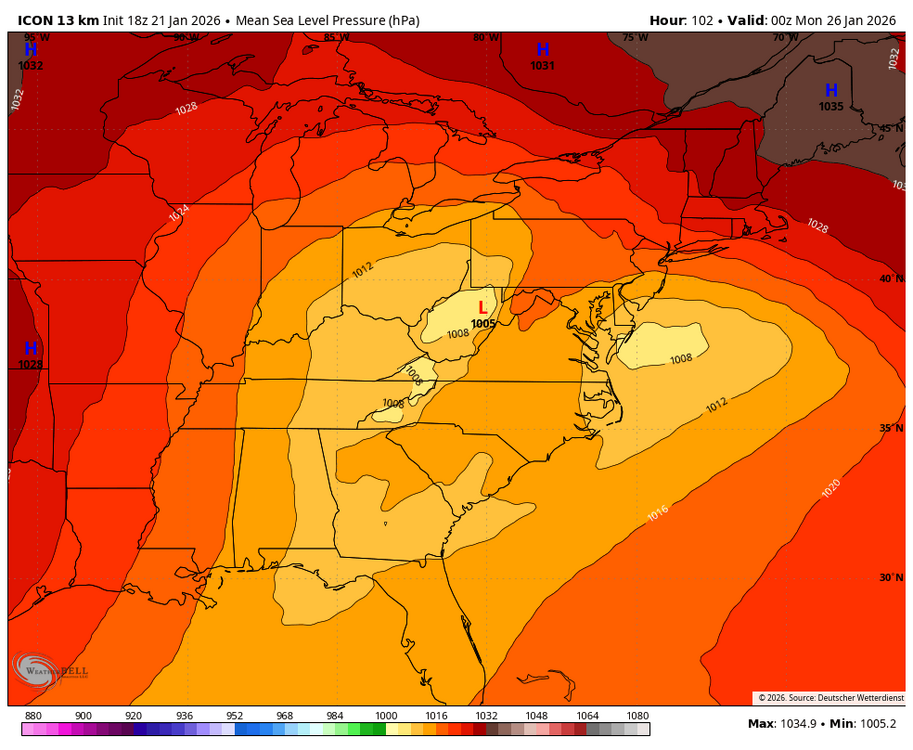
When the measly ICON is northwest, bombs away
-

Pittsburgh/Western PA WINTER ‘25/‘26
MikeB_01 replied to Burghblizz's topic in Upstate New York/Pennsylvania
no more north please.
-
Icon basically has a perfect, full phase of the northern stream and the Baja low. It’s textbook. We’ve only seen that on like 1-2 runs of varsity models yet for this storm? Seems pretty unlikely with how much is going on. I’ll take 6” and taint as the fail scenario.
-
My gut says north of I-85 and west of the triangle is a sleet fest of epic proportions and that’ll start showing itself in short range guidance tomorrow and Friday.
-

January 24-26: Miracle or Mirage JV/Banter Thread!
Kmlwx replied to SnowenOutThere's topic in Mid Atlantic
Ya'll are so predictable...just saying -
The 850 LP is what's wrecking thermals the most..surface LP is only a smaller pct of problem
-
Mein leiblingswettermodell, das ICON, ist NW
-
 euro AI is the best model of all! follow that and it'll lead you to the real solution in my opinion
 -

Possible Record Breaking Cold + Snow Sunday 1/25 - Tuesday 1/27
NEG NAO replied to TriPol's topic in New York City Metro
thats why I posted this little gem of a link - Snow and ice storm, March 4-6, 2001 - Storm Summary mass hysteria - all milk and bread sold out for next to nothing in accumulation -
Can’t see the model right now…was it an improvement over 12z?
-

Pittsburgh/Western PA WINTER ‘25/‘26
Rd9108 replied to Burghblizz's topic in Upstate New York/Pennsylvania
That's about as far north as you want this. Ill be curious to see if this trend continues. Southeast weenies already jumped ship, mid Atlantic are holding on for dear life. -

January 24-26: Miracle or Mirage JV/Banter Thread!
Maestrobjwa replied to SnowenOutThere's topic in Mid Atlantic
I'm telling ya man...if the others follow suit it'll be the worst rug pull in 10 years as we were are so close! -
Deleted. I screwed it up i think but that point still stands lol
-

Possible Record Breaking Cold + Snow Sunday 1/25 - Tuesday 1/27
weatherpruf replied to TriPol's topic in New York City Metro
so what model would you consider the best, knowing of course that none of them are perfect...there was a met the other day that said this would not come north...lol -
You’re forgetting about our 100+ hr lake effect plume which always verifies
-

Winter 2025-26 Short Range Discussion
michsnowfreak replied to SchaumburgStormer's topic in Lakes/Ohio Valley
Over the past 20 years, Detroit has averaged 6.8" more annual snowfall and 5 more annual 1"+ snowcover days despite a DJF avg temp 1.3° warmer than Chicago. Obviously it isn't a huge difference, and it shouldn't be with the two places latitude and proximity. But the same thing goes for big dogs. It isnt like Chicago gets one every winter. Other than those few, the overall snowstorm climo is also quite similar. -
Miller B
-

MO/KS/AR/OK 2025-2026 Winter Discussion
JoMo replied to stormdragonwx's topic in Central/Western States
Springfield with the somewhat useless AFD this afternoon. 18z ICON has a 20" Kuchera amount IMBY. 18z NAM was faster with kicking the system out compared to the other models and had more WAA precip farther south with the initial precip. 18z RDPS looked similar to it's 12z run. -
I am posting Weeklies maps for weeks 3-6. EPO ridge. NAO block. AN heights over Alaska. Are we watching winter hit and hold in the East? Maybe so. When you go back and look at -QBOs, you will quite regularly find some excellent winters. If this map holds, winter is just getting started. The Euro mean buries the forum. Precip is normal over E TN. There will be some talk that this is a Nino pattern. I don't think so. The core of BN temps is over the NE/MA and not SE. Don't use up all of your mental fuel with this weekend...we may have to pace ourselves this winter. January is well on track to now finishing BN or temps. Take a look at the 12z GEM-para if you have it....
-
Tomorrow will be the warmest day of the week with highs reaching or surpassing 40°. However, the mild temperatures will be shortlived. An even colder Arctic front will cross the region on Thursday, possibly with some snow flurries or snow showers. A frigid weekend lies ahead. Snow could arrive on Sunday. A significant snowfall is possible in and around the New York City area and surrounding region, even if a transition to sleet could occur at some point during the storm. The last time New York City saw a 6" or greater snowfall was January 28-29, 2022 when 8.3" fell. Its last 10" or above snowfall occurred during January 31-February 3, 2021 when 17.4" accumulated. There remains uncertainty and it may still be another day or two before the details can be pinned down with high confidence. The temperature will likely stay below 20° in New York City and much of the region on Saturday. The last time that happened in New York City was January 21, 2025 when the high was 19°. Overall, January 20th-February 3rd will likely be the coldest and perhaps snowiest two-week period this winter. The forecast WPO-/EPO-/AO-/PNA+ pattern is typically the coldest pattern in January and among the coldest during the first half of February. A persistently positive PNA will have above climatological risk of moderate or significant snowfalls. For perspective, the coldest two-week period this winter prior to January 20th was January 3-16, 2026 and January 4-17, 2026 with a mean temperature of 30.3°. The snowiest two-week period was December 14-27, 2025 when 7.2" of snow fell. The ENSO Region 1+2 anomaly was -0.3°C and the Region 3.4 anomaly was -0.7°C for the week centered around January 14. For the past six weeks, the ENSO Region 1+2 anomaly has averaged -0.48°C and the ENSO Region 3.4 anomaly has averaged -0.68°C. La Niña conditions will likely continue into at least late winter. The SOI was +7.54 today. The preliminary Arctic Oscillation (AO) was -2.334 today. Based on sensitivity analysis applied to the latest guidance, there is an implied near 98% probability that New York City will have a cooler than normal January (1991-2020 normal). January will likely finish with a mean temperature near 30.7° (3.0° below normal). Supplemental Information: The projected mean would be 1.9° below the 1981-2010 normal monthly value.
-
Just so you know the pivotal beta gifs are broken. The old display works better for them. I don’t see 18z in that gif
-
Possible Record Breaking Cold + Snow Sunday 1/25 - Tuesday 1/27
weatherpruf replied to TriPol's topic in New York City Metro
does that really mean anything either....this is days away; best we can say is there is some weather ahead. that's all. be prepared either way. it does not hurt to be prepared. -
WB 18Z ICON takes a primary into northern WV, transfer is north of us and we basically get dry slotted.