All Activity
- Past hour
-

Southern Crippler - Get well soon Jimbo Storm Obs
olafminesaw replied to BooneWX's topic in Southeastern States
HRRR showing low 20s in the triad as that band of heavy ZR comes through this evening. Pretty extreme stuff -

Pittsburgh/Western PA WINTER ‘25/‘26
blackngoldrules replied to Burghblizz's topic in Upstate New York/Pennsylvania
Yep. Heavy snow. -
-

Southern Crippler - Get well soon Jimbo Storm Obs
SUNYGRAD replied to BooneWX's topic in Southeastern States
Moderate sleet here in Winston Salem at 10:20. -

Extreme Cold, Snow & Sleet: SECS 1/24 - 1/26
binbisso replied to TriPol's topic in New York City Metro
Just under 4" at 10am. Snowing moderately now should hit 10" here -

Arctic Hounds Unleashed: Long Duration Late January Cold Snap
dendrite replied to WxWatcher007's topic in New England
My new combustion blower fan for the pellet stove that I got 2 weeks ago is already getting noisy. Apparently it doesn’t like running on high. -

Pittsburgh/Western PA WINTER ‘25/‘26
MikeB_01 replied to Burghblizz's topic in Upstate New York/Pennsylvania
puking snow in bethel. Absolutely ripping -
 Yesterday was brutal. Made the mistake of stubbornly running on glaciated sidewalks instead of just doing small loops around the town center. Plan is for 40 minutes of easy around noon and another 40 minutes later in the evening after pats… I always overtrain during storms!
 -
Moving quickly

-

MO/KS/AR/OK 2025-2026 Winter Discussion
rockchalk83 replied to stormdragonwx's topic in Central/Western States
We finished with 7" officially at Eisenhower National Airport (ICT). I measured 7.5" outside of my house. Not the 12-20" that were progged Thursday night, but still a solid storm system with much needed moisture. -
(002).thumb.png.6e3d9d46bca5fe41aab7a74871dd8af8.png)
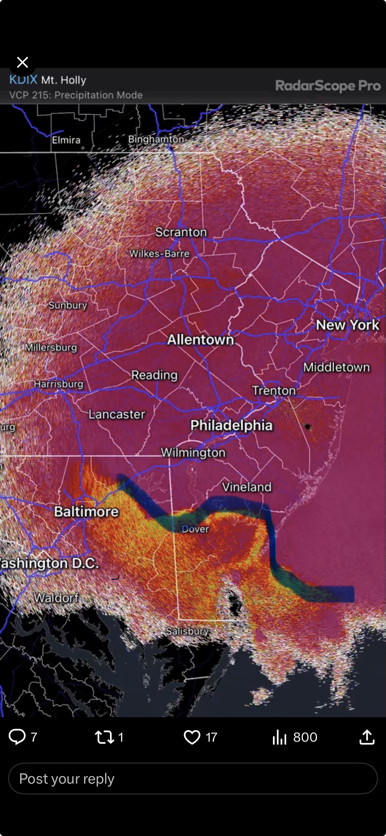
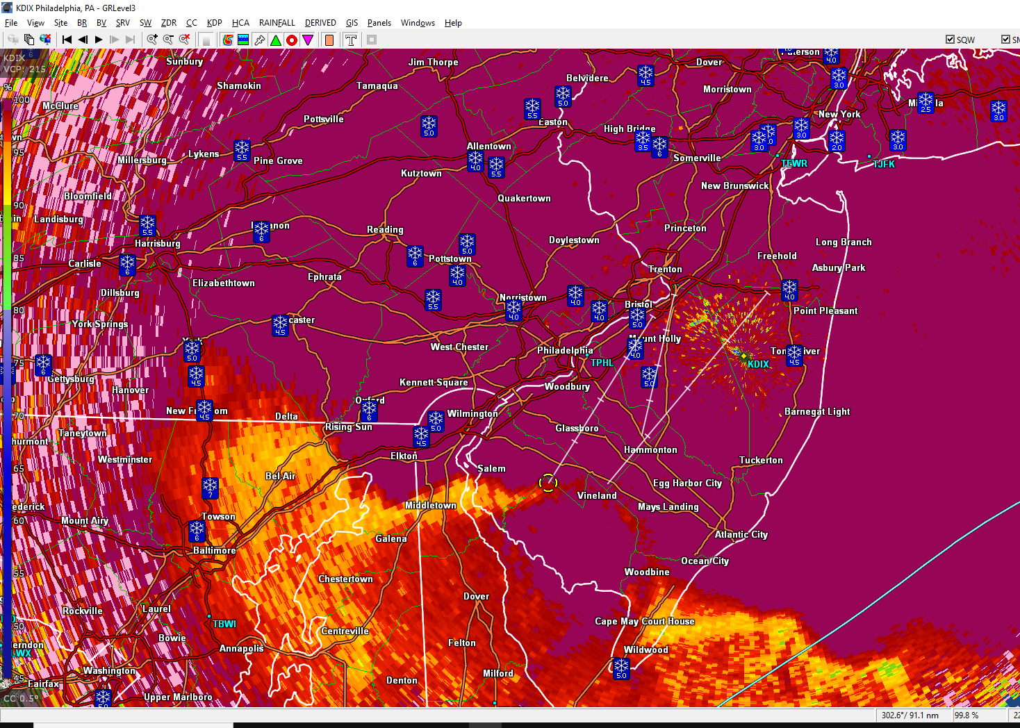
January 25-26 Winter Storm Potential
ChescoWx replied to Ralph Wiggum's topic in Philadelphia Region
Mix line just touching SW Chesco...while still snow in Sea Isle City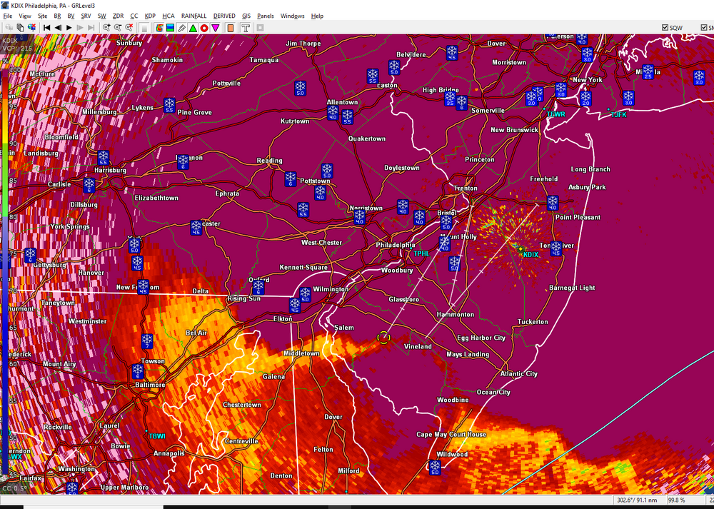
-
Heavy snow on the rockland/bergen border, visibility less than 500’.
-

Pittsburgh/Western PA WINTER ‘25/‘26
Rd9108 replied to Burghblizz's topic in Upstate New York/Pennsylvania
People south of the city. Still snow? -

January 24-26: Miracle or Mirage OBS Thread!
IUsedToHateCold replied to Jebman's topic in Mid Atlantic
Noting the same here. I've had my eyes out the window constantly for the past half hour and during heavier bursts it switches to mostly snow briefly before going back to sleet. There is a fair amount of snow when you put it all together, going to be interesting to measure later -

Pittsburgh/Western PA WINTER ‘25/‘26
Burghblizz replied to Burghblizz's topic in Upstate New York/Pennsylvania
Pounding here and up to 8”. -

January 25-26 Winter Storm Potential
donsutherland1 replied to Ralph Wiggum's topic in Philadelphia Region
Sorry about the delay, as I was away from the site. https://www.weather.gov/wrh/TextProduct?product=pnsphi -

Southern MD / Lower Eastern Shore weather discussion
Lowershoresadness replied to PrinceFrederickWx's topic in Mid Atlantic
damn that warmth will not be denied. jumped 5 degrees in a half hour. how icy will the am be tomorrow? -
 See, nothing like Mar 17. You melted for nothing. Still think we end up in the neighborhood of ~12"
 -
0.4" of (mostly) sleet last hour (seems like a lot!). 6.9" total snow+sleet. eta...need another 0.4" to mark my 3rd biggest snowstorm in 11 winters in this house. Top 2 (Jan 2016 and Jan 2019) are safe.
-
Would expect it to get increasingly foggy this afternoon as temperatures rise to mid-high 20s with sleet transitioning to freezing drizzle, ice accretions should be fairly minimal, then later this evening and overnight a colder trend returns and snow grains will start to fall mixed with light sleet, before snow flurries in 10-15 F temps by morning. A further inch of snow could accumulate eventually on top of a frozen slush. This will not apply to parts of DE and se MD where temps will rise to near 40 F and straight rain will fall for a brief interval.
-

January 25-26 Winter Storm Potential
Mikeymac5306 replied to Ralph Wiggum's topic in Philadelphia Region
I'm going off this number in Exton as well. Rt 100 is a mess. I was lucky to follow a plow train taking my son to work. -
 Heavy rain and 34 degrees in Lenoir City...trees are icy. Power loss at 4:00 am until after 6:00 am.
 -

Central PA Winter 25/26 Discussion and Obs
Jns2183 replied to MAG5035's topic in Upstate New York/Pennsylvania
It also went back and forth forth for a couple hours after first pingers 1" last 30 min 7.75' Sent from my SM-S731U using Tapatalk -

Central PA Winter 25/26 Discussion and Obs
Jonesy56 replied to MAG5035's topic in Upstate New York/Pennsylvania
Good morning all! Beautiful rippage here in Lingletown with 1 inch/hr plus rates currently! This is what we all wait for!! On the downside, the 3km NAM is once again winning the ground truth war on advance of the sleet line and even running behind. Heading out with the pup to maximize the enjoyment and hoping for the best. Good luck all! . -

Pittsburgh/Western PA WINTER ‘25/‘26
Mailman replied to Burghblizz's topic in Upstate New York/Pennsylvania
Still snow here.