All Activity
- Past hour
-

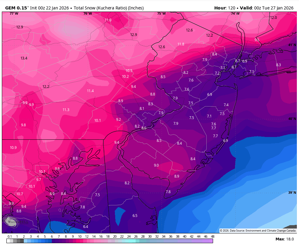
January 25-26 Winter Storm Potential
Violentweatherfan replied to Ralph Wiggum's topic in Philadelphia Region
The redevelopment of the low, if any will be key -
-

Possible Record Breaking Cold + Snow Sunday 1/25 - Tuesday 1/27
EastonSN+ replied to TriPol's topic in New York City Metro
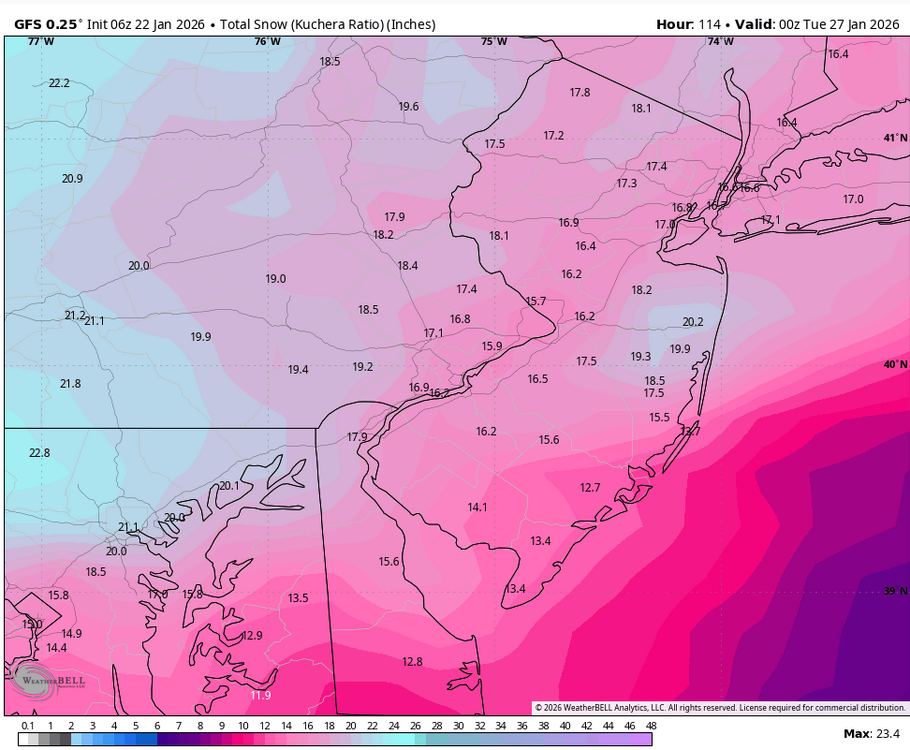
So far 6z EURO held EURO AI nudged south and colder. GFS looked amazing but not waisting much time on it. -

January 24-26: Miracle or Mirage JV/Banter Thread!
Mrs.J replied to SnowenOutThere's topic in Mid Atlantic
With the watches going up overnight it hit me this morning that this is the first real biting storm with both of the girls not here. One in Southern PA on campus and the other in DC off campus. My mom mind kicked in and have been talking with both of them this morning about what to have on hand. Rightfully so the DC kid brought up the possibility of loosing power. And for that matter I also told the PA kid that could be a possibility. -

January 24-26: Miracle or Mirage JV/Banter Thread!
WVclimo replied to SnowenOutThere's topic in Mid Atlantic
Mine is good for 3 feet, but there’s room for more if needed. The solar light on top was an addition this year. Good for seeing depth at night from the window.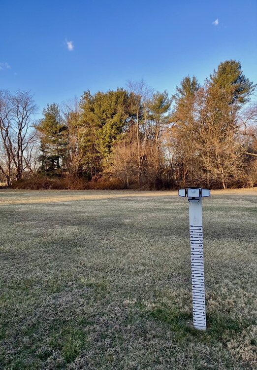
-

January 24-26: Miracle or Mirage JV/Banter Thread!
Interstate replied to SnowenOutThere's topic in Mid Atlantic
Lazy... You drinking your coffee in the warmth of your home... while we have to bundle up to check our measurements with a wood stick. -
WRAL's first forecast with numbers is exactly the Euro.

-

Let’s talk winter!! Ohio and surrounding states!! 24'-25'
buckeye replied to buckeye's topic in Lakes/Ohio Valley
long time no read my friend.... hopefully we can score this -

1/24-1/25 Major Winter Storm - S. IL, IN, MI and OH
Cary67 replied to A-L-E-K's topic in Lakes/Ohio Valley
Was that the downtown lake effect special? -
That seems aggressive.
-
Watching the The Weather Channel this morning (don't berate me for that) they said that planes (hurricane hunter type) are going to where the LP is off the coast of CA and also to the Gulf of America to collect high resolution data that will feed the models. My question to you guru's is how might that information affect the models?
-
I know one thing for sure after this last week. Models can’t be trusted for anything other than a threat detection more than 3 days out. Heck, we’re under 3 days and it’s still a bit up in the air. Other lesson learned. Don’t listen to folks saying that there’s “no way that low can cut up through that strong high pressure”.
-
(002).thumb.png.6e3d9d46bca5fe41aab7a74871dd8af8.png)
January 25-26 Winter Storm Potential
ChescoWx replied to Ralph Wiggum's topic in Philadelphia Region

-

Let’s talk winter!! Ohio and surrounding states!! 24'-25'
dilly84 replied to buckeye's topic in Lakes/Ohio Valley
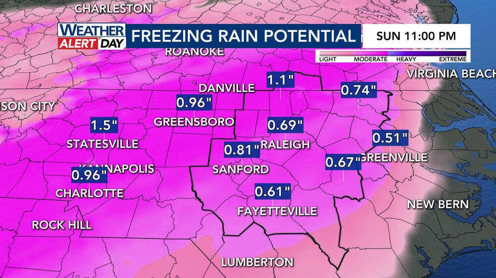
Im opposite. Im more concerned it keeps pushing nw until we get freezing rain/sleet lol. -
My wife just reminded me that I posted this on Facebook 10 years ago today. I guess history does repeat itself…… .
-
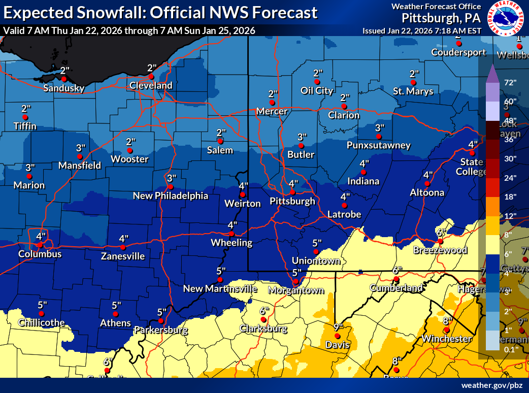
2"
-
Do the Euro
-
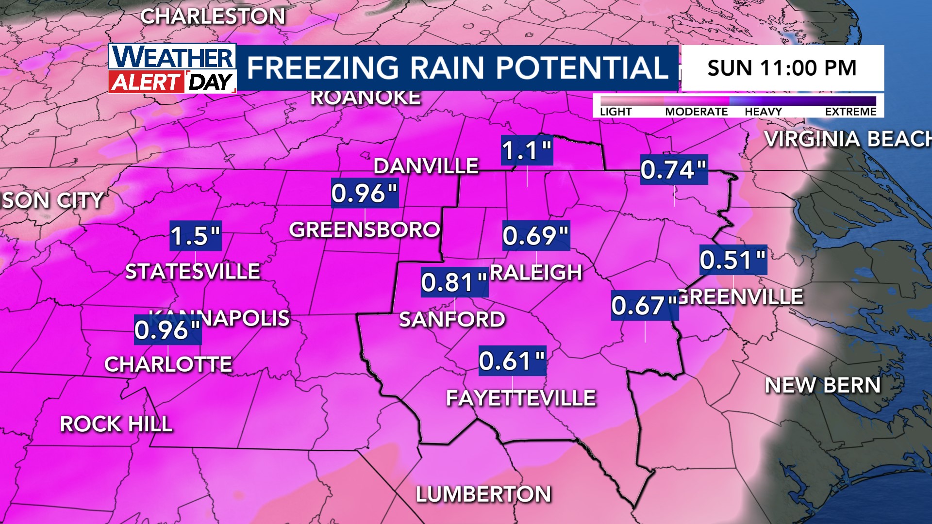
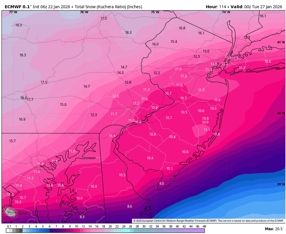
 I'm looking at trends. Outside of the flatter GFS which is a garbage model lets be honest and a follower more than a leader, most other models are starting to introduce a warm layer that cuts down on totals somewhat and this might not be done trending, that SE Ridge often times plays a factor. Regardless, the floor looks to be a significant snow before any changeover so it's not a bad place to be.
 -
At least 1.3” here yesterday into today. More coming.
-
I could tell you what its Critical Success Index value for 24h snowfall at Day 3 is, but what would you do with that number? For the most part, it’s as good as the inputs it uses, but the operational version right now is running high, because it’s bias correcting QPF upward based on a very limited sample of recent significant QPF events in the very dry Mid-Atlantic.
-
Possible Record Breaking Cold + Snow Sunday 1/25 - Tuesday 1/27
EastonSN+ replied to TriPol's topic in New York City Metro
Also yesterday Forky said he's not worried. Until/if Forky amends his statement. -

Possible Record Breaking Cold + Snow Sunday 1/25 - Tuesday 1/27
NEG NAO replied to TriPol's topic in New York City Metro
only when the high to the north is NOT as strong and anchored like this weekends will be - this is a Miller B setup redevelopment off the coast sooner then later -

Pittsburgh/Western PA WINTER ‘25/‘26
colonel717 replied to Burghblizz's topic in Upstate New York/Pennsylvania

-
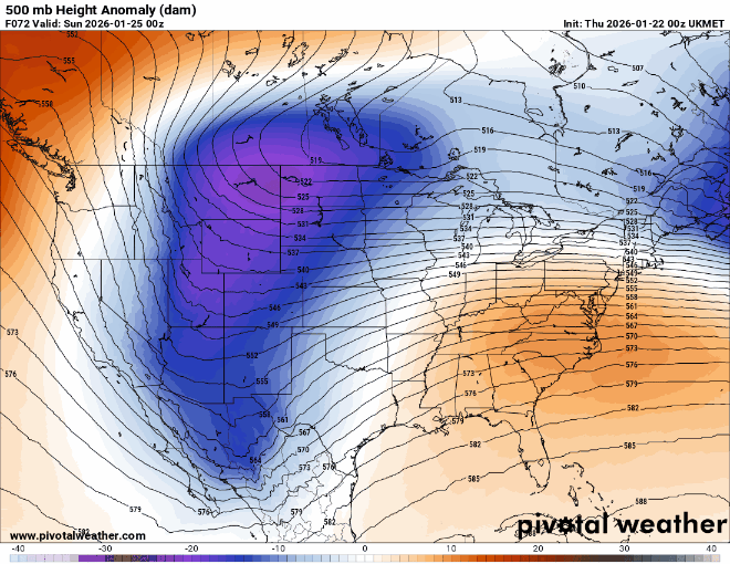
Looking at the 6z Ukie, it's a little cooler at 66hrs than 0z at 72hrs thanks to some better confluence. May be a tad slower. Cooler is probably likely since ensembles responded.
-

January 24-26: Miracle or Mirage Thread 2
SomeguyfromTakomaPark replied to mappy's topic in Mid Atlantic
Too early for this I know and the mesos will do better but the soundings for DCA on the Euro look like heavily rimed snow to me for a lot of Sunday when we're under pink, only later on Sunday is it a clear ice sounding.