All Activity
- Past hour
-

Central PA Spring 2026 Discussion/Obs Thread
Superstorm replied to Voyager's topic in Upstate New York/Pennsylvania
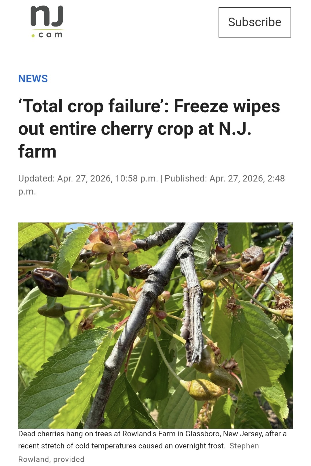
WGAL report on crop damage due to freeze.... https://www.facebook.com/watch/?v=1349543337094583 -
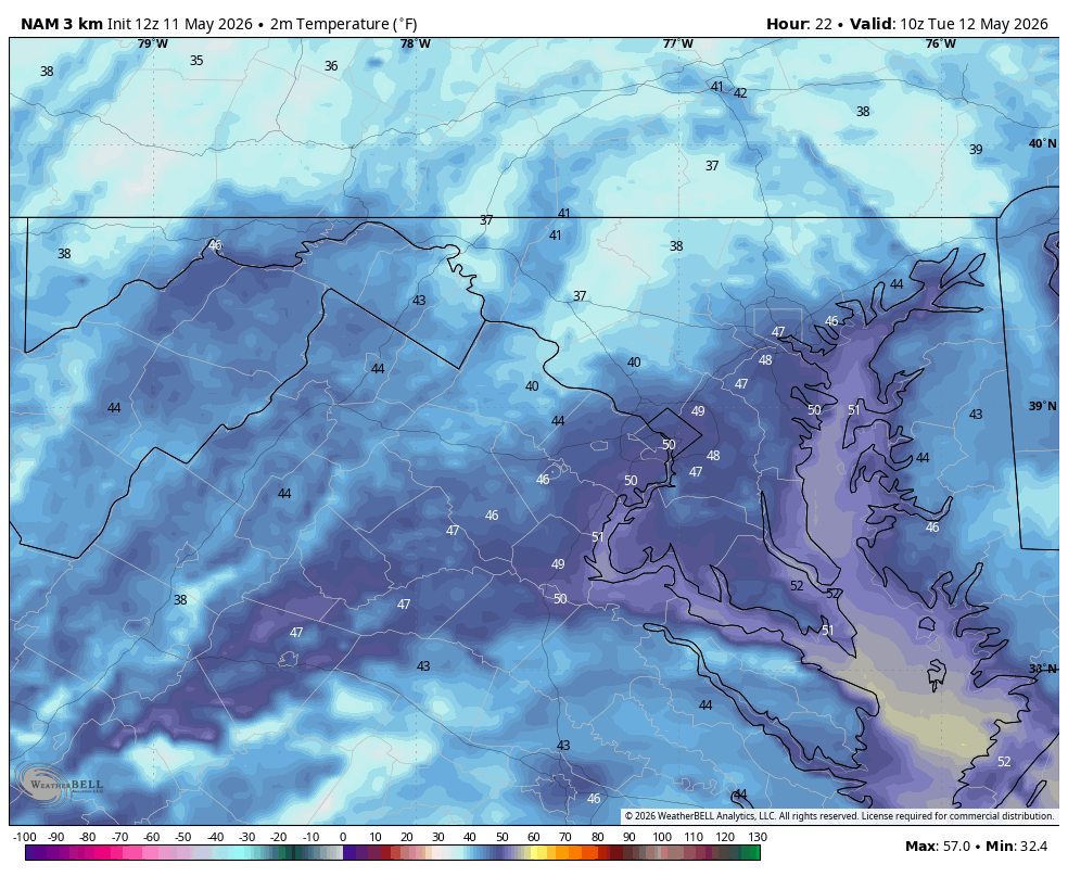
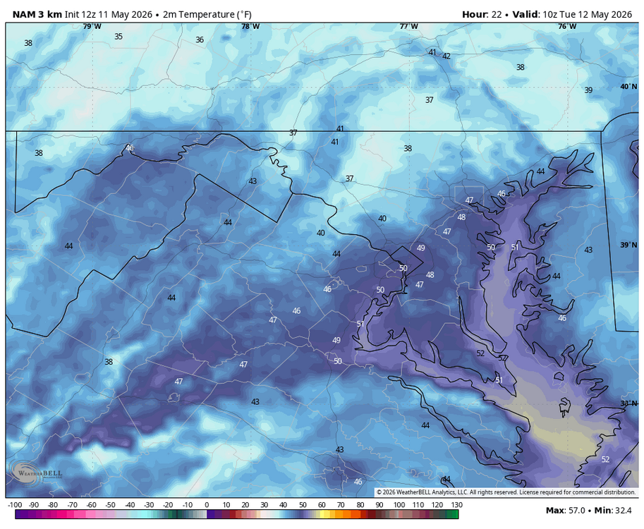
WB 12Z 3K NAM for tomorrow am.
-
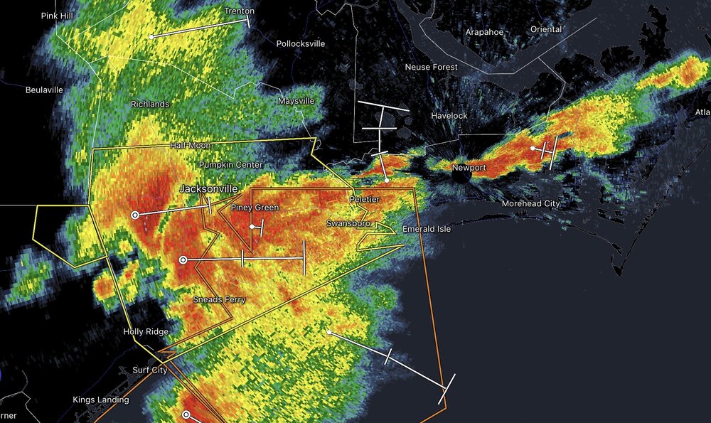
Gnarly line coming through Jacksonville, NC
-

E PA/NJ/DE Spring 2026 Obs/Discussion
RedSky replied to PhiEaglesfan712's topic in Philadelphia Region
56F and overcast not a bad day for late March oh wait -
The 3/4-1.5sm -SN is probably one of the more over-stated weather obs by all. I mean, it can be 1”/hr though too with even decent snow growth at 3/4-1sm. So sometimes hard to fault folks. I will say if any of us started seeing 1.5sm vis -SN right now we’d say it was ripping out, lol. When you haven’t seen snow in a while, a mile and a half is a steady snowfall.
-
We got 1/2” last night. That’s better than nothing. Just enough to keep everything slightly green & surviving.
-
-
Maybe we can try sneaking in an EML ~next Tuesday
-

E PA/NJ/DE Spring 2026 Obs/Discussion
JTA66 replied to PhiEaglesfan712's topic in Philadelphia Region
Had to move the decimal point one spot over to the left after yesterday's "rain"...0.02". Wasn't this supposed to be our "wet period"? Man, drought guy's head is going to explode. On a positive note, May is the last full month we add daylight. Patience! -

Central PA Spring 2026 Discussion/Obs Thread
Jns2183 replied to Voyager's topic in Upstate New York/Pennsylvania
I've been reading up on some old time weather events around this area. Anyone know where I can get some more information regarding the August 22, 1915 Hanover tornado? Seems like it was probably part of line, and was more likely than not high end EF-2/low end EF-3 that went straight through downtown. Apparently gloves from the glove factory were found many many miles away. I pulled up the reanalysis maps and it was definitely a high shear low cape. Seemed like Harrisburg area got firehosed picking up 4"-5" of rain Sent from my SM-S731U using Tapatalk -
I honestly want it to be warm and humid for the next 6 months. I’m so over the weather we’ve had since the pattern flip last September. It’s cloudy 4-5 days a week with very little to show for it. Let’s get swamp weather and rebuild the water table.
-

E PA/NJ/DE Spring 2026 Obs/Discussion
BBasile replied to PhiEaglesfan712's topic in Philadelphia Region
Picked up 0.24" of rain. Nowhere near enough, but we'll take it! -
I know when to get excited. I definitely would not say ripping at S-.....but Ineedsnow will.
-
E PA/NJ/DE Spring 2026 Obs/Discussion
BBasile replied to PhiEaglesfan712's topic in Philadelphia Region
Same down here. Sucks.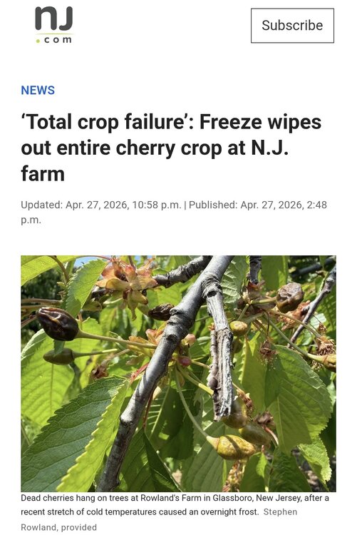
-
Well, is this any different that CoastalWx having a PT for "MASSIVE DENDRITES" when "WE SNOW?" It will be 3/4S-, and we will get "RIPPING!"
-
Came through with a bite in Raleigh. Immediate wind change to north and gusts that definitely topped 30
-

Occasional Thoughts on Climate Change
TheClimateChanger replied to donsutherland1's topic in Climate Change
-

Central PA Spring 2026 Discussion/Obs Thread
WmsptWx replied to Voyager's topic in Upstate New York/Pennsylvania
Holy Christ, this place is dead. - Today
-
Occasional Thoughts on Climate Change
TheClimateChanger replied to donsutherland1's topic in Climate Change
What are you talking about? Nobody is "having a discussion with AI"... I use it for assistance in creating an engaging headline, that's all. As Don pointed out, there is, in fact, evidence that it is better at that than a human. And I can say from my personal analytics, that this is certainly the case. -
I mean I don’t love the punishing humidity but my skin certainly does better with more humidity than we’ve had.
-
2015 # of 90 degree 2015: PHL: 37 (Apr: 0 ; May: 1; Jun: 7; Jul: 10; Aug: 12; Sep: 7 EWR: 35 (Apr: 0 ; May: 2; Jun 4; Jul: 11; Aug: 13; Sep: 5 TTN: 27 (Apr: 0 ; May: 2; Jun: 4; Jul: 6; Aug: 9; Sep: 6 LGA: 20 (Apr: 0 ; May: 0 ; Jun:3; Jul : 6; Aug: 8; Sep: 3 ACY: 21 (Apr: 0 ; May: 0 ; Jun: 5; Jul: 4; Aug: 8; Sep: 3 TEB: 38 (Apr: 0 ; May: 4 ; Jun : 5; Jul: 8; Aug: 12; Sep: 8 NYC: 20 (Apr: 0 ; May: 0 ; Jun: 1; Jul: 5 ; Aug: 8; Sep: 6 JFK: 12 (Apr: 0 ; May: 0 ; Jun: 1; Jul:3 ; Aug: 6; Sep: 2 ISP: 7 (Apr: 0 ; May: 0 ; Jun: 0 ; Jul: 3 ; Aug: 2; Sep: 2 New Brunswick: 36 (Apr: 0 ; May: 2 ; Jun: 3; Jul: 11; Aug: 14; Sep: 6 89 Degree Days: TEB: 7 TTN: 4 PHL: 10 New Brunswick: 10 EWR: 6 NYC: 8 ACY: 9 JFK: 9 LGA: 7 ISP: 2 The year/summer was warm ad had the record for most 80 or >80 degree days in many spots. or top 3 in most others.
-
Projections for this year EWR: 30 - 35 NYC: 21 - 26 LGA: 26 - 30 JFK: 17
-
hey bluewave how was the 2015 summer? was it hot, average or cooler than normal?
-
There definitely is some support for the typical torch spots to hit 90
-

2026 Mid-Atlantic Severe Storm General Discussion
high risk replied to Kmlwx's topic in Mid Atlantic
We know that if a rising parcel is much warmer than its environment (implying large CAPE), it will accelerate more and create intense updrafts. The same concept in reverse is true for a downdraft. If the sinking parcel is much colder than its environment, it will accelerate downward, leading to a more intense downdraft. The area between the path of the rising parcel and its environment is CAPE; the area between the path of the sinking parcel and its environment is DCAPE. You can find a nice slide deck at https://www.weather.gov/media/lmk/soo/DCAPE_Web.pdf