All Activity
- Past hour
-
Northern Kentucky and Ohio are having a banner Winter. They had the long snowless break late December and early January but cashed in with 3 4+ Event's in early December along with 3 1-3" deal's. Now a foot or so from this one. Cincinnatis Seasonal Average is just over 20 inches. So, after this storm they'll already be a foot above Average.
-

2025-2026 Fall/Winter Mountain Thread
franklin NCwx replied to Buckethead's topic in Southeastern States
Unfortunately, it does. Really pulling for the warm nose on this one -
A widespread 10+ feels likely, and that’s cool to me.
-
Winter Storm Warning URGENT - WINTER WEATHER MESSAGE National Weather Service Little Rock AR 1011 AM CST Thu Jan 22 2026 ARZ004>008-014>017-024-025-031>034-039-042>047-052>057-062>069-103- 112-113-121>123-130-137-138-140-141-203-212-213-221>223-230-237-238- 240-241-313-340-341-231200- /O.UPG.KLZK.WS.A.0001.260123T1800Z-260125T1200Z/ /O.NEW.KLZK.WS.W.0001.260123T1800Z-260126T0000Z/ Marion-Baxter-Fulton-Sharp-Randolph-Stone-Izard-Independence- Lawrence-Cleburne-Jackson-Conway-Faulkner-White-Woodruff-Perry- Garland-Saline-Pulaski-Lonoke-Prairie-Monroe-Pike-Clark-Hot Spring-Grant-Jefferson-Arkansas-Dallas-Cleveland-Lincoln-Desha- Ouachita-Calhoun-Bradley-Drew-Boone County Except Southwest- Newton County Higher Elevations-Searcy County Lower Elevations- Southern Johnson County-Southern Pope County-Southeast Van Buren County-Western and Northern Logan County-Northern Scott County- Northwest Yell County-Polk County Lower Elevations-Central and Eastern Montgomery County-Boone County Higher Elevations-Newton County Lower Elevations-Northwest Searcy County Higher Elevations- Johnson County Higher Elevations-Pope County Higher Elevations- Van Buren County Higher Elevations-Southern and Eastern Logan County-Central and Southern Scott County-Yell Excluding Northwest- Northern Polk County Higher Elevations-Northern Montgomery County Higher Elevations-Eastern, Central, and Southern Searcy County Higher Elevations-Southeast Polk County Higher Elevations- Southwest Montgomery County Higher Elevations- Including the cities of Nogo, Waldron, Clarksville, Mansfield, Western Grove, Marshall, Oark, Benton, Conway, De Valls Bluff, Ola, Hartley, Acorn, Lonoke, Little Rock, Scotland, Pine Bluff, Hampton, Attica, Cherokee Village, Russellville, Kingsland, McGehee, Oxford, Augusta, Cave City, Mountain View, Mammoth Spring, Sheridan, Warren, Des Arc, Plainview, Hatfield, Botkinburg, Coal Hill, Dardanelle, Heber Springs, Bull Shoals, Norman, Pindall, Arbaugh, Mountain Home, Calico Rock, Harrison, Hardy, Beebe, Rich Mountain, Melbourne, Dennard, Mountain Fork, Paris, Ozone, McCrory, Arkadelphia, Morrilton, Rison, Caulksville, Waveland, Monticello, Hector, Stuttgart, Bryant, Murfreesboro, Searcy, Subiaco, Flippin, Nunley, Mount Ida, Grannis, Ponca, Star City, Y City, Clinton, Gould, Camden, Shirley, Boxley, Walnut Ridge, Mena, Yellville, Atkins, Big Fork, Saint Joe, Clarendon, Gilbert, Havana, Pocahontas, Tilly, Cotton Plant, Blue Mountain, Story, Malvern, Horseshoe Bend, Batesville, Hot Springs, Damascus, Dumas, Cabot, Thornton, Newport, De Witt, Hoxie, Hartman, Leslie, Fordyce, Knoxville, London, Danville, Perryville, Deer, North Little Rock, Ash Flat, Sugar Grove, Brinkley, Pelsor, Mount Magazine, Summit, Boles, Jasper, Fairfield Bay, Albert, Booneville, Hazen, and Glenwood 1011 AM CST Thu Jan 22 2026 ...WINTER STORM WARNING IN EFFECT FROM NOON FRIDAY TO 6 PM CST SUNDAY... * WHAT...Heavy mixed precipitation expected. Total snow and some sleet accumulations between 4 and 10 inches across northern sections...sleet and some snow accumulation of 1 to 4 inches over central sections...and sleet and ice accumulations around one to three quarters of an inch across far southern and southeast sections. * WHERE...Portions of central, eastern, north central, southeast, southwest, and western Arkansas. * WHEN...From noon Friday to 6 PM CST Sunday. * IMPACTS...Roads, and especially bridges and overpasses, will likely become slick and hazardous. Expect power outages and tree damage due to the ice. Travel could be impossible. The hazardous conditions could impact the Friday evening commute. PRECAUTIONARY/PREPAREDNESS ACTIONS... If you must travel, keep an extra flashlight, food, and water in your vehicle in case of an emergency. The latest road conditions across Arkansas can be found at www.idrivearkansas.com. && $$ Extreme Cold Watch URGENT - WEATHER MESSAGE National Weather Service Little Rock AR 553 AM CST Thu Jan 22 2026 ARZ007-008-016-017-024-025-031>034-039-042>047-052>057-062>069- 121>123-130-137-138-140-141-230-237-238-240-241-340-341-222200- /O.CAN.KLZK.FG.Y.0004.000000T0000Z-260122T1400Z/ /O.CON.KLZK.EC.A.0001.260124T0600Z-260126T1800Z/ Sharp-Randolph-Independence-Lawrence-Cleburne-Jackson-Conway- Faulkner-White-Woodruff-Perry-Garland-Saline-Pulaski-Lonoke- Prairie-Monroe-Pike-Clark-Hot Spring-Grant-Jefferson-Arkansas- Dallas-Cleveland-Lincoln-Desha-Ouachita-Calhoun-Bradley-Drew- Southern Johnson County-Southern Pope County-Southeast Van Buren County-Western and Northern Logan County-Northern Scott County- Northwest Yell County-Polk County Lower Elevations-Central and Eastern Montgomery County-Southern and Eastern Logan County- Central and Southern Scott County-Yell Excluding Northwest- Northern Polk County Higher Elevations-Northern Montgomery County Higher Elevations-Southeast Polk County Higher Elevations- Southwest Montgomery County Higher Elevations- Including the cities of Little Rock, Rich Mountain, Gould, Newport, Hatfield, Nunley, Thornton, Albert, Batesville, Hazen, Augusta, Clarksville, Monticello, Coal Hill, Sheridan, Hector, Dumas, Y City, North Little Rock, Fordyce, McCrory, Murfreesboro, Bryant, Knoxville, Cotton Plant, Mena, Hoxie, Warren, Scotland, Lonoke, Clarendon, Walnut Ridge, Hampton, Hartman, Pine Bluff, Conway, Norman, Subiaco, De Witt, Danville, Star City, Waldron, Hot Springs, Clinton, Des Arc, Waveland, Mountain Fork, Mansfield, Hartley, Blue Mountain, Hardy, Heber Springs, Boles, Benton, Mount Ida, Glenwood, Shirley, Russellville, Caulksville, Malvern, Sugar Grove, Perryville, Stuttgart, Morrilton, Searcy, Story, Ola, Camden, Mount Magazine, De Valls Bluff, Pocahontas, Havana, Beebe, Grannis, Plainview, Ash Flat, Fairfield Bay, Kingsland, Arkadelphia, Rison, Dardanelle, Atkins, Cave City, Brinkley, London, McGehee, Attica, Booneville, Paris, Cabot, Big Fork, Acorn, and Damascus 553 AM CST Thu Jan 22 2026 ...EXTREME COLD WATCH REMAINS IN EFFECT FROM LATE FRIDAY NIGHT THROUGH MONDAY MORNING... ...DENSE FOG ADVISORY IS CANCELLED... * WHAT...Dangerously cold wind chills as low as as low as 5 to 0 degrees possible. * WHERE...Portions of central, eastern, north central, southeast, southwest, and western Arkansas. * WHEN...From late Friday night through Monday morning. * IMPACTS...The cold wind chills as low as 10 below zero could result in hypothermia if precautions are not taken. PRECAUTIONARY/PREPAREDNESS ACTIONS... Dress in layers including a hat, face mask, and gloves if you must go outside. Make frequent checks on older family, friends, and neighbors. Ensure portable heaters are used correctly. Do not use generators or grills inside. Monitor the latest forecasts and warnings for updates. && $$ Winter Storm Warnings now up in Arkansas
-
Gun to head, 8-12" up here right now.
-

Richmond Metro/Hampton Roads Area Discussion
Conway7305 replied to RIC Airport's topic in Mid Atlantic
damn -
Ukie looks great. LFG!
-

Central PA Winter 25/26 Discussion and Obs
pasnownut replied to MAG5035's topic in Upstate New York/Pennsylvania
Even if we pull off all snow in LSV, gut says 12-13:1 for us. 15:1 likely hills north of the burg and towards waterboy up in da Skook. -

January 25/26 Jimbo Back Surgery Storm
NorthHillsWx replied to Jimbo!'s topic in Southeastern States
Maybe us Raleigh folks will have our power back on before we get buried next weekend -
On top of the synoptic impacts, verbatim this would yield a significant upslope event for the northern Green mountains. Still in fantasy range, but definitely fun to look at.
-

January 2026 regional war/obs/disco thread
NoCORH4L replied to Baroclinic Zone's topic in New England
Yes. -
Finally, I took a look at next weekend. Whoa! In about three weeks, will it be conceivable that we might actually be tired of snowstorms? Answer: No fucking way! Never!!
-
Was pretty shocked with the NWS briefing from MT. Holly this morning. They have allentown at 76% chance to hit and exceed 12in and a 38% chance to hit and exceed 18in.
-

January 25-26 Winter Storm Potential
Violentweatherfan replied to Ralph Wiggum's topic in Philadelphia Region
Borrowing this from the NYC Forum. Check the surface low location redevelopment is ideal. Not sure how it came to this conclusion but there it is -

Possible Record Breaking Cold + Snow Sunday 1/25 - Tuesday 1/27
SnoSki14 replied to TriPol's topic in New York City Metro
Sure would be nice for the GFS to score for once. GEFS also look great -

January 2026 regional war/obs/disco thread
ORH_wxman replied to Baroclinic Zone's topic in New England
I’ve been thinking about dropping lurker status on Twitter (I have zero posts in my history) and just going Arnold in Commando on all the awful hypsters on there. I think 10-15 years ago I totally would but now it’s probably not worth taking up the time. -

January 25-26 Winter Storm Potential
Birds~69 replied to Ralph Wiggum's topic in Philadelphia Region
It seems like every freeze frame I do I could Photoshop it into something perverted. All by mistake of course... -
I could watch this all day.

-

“Cory’s in LA! Let’s MECS!” Jan. 24-26 Disco
weathafella replied to TheSnowman's topic in New England
Yes Cory, they are… -
I need a fucking break. I'll just sleep all day Monday and reload
-

“Cory’s in LA! Let’s MECS!” Jan. 24-26 Disco
Baroclinic Zone replied to TheSnowman's topic in New England
Nice conservative initial call based on probabilities at this lead time -

Possible Record Breaking Cold + Snow Sunday 1/25 - Tuesday 1/27
SACRUS replied to TriPol's topic in New York City Metro
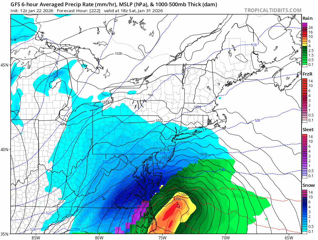
Updated -
Central PA Winter 25/26 Discussion and Obs
pasnownut replied to MAG5035's topic in Upstate New York/Pennsylvania
Best news if the day. Primary needs quick death or to be weaker to keep thermals safe. -

Winter 2025-26 Short Range Discussion
Chicago Storm replied to SchaumburgStormer's topic in Lakes/Ohio Valley
Dusted again as a result of the clipper last evening... Final snowfall totals 0.8" - ORD 0.7" - RFD …2025/26 Season Snowfall... 24.2" - ORD 23.9" - RFD -

January 2026 regional war/obs/disco thread
dendrite replied to Baroclinic Zone's topic in New England
My family will text me later ”is it true we’re getting 3ft of snow over the next couple weeks?”