All Activity
- Past hour
-
March 17 2012: The Twin Cities hits 80 degrees, a new record for St. Patrick's Day and the warmest temperature during the warmest March on record. Amazingly, the high also reached 79 on March 16, 18, and 19 this year. 1965: The Great St. Patrick's Day Blizzard hits northern Minnesota. Two feet of snow dumped at Duluth. 19 inches at Mora. ^^What a contrast in wx we can have in March ^^ For Tuesday, March 17, 2026 1892 - A winter storm in southwestern and central Tennessee produced 26 inches of snow at Riddleton, and 18.5 inches at Memphis. It was the deepest snow of record for those areas. (David Ludlum) 1906 - The temperature at Snake River, WY, dipped to 50 degrees below zero, a record for the U.S. for the month of March. (Sandra and TI Richard Sanders - 1987) 1987 - A powerful spring storm produced severe thunderstorms over the Central Gulf Coast States, and heavy snow in the High Plains Region. A tornado caused three million dollars damage at Natchez MS, and six inches of rain in five hours caused five million dollars damage at Vicksburg MS. Cactus TX received 10 inches of snow. Western Kansas reported blizzard conditions. (The National Weather Summary) (Storm Data) 1988 - A winter storm produced heavy snow from the northeast Texas panhandle to the Ozark area of Missouri and Arkansas. Up to fifteen inches of snow was reported in Oklahoma and Texas. Snowfall totals in the Ozark area ranged up to 14 inches, with unofficial reports as high as 22 inches around Harrison AR. (The National Weather Summary) (Storm Data) 1989 - Strong northerly winds ushered snow and arctic cold into the north central U.S. Winds gusted to 58 mph at Sydney NE and Scottsbluff NE, Cadillac MI received 12 inches of snow, and International Falls MN reported a record low of 22 degrees below zero. (The National Weather Summary) (Storm Data) 1990 - Showers and thunderstorms associated with a slow moving cold front produced torrential rains across parts of the southeastern U.S. over a two day period. Flooding claimed the lives of at least 22 persons, including thirteen in Alabama. Up to 16 inches of rain deluged southern Alabama, with 10.63 inches reported at Mobile AL in 24 hours. The town of Elba AL was flooded with 6 to 12 feet of water causing more than 25 million dollars damage, and total flood damage across Alabama exceeded 100 million dollars. Twenty-six counties in the state were declared disaster areas. (The National Weather Summary) (Storm Data)
-
.thumb.JPG.418e8a9a2902ae687ec35ff4bc0e038e.JPG) Ended up with a really nice snowfall. 4.5" as of 10 AM. Occasional light snow continues with the temp in the upper teens. What's really nice is this put me above 100" for the season!
Ended up with a really nice snowfall. 4.5" as of 10 AM. Occasional light snow continues with the temp in the upper teens. What's really nice is this put me above 100" for the season! -

Pittsburgh/Western PA WINTER ‘25/‘26
Rd9108 replied to Burghblizz's topic in Upstate New York/Pennsylvania
It wasnt even that much snow to shovel. Just straight ice -
Lol haven't heard that one in a while
-
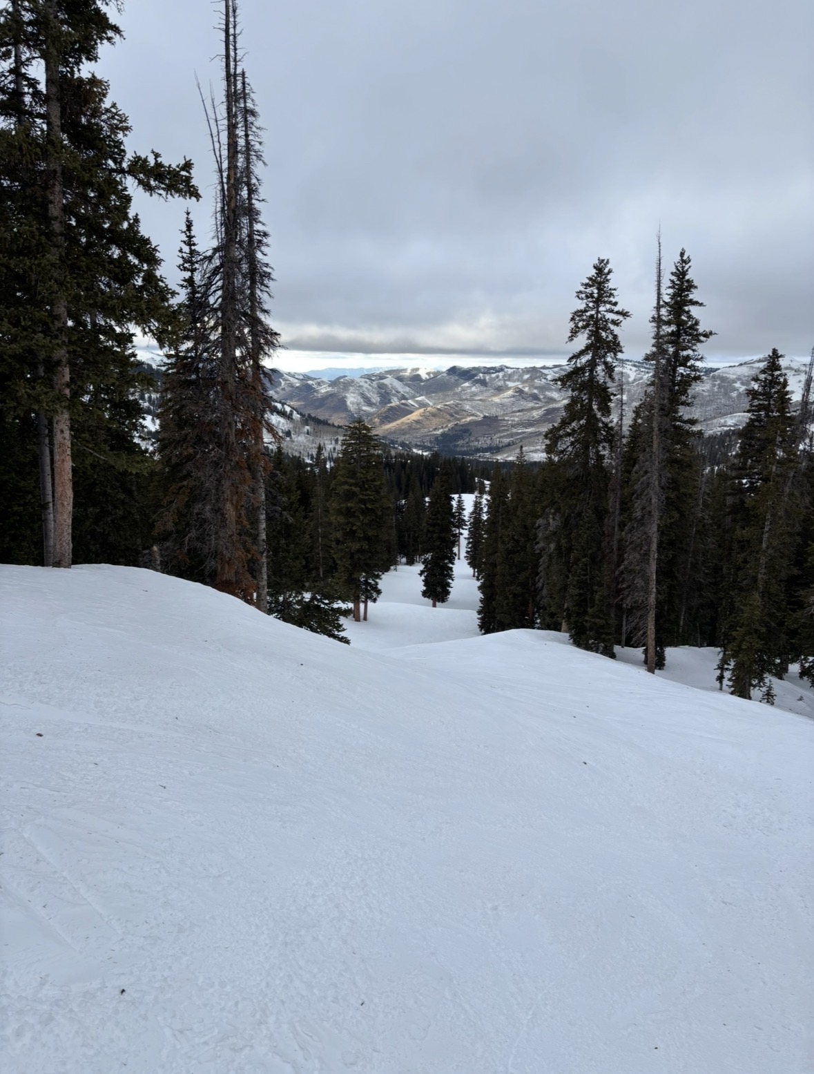
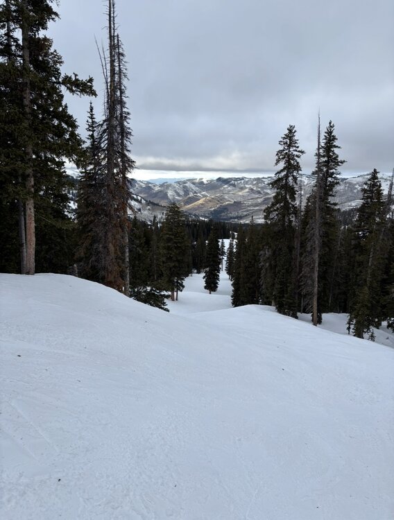
The crisis out west continues. As I sit in SLC, which received 3 inches of snow this year and is expecting more AN temps this week, a realization that a crisis is coming to the Colorado River this summer that we havent seen before. It looks like winter at Brighton, but you have to get above 7000 feet to get snow cover…and even then it is a fraction of normal.
-
3 inches.
-

2025-2026 Fall/Winter Mountain Thread
Tyler Penland replied to Buckethead's topic in Southeastern States
We must've gotten under a nice band overnight because I went to bed at 1/2" and woke up to a solid 3". Very nice surprise! -

E PA/NJ/DE Spring 2026 Obs/Discussion
Birds~69 replied to PhiEaglesfan712's topic in Philadelphia Region
Could be wrong but I think we were (Thunderstorm warning) till 11pm last night? Total 180 from yesterday, chilly and gusty out there... -
really? that's a high bar. I think i got the significant wording from the benchmark that the NWS has used forever. 6+ = warning snowfall and the wording in the watches and warnings usually includes "significant". And before they switched to "light, moderate, heavy" accumulations in the zones it used to be "significant" for anything that would meet warning criteria. So i personally use moderate for advisory and significant for warning level or higher which that storm in Dec definitely was. It's all subjective and personal opinion though.. Yeah Jan 03 sucked here, there was a tight gradient in CT though. Similar to the christmas blizzard. Dec 03 and Jan 05 i lump into the same bucket of a long duration shredded radar mess. They were both pretty bad. Dec 05 was wild but still way better out east about 6-12 for most of CT
-
I have and sometimes still do. Back around 2014-2018 I reported almost daily but it became too much of a chore. MQT gave me my two official snow stakes that I still put out each year for shits and giggles.
-
RIP Roger.
-
It did give most of the country a torch-the immediate east coast was the exception
-
It was 24 this morning and 29 currently
-
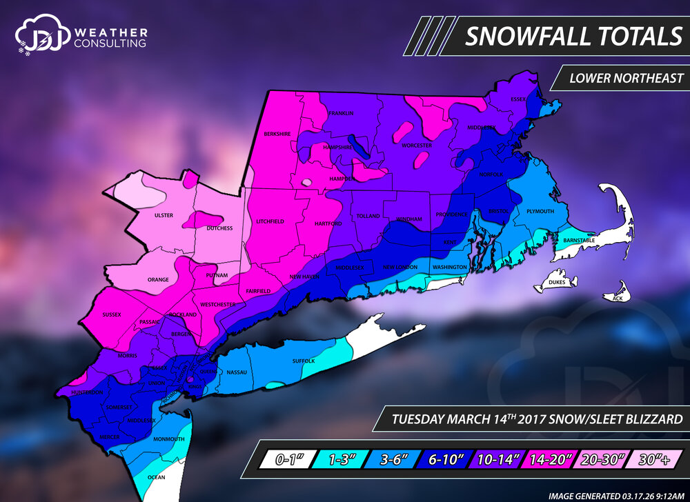
A little late past the anniversary but i updated the pi-day blizzard as well as Dec 2009 and Jan 21-22 2014 with new snowfall maps
-
Just curious, but do you send pics to NWS MQT?
-
I didn't expect a real winter, not with that Pacific jet out there...
-
@eyewall I thought the same thing when I walked out yesterday morning and posted here. It didn’t feel like a volatile airmass especially with the midday timing. Unless it’s a derecho or there isn’t any morning convection at all midday almost never works for severe. I never saw the sun yesterday btw.
-

-
30.7° at 10 am is just flat out impressive for this time of year
-
It would be, if it weren't so windy...
-
jelly
-
 .32" from the first round and .64" from last night. Not much wind fortunately. Snow fell for about an hour last night with no accumulation. Mountains are white this morning though. Much needed rain, at least.
- 1,049 replies
-
- 1
-

-
- severe
- thunderstorms
- (and 1 more)
-
This is EXCELLENT. The last thing he says is why this shouldn’t have been a 4 though: “There were a lot of questions, a lot of failure modes going into it”. If that was the case, the upgrade was not warranted because a level 4 risk states “high confidence” as a prerequisite to issue. If this had been kept at a level 3 overnight due to those questions the public would not have reacted the way they did and the perceived bust would be much less significant. Just my 0.02 but rarely so we see a day 2 level 4 and it seemed so preemptive we didn’t even start a thread here
-
A lot of LES/enhancement up there around MQT but a nice storm nonetheless.
-
35 right now Beautiful morning