All Activity
- Past hour
-
Like @donsutherland1 always says, not even worth looking at the CFS until you are into the final few days of the month, when it actually gets a semblance of having a clue about the following month. That said, in this climate, actually getting 4 months (Nov, Dec, Jan, Feb) in a row to all be below normal for temps, would be an extremely tall order….
-
Maybe another hour or so until better stuff arrives, if at all? I don’t see how this picks up anytime soon with radar the way it is.
-
NAM, HRRR (end of run), GFS, ECM are all pretty cold (and a little snowy) for Wed morning NWNJ and I-84 area. The Canadian and RRFS are a little warmer and pivot the steadier precipitation a little north of the area until the boundary layer warms. I'd like to see this evolve into a 1-2" deal for Sussex, Orange, Putnam with flakes (coating?) or sleet into northern Morris, Passaic, Rockland, Westchester.
-
Fits the Great Lakes cutter, I-78 to I-84 hugger and Rain-snow gradient, and suppressed Southern stream which has dominated since 2018-2019. Very difficult to achieve a true benchmark KU track with such a fast Pacific Jet. Way too many issues with kicker lows, amplified ridges pushing the gradient just north of NYC, and generally very poor wavelength spacing with so many shortwaves racing through the fast flow.
-
Temp wise they have been wrong for weeks, the long range models and the typical warm crew here that model hug
-
It’s like the Arctic Circle out there. I love it.
-
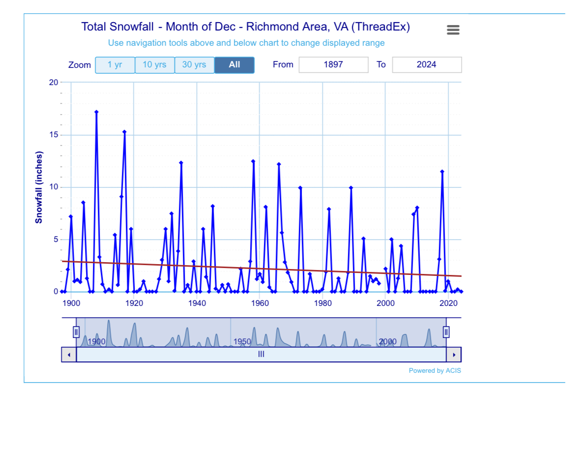
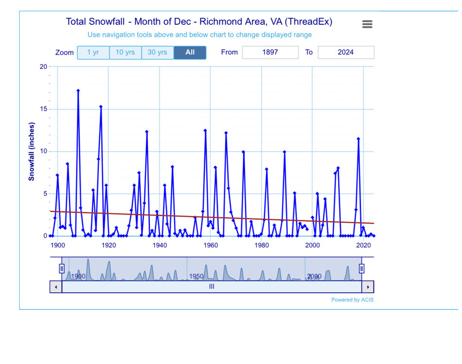
I don’t have the data for N NC, but RIC had a major snowfall in December 2018.
-
+TNH. It wouldn’t surprise me.
-

Southern MD / Lower Eastern Shore weather discussion
csnavywx replied to PrinceFrederickWx's topic in Mid Atlantic
Yeah, going to end up about 10-20 miles south. Got a few flakes so far this morning but the accumulating stuff is going to end up just south of here and probably just south of SBY as well. We've got at least 7 more days of this pattern though, so plenty of chances for more clippers. -
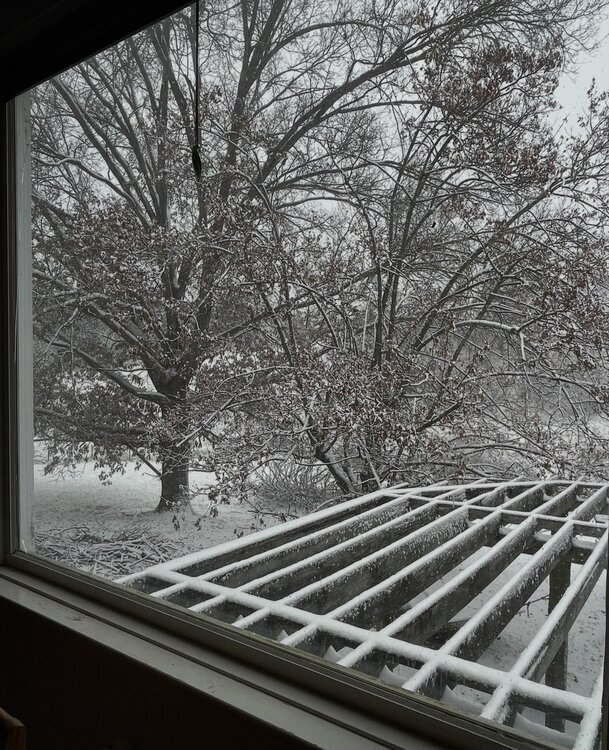
Snow started in the 5 o’clock to 6 o’clock range. Steady snow now at 31° and dropping. It's windy as heck, so this is fun to watch! About 1 inch so far.
-
(002).thumb.png.6e3d9d46bca5fe41aab7a74871dd8af8.png)
Central PA Fall Discussions and Obs
ChescoWx replied to ChescoWx's topic in Upstate New York/Pennsylvania
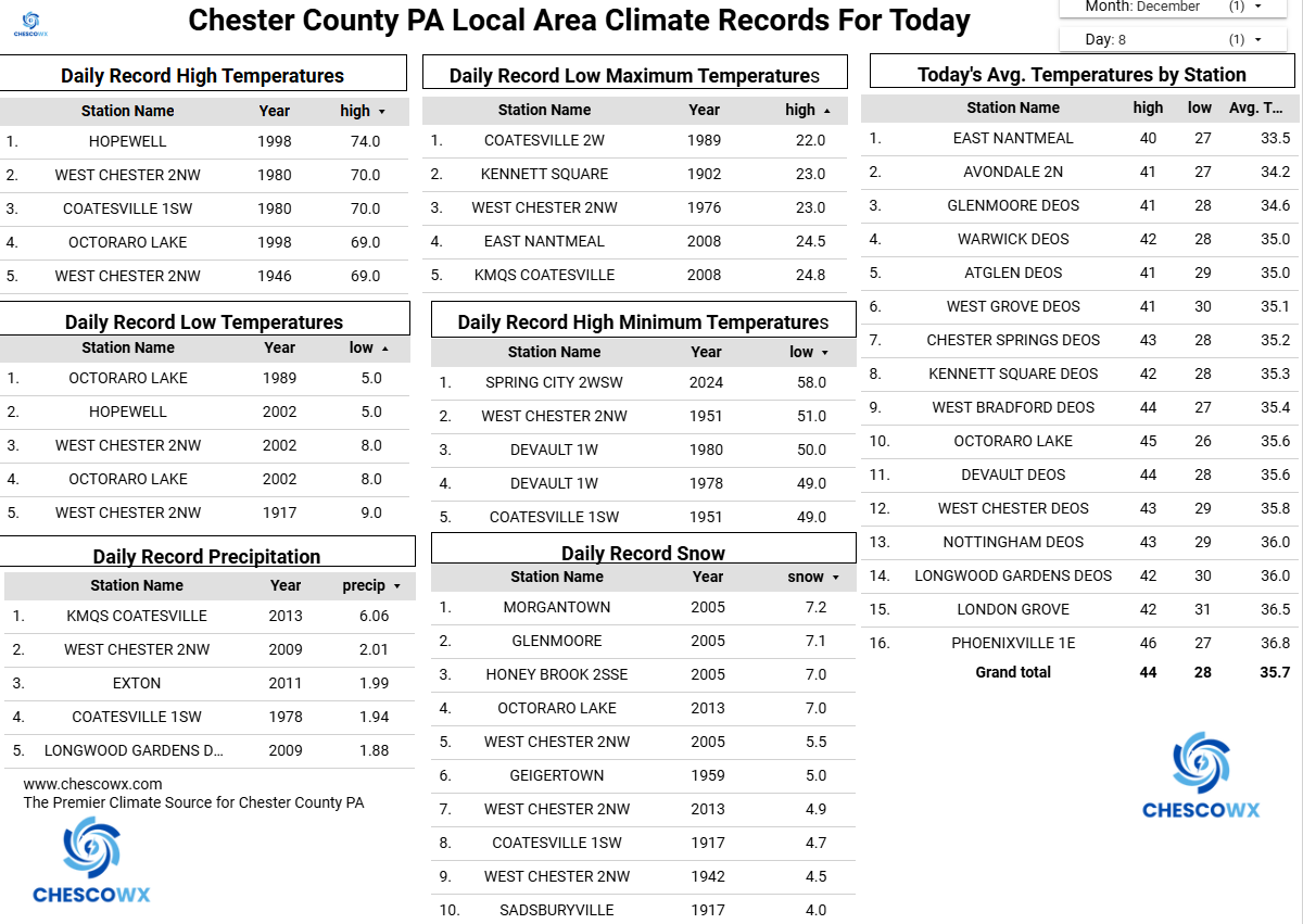
Following the arctic front passage temps have continued to slowly drop since sunrise across the area. Temperatures do not look to rise much today and remain in the upper 20's. Tonight will be the coldest night so far this season with lows not far from 10 degrees above zero. Some local station record lows will be broken including East Nantmeal record low was 17.7 back in 2010. We warm to near normal on Wednesday (this may be the last normal high temperature through Christmas) We should also see some snow arrive that will change pretty quickly to rain. We fall back below normal for the rest of the work week with additional snow chances arriving on Friday night into Saturday morning.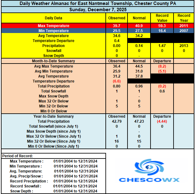
-

Southern MD / Lower Eastern Shore weather discussion
SnowtoRain replied to PrinceFrederickWx's topic in Mid Atlantic
It would be nice to see some better moisture signals in the mid to long range, somewhat similar to last winter where we could not shake drought conditions which are still persisting -
E PA/NJ/DE Winter 2025-26 Obs/Discussion
ChescoWx replied to LVblizzard's topic in Philadelphia Region
Following the arctic front passage temps have continued to slowly drop since sunrise across the area. Temperatures do not look to rise much today and remain in the upper 20's. Tonight will be the coldest night so far this season with lows not far from 10 degrees above zero. Some local station record lows will be broken including East Nantmeal record low was 17.7 back in 2010. We warm to near normal on Wednesday (this may be the last normal high temperature through Christmas) We should also see some snow arrive that will change pretty quickly to rain. We fall back below normal for the rest of the work week with additional snow chances arriving on Friday night into Saturday morning.
-

December 2025 regional war/obs/disco thread
Chrisrotary12 replied to Torch Tiger's topic in New England
Now this is a take I am in full agreement with. Anything outdoors (golf, yard cleanup, etc.) wraps up Thanksgiving. So let it snow! But by time Valentine’s Day rolls around, F snow and let the ground thaw and dry. Unless of course March 2018 is walking through the door. -
And the southern Piedmont of Virginia
-
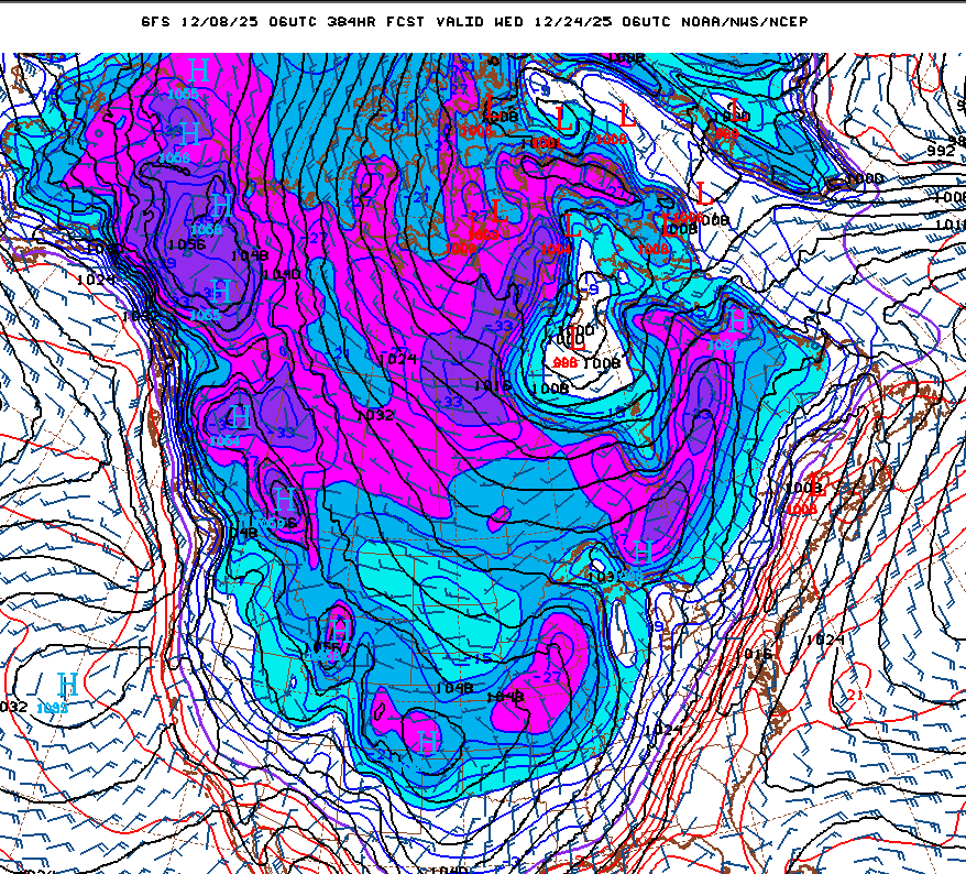
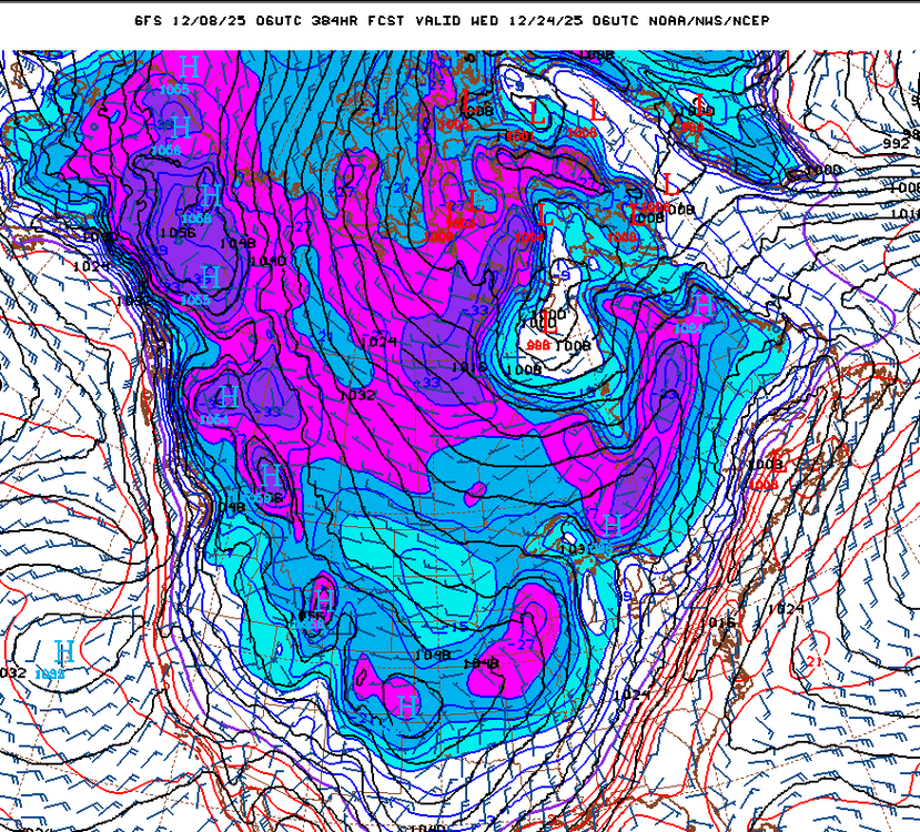
After a slight moderation leading into Christmas weeek, the 06Z GFS drops the arctic hammer across the U.S.
-

The Monday wintry event potential (12/8/25)
landof2rivers replied to GaWx's topic in Southeastern States
Flakes are starting to mix in. Whatever falls as snow is a win for me. If it ends up sticking that’s a bonus! -

2025-2026 Fall/Winter Mountain Thread
Maggie Valley Steve replied to Buckethead's topic in Southeastern States
Should get a break the next couple of hours as the cold front arrives and upslope snow begins. Temperature has risen to 35 now and the fog is only a couple of hundred feet above the Valley floor. -
If annoyance is my biggest "sin" and 90% of it happens just in this space here and it's about snow, I think I'm doing alright. Working on handling the disappointment still...but doing alright
-
E PA/NJ/DE Winter 2025-26 Obs/Discussion
ChescoWx replied to LVblizzard's topic in Philadelphia Region
My dad used to say the same things to me about the 1940's and 1950's growing up in Philly. Then I showed him the data. We all believe it was snowier and colder when we were kids. This is why we have facts to keep it real...not discounting memories. I have mentioned this before but from 1967 to 1978 Philly had no significant snows over 6" at all! Imagine if that occurred today the kids who grew up in our snowy climate since 2000 would be crying daily....kind of like they are now. LOL!! -
I still see some signs of something this afternoon, but idk what it is or what it’s trying to pick up on. It’s not organized banding but the hrrr is still showing some weird little impulse. Granted it’s the GFS, and double granted, it’s the gfs at nowcast time, but I do find it wild that it didn’t back down a single bit and almost shows some lee enhancement late morning.
-
At least in the years where it’s warm, you know you don’t have a shot. These last few years have been so hard because we’re always so close. It reminds me of the stretch in the mid 2000s (05-08?) where it snowed all around the foothills but we never cashed in until Dec 09. But even then we squeaked out a few small events.
-
Ski resorts continue to be the big winner the overpowering Northern Stream of the Pacific Jet.
-

December 2025 regional war/obs/disco thread
WinterWolf replied to Torch Tiger's topic in New England
That’d be nice. -
Snow levels are indeed falling. The camera on top of Hibriten Mtn in Lenoir is showing light snow beginning to fall. Elev: 2,211’