All Activity
- Past hour
-

Mid to long range discussion- 2025
WinstonSalemArlington replied to wncsnow's topic in Southeastern States
-
https://x.com/bam_weather/status/2000645576275231015?s=46&t=j_-aw-4tjFwrt5AoXKNk5A The Bam view is clear
-
I have been looking at the La Niña December snowfall in more detail last few days to try to find where a cutoff may be for average to above average snowfall. Previously used a 4” snowfall total for a rough approximation of a cutoff. Correcting for the Central Park under measurement they should be right at 4” and Newark is 4.2”. But all of the average to above snowfall seasons had 7.7”+in December like 2020, 2017, 2010, 2008, 2005, 2000, and 1995. The one exception was 2016. So it’s possible that the actual cutoff could be in the 4-7”range. It will be interesting to see how things work out the rest of the season. I am posting the Newark data below instead of NYC since they have a paid contract observer there. Even adding a bit to the NYC totals getting them closer to Newark shows the same relationship. 15 most recent La Niña Decembers using RONI and Total Seasonal Snowfall at Newark 24-25….3.5”…..13.6” 22-23….0.1”……2.7” 21-22….0.1”……17.9” 20-21…..11.9”…45.7” 17-18…….7.7”….39.4” 16-17……3.4”….30.0”…..The one year the relationship didn’t work out 11-12……0.0…..8.8” 10-11…..24.5”…68.2” 08-09….8.3”….27.1” 07-08….3.9”….14.6” 05-06….11.0”….37.9” 00-01….14.9”….39.3” 99-00……T…….18.4” 98-99….1.2”…..12.8” 95-96….12.8”….78.4”
-

-
It was just nice to finally see a widespread 4-8” clipper which used to be very common in the old days. I wonder if we can find a way to sneak in a KU that rapidly deepens near the benchmark with some portion of the area going 12” before the end of the season? My guess is that we will probably need at least one of these events for most spots from Newark out across Long Island to make it to closer to the long term average in the mid 20s for snowfall. It would be nice to finally see a bounce back year after the repeated lower totals last 7 years and lack of KU events. I have been looking at the La Niña December snowfall in more detail last few days to try to find where a cutoff may be for average to above average snowfall. Previously used a 4” snowfall total for a rough approximation of a cutoff. Correcting for the Central Park under measurement they should be right at 4” and Newark is 4.2”. But all of the average to above snowfall seasons had 7.7”+in December like 2020, 2017, 2010, 2008, 2005, 2000, and 1995. The one exception was 2016. So it’s possible that the actual cutoff could be in the 4-7”range. It will be interesting to see how things work out the rest of the season. I am posting the Newark data below instead of NYC since they have a paid contract observer there. Even adding a bit to the NYC totals getting them closer to Newark shows the same relationship. 15 most recent La Niña Decembers using RONI and Total Seasonal Snowfall at Newark 24-25….3.5”…..13.6” 22-23….0.1”……2.7” 21-22….0.1”……17.9” 20-21…..11.9”…45.7” 17-18…….7.7”….39.4” 16-17……3.4”….30.0”…..The one year the relationship didn’t work out 11-12……0.0…..8.8” 10-11…..24.5”…68.2” 08-09….8.3”….27.1” 07-08….3.9”….14.6” 05-06….11.0”….37.9” 00-01….14.9”….39.3” 99-00……T…….18.4” 98-99….1.2”…..12.8” 95-96….12.8”….78.4”
-
reminds me of how before I left Cville you could see snow on the tops of the mountains all around town but there was nothing on the ground at all in the university itself.
-
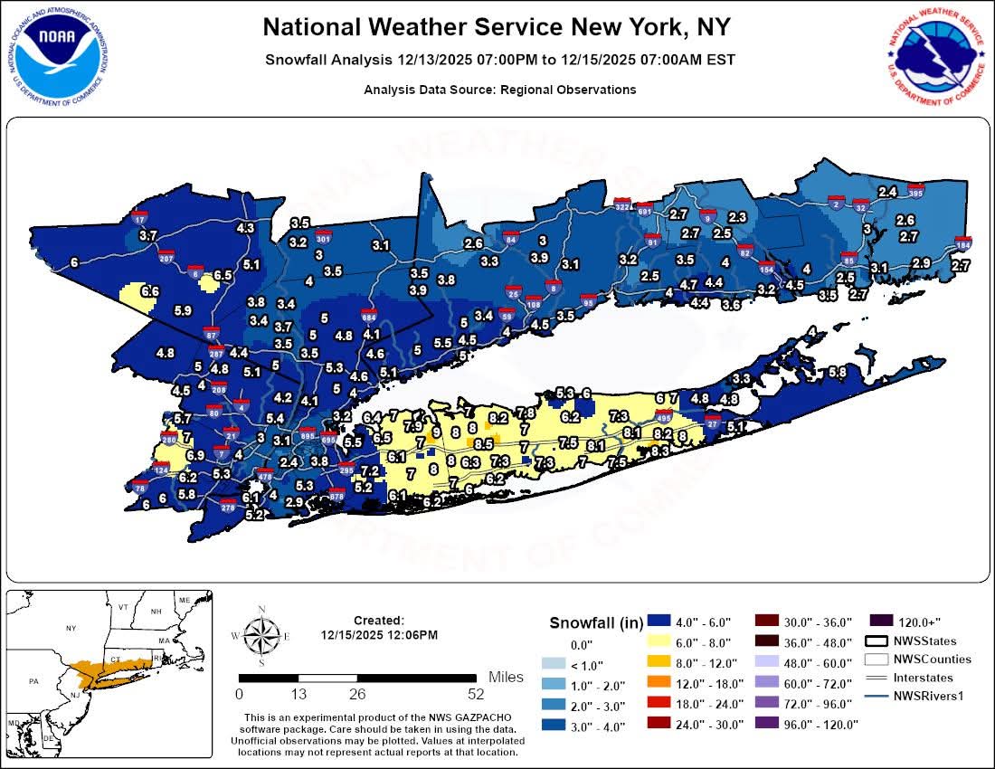
Something should be done and should've been done for years. Have a dedicated NWS observer there who will measure properly or take the obs someplace else. I can understand parts of the city having less because they struggled with temps for a while but that's just ludicrous how on TV there was clearly 3" with snow still coming down at a good clip and temps falling. JFK right on Jamaica Bay struggled with temps too and came in with 4.6". I showed pics of my neighborhood to a relative in FL yesterday and they were stunned about how much fell where I am vs "I heard the city only had 2". It's ridiculous.
-
Looks like the 12z EPS tries to tank the AO by Dec 27 - 30 timeframe. Roll it back another week for the usual model delay, and meat's back on the menu in the new year.
-

December 2025 regional war/obs/disco thread
HoarfrostHubb replied to Torch Tiger's topic in New England
I know it’s a long way off, but I don’t see a grinch system next week. The one this week seems highly likely but should be rather quick. After that I don’t feel another cutter hits before Dec 25 -
Downtown D.C. at 10' or so probably got .3"-.5" from the storm we just had. Move over to Arlington at even 100' you pretty solidly get 1". Just drove it the other day.
-

December 14th - Snow showers or Plowable snow?
bristolri_wx replied to Sey-Mour Snow's topic in New England

-
Mid to long range discussion- 2025
WinstonSalemArlington replied to wncsnow's topic in Southeastern States
Euro says rumors of Torchmas have been greatly exaggerated -
All right, I’ll take the bait because we’re in a boring stretch. .
-
Interested in the responses to this. I'm ~20 miles north of him and do better in some storms, but definitely feel the overall tenor of things seemingly cashing in north / south / west. Signed - a long time lurker driven out create an account over frustration from 'subsidence'
-

December 2025 regional war/obs/disco thread
WinterWolf replied to Torch Tiger's topic in New England
This is perfect. That’s all we need. well put and very reasonable. Nobody is in a fantasy world…we know the caveats, it doesn’t look great(the pattern), nothing wrong with stating that, but there is potential. And basing your negativity on Op runs at 8-11 days lead is just stupid/foolish. But ridiculous posts like, shut the shades, and this sucks, winter is over, we are boned(moaning like a little bi*ch), who cares if its early, it blows, I got 2” but was hoping for 3-4” so now it all sucks, etc etc…is downright ridiculous. That’s the point. -

December 2025 Short/Medium Range Forecast Thread
Carvers Gap replied to John1122's topic in Tennessee Valley
12z suite highlights. The 12z Euro(surprise!) now carries the banner for cold. The Dec20-30th timeframe for NE TN is normal-ish. It has the least feedback over the PNW. The Dec 19-20 cold front is now a "go" with it being legit Canadian cold. Can we score another front on the 22nd per the Euro - the GFS lost it, but I bet it's real. The really interesting one is the backdoor cold front on the 27th. Yes, it looks like Christmas should be warm with the cycle of warm fronts and cold fronts seeming to have it locked in between cold fronts - but who knows really. At nine days out, anything can happen. Maybe the really big news is the NAO looks on steroids on both the GFS and Euro 12z runs. It is east based, but retrograding to the West. It doesn't take much imagination to see a full latitude trough developing over NA between the Aleutian and NA ridges. A true block w precedent. -
Down to 6 here this Morning. 4 at Daughters house down in a Valley. Saw couple 2 and 3 degree's on Couple Weather Station's in the in the County.
-
Really no chances until maybe 12/23. Gotta hope we get a shortwave to run into the confluence which seems to be pretty stout on the ensembles…so there’s a good chance we’re at least seasonably cold during that period if not colder. But the question is whether we can get a system to fly around that ridge in the center of the country in time.
-
It's a crapshoot currently in my opinion.
-

Winter 2025-26 Medium/Long Range Discussion
roardog replied to michsnowfreak's topic in Lakes/Ohio Valley
Yeah. If your thing is just to have snowstorms then you’re almost better off hoping for above normal temps in the dead of winter. -
Out at Bacon Ridge, love that area. And yes, the snow line can be very pronounced. I've seen Trace to 2" within 30 feet vertical.
-

December 2025 regional war/obs/disco thread
brooklynwx99 replied to Torch Tiger's topic in New England
EPS is pretty active after the 22nd or so... there will be chances but it's shut the blinds for the next week -

December 2025 Short/Medium Range Forecast Thread
Daniel Boone replied to John1122's topic in Tennessee Valley
Yeah, we need those Features Opposite of where they are. Hopefully guidance is off with that Depiction but, looks pretty likely until Blocking sets up late Month or those features shift. -

December 2025 regional war/obs/disco thread
Ginx snewx replied to Torch Tiger's topic in New England
My thoughts exactly and I talked with Ray about this very subject. -
12z GFS op tries to give everyone a snow, or snow to ice event on 12/23.